Showing 32277 items
matching building
-
 Eltham District Historical Society Inc
Slide, Joh Ebeli, The old Baker's house prior to demolition, corner of York Street and Main Road, Eltham, c.Sep. 1979
Photo taken immediately prior to the demolition of the old baker's shop on the corner of Main Road and York Street, Eltham. Joh Ebeli and Elwers Howard endeavoured to preserve some parts of the house. The old weatherboard building, possibly dating from the 1860s, comprised a dwelling with a shop in the front room opening off a timber verandah deck which directly fronted the Main Road footpath. At the rear is a brick building of much later date which was for many years used for the bakery. The buildings were demolished for flat construction. Publicity at the time was oriented toward moves to preserve the weatherboard building which came from a number of individuals including members of this society. The society had no official connection with any proposal to retain the building or any part of it on any other site. The issues involved were part of a wider consideration of the matter of preservation of historic buildings. In this case the Society and in particular the committee had been aware for some years of the impending demolition. The possibility of the preservation of the building had been canvassed on a number of occasions. The Society’s view was that whilst the baker’s shop was an interesting old building which contributed to the character of Main Road, it was not of sufficient importance to wage an organised campaign for its preservation. It considered that if the building were to be preserved for historical reasons it would be far more feasible to retain it in its present location than to re-build it on another site.35 mm colour positive transparency Mount - Agfachrome Professional black (Germany) 4 dotsmain road, old eltham bakery, york street -
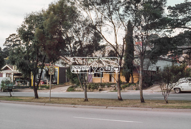
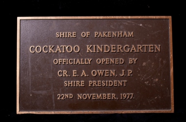 Cockatoo History & Heritage Group
Plaque, Cockatoo Kindergarten - Official Opening Plaque
In 1977 residents of Cockatoo built a kindergarten in McBride Street Cockatoo to service the growing population in the area. The building was officially opened on the 22nd of November of that year. Residents formed a Co-op, raised all the money to build the kinder along with lawn bowls and tennis sporting facilities for the town. No small feat, let alone for a town with a population of around 3000. The land was provided by the council for the kinder to use and that was their sole contribution to the building of the kinder. The unique building, was designed by Richard Allen and depicted a children's carousel. The design was to provide a feeling of enjoyment and friendship to the children who used the building. The large glass windows that were installed on the north-eastern side of the building made up 1/3 of the exterior wall. This overlooked the playground of the kinder making it easy to see the children at play from inside. The site of the building is in a dominant position and is highly visible to all who travel through Cockatoo. It was used as a child care facility right up until 2005. The kindergarten has recently been granted heritage listing after Cardinia Council started demolishing the building. The local community were successful in putting a halt to the demolition and saved the building. It will become an integral part of the Cockatoo Ash Wednesday memorial. Details on the fight to save the kinder building can be found at https://sites.google.com/site/cockatoosheritageashwednesday/ Brass Plaque, depicting the opening of the Cockatoo Kindergarten by the Shire of Pakenham Shire President - Cr OwenShire of Pakenham Cockatoo Kindergarten Officially Opened by Cr E A Owen J.P Shire President 22nd November 1977cockatoo, kindergarten opening, -
 Flagstaff Hill Maritime Museum and Village
Document - Framed Poster, Borough of Warrnambool, Victoria, Australia, after 30/06/1875
This document, also referred to as a word picture or Tablet, is framed in glass and timber with gilt trim, is handwritten with colour highlights. The penned letters rest on ruled guide lines, decorated where the lines intersect. The writing gives a description of the state of Borough of Warrnambool around 1875; its location, the area it covers, its population, Harbour and facilities, public buildings and institutions, imports and exports, financial worth, number of houses, connection with other areas of the Colony. A possible reason and origin for the document is found in an article ‘Link with US Exhibition’ from the Warrnambool Standard of December 19, 1981, written by local historian Bruce Morris. The writer mentions that the Warrnambool Borough Council met on 15th June 1875 and recorded a letter from G.C. Levey , secretary to the Melbourne group of commissioners representing the Colony, and Victoria in particular, for the Philadelphia Centennial Exhibition of 1876. The letter asks Council to provide “statistics as to the population, social condition and commercial and industrial state of the district in and around Warrnambool.” A sub committee was formed for the project. The Mayor, Cr. Thomas King, wrote and signed a Report, presented to the council on July 14, 1875, in which “The Committee … begs to recommend that a Tablet be prepared setting for the particulars respecting the following matters relating to the Borough”. The matters included area, population, annual income, churches, schools, other public buildings, societies and companies, general description of houses erected, and returns of exports and imports for 1874. The minutes note that the Report was adopted. The article above also notes the opinion of Warrnambool printers who have examined the document; it is almost certainly to be an old lithograph, which means there could be several copies. It is possible that there may be a copy in Melbourne and another in Philadelphia. It is interesting to note that (1) the quoted location co-ordinates are for an “Unnamed Road, Packsaddle NSW 2880, Australia”, and that the DMS co-ordinates for Warrnambool’s Council Offices differ, being 38.23.9.12 South, 142.28.52.887. (2) the date for “Exports and Imports for the Year Ending 30th June 1875” is different to the period mentioned by Cr. King in the sub committee’s Report of recommendation “returns of exports and imports for 1874”. The information required to have the figures for the end of June 1875 would need to have been compiled very quickly for the Tablet to be ready for the opening of the Philadelphia Exhibition on 10 May 1876. The document/certificate shows the following – - - - - - - - - - - - - - - -- - - - - - - - - - - - - - -- - - - - - - - - - - - - - -- - - - - - - - - - - - - - - “Victoria Australia, Borough of Warrnambool. Latitude, 30.24.50 South, Longitude 142.32 East The Principal Port in the Western District of the Colony and the Centre of its Choicest Agricultural Lands. Established a Municipality in 1855, and Created a Borough 1863. Population in 1875 4,500. Warrnambool is the nearest Port to Melbourne on the Western Seaboard, being about 160 miles distant. Coaches run to and from the Metropolis daily, in connexion [connection] with the Railway of Geelong and Steamers belonging to Local Companies sail between Melbourne, Warrnambool, Belfast [renamed Port Fairy], and Portland several times weekly. The Harbour is known as Lady Bay, and is partially protected by a reef of rocks stretching from the mouth of the Hopkins River. The formation of a Breakwater has been decided upon by the Government, to extend 600 yards, at an estimated cost of £100,000. There are two substantial Jetties, one of 800 and the other of 600 feet in length. The former is connected with the Town by means of a Tramroad, along which Goods, inwards & outwards, are conveyed, & the latter has been constructed solely for the purpose of facilitating the transit of material for the formation of the Breakwater. In addition to the trade of the Borough and District, the principal Townships up country receive their supplies from Melbourne and ship their exports through Warrnambool. Potatoes form the staple produce of the district, and the richness of the soil can be estimated by the fact that the Government Statistics for 1875 give as the average yield a return of Seven Tons to the acre. Several thousand acres between Warrnambool and Tower Hill are now being laid down in Potatoes by Tenants who have leased the lands at rates up to £5 per acre for the season 1875-6. Wool, Tallow, hides &c are also largely exported, while the shipments of all descriptions of Farm Produce are annually increasing. Area of Borough, 3362 Acres. Net Annual Value £27,000. Annual Revenue £5,500. Number of Houses in Borough 800. Public Buildings and Institutions Churches. Church of England, Roman Catholic, Presbyterian, Wesleyan, Congregational and Baptist. Schools. Three State Schools, average attendance nearly 1000. New Building in course of erection. Several private establishments. Banks. Bank of Australasia, Bank of Victoria, National Bank, Colonial Bank and Savings Bank. Public Buildings. Court house, Custom house, Post & Telegraph Offices, Survey & Land Offices, Shire £, Town Hall, Mechanics Institute, Volunteer Orderly Room, Odd Fellows Hall, Hospital & Benevolent Asylum, Temperance Hall &c. Companies & Societies. Steam Navigation Co, Woolen Mill Co, Gas Co, Racing Club, Amateur Turf Club, Agricultural Society, Farmers’ Club, Cricket Club, Anglers’ Society, Building Society, Freemasons Odd Fellows, Foresters, Druids, Hibernians. Protestant Alliance, Rechabites, Sons of Temperance, &c, Fire Brigade &c. --- Exports and Imports for the Year Ending 30th June 1875 –-- --Exports Total Tonnage 27,800 (Calculated at the Current Warrnambool Market Prices) Potatoes Wool Wheat Barley Hides Skins Fowls Butter Cheese Eggs Tallow Leather Ale Pigs Sheep Sundries --Imports 13,000 Tons Of the Estimated Value of £520,000 Total Tonnage of Exports and Imports 40m900 Tons, Value £806,627 Passenger Travels, to ad from Warrnambool during year, 10,000 persons Revenue from all sources paid through Warrnambool Sub Treasury From 1860 to June 1875 £1, 292, 300 Thomas King [signed] Mayor Henry T Read [signed] Town Clerk” - - - - - - - - - - - - - - -- - - - - - - - - - - - - - -- - - - - - - - - - - - - - -- - - - - - - - - - - - - - - The document is of historical, social, economic and local significance in that it summarises activities, business, community, trade, travel and government at a point in time in Warrnambool’s history – 30th June 1875.Document, also referred to as a ‘word picture’ or ‘tablet’. Document is framed in glass and timber with gilt trim, handwritten with colour highlights. The penned letters rest on ruled guide lines, decorated where the lines intersect. Document outlines the establishment of Warrnambool as a Municipality in 1855 and Borough in 1863, with a population of 4,500 in 1875. It states geographic location, public buildings and institutions, harbor facilities and imports and exports for the year ending 30th June 1875. Two signatures "Thomas King" Mayor and "Henry T Read" Town Clerk. It shows the Coat of Arms of the Borough of Warrnambool.Signatures - "Thomas King" Mayor and "Henry T Read" Town Clerk. Warrnambool Coat of Arms; “British Coat of Arms, above sailing vessel and sheaf of wheat in sun, motto “By these we flourish” and around circumference “Borough of Warrnambool 1855”flagstaff hill, warrnambool, shipwrecked coast, flagstaff hill maritime museum, maritime museum, shipwreck coast, flagstaff hill maritime village, great ocean road, borough of warrnambool, municipality of warrnambool, document borough of warrnambool 1875, word picture of warrnambool 1875, tablet of borough of warrnambool 1875, statistics borough of warrnambool 1875, lithograph borough of warrnambool 1875, coat of arms warrnambool, warrnambool city motto – in these we flourish, establishment of warrnambool, warrnambool history, thomas king mayor of warrnambool, henry t read town clerk of warrnambool, warrnambool breakwater, warrnambool jetty, warrnambool imports and exports 1875, warrnambool agriculture 1875, warrnambool business 1875, warrnambool population 1875, centennial exhibition philadelphia 1876, framed certificate -
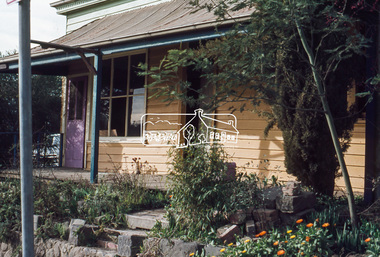
 Eltham District Historical Society Inc
Photograph, 23 Brougham Street, Eltham, July 2009, 2009
Alistair Knox designed buildingTwo colour photographsindustries, brougham street, diamond valley antiques and collectables, alistair knox -
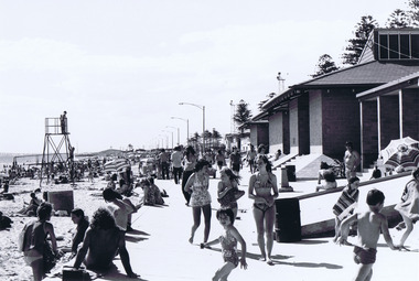 St Kilda Historical Society
Photograph, Elwood Beach
Shows buildings and people on beachblack and white photograph, unmounted, original, good conditionOn back: Elwood Beach -
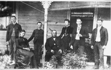 Malmsbury Historical Society
Photograph (Item), "Lasslett Family, Possibly William Lasslett Jnr", Malmsbury
People - Lasslett Buildings - House -
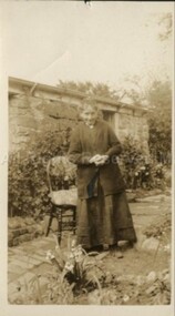 Malmsbury Historical Society
Photograph (Item), Mrs Crowe At Birth Room Malmsbury, Malmsbury
Buildings - Birthing Room Malmsbury -
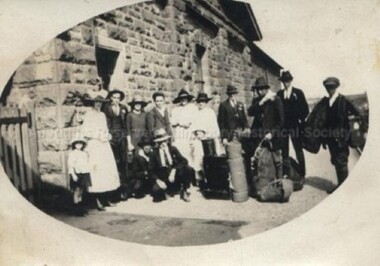 Malmsbury Historical Society
Photograph (Item), Group Of People Outside Malmsbury Station, Malmsbury
Buildings - Station Associated with - Railways -
 Malmsbury Historical Society
Photograph (Item), St John'S Anglican Church Altar Window Malmsbury, Malmsbury ca1990
Buildings - St John'S Church -
Malmsbury Historical Society
Photograph (Item), St John'S Church At Malmsbury, Malmsbury ca1990
Buildings - St John'S Church -
Malmsbury Historical Society
Photograph (Item), Church Of England, Malmsbury ca1970
Buildings - St John's Church -
Malmsbury Historical Society
Photograph (Item), Church Of England, Malmsbury ca1970
Buildings - St John's Church -
Malmsbury Historical Society
Photograph (Item), Cobb & Co Depot Cnr Of Patterson & Dalesford Rd, Malmsbury ca1970
Buildings - Cob & Co Depot -
Malmsbury Historical Society
Photograph (Item), Malmsbury Railway Station, Malmsbury ca1980
Buildings - Malmsbury Railway Station -
Malmsbury Historical Society
Photograph (Item), Malmsbury Railway Station, Malmsbury ca1980
Buildings - Malmsbury Railway Station -
Malmsbury Historical Society
Photograph (Item), St John's Church Of England Malmsbury Inside Damage, Malmsbury ca1980/90
Buildings - St-John's Church -
Malmsbury Historical Society
Photograph (Item), St John's Church Of England Malmsbury, Malmsbury ca1980/90
Buildings - St-John's Church -
Malmsbury Historical Society
Photograph (Item), St John's Church Of England Malmsbury Drying Out Knave, Malmsbury ca1980/90
Buildings - St-John's Church -
Malmsbury Historical Society
Photograph (Item), ront Of St John's Church Of England Malmsbury, Malmsbury ca1980/90
Buildings - St-John's Church -
Malmsbury Historical Society
Photograph (Item), Stained Glass Window Of St John's Church Malmsbury, Malmsbury ca1980/90
Buildings - St-John's Church -
Malmsbury Historical Society
Photograph (Item), Stained Glass Window Of St John's Church Malmsbury, Malmsbury ca1980/90
Buildings - St-John's Church -
Malmsbury Historical Society
Photograph (Item), Gold Leaf Inscription At St John's Church Malsbury, Malmsbury ca1980/90
Buildings - St-John's Church -
Malmsbury Historical Society
Photograph (Item), Central Arch Of Sanctuary Window At St John's Church, Malmsbury ca1980/90
Buildings - St-John's Church -
Malmsbury Historical Society
Photograph (Item), Water Damage To Ceiling At St John's Church, Malmsbury ca1980/90
Buildings - St-John's Church -
Malmsbury Historical Society
Photograph (Item), St John's Church Showing Lauristinas At F/Steps, Malmsbury ca1980/90
Buildings - St-John's Church -
 Malmsbury Historical Society
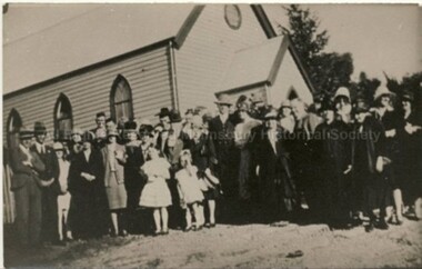
Photograph (Item), "Church Of England Lauriston With Group, A Wedding?", Malmsbury ca1900
Buildings - Church Associated with - Wedding -
 Malmsbury Historical Society
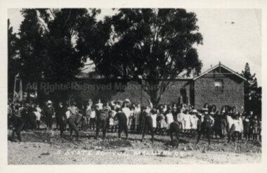
Photograph (Item), Malmsbury State School 1408 Planting S/Gardens, Malmsbury c1910
Buildings - Malmsbury State School -
Malmsbury Historical Society
Photograph (Item), Malmsbury Town Hall, Malmsbury ca1984
Buildings - Malmsbury Town Hall -
 Malmsbury Historical Society
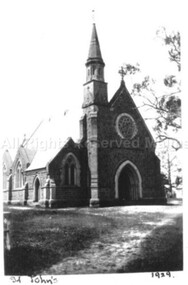
Photograph (Item), St Johns Church Malmsbury 1929, Malmsbury 1929
Buildings - St Johns Church