Historical information
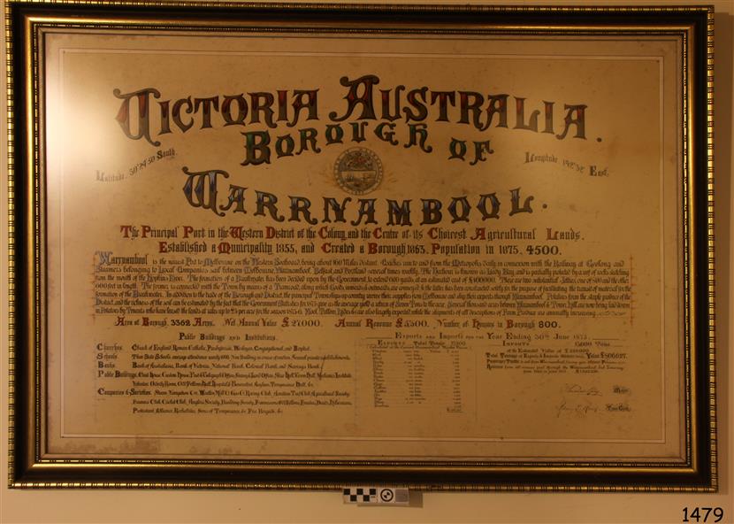
This document, also referred to as a word picture or Tablet, is framed in glass and timber with gilt trim, is handwritten with colour highlights. The penned letters rest on ruled guide lines, decorated where the lines intersect.
The writing gives a description of the state of Borough of Warrnambool around 1875; its location, the area it covers, its population, Harbour and facilities, public buildings and institutions, imports and exports, financial worth, number of houses, connection with other areas of the Colony.
A possible reason and origin for the document is found in an article ‘Link with US Exhibition’ from the Warrnambool Standard of December 19, 1981, written by local historian Bruce Morris. The writer mentions that the Warrnambool Borough Council met on 15th June 1875 and recorded a letter from G.C. Levey , secretary to the Melbourne group of commissioners representing the Colony, and Victoria in particular, for the Philadelphia Centennial Exhibition of 1876. The letter asks Council to provide “statistics as to the population, social condition and commercial and industrial state of the district in and around Warrnambool.”
A sub committee was formed for the project. The Mayor, Cr. Thomas King, wrote and signed a Report, presented to the council on July 14, 1875, in which “The Committee … begs to recommend that a Tablet be prepared setting for the particulars respecting the following matters relating to the Borough”. The matters included area, population, annual income, churches, schools, other public buildings, societies and companies, general description of houses erected, and returns of exports and imports for 1874. The minutes note that the Report was adopted.
The article above also notes the opinion of Warrnambool printers who have examined the document; it is almost certainly to be an old lithograph, which means there could be several copies. It is possible that there may be a copy in Melbourne and another in Philadelphia.
It is interesting to note that (1) the quoted location co-ordinates are for an “Unnamed Road, Packsaddle NSW 2880, Australia”, and that the DMS co-ordinates for Warrnambool’s Council Offices differ, being 38.23.9.12 South, 142.28.52.887. (2) the date for “Exports and Imports for the Year Ending 30th June 1875” is different to the period mentioned by Cr. King in the sub committee’s Report of recommendation “returns of exports and imports for 1874”. The information required to have the figures for the end of June 1875 would need to have been compiled very quickly for the Tablet to be ready for the opening of the Philadelphia Exhibition on 10 May 1876.
The document/certificate shows the following –
- - - - - - - - - - - - - - -- - - - - - - - - - - - - - -- - - - - - - - - - - - - - -- - - - - - - - - - - - - - -
“Victoria Australia, Borough of Warrnambool.
Latitude, 30.24.50 South, Longitude 142.32 East
The Principal Port in the Western District of the Colony and the Centre of its Choicest Agricultural Lands.
Established a Municipality in 1855, and Created a Borough 1863. Population in 1875 4,500.
Warrnambool is the nearest Port to Melbourne on the Western Seaboard, being about 160 miles distant. Coaches run to and from the Metropolis daily, in connexion [connection] with the Railway of Geelong and Steamers belonging to Local Companies sail between Melbourne, Warrnambool, Belfast [renamed Port Fairy], and Portland several times weekly. The Harbour is known as Lady Bay, and is partially protected by a reef of rocks stretching from the mouth of the Hopkins River. The formation of a Breakwater has been decided upon by the Government, to extend 600 yards, at an estimated cost of £100,000. There are two substantial Jetties, one of 800 and the other of 600 feet in length. The former is connected with the Town by means of a Tramroad, along which Goods, inwards & outwards, are conveyed, & the latter has been constructed solely for the purpose of facilitating the transit of material for the formation of the Breakwater. In addition to the trade of the Borough and District, the principal Townships up country receive their supplies from Melbourne and ship their exports through Warrnambool. Potatoes form the staple produce of the district, and the richness of the soil can be estimated by the fact that the Government Statistics for 1875 give as the average yield a return of Seven Tons to the acre. Several thousand acres between Warrnambool and Tower Hill are now being laid down in Potatoes by Tenants who have leased the lands at rates up to £5 per acre for the season 1875-6. Wool, Tallow, hides &c are also largely exported, while the shipments of all descriptions of Farm Produce are annually increasing.
Area of Borough, 3362 Acres. Net Annual Value £27,000. Annual Revenue £5,500. Number of Houses in Borough 800.
Public Buildings and Institutions
Churches.
Church of England, Roman Catholic, Presbyterian, Wesleyan, Congregational and Baptist.
Schools.
Three State Schools, average attendance nearly 1000. New Building in course of erection. Several private establishments.
Banks.
Bank of Australasia, Bank of Victoria, National Bank, Colonial Bank and Savings Bank.
Public Buildings.
Court house, Custom house, Post & Telegraph Offices, Survey & Land Offices, Shire £, Town Hall, Mechanics Institute, Volunteer Orderly Room, Odd Fellows Hall, Hospital & Benevolent Asylum, Temperance Hall &c.
Companies & Societies.
Steam Navigation Co, Woolen Mill Co, Gas Co, Racing Club, Amateur Turf Club, Agricultural Society, Farmers’ Club, Cricket Club, Anglers’ Society, Building Society, Freemasons Odd Fellows, Foresters, Druids, Hibernians. Protestant Alliance, Rechabites, Sons of Temperance, &c, Fire Brigade &c.
--- Exports and Imports for the Year Ending 30th June 1875 –--
--Exports Total Tonnage 27,800
(Calculated at the Current Warrnambool Market Prices)
Potatoes
Wool
Wheat
Barley
Hides
Skins
Fowls
Butter
Cheese
Eggs
Tallow
Leather
Ale
Pigs
Sheep
Sundries
--Imports 13,000 Tons
Of the Estimated Value of £520,000
Total Tonnage of Exports and Imports 40m900 Tons, Value £806,627
Passenger Travels, to ad from Warrnambool during year, 10,000 persons
Revenue from all sources paid through Warrnambool Sub Treasury
From 1860 to June 1875 £1, 292, 300
Thomas King [signed] Mayor
Henry T Read [signed] Town Clerk”
- - - - - - - - - - - - - - -- - - - - - - - - - - - - - -- - - - - - - - - - - - - - -- - - - - - - - - - - - - - -
Significance
The document is of historical, social, economic and local significance in that it summarises activities, business, community, trade, travel and government at a point in time in Warrnambool’s history – 30th June 1875.
Physical description
Document, also referred to as a ‘word picture’ or ‘tablet’. Document is framed in glass and timber with gilt trim, handwritten with colour highlights. The penned letters rest on ruled guide lines, decorated where the lines intersect.
Document outlines the establishment of Warrnambool as a Municipality in 1855 and Borough in 1863, with a population of 4,500 in 1875.
It states geographic location, public buildings and institutions, harbor facilities and imports and exports for the year ending 30th June 1875.
Two signatures "Thomas King" Mayor and "Henry T Read" Town Clerk.
It shows the Coat of Arms of the Borough of Warrnambool.
Inscriptions & markings
Signatures - "Thomas King" Mayor and "Henry T Read" Town Clerk.
Warrnambool Coat of Arms; “British Coat of Arms, above sailing vessel and sheaf of wheat in sun, motto “By these we flourish” and around circumference “Borough of Warrnambool 1855”
Subjects
- flagstaff hill,
- warrnambool,
- shipwrecked coast,
- flagstaff hill maritime museum,
- maritime museum,
- shipwreck coast,
- flagstaff hill maritime village,
- great ocean road,
- borough of warrnambool,
- municipality of warrnambool,
- document borough of warrnambool 1875,
- word picture of warrnambool 1875,
- tablet of borough of warrnambool 1875,
- statistics borough of warrnambool 1875,
- lithograph borough of warrnambool 1875,
- coat of arms warrnambool,
- warrnambool city motto – in these we flourish,
- establishment of warrnambool,
- warrnambool history,
- thomas king mayor of warrnambool,
- henry t read town clerk of warrnambool,
- warrnambool breakwater,
- warrnambool jetty,
- warrnambool imports and exports 1875,
- warrnambool agriculture 1875,
- warrnambool business 1875,
- warrnambool population 1875,
- centennial exhibition philadelphia 1876,
- framed certificate