Showing 211 items
matching bridge lane
-
 Eltham District Historical Society Inc
Photograph, Liz Pidgeon, Heritage Excursion; Back-track walk to Fitzsimons Lane, 2 July 2016, 2 July 2016
... and Fitzsimons Lane Bridge, based on the story on pages 3 and 4. Although... and Fitzsimons Lane Bridge, based on the story on pages 3 and 4. Although ...Newsletter No., 228, June 2016 Heritage Excursion – Back-track walk to Fitzsimons Lane – Saturday 2nd July Our July heritage excursion will be a walk to Yarra Hill Close and Fitzsimons Lane Bridge, based on the story on pages 3 and 4. Although the route is close to Fitzsimons Lane it will follow streets and paths that may not be familiar to many local residents. It will include commentary on the history of this corner of the Town of Eltham. This walk on Saturday 2nd July will follow a “there and back” route, that is returning over much the same course. It is about 2.5 km in length and will take 2 to 2.5 hours. It includes some hills. It will start at 2pm at the corner of Bolton Street and Old Eltham Road (Melway ref.21 F10).Born Digitalelection day, heritage excursion, activities, eltham district historical society, fitzsimons lane -
 Eltham District Historical Society Inc
Photograph, Liz Pidgeon, Heritage Excursion; Back-track walk to Fitzsimons Lane, 2 July 2016, 2 July 2016
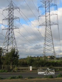
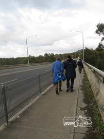
... and Fitzsimons Lane Bridge, based on the story on pages 3 and 4. Although... and Fitzsimons Lane Bridge, based on the story on pages 3 and 4. Although ...Newsletter No., 228, June 2016 Heritage Excursion – Back-track walk to Fitzsimons Lane – Saturday 2nd July Our July heritage excursion will be a walk to Yarra Hill Close and Fitzsimons Lane Bridge, based on the story on pages 3 and 4. Although the route is close to Fitzsimons Lane it will follow streets and paths that may not be familiar to many local residents. It will include commentary on the history of this corner of the Town of Eltham. This walk on Saturday 2nd July will follow a “there and back” route, that is returning over much the same course. It is about 2.5 km in length and will take 2 to 2.5 hours. It includes some hills. It will start at 2pm at the corner of Bolton Street and Old Eltham Road (Melway ref.21 F10).Born Digitalelection day, heritage excursion, activities, eltham district historical society, fitzsimons lane, power lines -
 Eltham District Historical Society Inc
Photograph, Liz Pidgeon, Heritage Excursion; Back-track walk to Fitzsimons Lane, 2 July 2016, 2 July 2016
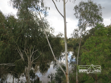
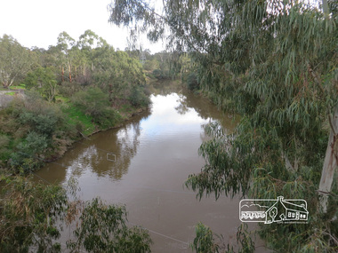
... and Fitzsimons Lane Bridge, based on the story on pages 3 and 4. Although... and Fitzsimons Lane Bridge, based on the story on pages 3 and 4. Although ...Newsletter No., 228, June 2016 Heritage Excursion – Back-track walk to Fitzsimons Lane – Saturday 2nd July Our July heritage excursion will be a walk to Yarra Hill Close and Fitzsimons Lane Bridge, based on the story on pages 3 and 4. Although the route is close to Fitzsimons Lane it will follow streets and paths that may not be familiar to many local residents. It will include commentary on the history of this corner of the Town of Eltham. This walk on Saturday 2nd July will follow a “there and back” route, that is returning over much the same course. It is about 2.5 km in length and will take 2 to 2.5 hours. It includes some hills. It will start at 2pm at the corner of Bolton Street and Old Eltham Road (Melway ref.21 F10).Born Digitalelection day, heritage excursion, activities, eltham district historical society, fitzsimons lane, yarra river -
 Eltham District Historical Society Inc
Photograph, Liz Pidgeon, Heritage Excursion; Back-track walk to Fitzsimons Lane, 2 July 2016, 2 July 2016
... and Fitzsimons Lane Bridge, based on the story on pages 3 and 4. Although... and Fitzsimons Lane Bridge, based on the story on pages 3 and 4. Although ...Newsletter No., 228, June 2016 Heritage Excursion – Back-track walk to Fitzsimons Lane – Saturday 2nd July Our July heritage excursion will be a walk to Yarra Hill Close and Fitzsimons Lane Bridge, based on the story on pages 3 and 4. Although the route is close to Fitzsimons Lane it will follow streets and paths that may not be familiar to many local residents. It will include commentary on the history of this corner of the Town of Eltham. This walk on Saturday 2nd July will follow a “there and back” route, that is returning over much the same course. It is about 2.5 km in length and will take 2 to 2.5 hours. It includes some hills. It will start at 2pm at the corner of Bolton Street and Old Eltham Road (Melway ref.21 F10).Born Digitalelection day, heritage excursion, activities, eltham district historical society, fitzsimons lane -
 Eltham District Historical Society Inc
Photograph, Liz Pidgeon, Heritage Excursion; Back-track walk to Fitzsimons Lane, 2 July 2016, 2 July 2016
... and Fitzsimons Lane Bridge, based on the story on pages 3 and 4. Although... and Fitzsimons Lane Bridge, based on the story on pages 3 and 4. Although ...Newsletter No., 228, June 2016 Heritage Excursion – Back-track walk to Fitzsimons Lane – Saturday 2nd July Our July heritage excursion will be a walk to Yarra Hill Close and Fitzsimons Lane Bridge, based on the story on pages 3 and 4. Although the route is close to Fitzsimons Lane it will follow streets and paths that may not be familiar to many local residents. It will include commentary on the history of this corner of the Town of Eltham. This walk on Saturday 2nd July will follow a “there and back” route, that is returning over much the same course. It is about 2.5 km in length and will take 2 to 2.5 hours. It includes some hills. It will start at 2pm at the corner of Bolton Street and Old Eltham Road (Melway ref.21 F10).Born Digitalelection day, heritage excursion, activities, eltham district historical society, fitzsimons lane, yarra river -
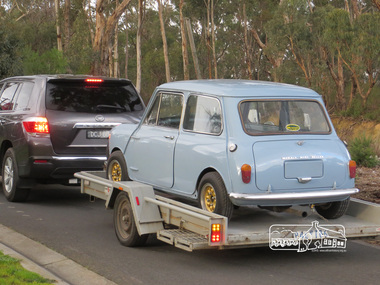 Eltham District Historical Society Inc
Photograph, Liz Pidgeon, Heritage Excursion; Back-track walk to Fitzsimons Lane, 2 July 2016, 2 July 2016
... and Fitzsimons Lane Bridge, based on the story on pages 3 and 4. Although... and Fitzsimons Lane Bridge, based on the story on pages 3 and 4. Although ...Mini on a trailer Newsletter No., 228, June 2016 Heritage Excursion – Back-track walk to Fitzsimons Lane – Saturday 2nd July Our July heritage excursion will be a walk to Yarra Hill Close and Fitzsimons Lane Bridge, based on the story on pages 3 and 4. Although the route is close to Fitzsimons Lane it will follow streets and paths that may not be familiar to many local residents. It will include commentary on the history of this corner of the Town of Eltham. This walk on Saturday 2nd July will follow a “there and back” route, that is returning over much the same course. It is about 2.5 km in length and will take 2 to 2.5 hours. It includes some hills. It will start at 2pm at the corner of Bolton Street and Old Eltham Road (Melway ref.21 F10).Born Digitalelection day, heritage excursion, activities, eltham district historical society, fitzsimons lane, mini -
 Eltham District Historical Society Inc
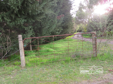
Photograph, Liz Pidgeon, Heritage Excursion; Back-track walk to Fitzsimons Lane, 2 July 2016, 2 July 2016
... and Fitzsimons Lane Bridge, based on the story on pages 3 and 4. Although... and Fitzsimons Lane Bridge, based on the story on pages 3 and 4. Although ...Newsletter No., 228, June 2016 Heritage Excursion – Back-track walk to Fitzsimons Lane – Saturday 2nd July Our July heritage excursion will be a walk to Yarra Hill Close and Fitzsimons Lane Bridge, based on the story on pages 3 and 4. Although the route is close to Fitzsimons Lane it will follow streets and paths that may not be familiar to many local residents. It will include commentary on the history of this corner of the Town of Eltham. This walk on Saturday 2nd July will follow a “there and back” route, that is returning over much the same course. It is about 2.5 km in length and will take 2 to 2.5 hours. It includes some hills. It will start at 2pm at the corner of Bolton Street and Old Eltham Road (Melway ref.21 F10).Born Digitalelection day, heritage excursion, activities, eltham district historical society, fitzsimons lane, gate -
 Eltham District Historical Society Inc
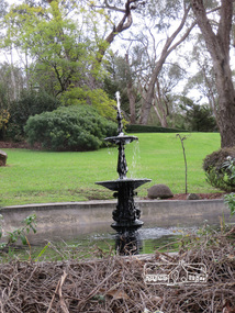
Photograph, Liz Pidgeon, Heritage Excursion; Back-track walk to Fitzsimons Lane, 2 July 2016, 2 July 2016
... will be a walk to Yarra Hill Close and Fitzsimons Lane Bridge, based... will be a walk to Yarra Hill Close and Fitzsimons Lane Bridge, based ...Water fountain on private property Newsletter No., 228, June 2016 Heritage Excursion – Back-track walk to Fitzsimons Lane – Saturday 2nd July Our July heritage excursion will be a walk to Yarra Hill Close and Fitzsimons Lane Bridge, based on the story on pages 3 and 4. Although the route is close to Fitzsimons Lane it will follow streets and paths that may not be familiar to many local residents. It will include commentary on the history of this corner of the Town of Eltham. This walk on Saturday 2nd July will follow a “there and back” route, that is returning over much the same course. It is about 2.5 km in length and will take 2 to 2.5 hours. It includes some hills. It will start at 2pm at the corner of Bolton Street and Old Eltham Road (Melway ref.21 F10).Born Digitalelection day, heritage excursion, activities, eltham district historical society, fitzsimons lane, water fountain -
 Eltham District Historical Society Inc
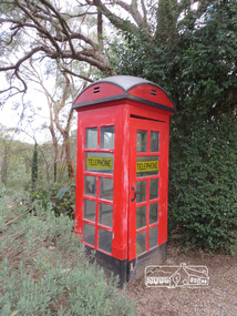
Photograph, Liz Pidgeon, Heritage Excursion; Back-track walk to Fitzsimons Lane, 2 July 2016, 2 July 2016
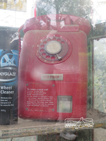
... will be a walk to Yarra Hill Close and Fitzsimons Lane Bridge, based... will be a walk to Yarra Hill Close and Fitzsimons Lane Bridge, based ...Red Public Phone Box now held privately Newsletter No., 228, June 2016 Heritage Excursion – Back-track walk to Fitzsimons Lane – Saturday 2nd July Our July heritage excursion will be a walk to Yarra Hill Close and Fitzsimons Lane Bridge, based on the story on pages 3 and 4. Although the route is close to Fitzsimons Lane it will follow streets and paths that may not be familiar to many local residents. It will include commentary on the history of this corner of the Town of Eltham. This walk on Saturday 2nd July will follow a “there and back” route, that is returning over much the same course. It is about 2.5 km in length and will take 2 to 2.5 hours. It includes some hills. It will start at 2pm at the corner of Bolton Street and Old Eltham Road (Melway ref.21 F10).Born Digitalelection day, heritage excursion, activities, eltham district historical society, fitzsimons lane, telephone, telephone box -
 Eltham District Historical Society Inc
Photograph, Liz Pidgeon, Heritage Excursion; Back-track walk to Fitzsimons Lane, 2 July 2016, 2 July 2016
... will be a walk to Yarra Hill Close and Fitzsimons Lane Bridge, based... will be a walk to Yarra Hill Close and Fitzsimons Lane Bridge, based ...Red public phone now out of use and in private hands. Newsletter No., 228, June 2016 Heritage Excursion – Back-track walk to Fitzsimons Lane – Saturday 2nd July Our July heritage excursion will be a walk to Yarra Hill Close and Fitzsimons Lane Bridge, based on the story on pages 3 and 4. Although the route is close to Fitzsimons Lane it will follow streets and paths that may not be familiar to many local residents. It will include commentary on the history of this corner of the Town of Eltham. This walk on Saturday 2nd July will follow a “there and back” route, that is returning over much the same course. It is about 2.5 km in length and will take 2 to 2.5 hours. It includes some hills. It will start at 2pm at the corner of Bolton Street and Old Eltham Road (Melway ref.21 F10).Born Digitalelection day, heritage excursion, activities, eltham district historical society, fitzsimons lane, telephone -
 Eltham District Historical Society Inc
Photograph, Liz Pidgeon, Heritage Excursion; Back-track walk to Fitzsimons Lane, 2 July 2016, 2 July 2016
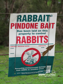
... will be a walk to Yarra Hill Close and Fitzsimons Lane Bridge, based... will be a walk to Yarra Hill Close and Fitzsimons Lane Bridge, based ...Sign attached to wire fence stating "RABBAIT PINDONE BAIT has been laid on this property to control RABBITS" Newsletter No., 228, June 2016 Heritage Excursion – Back-track walk to Fitzsimons Lane – Saturday 2nd July Our July heritage excursion will be a walk to Yarra Hill Close and Fitzsimons Lane Bridge, based on the story on pages 3 and 4. Although the route is close to Fitzsimons Lane it will follow streets and paths that may not be familiar to many local residents. It will include commentary on the history of this corner of the Town of Eltham. This walk on Saturday 2nd July will follow a “there and back” route, that is returning over much the same course. It is about 2.5 km in length and will take 2 to 2.5 hours. It includes some hills. It will start at 2pm at the corner of Bolton Street and Old Eltham Road (Melway ref.21 F10).Born Digitalelection day, heritage excursion, activities, eltham district historical society, fitzsimons lane, poison, rabbits -
 Eltham District Historical Society Inc
Photograph, Slab hut, Warrandyte, Warrandyte Mystery Tour, 29 May 1994, 29/05/1994
... the Bridge and along Bradley's Lane to Norman's Reserve brought us... the Bridge and along Bradley's Lane to Norman's Reserve brought us ...[article by Bettina Woodburn in EDHS Newsletter No. 97, July 1994:] THE WARRANDYTE MYSTERY TOUR MAY 29TH 1994 - Members of the Eltham Historical Society met at the Old Post Office, now converted into the Warrandyte Historical Museum, for a picnic lunch on the sunny back verandah overlooking the shimmering Yarra River. Interesting photographs and artefacts filled various rooms outlining the history of this area, and told tales of Aboriginal and more recent neighbours of the Eltham Shire. The weather was calm, cloudy mostly with only occasional sunny patches, but it wasn't cold, although the autumnal leaf colours had changed to wintry brown. "All Aboard" and we set off in the Warrandyte Community Bus (with the School Bus sign displayed at the rear) to learn about local places of "Pride and Joy” from Bruce our guide and Tom the driver. Almost directly opposite we entered Whipstick Gully to explore the first of the district's hidden treasures - the Victory, one of the largest of the six or so major mines, past the old quarry now used for abseiling practice. By torchlight we entered the rocky hillside and saw the seams of quartz the miners had followed in their search for gold. Stamping batteries, and there was one in this gully, converted discarded rock into 'road metal'. Warrandyte is proud to be the first declared Goldfield in 1851, and one of the longest surviving, into the 1920s. A pleasant drive across the Bridge and along Bradley's Lane to Norman's Reserve brought us to see another Tunnel at Pound Bend through which the Yarra was diverted to allow about three miles of river-bed to be used for prospecting for alluvial gold. Still on this side of the river we visited the Old Slab Hut in Castles Road. This remnant of miners' housing is preserved because it had been incorporated into a weatherboard house, and saved from the bulldozers - a last minute reprieve, for preservation, by the National Trust. Devastating bush fires have destroyed other old cottages built of wattle and daub, with bark roofs and stone fire-places. The Cairn commemorating the disclosure of Gold Discovery at Warrandyte on June 30th 1851 beside Anderson's Creek Road was our next point of historical interest. We drove on to South Warrandyte and circled back to above the ford on Anderson's Creek to the entrance of the 4th Hill Mine. Again we crept along with our torches, careful of the low roof-rock, and side shafts. At a junction in a large cavity we were able to stand, look up a long air-vent which some 'cavers' climb down, and marvel at, and experience an aspect of a miner's life. Outside we heard the same bird songs, the trills and bell-pealing, saw the same straggly eucalypts, and a silver leafed wattle in flower, native grasses and ferns, and the neat present day houses, often of Warrandyte stone, perhaps veneered only. The day ended pleasantly, seeing more of the Yarra from Everard Drive, and the water rushing out of the Tunnel at Pound Bend, before returning to afternoon tea or coffee at the Museum. A great day for all concerned - many thanks to the Organisers.Colour photographslab hut, warrandyte, "warrandyte miner's cottage" -
 Eltham District Historical Society Inc
Photograph, Pound Bend tunnel, Warrandyte, Warrandyte Mystery Tour, 29 May 1994, 29/05/1994
... the Bridge and along Bradley's Lane to Norman's Reserve brought us... the Bridge and along Bradley's Lane to Norman's Reserve brought us ...[article by Bettina Woodburn in EDHS Newsletter No. 97, July 1994:] THE WARRANDYTE MYSTERY TOUR MAY 29TH 1994 - Members of the Eltham Historical Society met at the Old Post Office, now converted into the Warrandyte Historical Museum, for a picnic lunch on the sunny back verandah overlooking the shimmering Yarra River. Interesting photographs and artefacts filled various rooms outlining the history of this area, and told tales of Aboriginal and more recent neighbours of the Eltham Shire. The weather was calm, cloudy mostly with only occasional sunny patches, but it wasn't cold, although the autumnal leaf colours had changed to wintry brown. "All Aboard" and we set off in the Warrandyte Community Bus (with the School Bus sign displayed at the rear) to learn about local places of "Pride and Joy” from Bruce our guide and Tom the driver. Almost directly opposite we entered Whipstick Gully to explore the first of the district's hidden treasures - the Victory, one of the largest of the six or so major mines, past the old quarry now used for abseiling practice. By torchlight we entered the rocky hillside and saw the seams of quartz the miners had followed in their search for gold. Stamping batteries, and there was one in this gully, converted discarded rock into 'road metal'. Warrandyte is proud to be the first declared Goldfield in 1851, and one of the longest surviving, into the 1920s. A pleasant drive across the Bridge and along Bradley's Lane to Norman's Reserve brought us to see another Tunnel at Pound Bend through which the Yarra was diverted to allow about three miles of river-bed to be used for prospecting for alluvial gold. Still on this side of the river we visited the Old Slab Hut in Castles Road. This remnant of miners' housing is preserved because it had been incorporated into a weatherboard house, and saved from the bulldozers - a last minute reprieve, for preservation, by the National Trust. Devastating bush fires have destroyed other old cottages built of wattle and daub, with bark roofs and stone fire-places. The Cairn commemorating the disclosure of Gold Discovery at Warrandyte on June 30th 1851 beside Anderson's Creek Road was our next point of historical interest. We drove on to South Warrandyte and circled back to above the ford on Anderson's Creek to the entrance of the 4th Hill Mine. Again we crept along with our torches, careful of the low roof-rock, and side shafts. At a junction in a large cavity we were able to stand, look up a long air-vent which some 'cavers' climb down, and marvel at, and experience an aspect of a miner's life. Outside we heard the same bird songs, the trills and bell-pealing, saw the same straggly eucalypts, and a silver leafed wattle in flower, native grasses and ferns, and the neat present day houses, often of Warrandyte stone, perhaps veneered only. The day ended pleasantly, seeing more of the Yarra from Everard Drive, and the water rushing out of the Tunnel at Pound Bend, before returning to afternoon tea or coffee at the Museum. A great day for all concerned - many thanks to the Organisers.Two colour photographswarrandyte, activities, pound bend -
 Eltham District Historical Society Inc
Document - Photocopy, Diamond Valley News, Newspaper article: Fred looks back by Linley Hartley, Diamond Valley News, c.1985
... the river down there on Fitzsimons Lane. There was no bridge... the river down there on Fitzsimons Lane. There was no bridge ...Fred looks back; Report: Linley Hartley, Picture: Ron Grant Teaching himself German again after 70 years is just one of the many tasks Fred Golgerth, of Greensborough, has undertaken and succeeded in during his lifetime. As the two year old tenth child of a German descendent, Fred learnt to speak German from an Aunt. But World War 1 was raging. Fred’s older brother had gone to Europe with the Australian forces, changing his name … to ….. to sound less German. “I used to get my bottom slapped for speaking German at home,” Fred said. Even his name was changed from Otto to the more anglicised Frederick. Fred claims his involvement with Eltham started two years before he was born! His sister, two years older than him, was a babe in arms when his parents bought a piece of grazing property in Mount Pleasant Rd. “It was about 24 acres on a spur of Mt Pleasant,” Fred said. “My parents bought it from Mr and Mrs Hughes. There was a two-room mud hut in wattle and daub that we lived in from time to time. “My parents had a dairy farm and dairy in West Coburg, and they bought the Mt Pleasant land to put the dry stock on. “At one stage my mother got very ill and my older sister took my younger sister and myself to Eltham for four or five months. I went down to Eltham Primary School then.” That wasn’t the only time Fred stayed in Eltham. His sister, Wilhemina, known as Willa, married Jim Watson who had the Eltham hotel for some years from the end of World War 1. Pillar to post living was the way Fred described his youth, when he stayed with one married sister after another. “After a while Will and Jim lived in the big house at the top of Pitt St, next to the Council depot, and the hotel was managed by Fitzsimmons who had a big place near the river down there on Fitzsimons Lane. There was no bridge in Fitzsimons Lane but we used to cross the river at a ford, rolling up our trouser legs so they wouldn’t get wet, and carrying our shoes. I’d o down to visit some friends I had in Templestowe. And sometimes Jim Watson took his horse drawn lorry across the ford on his way to the brewery, instead of going don through Heidelberg.” “The bridge across the Yarra in Fitzsimons was not built until 1961.” Fred Golgerth, was only a teenager when he was rolled off his pushbike under a car on the bend between Mt Pleasant Rd and the Diamond Creek bridge. He was hospitalised in the little hospital on the east side of Eltham village that served the district in those days. He still carries the scars of the burns he received from the exhaust pipe and recent x-rays have revealed several broken vertebrae. At the time of the accident he was treated for a dislocated neck and was in plaster from his hip to the base of his head for about seven months. But nothing daunted Fred. Bouncing back he began work as an apprentice to a motor mechanic in Bell St, Preston, a man who is still living (at 90) in Queensland and who still communicates with Fred frequently. “He was like a father to me,” Fred declared. He was a marine engineer as well, so I …. that as well as blacksmithing. They taught us properly then.” After finishing his apprenticeship, Fred bought himself a 30 hundredweight Fargo truck and began his own contract carting business, doing most of the work for a firm called Carnegie’s and a subsidiary of that, Howard Radio. It was in the office Fred met his wife. “He taught me to drive the truck giving me lessons in my lunch hours up the Bourke St and Flinders St extension,” she said. “After work I’d have a driving lesson and all the girls from the Howard Radio would pile in the back to get a lift to Richmond Station.” In the 1939 bushfires, the Mt Pleasant Rd property was burnt out and the hut raised. Two years later, Fred and Dorothy were married. Fred paid £7.15.0 ($15.50) for the suit in which he was married. Dorothy had pulled out of the Women’s Air Training Corps to be married. Others with whom she trained went to Darwin and were in a convoy that was bombed. Fred went into the garage business in Brighton and continued his cartage business for a while. His company was employed to do all Brown Gouge’s motor repairs and factory maintenance. Because Fred had a certificate to do steam repair work he often got jobs maintaining industrial boilers. While he was in Brighton, Fred bought an eight-seater 1925 Silver Ghost Rolls Royce from Sir Keith Murdoch. When the couple moved to Rosanna in about 1943, it became a delivery van for the dairy they operated. “I thought I’d like to get back into a dairy business” Fred said. “We used to deliver the milk in the Rolls. “But it was hard work. We couldn’t get the labour and we’d drive to the farm and pick up the milk cans, take them back to the dairy, cool the milk, bottle it and deliver it. The inspectors would come regularly and the walls for bacteria.” Fred was exhausted. The couple gave up the dairy and moved to Eltham to live on the old property where a weatherboard house had now been built. It wasn’t a big house and the glassed in Rolls Royce limousine became the daytime nursery for the Golgerth’s second daughter. We’d put her in there to sleep during the day.” “Dorothy Golgerth was known to drive the Rolls at breakneck speed along Mt Pleasant Rd. Fred took some time off work then began driving a little local bus run by the Lyon Brothers before taking a maintenance job at the Athenaeum Club in the city. He’d ride an old Harley-Davidson to the station and travel into the city by train. Later, when the family moved to Pryor St. (their house stood where McEwans car park is now) Fred could walk to and from the station. “There was no resident doctor in the early days of Eltham,” Fred said. “Dr Cordner used to come from Greensborough to a room in the old house next to the old grocery shop on the corner of York St and Main Rd, Eltham (the grocery shop is now the Eltham Feed and Grain Store). The Golgerths lived in Eltham until “Dollar Day” – the day decimal currency became official. They eventually moved to Greensborough, when they have lived since. Fred has had his share of interesting jobs since then, retiring at 65 seven years ago when he was working in the engineering department at Larundel. Recently, two of his older sisters and a brother died, within a month. They were all in their 80s. They all had a profound influence on Fred, especially during his youth. His sharp wit and amusing anecdotes are the richer for his having been the youngest of a family that made the best of every circumstance. And now, as he enjoys his retirement, he is concentrating on relearning the language of his infancy; teaching himself German from tapes and a ‘teach yourself’ manual. He is fiercely proud of his German ancestry and treasures the diary, written in German in Gothic script, kept by his grandparents during their journey to Australia. On the inside in blue pen: "To Sadie, Wal Margaret & Elizabeth with lots & lots of love & best wishes from Mother"marg ball collection, eltham hotel, herbert james watson, otto (fred) golgerth, wilhemina watson (nee golgerth) -
 Eltham District Historical Society Inc
Photograph, Fay Bridge, EDHS Heritage Excursion, Culla Hill, Sweeneys Lane, Eltham, 7 September 2019
September Excursion - Culla Hill Walk Pioneer Eltham farmer Thomas Sweeney (1803 - 1867) named his house, “Culla Hill” after the area in Ireland that he came from. His house, now called “Sweeneys”, remains on a ridge line overlooking the Yarra River. It is recorded that Thomas Sweeney did well out of carting potatoes and other supplies to the various gold fields such as Bendigo, McIvor (Heathcote), Mount Alexander and Beechworth. Culla Hill is now the name of the road providing access to subdivided lots of the former Sweeney property. The Culla Hill walk will start at the corner of Kent Hughes and Lavender Park Roads, Eltham (Melway ref. 22 A9) at 2.00pm on Saturday 7th September. - EDHS Newsletter No. 247 August 20192019-09-07, activities, culla hill, eltham, eltham district historical society, fay bridge collection, heritage excursion, sweeneys lane -
 Eltham District Historical Society Inc
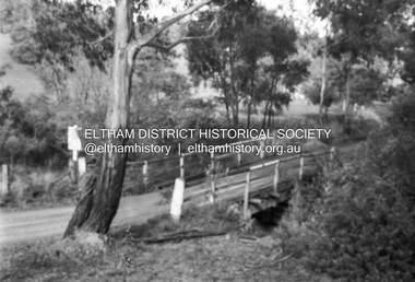
Negative - Photograph, Russell Yeoman, Bridge over Arthurs Creek, Chapel Lane, Nutfield, c.1970
... melbourne chapel lane arthurs creek nutfield Bridge Ilford HP4 Roll ...Roll of 35mm black and white negative film, 4 of 7 strips and corresponding B&W printIlford HP4chapel lane, arthurs creek, nutfield, bridge -
 Eltham District Historical Society Inc
Photograph, Liz Pidgeon, EDHS Heritage Walk: Shillinglaw Farm, Eltham, 2 September 2023
On Saturday September 2, 2023, Russell Yeoman led a group of 22 society members and interested others on a walk following trhe bounadries of the original Shillingalw farm. Commencing at the corner of Panther Place and Library Place, we proceeded up to Shillinglaw Cafe then the Shillinglaw trees at the former Eltham Shire Office site then along Main Road to the fire station then throughh St Laurence Lane and uinder the railway line , along Diamond Street then return via the Diamond Creek trail behind Andrew Park. The actual farm boundary went past the creek and further up the hill. The original farm comprised lot 90 of Holloway’s 1851 subdivision of Little Eltham. Its area was 30 acres lying east of the Diamond Creek and north of Henry Street. A number of stops were made to look at maps and early photos illustrating the gradual reduction of the farm area and the early history of the railway and other community uses, that occupied parts of the site.2023-09-02, activities, eltham, eltham district historical society, heritage excursion, shillinglaw farm, 895 main road, amplifon, andrew park, andrew pocket park, arthur street, bar de tapas, barber shop, barry plant estate agent, blockbuster, bus depot, car park, carparks, central park, cleaver & co hair, commonwealth bank, crust pizza, divine bridal, dr ash constance, dudley street, eltham book shop, eltham convenience store, eltham fire station, eltham library, eltham newsagency, eltham optical, eltham railway station, eltham shops, fay bridge, fire bell, flagpole, flight centre, grill'd, information sign, iso chook, jellis craig estate agent, judge book village, kebab nation, kx pilates, la zanyas, liquorland, little drop of poison, lorraine jones & associates solicitors, luck street, machan indian restaurant, main road, mecho en mexico, missing gorilla, morrison kleeman real estate, pavilion menswear, platform 3095, playtherapy melbourne, pryor street, ray white real estate, restaurants, sage bulk whole foods, shillinglaw trees, sign, snap fitness, southern cross medical imaging, specsavers, st laurence lane, st vincents care service, thompson's pharmacy, todaro, united service station, vyve body & skin, welcome to eltham town, westpac bank, yang's kitchen, youth road -
 Eltham District Historical Society Inc
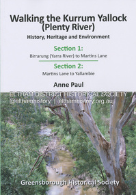
Book, Anne Paul, Walking the Kurrum Yallock (Plenty River), 25 July 2023
Kurrum Yallock - the Plenty River is Melbourne's third river. It is a defining feature of the region weaving its way through local suburbs and parklands. It is often hidden from general view, emerging at bridges and along its extensive trail network. While diminished since European settlement, the River provides an important environmental, wildlife corridor and recreational resource, along with many links to its settlement heritage. The Kurrum Yallock walks aim to guide people along the River Trail, while providing insight into key aspects of our recent history, an opportunity for reflection and an enhanced enjoyment of the River's special environment and landscape.birrarung, greensborough historical society, kurrum yallock, martins lane, plenty river, yallambie, yarra river -
 Eltham District Historical Society Inc
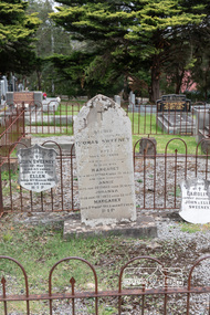
Photograph, Peter Pidgeon, Graves of Thomas Sweeney and family, Eltham Cemetery, Victoria, 5 April 2021
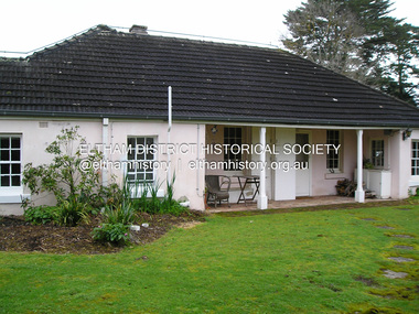
Irish-born Thomas Sweeney is regarded as the first settler in Eltham. He was transported to Sydney in 1823 after being convicted of arson. He was granted his freedom in 1838 and married Margaret Meehan in the same year. They moved to Melbourne and in 1842 Thomas purchased 110 acres beside the Yarra River in the vicinity of present-day Sweeneys Lane. He called the property ‘Culla Hill’ and built a small slab hut (reputedly with Wurundjeri help; Margaret is said to have run an informal hospital for them in return). This was followed in 1846 by more substantial buildings consisting of a three-roomed Irish-style ‘longhouse’ and a barn made of stone and handmade bricks, with doors large enough to accommodate a fully loaded wagon. When the gold rush came, Thomas prospered by selling meat and potatoes to the prospectors, enabling him to purchase a further 308 acres in 1856. He promoted the construction of a bridge over the Plenty River and the establishment of a school at Eltham. Roman Catholic Church services were held at Culla Hill in the early years. When he died in 1867, he was regarded as a respected member of the community. Thomas and Margaret are buried in Eltham Cemetery with many of their descendants. Their first son John continued to farm Culla Hill until his death in 1909. Culla Hill passed out of the Sweeneys' possession in 1939. The house and barn remain today, though lesser outbuildings have gone. The facade of the house is much the same as it was in the 1840s. Sacred To the memory of Thomas Sweeney Who died Sep 6th 1867 Aged 65 years May his soul res in peace Also his wife Margaret Died Oct 3rd 1884 aged 73 years And their daughters Annie Died Aug 22nd 1860 aged 21 years Johanna Died Aug 19th 1872 aged 22 years Margaret Died 7th Sep 1913 aged 72 years R.I.P. Also In Memory Of John Sweeney Died 24th May 1909 Aged 65 years Also of his wife Ellen Died 8th March 1910 Aged 64 years R.I.P Also In Memory Of Caroline Infant daughter of John & Ellen SweeneyBorn Digitalannie sweeney, eltham cemetery, gravestones, johanna sweeney, john murray, margaret sweeney, mary ellen drain, mary murray, thomas drain, thomas sweeney -
 Eltham District Historical Society Inc
Negative - Photograph, J.A. McDonald, Pinnacle Lane, Steels Creek, Sep. 1955
... . McDonald. 1955-09 Pinnacle Lane Steels Creek bridge construction ...The old bridge looking downstream Record of various Shire of Eltham infrastructure works undertaken during the period of 1952-1962 involving bridge and road reconstruction projects, sometimes with Eltham Shire Council Project Reference numbers quoted. It was during this period that a number of significant improvements were made to roads and new bridges constructed within the shire that remain in place as of present day (2022). In many situations, the photos provide a tangible visible record of infrastructure that existed throughout the early days of the Shire. The album was put together by or under the direction of the Shire Engineer, J.A. McDonald.1955-09, pinnacle lane, steels creek, bridge construction, infrastructure, shire of eltham -
 Eltham District Historical Society Inc
Negative - Photograph, J.A. McDonald, Pinnacle Lane, Steels Creek, Sep. 1955
... . McDonald. 1955-09 Pinnacle Lane Steels Creek bridge construction ...The old bridge looking eastwardsRecord of various Shire of Eltham infrastructure works undertaken during the period of 1952-1962 involving bridge and road reconstruction projects, sometimes with Eltham Shire Council Project Reference numbers quoted. It was during this period that a number of significant improvements were made to roads and new bridges constructed within the shire that remain in place as of present day (2022). In many situations, the photos provide a tangible visible record of infrastructure that existed throughout the early days of the Shire. The album was put together by or under the direction of the Shire Engineer, J.A. McDonald.1955-09, pinnacle lane, steels creek, bridge construction, infrastructure, shire of eltham -
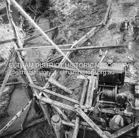 Eltham District Historical Society Inc
Negative - Photograph, J.A. McDonald, Pinnacle Lane, Steels Creek, Sep. 1955
... Lane Steels Creek bridge construction Infrastructure shire ...The old bridge from top of pile frameRecord of various Shire of Eltham infrastructure works undertaken during the period of 1952-1962 involving bridge and road reconstruction projects, sometimes with Eltham Shire Council Project Reference numbers quoted. It was during this period that a number of significant improvements were made to roads and new bridges constructed within the shire that remain in place as of present day (2022). In many situations, the photos provide a tangible visible record of infrastructure that existed throughout the early days of the Shire. The album was put together by or under the direction of the Shire Engineer, J.A. McDonald.1955-09, pinnacle lane, steels creek, bridge construction, infrastructure, shire of eltham -
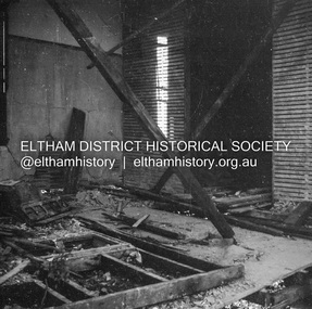
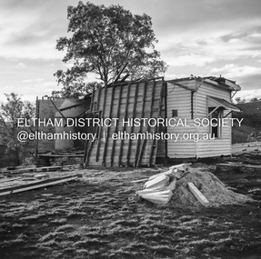
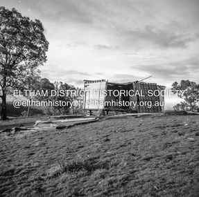
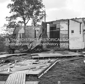
 Eltham District Historical Society Inc
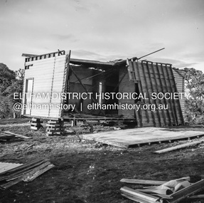
Negative - Photograph, J.A. McDonald, Inspection of storm damaged Abraham house at Kangaroo Ground, c. May 1962
Showing the effect of a wind storm that destroyed the house circa May 1962.. The Abraham family owned land near the Aqueduct and east of Nicholas Lane at Kangaroo Ground (based on photos, at or near 40 Nicholas Lane).Record of various Shire of Eltham infrastructure works undertaken during the period of 1952-1962 involving bridge and road reconstruction projects, sometimes with Eltham Shire Council Project Reference numbers quoted. It was during this period that a number of significant improvements were made to roads and new bridges constructed within the shire that remain in place as of present day (2022). In many situations, the photos provide a tangible visible record of infrastructure that existed throughout the early days of the Shire. The album was put together by or under the direction of the Shire Engineer, J.A. McDonald.1962-05, abraham house, kangaroo ground, nicholas lane, property damage, storm damage -
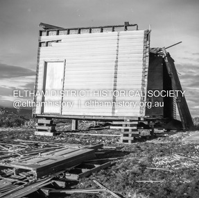 Eltham District Historical Society Inc
Negative - Photograph, J.A. McDonald, Inspection of storm damaged Abraham house at Kangaroo Ground, c. May 1962
Showing the effect of a wind storm that destroyed the house circa May 1962.. The Abraham family owned land near the Aqueduct and east of Nicholas Lane at Kangaroo Ground (based on photos, at or near 40 Nicholas Lane).Record of various Shire of Eltham infrastructure works undertaken during the period of 1952-1962 involving bridge and road reconstruction projects, sometimes with Eltham Shire Council Project Reference numbers quoted. It was during this period that a number of significant improvements were made to roads and new bridges constructed within the shire that remain in place as of present day (2022). In many situations, the photos provide a tangible visible record of infrastructure that existed throughout the early days of the Shire. The album was put together by or under the direction of the Shire Engineer, J.A. McDonald.1962-05, abraham house, kangaroo ground, nicholas lane, property damage, storm damage -
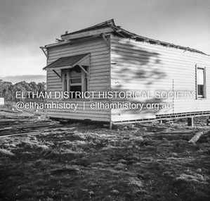 Eltham District Historical Society Inc
Negative - Photograph, J.A. McDonald, Inspection of storm damaged Abraham house at Kangaroo Ground, c. May 1962
Showing the effect of a wind storm that destroyed the house circa May 1962.. The Abraham family owned land near the Aqueduct and east of Nicholas Lane at Kangaroo Ground (based on photos, at or near 40 Nicholas Lane).Record of various Shire of Eltham infrastructure works undertaken during the period of 1952-1962 involving bridge and road reconstruction projects, sometimes with Eltham Shire Council Project Reference numbers quoted. It was during this period that a number of significant improvements were made to roads and new bridges constructed within the shire that remain in place as of present day (2022). In many situations, the photos provide a tangible visible record of infrastructure that existed throughout the early days of the Shire. The album was put together by or under the direction of the Shire Engineer, J.A. McDonald.1962-05, abraham house, kangaroo ground, nicholas lane, property damage, storm damage, building surveyor, george e. newton -
 Eltham District Historical Society Inc
Negative - Photograph, J.A. McDonald, Inspection of storm damaged Abraham house at Kangaroo Ground, c. May 1962
Showing the effect of a wind storm that destroyed the house circa May 1962.. The Abraham family owned land near the Aqueduct and east of Nicholas Lane at Kangaroo Ground (based on photos, at or near 40 Nicholas Lane).Record of various Shire of Eltham infrastructure works undertaken during the period of 1952-1962 involving bridge and road reconstruction projects, sometimes with Eltham Shire Council Project Reference numbers quoted. It was during this period that a number of significant improvements were made to roads and new bridges constructed within the shire that remain in place as of present day (2022). In many situations, the photos provide a tangible visible record of infrastructure that existed throughout the early days of the Shire. The album was put together by or under the direction of the Shire Engineer, J.A. McDonald.1962-05, abraham house, kangaroo ground, nicholas lane, property damage, storm damage