Showing 908 items
matching construction development
-
 Bialik College
Document (Sub-series) - Architect Ron Unger's papers relating to Auburn Road campus
... to this record. development construction buildings 1980s Document ...development, construction, buildings, 1980sdevelopment, construction, buildings, 1980s -
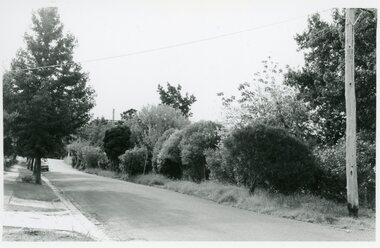
 Eltham District Historical Society Inc
Photograph, Site development, Main Road, Eltham East, 1995, 1995
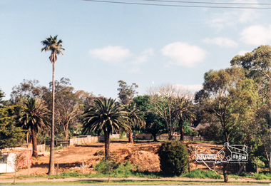
... Two colour photographs of construction of residential... photographs of construction of residential development on site ...Two colour photographs of construction of residential development on site of former house and garden Main Road, Eltham Eastmain road, eltham east, land development, trees -
 Kiewa Valley Historical Society
DVD SEC Victoria Promotional, Kiewa Capers Compilation, circa 1990
... The construction and development of the Kiewa Hydro scheme... The construction and development of the Kiewa Hydro scheme showing its ...The construction and development of the Kiewa Hydro scheme showing its construction and the people in work and play during its duration. It also shows the development of Mt Beauty and Bogong townships. The films were used as News Reels, Tourist Information and Entertainment.This VHS is a snap shot in time (1990) when the Kiewa Valley was still relatively under populated and holiday houses owned by city bound workers was still relatively insignificant. As more and more holiday makers retire to a small but friendly region(Kiewa Valley and Mount Beauty) the increase in visitor numbers will affect the local rural bush scene more and more. The changes that will occur (in time) can be measured against the scenes presented in this video. The additional resources provided by the State Electricity Commission of Victoria of "alpine bush" fire control and management, together with an ongoing educational scheme for school children in learning about what constitutes the Alpine country's unique environment, are a very important offshoot, benefitting to both the communitieThe DVD is nestled within a formed inner structure (case), which not only prevents the disc from moving to and fro but also unnecessary intrusion of foreign particles.This DVD is a TDK data/video recordable single sided 4.7 GB disc.It is a 1-16x speed.audio visual, kiewa history, educational -
 Kiewa Valley Historical Society
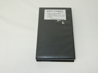
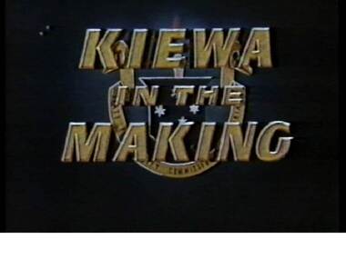
VHS Video - Kiewa, Kiewa Compile, Date compiled 25th Nov. 1998
... The construction and development of the Kiewa Hydro scheme... The construction and development of the Kiewa Hydro scheme showing its ...The construction and development of the Kiewa Hydro scheme showing its construction and the people in work and play during its duration. It also shows the development of Mt Beauty and Bogong townships. The films were used as News Reels, Tourist Information and Entertainment.This item provids a snap shot in time (1990) when the Kiewa Valley was still relatively under populated and holiday houses owned by city bound workers was still relatively insignificant. As more and more holiday makers retire to a small but friendly region(Kiewa Valley and Mount Beauty) the increase in visitor numbers will affect the local rural bush scene more and more. The changes that will occur (in time) can be measured against the scenes presented in this video. The additional resources provided by the State Electricity Commission of Victoria of "alpine bush" fire control and management, together with an ongoing educational scheme for school children in learning about what constitutes the Alpine country's unique environment, are a very important offshoot, benefitting to both the communities within the Kiewa Valley and regional Victoria.This VHS tape is stored within its own plastic cover which has a front side Titled "KIEWA in the MAKING". The VHS tape is nestled within a formed inner structure which not only prevents the tape from moving to and fro but also unnecessary intrusion of foreign particles. Titled "Kiewa Compile" with 4 short films titled 1. Kiewa in the Making 2. Kiewa Capers 3. It only seems like yesterday 4. Kiewa.kiewa, hydro electricity, state electricity commission of victoria, construction towns, 1940s 1960s, mt beauty, bogong, falls creek, clover power station, mckay power station, bill sutton, news film, construction workers, early machinery -
 Eltham District Historical Society Inc
Photograph, Fred Mitchell, Jarrold Cottage, 5 September 2007
... involved in the construction and development of the Montsalvat... involved in the construction and development of the Montsalvat ...Three historically significant buildings are here at 701 Main Road, opposite Dalton Street, Eltham. Jarrold Cottage or White Cloud was built about 1863 and remains one of the oldest buildings in Eltham. It was once used temporarily as Eltham’s first police station. The Jarrolds were a pioneer family of market gardeners and building tradesmen over six decades and from the early 1940s, with the Skippers and other prominent local figures involved in the construction and development of the Montsalvat Artists' Colony. Len Jarrold, a carpenter, worked at Montsalvat from the beginning and became foreman of works for the splendid 1938 Great Hall. The Skipper family, also involved with Montsalvat, were associated with Jarrold Cottage from 1944 when it was purchased by Lena Skipper. Digital copy of colour photographfred mitchell collection, 2007, eltham, jarrold cottage, main road -
 Wodonga & District Historical Society Inc
Photograph - Constructing the Hume Weir, c1928
... Dam during its initial construction and ongoing development... initial construction and ongoing development. Hume Dam took 17 ...This image is from Wodonga Historical Society's large collection of photographs documenting the construction of the Hume Dam during its initial construction and ongoing development. Hume Dam took 17 years to construct from the turning of the first sod on 28 November 1919 by Sir Ronald Munro-Ferguson, Governor-General of Australia. The first filling was in December 1934 and it was officially opened on 21 November 1936. Between 1950 and 1961 further modifications were made which enlarged its storage capacity. Progressive improvements have been made since that time to ensure the dam meets modern safety standards.This photo reflects a major stage in the construction of the Hume Dam.A large black and white image of construction of the Hume Weir on the Murray River mounted on board.hume dam construction, hume weir australia -
 Glen Eira Historical Society
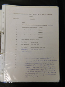
Document - Japanese School of Melbourne
... of school, development options, planning brief, construction time... of school, development options, planning brief, construction time ...Six documents about the Japanese School: 1/The Japanese School of Melbourne Planning Brief document draft February 1984 to the City of Caulfield. Brief includes background of school, current educational standards of school and structure, future plans, including forecast of future student numbers, request to use prefabricated rooms. Also plans for new building and room alterations. Includes appendice which has current and projection graph of students attending. Period covered: January 1968-February 1984 (17 pages). 2/Fourteen page school prospectus, which includes history and location, term dates, school hours, curriculum subjects, teachers qualifications, health department approval and enrolment list. Also includes Division of School Duties, school educational aims and guidance priorities. Period covered: 07/09/1968-13/05/1986. 3/An 11/11/1988 Melbourne Development and Prospectus for the Japanese School of Melbourne, includes purpose of school, development options, planning brief, construction time, and development program. Includes seven plans and maps of school location and bus routes (14 pages). Prepared for the City of Caulfield on its request. 4/List of representatives of the Japanese School of Melbourne that met with City of Caulfield councilors on 23/11/1988. 5/Black and white photo of 'Ian Rob with Japanese students September 1991', six students included. 6/Colour photograph of 'Mayor Ed Biggs with Japanese students February 1992', thirteen adults and young people included.japanese school of melbourne limited, japanese school, caulfield, holy cross catholic, holy cross school, ellington school, keeron street, mockridge stahle and mitchell architects, architects, secondary schools, primary schools, playgrounds, hawthorn road, caulfield south, yaji hidero, japanese community, yazaki yasuo, morita hiroshi, teachers, bloink des, stokes tony, building surveyors, japanese supplementary school of melbourne, school committees, libraries, school houses, brick, bloink clarke harding consulting architects group, anthony stokes and assoc. building surveyors and town planners, rob ian, biggs ed mayor -
 Orbost & District Historical Society
pamphlets, Princes Freeway - Orbost Section, 1976
... million. This construction was an important development along... $2.4 million. This construction was an important development ...Opened by the Hon. J A Rafferty, Minister for Transport, 25 November 1976, the bridge was the first of four bridges to be built as part of the freeway bypass of Orbost. Construction cost $2.4 million. This construction was an important development along the Princes Highway corridor through East Gippsland. The original highway approached the Snowy River at a very poor alignment, and several serious accidents had occurred at the Orbost end. In times of heavy flood, the highway on both sides of the river had been cut by floodwaters and during the 1971 floods, the highest ever recorded, the river was a mile wide at the crossing. Construction of the bridges commenced in January 1975, with an expectation to open the bridge across the Snowy River as soon as possible. Less than two years later, on 25 November 1976, the bridge across the Snowy River was opened to traffic, allowing the old bridge to be demolished. The remainder of the Orbost Bypass, both the floodplain crossings and the eastern section around the township itself, was declared ‘Princes Freeway’ and opened to traffic in December 1977. (ref http://mrv.ozroads.com.au) The Country Roads Board was the government authority for the construction and maintenance of main roads in Victoria between 1913 and 1983. It was succeeded by the Road Construction authority on 1 July 1983 and later merged with the Road Traffic Authority on July 1 1989 to form the Roads Corporation. James Cameron, an Orbost farming pioneer and Member of the Legislative Assembly, fathered the Country Roads Board. The opening of this Snowy River Bridge was an important development in the accessibility to the township of Orbost.Three coloured Country Roads pamphlets for the 'Princes Freeway - Orbost Section". On the front is a coloured photograph of the new construction over the Snowy River at Orbost. Inside is a program for a ceremony for the opening of the new Snowy River Bridge. There is also a black print map of the project. -
 The Beechworth Burke Museum
Photograph, c1900
This photograph shows a small timber house in Wooragee. In 1855, the Ovens district made a shift towards farming development that included the sales of land in the Wooragee Valley. This shift came because of miner's demands and concern about stabilising the area around the goldfield. Continual migration needed to be supported, unlucky diggers needed alternative employment, and there was a lack of affordable fresh produce available on the goldfields. Initially, the cost of land in areas like Wooragee was prohibitive, and miners chose to squat rather than overpay for poor land. Throughout the 1850s and 1860s, land reform was a key topic for miners and politicians, as they attempted to improve land access and protect financial interests. This photograph is an example of rural development in the Wooragee area, showing the cottage, tents, and garden beds. While the date is unknown, the image nevertheless links us to the 1850s-1860s story of rural development in Indigo Shire. Black and white rectangular photo, copy of original, printed on paper. wooragee, timber, timber cottage, corrugated iron, cottage, housing, tents, gardening, farming, farming and agriculture, construction, garden bed, flowers, verandah, squatting, tent, field -
 The Beechworth Burke Museum
Photograph - Stereoscopic Photograph, Unknown c1875
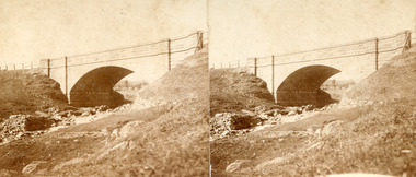
Depicted in the photograph is Newtown Bridge or the Newtown Falls Bridge, in Beechworth, Victoria. Noted for its location, detailed craftsmanship and stonemasonry by Scottish stonemasons the Newtown Bridge was built in the 19th century provincial town of Beechworth (completed in 1875). The bridge was built over Spring Creek, spanning 6.3 meters wide and 24.8 meters tall. Beechworth held a distinct role in the administrative and commercial management of Victoria's north-eastern goldfields, with many objects and structures still well preserved from the towns establishment. The bridge indicates the growth of the town, replacing a previous timber structure as well as its association to the mining activity in the area and the rapid increase in Australia's economy that led to investment and development of roads and railways. The local granite used in the construction of the single arch Newtown Bridge makes the bridge and other buildings made with the granite unique to the area, the honey-toned material distinct to Beechworth. This photograph is historically significant as it provides insight into the industrial development of Beechworth and the surrounding area, contributed to by the goldfields. The photograph further captures the representation of vernacular engineering traditions and Scottish stonemasonry.Two sepia-toned rectangular photographs featuring a bridge in the background printed on matte photographic paper mounted on card.Reverse: 97.2324/ Newtown Bridge/ Beechworthbridge, newtown beechworth, newtown bridge, newtown, beechworth, beechworth falls bridge, beechworth mining district, spring creek, -
 The Beechworth Burke Museum
Photograph, 1960
Taken in 1960, depicted is the construction of Lake Sambell, looking west across the lake. Lake Sambell is a beautiful Victorian recreation lake and urban park with a unique history. It was created in the mid-1800s by the Rocky Mountain Mining company during the gold rush era and used as a mining site until the early 1900s, which brought Europeans into the area. It was turned into a reserve for residents in 1920 and is considered an icon of Beechworth as it represents the development of the community, human endeavour, and the spirit of the landscape.This photograph represents additional construction to Lake Sambell as a recreational reserve.Black and white reproduced rectangular photograph print on paper.beechworth lake, lake, lake sambell, construction, #beechworth, australian landscape, beechworth 1960s, victoria -
 The Beechworth Burke Museum
Photograph, Unknown
Aerial view of Lake Sambell, Beechworth with town views. Lake Sambell is a beautiful Victorian recreation lake and urban park with a unique history. It was created in the mid-1800s by the Rocky Mountain Mining company during the gold rush era and used as a mining site until the early 1900s, which brought Europeans into the area. It was turned into a reserve for residents in 1920 and is considered an icon of Beechworth as it represents the development of the community, human endeavour, and the spirit of the landscape.This photograph represents Lake Sambell with town views.Black and white reproduced rectangular photograph print on paper.Reverse: Stampbeechworth lake, lake sambell, aerial photo, construction, australian landscape, #beechworth, victoria -
 The Beechworth Burke Museum
Geological specimen - Dolomite
Dolomite is a mineral, calcium magnesium carbonate, with the chemical formula CaMg(CO3)2. It is a principle component of various rock types sometimes also referred to as dolomite, including dolostone, dolomitic marble and dolomitic limestone (according to the composition of each type). Dolomite rock is found in sedimentary basins throughout the world, comprising approximately 2% of the Earth's crust. It is formed when lime mud or limestone encounters groundwater containing magnesium. Dolomite can contain elements such as lead, zinc and copper. Dolomite and limestone are used in various construction, landscaping and agricultural processes. This specimen was donated to the Burke Museum in 1868 by Alfred Selwyn as part of the Geological Survey of Victoria. It was donated to the Museum in 1868. Victoria and other regions of Australia were surveyed for sites of potential mineral wealth throughout the 19th Century. The identification of sites containing valuable commodities such as gold, iron ore and gemstones in a locality had the potential to shape the development and history of communities and industries in the area. The discovery of gold in Victoria, for instance, had a significant influence on the development of the area now known as 'the goldfields', including Beechworth; the city of Melbourne and Victoria as a whole. Dolomite and limestone are mined at several locations in Victoria, including sites in the North-East of the state in Bindi and Limestone Creek. There are notable dolomite deposits in most Australian states. The dolomitised form of the mineral tends to come from older limestone deposits, formed during the palaeozoic era in marine settings, so this specimen may have come from a deposit located along a coastline in Victoria or another state. The specimen is significant as an example of surveying activity undertaken to assess and direct the development of the mineral resource industries in Victoria and Australia, as well as the movement to expand human knowledge of earth sciences such as mineralogy and geology in the nineteenth century. This specimen is part of a larger collection of geological and mineral specimens collected from around Australia (and some parts of the world) and donated to the Burke Museum between 1868-1880. A large percentage of these specimens were collected in Victoria as part of the Geological Survey of Victoria that begun in 1852 (in response to the Gold Rush) to study and map the geology of Victoria. Collecting geological specimens was an important part of mapping and understanding the scientific makeup of the earth. Many of these specimens were sent to research and collecting organisations across Australia, including the Burke Museum, to educate and encourage further study.Hand-sized piece of pale pink dolomite (calcium magnesium carbonate) with dark grey rim and hollowed centre. geological specimen, geology, geology collection, burke museum, beechworth, dolomite, mineralogy, geological survey, alfred selwyn, limestone, calcium magnesium carbonate -
 The Beechworth Burke Museum
Photograph - Lantern Slide, c1900
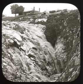
This image shows the gorge adjacent to Beechworth in approximately 1900. Although the exact location of the photograph is yet to be determined, the present-day Beechworth Gorge Walk includes views of the Cascades at the point at which Spring Creek flows into the valley on the level below. Gold-sluicing techniques in use in the town during periods of active gold extraction may have altered the landscape since the photograph was taken, however. In the 1850s a mill was built at the top of the Spring Creek falls by Russian-born Louis Chevalier, brother of artist Nicholas Chevalier. The mill supplied the town with lumber that supported the town's initial construction boom. Lantern slides, sometimes called 'magic lantern' slides, are glass plates on which an image has been secured for the purpose of projection. Glass slides were etched or hand-painted for this purpose from the Eighteenth Century but the process became more popular and accessible to the public with the development of photographic-emulsion slides used with a 'Magic Lantern' device in the mid-Nineteenth Century. Photographic lantern slides comprise a double-negative emulsion layer (forming a positive image) between thin glass plates that are bound together. A number of processes existed to form and bind the emulsion layer to the base plate, including the albumen, wet plate collodion, gelatine dry plate and woodburytype techniques. Lantern slides and magic lantern technologies are seen as foundational precursors to the development of modern photography and film-making techniques.This glass slide is significant because it provides insight into Beechworth's built environment and natural landscape in the early Twentieth Century, around the time of Australia's Federation. It is also an example of an early photographic and film-making technology in use in regional Victoria in the time period.Thin translucent sheet of glass with a square image printed on the front and framed in a black backing. It is held together by metals strips to secure the edges of the slide.burke museum, beechworth, lantern slide, slide, glass slide, plate, burke museum collection, photograph, monochrome, indigo shire, north-east victoria, spring creek falls, beechworth gorge, louis chevalier, nicholas chevalier, lumber industry, timber industry, 1850s, construction, building, mill, mills, waterfall -
 The Beechworth Burke Museum
Photograph - Lantern Slide, c1900
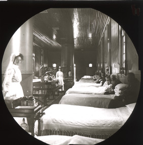
This glass slide captures a scene from a male hospital ward at Mayday Hills Mental Asylum. Also known as the Beechworth Lunatic Asylum, Mayday Hills was officially opened on the twenty-fourth of October 1867 and was commissioned following lobbying from Beechworth Municipal Council concerning a need for better living conditions for individuals confined to the town's gaol. These individuals, as well as many others who were brought from surrounding institutions, exhibited behaviours that were deemed to be unfit for mainstream society. At its peak, the asylum consisted of sixty-seven buildings and housed over twelve-hundred patients and five-hundred staff. At the time of Australian Federation in 1901 - just a year after this photograph was taken - the patient population numbered six-hundred and seventy-four. The asylum was officially closed in 1996. It is listed on the Victorian Heritage Register as being architecturally significant. The extensive complex of buildings are examples of Italianate-style, which is strongly associated with asylums of the 1860s - the period in which construction of this particular asylum began. Today the asylum offers tours to visitors, including daytime history tours and night-time ghost tours. Lantern slides, sometimes called 'magic lantern' slides, are glass plates on which an image has been secured for the purpose of projection. Glass slides were etched or hand-painted for this purpose from the Eighteenth Century but the process became more popular and accessible to the public with the development of photographic-emulsion slides used with a 'Magic Lantern' device in the mid-Nineteenth Century. Photographic lantern slides comprise a double-negative emulsion layer (forming a positive image) between thin glass plates that are bound together. A number of processes existed to form and bind the emulsion layer to the base plate, including the albumen, wet plate collodion, gelatine dry plate and woodburytype techniques. Lantern slides and magic lantern technologies are seen as foundational precursors to the development of modern photography and film-making techniques.This glass slide is socially and historically significant as it is representative of the lives of the nurses and patients at Beechworth Mayday Hills Asylum in the early twentieth century. It is also historically significant as it is representative of the changing style of treatments and attitudes towards mental illness. Thin translucent sheet of glass with a circular image printed on the front and framed in a black backing. It is held together by metal strips to secure the edges of the slide.Obverse: h /lantern slide, slide, glass slide, plate, burke museum collection, photograph, monochrome, mayday hills, mayday hills hospital, mayday hills asylum, beechworth lunatic asylum, beechworth mental asylum, psychiatric hostpital, beechworth, burke museum, beechworth municipal council, beechworth patients, psychiatric patients, victorian heritage register, 1900, 1900 mayday hills, italianate style, 19th century asylums, asylums victoria, male ward mayday hills -
 The Beechworth Burke Museum
Photograph - Lantern Slide, c1900
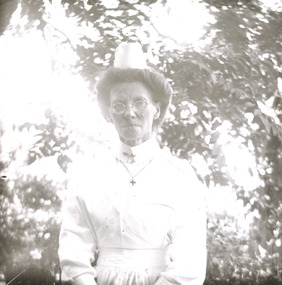
Taken in approximately 1900, this glass slide captures an image of a Mayday Hills Mental Asylum nurse. Also known as the Beechworth Lunatic Asylum, Mayday Hills was officially opened on the twenty-fourth of October 1867 and was commissioned following lobbying from Beechworth Municipal Council concerning a need for better living conditions for certain individuals confined to the town's gaol. These individuals, as well as many others who were brought from surrounding institutions, exhibited behaviours that were deemed to be unfit for mainstream society. At its peak, the asylum consisted of sixty-seven buildings and housed over twelve-hundred patients and five-hundred staff. At the time of Australian Federation in 1901 - just a year after this photograph was taken - the patient population numbered six-hundred and seventy-four. The designated site of the institution was chosen due to its scenery and altitude. It was argued that these picturesque surroundings would assist in curing the hospital's patients of their ailments. The asylum was officially closed in 1996. It is listed on the Victorian Heritage Register as being architecturally significant. The extensive complex of buildings are examples of Italianate-style, which is strongly associated with asylums of the 1860s - the period in which construction of this particular asylum began. Today the asylum offers tours to visitors: both daytime history tours and night-time ghost tours. Lantern slides, sometimes called 'magic lantern' slides, are glass plates on which an image has been secured for the purpose of projection. Glass slides were etched or hand-painted for this purpose from the Eighteenth Century but the process became more popular and accessible to the public with the development of photographic-emulsion slides used with a 'Magic Lantern' device in the mid-Nineteenth Century. Photographic lantern slides comprise a double-negative emulsion layer (forming a positive image) between thin glass plates that are bound together. A number of processes existed to form and bind the emulsion layer to the base plate, including the albumen, wet plate collodion, gelatine dry plate and woodburytype techniques. Lantern slides and magic lantern technologies are seen as foundational precursors to the development of modern photography and film-making techniques.This glass slide is socially and historically significant as it is representative of the lives of the nurses who worked at Beechworth's Mayday Hills Asylum in the early twentieth century. Thin translucent sheet of glass with a portrait image printed on the front. It is held together by metal strips to secure the edges of the slide.burke museum, beechworth, lantern slide, slide, glass slide, plate, burke museum collection, photograph, monochrome, mayday hills, mayday hills mental asylum, beechworth asylum, beechworth asylum nurses, psychiatric nurses, psychiatric care, 1900 mayday hills, victorian heritage register, italianate style, 19th century asylums, asylums victoria -
 The Beechworth Burke Museum
Photograph - Lantern Slide, c1900
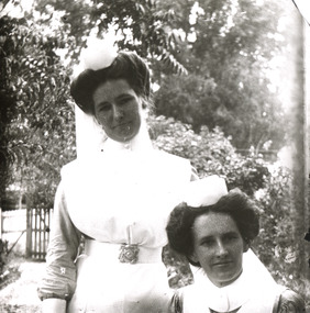
Taken in approximately 1900, this glass slide captures an image of two Mayday Hills Mental Asylum nurses. Also known as the Beechworth Lunatic Asylum, Mayday Hills was officially opened on the twenty-fourth of October 1867 and was commissioned following lobbying from Beechworth Municipal Council concerning a need for better living conditions for certain individuals confined to the town's gaol. These individuals, as well as many others who were brought from surrounding institutions, exhibited behaviours that were deemed to be unfit for mainstream society. At its peak, the asylum consisted of sixty-seven buildings and housed over twelve-hundred patients and five-hundred staff. At the time of Australian Federation in 1901 - just a year after this photograph was taken - the patient population numbered six-hundred and seventy-four. The designated site of the institution was chosen due to its scenery and altitude. It was argued that these picturesque surroundings would assist in curing the hospital's patients of their ailments. The asylum was officially closed in 1996. It is listed on the Victorian Heritage Register as being architecturally significant. The extensive complex of buildings are examples of Italianate-style, which is strongly associated with asylums of the 1860s - the period in which construction of this particular asylum began. Today the asylum offers tours to visitors: both daytime history tours and night-time ghost tours. Lantern slides, sometimes called 'magic lantern' slides, are glass plates on which an image has been secured for the purpose of projection. Glass slides were etched or hand-painted for this purpose from the Eighteenth Century but the process became more popular and accessible to the public with the development of photographic-emulsion slides used with a 'Magic Lantern' device in the mid-Nineteenth Century. Photographic lantern slides comprise a double-negative emulsion layer (forming a positive image) between thin glass plates that are bound together. A number of processes existed to form and bind the emulsion layer to the base plate, including the albumen, wet plate collodion, gelatine dry plate and woodburytype techniques. Lantern slides and magic lantern technologies are seen as foundational precursors to the development of modern photography and film-making techniques.This glass slide is socially and historically significant as it is representative of the lives of the nurses who worked at Beechworth's Mayday Hills Asylum in the early twentieth century.Thin translucent sheet of glass with a portrait image printed on the front. It is held together by metal strips to secure the edges of the slide.burke museum, beechworth, lantern slide, slide, glass slide, plate, burke museum collection, photograph, monochrome, 1900 mayday hills, mayday hills, beechworth mental hospital, beechworth mental asylum, beechworth asylum nurses, psychiatric nurses, psychiatric care, victorian heritage register, italianate style, 19th century asylums, asylums victoria -
 The Beechworth Burke Museum
Photograph - Lantern Slide, c1900
This image shows the gorge adjacent to Beechworth in approximately 1900. Although the exact location of the photograph is yet to be determined, the present-day Beechworth Gorge Walk includes views of the Cascades at the point at which Spring Creek flows into the valley on the level below. Gold-sluicing techniques in use in the town during periods of active gold extraction may have altered the landscape since the photograph was taken, however. In the 1850s a mill was built at the top of the Spring Creek falls by Russian-born Louis Chevalier, brother of artist Nicholas Chevalier. The mill supplied the town with lumber that supported the town's initial construction boom. Lantern slides, sometimes called 'magic lantern' slides, are glass plates on which an image has been secured for the purpose of projection. Glass slides were etched or hand-painted for this purpose from the Eighteenth Century but the process became more popular and accessible to the public with the development of photographic-emulsion slides used with a 'Magic Lantern' device in the mid-Nineteenth Century. Photographic lantern slides comprise a double-negative emulsion layer (forming a positive image) between thin glass plates that are bound together. A number of processes existed to form and bind the emulsion layer to the base plate, including the albumen, wet plate collodion, gelatine dry plate and woodburytype techniques. Lantern slides and magic lantern technologies are seen as foundational precursors to the development of modern photography and film-making techniques.This glass slide is significant because it provides insight into Beechworth's built environment and natural landscape in the early Twentieth Century, around the time of Australia's Federation. It is also an example of an early photographic and film-making technology in use in regional Victoria in the time period.Thin translucent sheet of glass with a square image printed on the front and framed in a black backing. It is held together by metals strips to secure the edges of the slide.burke museum, beechworth, lantern slide, slide, glass slide, plate, burke museum collection, photograph, monochrome, beechworth gorge, indigo shire, landscapes, mill, sluicing, gold mining, north-east victoria, spring creek, louis chevalier, cascades -
 The Beechworth Burke Museum
Photograph - Photograph - Reproduction, ca. 1900
This image shows the approach to Beechworth from the south-west via the Newtown Bridge. Numerous early buildings line the road as it bifurcates to become Ford and High Streets on the ridge above Spring Creek and Newtown Falls. The sloping, rocky terrain and water course along the gorge show evidence of the intense mining activity that occurred at the site. The Ovens Gold Rush at Beechworth started when gold was found at Spring Creek in February 1852, prompting an influx of miners from around the world. The population grew over 20,000 by 1857. While the earliest mining at Beechworth was similar to that in other Victorian goldfields like Ballarat and Bendigo, Beechworth is notable for its use of hydraulic sluicing as a major method of removing wash-dirt. Hydraulic sluicing employs high pressure jets of water to blast away large areas of earth and wash it down to be run through a sluice box. Gold gets caught in the sluice and the remaining slurry is washed away. This method of mining is extremely effective but causes significant environmental impacts and damage to waterways. Large water quantities were required for large-scale sluicing, and the long water races and deep tailraces that were constructed in the Beechworth area in the nineteenth century are nonetheless considered feats of engineering. The site in the photograph is associated with the Rocky Mountain Mining Company who constructed an eight hundred meter tunnel under the township between 1876-1880 to reduce water levels at Spring Creek, which had been subject to diversions since the earliest days of alluvial mining. Over four million ounces of gold (115 tones) were found at Beechworth between 1852 and 1868, and the wealth from the gold rushes built Beechworth and the nationally significant buildings that remain standing today.This image shows the early development of the Beechworth township above Spring Creek, where gold was discovered in 1852. Evidence of hydraulic sluicing, a uniquely predominant method at Beechworth, and water-works engineering are present in the landscape. By the 1870s, alluvial gold deposits were depleted and increasingly complex engineering was required so deeper shafts could reach bedrock. This image is significant for understanding changes to the landscape and the evolution of mining methods and engineering practices related to the extensive construction, manipulation and management of water networks. The shift from smaller scale alluvial mining to larger company dominance in the mining industry has implications for understanding wider social, economic, political and industrial changes in the region of Beechworth and within the context of the Victorian Gold Rush more broadly. A black and white rectangular reproduction photograph printed on photographic paper. burke museum, beechworth museum, beechworth, gold fields, gold rush, victorian gold rush, hydraulic sluicing, rocky mountain mining company, spring creek, netwown falls, mining tunnels, water races, tailraces, colonial australia, australian gold rushes, mining technology, beechworth historic district, indigo gold trail, migration, indigo shire, gold mining, gold mining history -
 The Beechworth Burke Museum
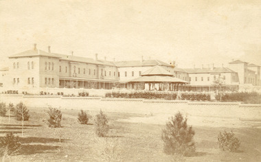
Photograph, Bayless C. - Manager, 1875
In this photo, taken in around 1875, is depicted the exterior of the Beechworth Mental Asylum buildings, with the administration buildings far right of the photo. A sunken boundary wall in the foreground and some people in view, sitting at the pavillion in the centre of the image. The two-storey buildings, designed in Italianate style, and the three-storey towers at the front, influenced by the asylum at Colney Hatch in England. The architecture of the buildings shares key features with other contemporary institutions, like Aradale at Ararat, and its design is attributed to the Public Works Department architect, J.J. Clark, whose name is connected with the construction of many other important public buildings, such as the Asylums at Kew and Ararat, the front block of the Royal Mint, Melbourne and the Melbourne Customs House. The Mayday Hills Hospital was constructed between 1864 and 1867, with buildings created in a number of periods. It formally opened on 24 October 1867 and, along with the Ovens Hospital and the Benevolent Asylum, made Beechworth a prominent social welfare centre in Victoria. Large masses of granite were excavated for its foundation and around 250 workmen were employed for its construction. The building, divided into six sections, was comprised of dormitories, doctors` rooms and plenty ancillary rooms and facilities, such as laundries, reading rooms, a concert hall and cooking areas. The site was chosen for its panoramic view of the countryside, the hilltop atmosphere and the native fauna, all contributing to the cure of patients. The Hospital was originally named the “Ovens Lunatic Asylum” but during the centenary celebrations in 1967 the name was officially changed to “Mayday Hills Hospital”, showing the gradual shift in the perception and understanding of mental health conditions over the last decades. The Hospital lies on the traditional land of the Kulin Nation.This photograph is historically significant as it provides an insight into the location, surroundings and the exterior of the Mayday Hills Hospital at the end of the 19th century. It also contributes to the understanding of the district`s development and its importance to the course of Victoria`s history and is acknowledged as a unique construction, being one of three identified as the largest of their kind.Black and white rectangular photograph printed on matte photographic paper mounted on board.Reverse: 37/ 3443/ Beechworth Asylum about 1875/ American & Australasian/Photographic Company/Victoria Branch./C.Bayless, Manager./ No./beechworth mental asylum, aradale, public works department, j.j. clark, melbourne customs house, colney hatch, italianate style, mayday hills hospital, royal mint, granite, benevolent asylum, dormitories, ovens lunatic asylum, ancillary rooms, centenary celebrations, three-storey towers, countryside, mental health conditions, kulin nation, concert hall -
 The Beechworth Burke Museum
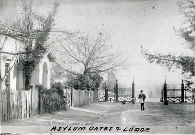
Photograph - Photograph Reproduction, 1890
The photo is taken in 1890 and a man is depicted, entering the main gates of the Mental Hospital at Beechworth, with the lodge on his right side. The man is dressed according to the australian fashion of that time, wearing a dark suit and a top hat. The countryside surrounding the Hospital is in the background. The Mayday Hills Hospital was constructed between 1864 and 1867, with buildings created in a number of periods. It formally opened on 24 October 1867 and, along with the Ovens Hospital and the Benevolent Asylum, made Beechworth a prominent social welfare centre in Victoria. The need for an institution of this kind was arisen due to the increased number of people with mental disturbances (induced by the harsh living conditions on the goldfields) and the remoteness of the district from Melbourne. The site was chosen for its panoramic view of the countryside, the hilltop atmosphere and the native fauna, all contributing to the cure of patients. It was designed in Italianate style and around 250 workmen were employed for its construction. The Hospital was originally named the “Ovens Lunatic Asylum” but, during the centenary celebrations in 1967, the name was officially changed to “Mayday Hills Hospital”, showing the gradual shift in the perception and understanding of mental health conditions over the last decades. The Hospital lies on the traditional land of the Kulin Nation.This photograph is historically significant as it provides an insight into the location, surroundings and the exterior of the Mayday Hills Hospital at the end of the 19th century. It also contributes to the understanding of the district`s development and its importance to the course of Victoria`s history. Moreover, it adds information to the scientific research and the way mental health conditions were treated at that time.Black and white rectangular photograph printed on paper unframed.Obverse: Asylum Gates & Lodge/ Reverse: 3451-1/mental hospital, beechworth, australian fashion, dark suit, top hat, countryside, mayday hills hospital, ovens hospital, benevolent asylum, institution, mental disturbances, social welfare, living conditions, goldfields, workmen, italianate style, kulin nation, mental health, ovens lunatic asylum, patients -
 Ringwood and District Historical Society
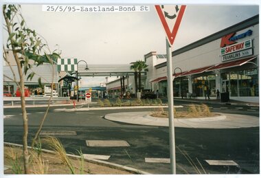
photograph, Eastlink Ringwood Bypass Construction-Eastland-Bond St 25/5/95
Colour photographWritten on back of photo: "Eastland Development-Bond St 25/5/95" -
 Ringwood and District Historical Society
Photographs, Suda and Khassa Ave Ringwood, Before and after Ringwood Bypass Construction 1993
B&W photograph taken by Ringwood Historical Research Group. Also added extract from Melways showing the roads before the Bypass (1987) showing the planned Bypass cutting these two roads, and Melways (2018) showing new alignment with Bypass11063A: 17.1.93 Suda Ave Still intact towards Maroondah Hwy. Taken near Khassa Pde 11063B: 17.1.93 Suda Ave. House gone. Near Khassa Pde 11063C: 17.1.93 Ringwood Bypass from cnr Khassa Pde and Suda Ave towards Mt Dandenong Rd 11063D: 17.2.93 Suda Ave. House gone. 11063E: 21.2.93 cnr Khassa Pde and Suda Ave. Direction of next cut for the Ringwood Bypass. Trees to go. 11063F: 21.2.93 Connection from ??? St to North end of Suda Ave 11063G: 22.2.93 Adelaide St to right (closed). Mile Ave in front and turning left. Note the grey wall along Miles St to support the new car park development. Shrub on left is in the bowling club. -
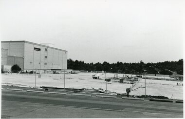 Ringwood and District Historical Society
Photographs, Eastland Car park Construction, Ringwood, 1992-93
B&W photograph taken by Ringwood Historical Research Group. Also added extract from Melways showing the roads before the Bypass (1987) showing the planned Bypass cutting these two roads, and Melways (2018) showing new alignment with Bypass11064A: 21.2.92 Eastland car park development from near Safeway 11064B: 21.2.92 Eastland car park development from Adelaide St 11064C: 4.1.93 Eastland car park development from Warrandyte Road from Op. Bond St. 11064D: 4.1.93 New Myer Eastland car park viewed from Safeway's Roof 11064E: 17.1.93 Eastland car park near where Esso Garage was 11064F: 21.2.92 Eastland car park from cnr of Adelaide St and Eastland -
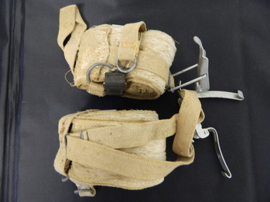 Kiewa Valley Historical Society
Ski Skins - Pair
Ski skins and webbing were introduced into the Victorian Alps by European skiers. Enthusiasts travelled to enjoy the snow and to explore the Victorian Alps including the Bogong High Plains. This equipment enabled them to travel over snow without slipping when going up hills. They took the skins off when they wanted to slide down hills. In later years waxes were used for cross country skiing and then 'fish tail' markings on the back of skis to enable skiers to travel distances up and down mountains. Later developments also included motor transport (replacing horses to get to the snow line) and roads to take skiers to the ski fields and mechanised tows to take skiers up mountains so they could ski down (downhill skiing).Skiers visited the Bogong High Plains especially during the years of the State Electricity Commission of Victoria's construction of the Kiewa Hydro Electric Scheme from the 1930's onwards. Tourists to the area increased during this time and influenced the development of Falls Creek.Long cream strips with soft short 'fur' on one side and a type of strong hessian on the back with the length of the middle and sides stitched. At one end an adjustable strap is attached to a steel, hinged clasp and at the other end is a loop that fits over the ski. A quarter of the way from each end is a steel attachment for fastening over the ski - the 'toe' end with a rubber embossed flap and the other with a short and long strap each with a steel ring at the end.On the rubber attachment: 'vinersa/pat uno'ski skins; bogong high plains; falls creek -
 Kiewa Valley Historical Society
Folder - History of Mt Beauty Township, 1980's
'The Kiewa Story' by Graham Napier requested submissions by residents of Mt Beauty for inclusion in his book. The submissions give a lot of detail and cover many subjects.An in-depth history as remembered by people who lived and worked on the Kiewa Hydro Electric Scheme from the 1940's onwards. Many lived locally in the construction towns of Mt Beauty and Bogong.A collection of papers in a white folder with submissions by locals as requested for the book "The Kiewa Story" by Graham Napier, Geoff Easdown in 1986. There is an Index and also included a note that' submissions tell the story of the community involvement in Mt Beauty's development.kiewa story; graham napier; mt beauty; kiewa hydro electric scheme; state electricity commission of victoria; communities -
 Kiewa Valley Historical Society
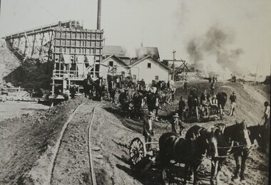
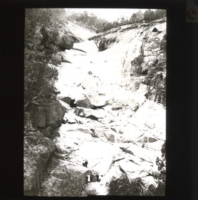
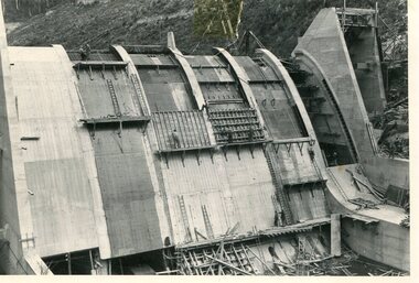
Photo - Junction Dam Construction, Circa 1940's
Junction (Lake Guy) Dam is a 'slab and buttress' type wall. A timber frame is built and then filled with concrete. The first batch of concrete was placed in September, 1940. By June, 1941 the buttresses were finished to a height safe from floods and in October of that year a flood of 2,800 cusecs occurred but with only slight damage to the installations. Industrial trouble caused some delays but there was also slow progress on the part of the contractor and the work was taken over by the S.E.C., terminating the contract. The dam was completed in March, 1944. A walkway was made through the dam wall. Lake Guy was named after Mr. L.T. Guy who was the Resident engineer, in charge of construction work and associated activities on the Kiewa Area from 1939 to November 1946Photos of the construction of the Junction Dam detail the harsh conditions faced by construction workers, building dams and villages to accommodate workers in the 1940s to the 1950s. Australia at this period in time, experienced a surge of population (influx of World War II refugees), which was the catalyst for developing and undergoing an enormous hydroelectricity program for the Alpine regions, both in Victoria and New South Wales. This program was initiated to supply electricity to the major southern Australian cities of Adelaide, Melbourne and Sydney. It was thought that these developments would reduce, if not eliminate, the requirement for coal driven power stations. However time has demonstrated that these power stations have not matched the demand required by the industries and the populations of the major urban and cities.Black and white photograph of Junction Dam constructionjunction dam, bogong, secv -
 Kiewa Valley Historical Society
Photo - Junction Dam Diversion Tunnel
Junction (Lake Guy) Dam is a 'slab and buttress' type wall. A timber frame is built and then filled with concrete. The first batch of concrete was placed in September, 1940. By June, 1941 the buttresses were finished to a height safe from floods and in October of that year a flood of 2,800 cusecs occurred but with only slight damage to the installations. Industrial trouble caused some delays but there was also slow progress on the part of the contractor and the work was taken over by the S.E.C., terminating the contract. The dam was completed in March, 1944. A walkway was made through the dam wall. Lake Guy was named after Mr. L.T. Guy who was the Resident engineer, in charge of construction work and associated activities on the Kiewa Area from 1939 to November 1946.Diversion dams are installed to raise the water level of a body of water to be redirected. The redirected water is used for hydro electric power generation. A diversion tunnel is usually bored through solid rock next to the dam site to bypass the dam construction site. The dam is built while the river flows through the diversion tunnel.Photos of the construction of the Junction Dam detail the harsh conditions faced by construction workers, building dams and villages to accommodate workers in the 1940s to the 1950s. Australia at this period in time, experienced a surge of population (influx of World War II refugees), which was the catalyst for developing and undergoing an enormous hydroelectricity program for the Alpine regions, both in Victoria and New South Wales. This program was initiated to supply electricity to the major southern Australian cities of Adelaide, Melbourne and Sydney. It was thought that these developments would reduce, if not eliminate, the requirement for coal driven power stations. However time has demonstrated that these power stations have not matched the demand required by the industries and the populations of the major urban and cities.Black and white photograph of Junction Dam diversion tunnel at Bogong VillageHandwritten on back - Junction Dam Diversional Tunnelbogong, secv, junction dam, lake guy -
 Kiewa Valley Historical Society
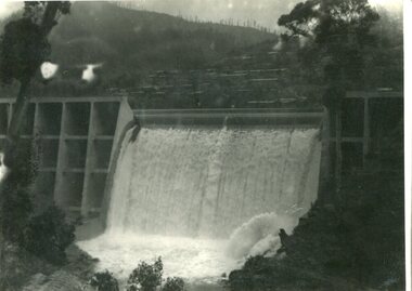
Photograph - Junction Dam spilling
Junction (Lake Guy) Dam is a 'slab and buttress' type wall. A timber frame is built and then filled with concrete. The first batch of concrete was placed in September, 1940. By June, 1941 the buttresses were finished to a height safe from floods and in October of that year a flood of 2,800 cusecs occurred but with only slight damage to the installations. Industrial trouble caused some delays but there was also slow progress on the part of the contractor and the work was taken over by the S.E.C., terminating the contract. The dam was completed in March, 1944. A walkway was made through the dam wall. Lake Guy was named after Mr. L.T. Guy who was the Resident engineer, in charge of construction work and associated activities on the Kiewa Area from 1939 to November 1946Photos of the construction of the Junction Dam detail the harsh conditions faced by construction workers, building dams and villages to accommodate workers in the 1940s to the 1950s. Australia at this period in time, experienced a surge of population (influx of World War II refugees), which was the catalyst for developing and undergoing an enormous hydroelectricity program for the Alpine regions, both in Victoria and New South Wales. This program was initiated to supply electricity to the major southern Australian cities of Adelaide, Melbourne and Sydney. It was thought that these developments would reduce, if not eliminate, the requirement for coal driven power stations. However time has demonstrated that these power stations have not matched the demand required by the industries and the populations of the major urban and cities.Black and white photograph of Junction Dam spilling at Bogong VillageHandwritten in pencil - Junction Dam spillingbogong, junction dam, lake guy, secv -
 Kiewa Valley Historical Society
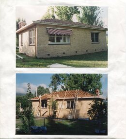
Photographs x 2 - Mount Beauty Infant Welfare Centre, February 1994
During the 1950's, Mt Beauty's population was rapidly increasing due to the post war baby boom and because there was a young workforce moving into the area due to the opportunity available for work on the construction of the Kiewa Hydro Electric Scheme. Maternal Infant Welfare Centre Sisters conducted regular check-ups on babies to ensure they were feeding well, gaining weight and reaching appropriate milestones for their age.Infants and young children in the Kiewa Valley area continue to be monitored by the Maternal Health Nurses to ensure their healthy development. The photographs are an historical record of early buildings in the Mt Beauty area, their uses and how they have changed to meet the changing needs of the community.2 x colour photographs of renovations to Mt Beauty Infant Welfare Centre. Mounted on white A4 copy paperPrinted at bottom of page underneath photos - Mt Beauty Infant Welfare Centre February 1994. Replacement of tile roof with Colourbond corrugated iron and construction of covered entry porch.mt beauty, infant welfare centre