Showing 14604 items
matching drives
-
 Port of Echuca
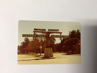
Colour Photograph, Approx.1979
In 1869 the Council moved to name this park "Victoria Park. The cricket pitch construction began in 1873 and major improvements to the ground were undertaken in 1881. It is still the primary sporting ground in Echuca, offering AFL football oval, cricket pitch and nets, athletics and entry to the Echuca boat ramp and the natural bush land of the scenic drive. It also houses Echuca Council caravan park. The signage in this photograph is no longer there and the enterance to the caravan park has moved.This area of Echuca has historically been a major recreational area for the town. Being the primary sporting ground since its establishment in 1869., the area has a number of sporting and recreational facilities for the people of Campaspe Shire, from natural bush walks in and along the Murray river to more formal facilities such as AFL football ground, firefighting training area, netball courts, cricket pitch and nets, and grass tennis courts. Colour photograph (post-card size) of directory signs to entrance of Victoria Park, Echuca taken facing north. Two driveways are shown, to the east "Caravan Park" and to the west , "Victoria Park", "Boat ramp", " Scenic drive"Printed in black on the reverse:"this paper manufactured by Kodak"echuca, port of, echuca council caravan park, victoria park, echuca, echuca-tourist attraction -
 Federation University Historical Collection
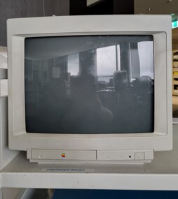
Equipment - Computer, monitor and keyboard, Apple IIe Computer c1983
Apple IIe complete computer system from Mount Helen Campus Nursing Co-hort. Complete Apple IIe Computer - monitor, keyboard, mouse and disk drive 22456.1 Monitor 22456.2 keyboard, spare keyboard, mouse and disc drive.Apple IIe computer, mount helen campus, apple iie, bachelor of nursing -
 Rutherglen Historical Society
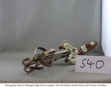
Egg beater, Propert Production, c1930
Owned and used by Mrs Daisy ParkinRotary egg beater with a patent ball driveSwift Whip, Propert Productionkitchenware -
 Hand Tool Preservation Association of Australia Inc
Chart
This item is part of the Thomas Caine Tool Collection, owned by The National Trust of Australia (Victoria) and curated by the Hand Tools Preservation Association of Australia.Chart, lathe drive & driven wheel ratios -
Vision Australia
Audio - Sound recording, Brian Crozier International, Steps in the Right Direction: Jenny Scown - move to Coorparoo, 12/7/2010
Jenny Scown, team leader at Business Enterprises at Coorparoo, talks about she became blind and her journey through life including the move to the new office at Coorparoo.1 wmv file stored on hard drivevision australia, jenny scown, coorparoo, oral history -
 Ringwood and District Historical Society
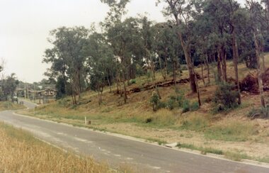
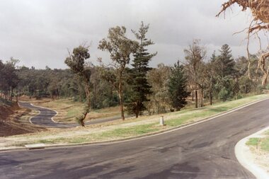
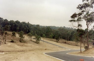
Photograph, Looking south up Werac Drive, North Ringwood past Manuelo Drive in February 1979
E552 N21 Part of a 51-photo record of the development of the "Kubis" Estate, Ringwood North, including road works to Debbie Place, Kubis Drive, Werac Drive, Manuelo Drive, Iluka Place and Glenvale Road. From the Jack Lundy Clarke collection. -
 Ringwood and District Historical Society
Photograph, Looking north down Werac Drive, North Ringwood with lake headwater's site behind light standard on left in February 1979
B552 N19 Part of a 51-photo record of the development of the "Kubis" Estate, Ringwood North, including road works to Debbie Place, Kubis Drive, Werac Drive, Manuelo Drive, Iluka Place and Glenvale Road. From the Jack Lundy Clarke collection. -
 Ringwood and District Historical Society
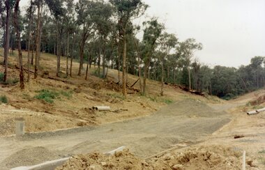
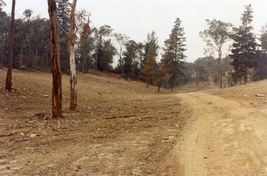
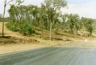
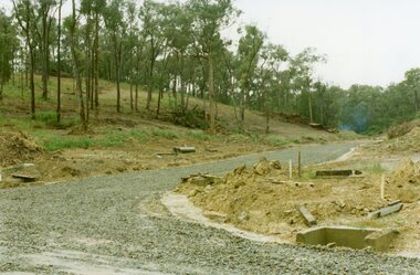
Photograph, The unfinished section of Debbie Place, North Ringwood in February 1979
E552 N23 Part of a 51-photo record of the development of the "Kubis" Estate, Ringwood North, including road works to Debbie Place, Kubis Drive, Werac Drive, Manuelo Drive, Iluka Place and Glenvale Road. From the Jack Lundy Clarke collection. -
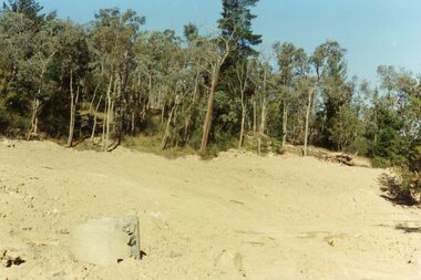
 Ringwood and District Historical Society
Photograph, Site of the main body of Loughnan's Lake, North Ringwood on 10 June 1978. the rope tree was on the slope, far left
E550 N6 Part of a 51-photo record of the development of the "Kubis" Estate, Ringwood North, including road works to Debbie Place, Kubis Drive, Werac Drive, Manuelo Drive, Iluka Place and Glenvale Road. From the Jack Lundy Clarke collection. -
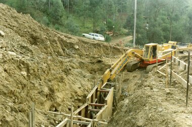
 Ringwood and District Historical Society
Photograph, Kubis Estate, North Ringwood on 16 June 1978, using the Kato as a crne to de-water final trench
E550 N9 Part of a 51-photo record of the development of the "Kubis" Estate, Ringwood North, including road works to Debbie Place, Kubis Drive, Werac Drive, Manuelo Drive, Iluka Place and Glenvale Road. From the Jack Lundy Clarke collection. -
 Ringwood and District Historical Society
Photograph, Kubis Estate, North Ringwood on 10 June 1978. Temporary end of Kubis Drive at junction with Debbie Place. The car stands at junction with Pamela Place
E550 N8 Part of a 51-photo record of the development of the "Kubis" Estate, Ringwood North, including road works to Debbie Place, Kubis Drive, Werac Drive, Manuelo Drive, Iluka Place and Glenvale Road. From the Jack Lundy Clarke collection. -
 Ringwood and District Historical Society
Photograph, Kubis Estate, North Ringwood on 16 June 1978. The Kato lifts a bucket out of the trench
E550 N11 Part of a 51-photo record of the development of the "Kubis" Estate, Ringwood North, including road works to Debbie Place, Kubis Drive, Werac Drive, Manuelo Drive, Iluka Place and Glenvale Road. From the Jack Lundy Clarke collection. -
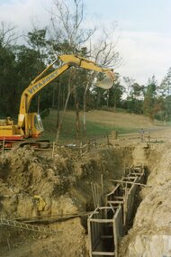
 Ringwood and District Historical Society
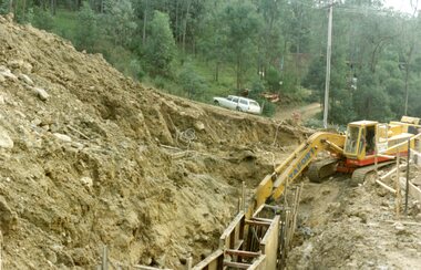
Photograph, Kubis Estate, North Ringwood on 16 June 1978. The concrete wall 27 feet deep at the pumping station in Glenvale Road
E550 N12 Part of a 51-photo record of the development of the "Kubis" Estate, Ringwood North, including road works to Debbie Place, Kubis Drive, Werac Drive, Manuelo Drive, Iluka Place and Glenvale Road. From the Jack Lundy Clarke collection. -
 Ringwood and District Historical Society
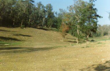
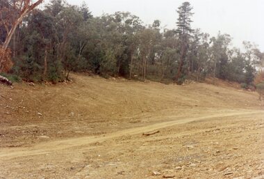
Photograph, Kubis Estate, North Ringwood in February 1978. The site of Loughnan's Lake seen from the north end of the wall. The rope tree was on the hillside on the left
E546 N2 Part of a 51-photo record of the development of the "Kubis" Estate, Ringwood North, including road works to Debbie Place, Kubis Drive, Werac Drive, Manuelo Drive, Iluka Place and Glenvale Road. From the Jack Lundy Clarke collection. -
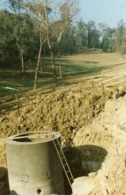
 Ringwood and District Historical Society
Photograph, Kubis Estate, North Ringwood on 16 June 1978. Kato working on final trench. The hole for the 27 feet deep well is seen beyond the trench
E550 N10 Part of a 51-photo record of the development of the "Kubis" Estate, Ringwood North, including road works to Debbie Place, Kubis Drive, Werac Drive, Manuelo Drive, Iluka Place and Glenvale Road. From the Jack Lundy Clarke collection. -
 Ringwood and District Historical Society
Photograph, Kubis Estate, North Ringwood in April 1978. View east up Kubis Drive from Jenkin Close past the foot of Werac Drive
E549 N16 Part of a 51-photo record of the development of the "Kubis" Estate, Ringwood North, including road works to Debbie Place, Kubis Drive, Werac Drive, Manuelo Drive, Iluka Place and Glenvale Road. From the Jack Lundy Clarke collection. -
 Ringwood and District Historical Society
Photograph, Kubis Estate, North Ringwood in April 1978. View east up Kubis Drive over Jenkin Close and intersection with Werac Drive
E549 N18 Part of a 51-photo record of the development of the "Kubis" Estate, Ringwood North, including road works to Debbie Place, Kubis Drive, Werac Drive, Manuelo Drive, Iluka Place and Glenvale Road. From the Jack Lundy Clarke collection. -
 Ringwood and District Historical Society
Photograph, Kubis Estate, North Ringwood in April 1978. Looking up the hill in Kubis Drive from the site of headwaters of Loughnan's Lake. Jenkins Close takes off to the right from centre
E548 N31 Part of a 51-photo record of the development of the "Kubis" Estate, Ringwood North, including road works to Debbie Place, Kubis Drive, Werac Drive, Manuelo Drive, Iluka Place and Glenvale Road. From the Jack Lundy Clarke collection. -
 Ringwood and District Historical Society
Photograph, Kubis Estate, North Ringwood in April 1978. Looking upstream from below the retaining wall of Loughnan's Lake that was where the truck tracks disappear. The wall was extended to the left across what was then a small gorge
E548 N19 Part of a 51-photo record of the development of the "Kubis" Estate, Ringwood North, including road works to Debbie Place, Kubis Drive, Werac Drive, Manuelo Drive, Iluka Place and Glenvale Road. From the Jack Lundy Clarke collection. -
 Ringwood and District Historical Society
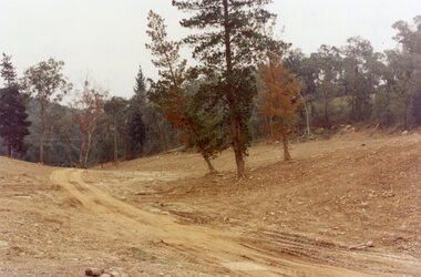
Photograph, Kubis Estate, North Ringwood in April 1978. Looking west over site of Loughnan's Lake. The rope tree was on the slope to the right beyond the ridge with the lone pine
E548 N15 Part of a 51-photo record of the development of the "Kubis" Estate, Ringwood North, including road works to Debbie Place, Kubis Drive, Werac Drive, Manuelo Drive, Iluka Place and Glenvale Road. From the Jack Lundy Clarke collection. -
 Ringwood and District Historical Society
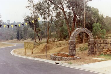
Photograph, Werac Drive, North Ringwood, entrance to Bel-Air Country Club in April 1978
E548 N11 Part of a 51-photo record of the development of the "Kubis" Estate, Ringwood North, including road works to Debbie Place, Kubis Drive, Werac Drive, Manuelo Drive, Iluka Place and Glenvale Road. From the Jack Lundy Clarke collection. -
 Ringwood and District Historical Society
Photograph, Loughnan Lake site over Kubis Drive, North Ringwood, on 14 April 1978. The retaining wall was where the car tracks disappear over the ridge where the spillway was
E548 N13 Part of a 51-photo record of the development of the "Kubis" Estate, Ringwood North, including road works to Debbie Place, Kubis Drive, Werac Drive, Manuelo Drive, Iluka Place and Glenvale Road. From the Jack Lundy Clarke collection. -
 Ringwood and District Historical Society
Photograph, "Kubis Estate", North Ringwood, in April 1978. Looking north-east over Loughnan's Lake greatest width. The rope tree was on the slope in the centre. The spillway was on the near left of the image
E548 N17 Part of a 51-photo record of the development of the "Kubis" Estate, Ringwood North, including road works to Debbie Place, Kubis Drive, Werac Drive, Manuelo Drive, Iluka Place and Glenvale Road. From the Jack Lundy Clarke collection. -
 Ringwood and District Historical Society
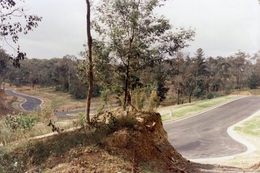
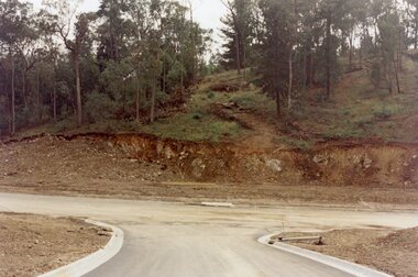
Photograph, Junction of Kubis Drive and Iluka Court, North Ringwood, in February 1979. Looking south with Hubbard Reserve beyond
E552 N25 Part of a 51-photo record of the development of the "Kubis" Estate, Ringwood North, including road works to Debbie Place, Kubis Drive, Werac Drive, Manuelo Drive, Iluka Place and Glenvale Road. From the Jack Lundy Clarke collection. -
 Ringwood and District Historical Society
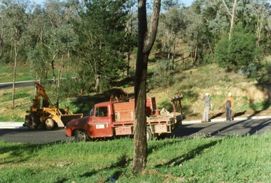
Photograph, The Telecom gang laying pipes in Kubis Drive, North Ringwood, near Jenkins Close, on 10th June 1978
E550 N5 Part of a 51-photo record of the development of the "Kubis" Estate, Ringwood North, including road works to Debbie Place, Kubis Drive, Werac Drive, Manuelo Drive, Iluka Place and Glenvale Road. From the Jack Lundy Clarke collection. -
 Ringwood and District Historical Society
Photograph, Corner of Pamela Court and Kubis Drive, North Ringwood, looking west on 3rd November 1978
E551 N15 Part of a 51-photo record of the development of the "Kubis" Estate, Ringwood North, including road works to Debbie Place, Kubis Drive, Werac Drive, Manuelo Drive, Iluka Place and Glenvale Road. From the Jack Lundy Clarke collection. -
 Ringwood and District Historical Society
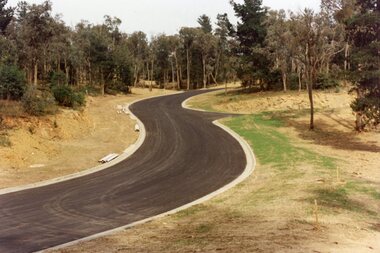
Photograph, Kubis Drive and Debbie Place, North Ringwood, on 3rd November 1978, looking east
E551 N13 Part of a 51-photo record of the development of the "Kubis" Estate, Ringwood North, including road works to Debbie Place, Kubis Drive, Werac Drive, Manuelo Drive, Iluka Place and Glenvale Road. From the Jack Lundy Clarke collection.51 -
 Ringwood and District Historical Society
Photograph, Looking from Werac Drive, North Ringwood, on 14th April 1978, across the site of the headwaters of Loughnan's Lake. Main body of water lay to the left (west)
E548 N7 Part of a 51-photo record of the development of the "Kubis" Estate, Ringwood North, including road works to Debbie Place, Kubis Drive, Werac Drive, Manuelo Drive, Iluka Place and Glenvale Road. From the Jack Lundy Clarke collection.51 -
 Ringwood and District Historical Society
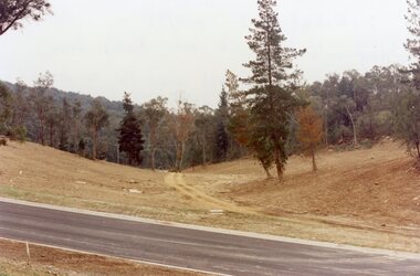
Photograph, Looking west from Kubis Drive, North Ringwood, in April 1978, over the full length of the site of Loughnan's Lake
E548 N5 Part of a 51-photo record of the development of the "Kubis" Estate, Ringwood North, including road works to Debbie Place, Kubis Drive, Werac Drive, Manuelo Drive, Iluka Place and Glenvale Road. From the Jack Lundy Clarke collection.51 -
 Ringwood and District Historical Society
Photograph, Looking up Debbie Place, North Ringwood, on 3rd November 1978, that has box sheet of metal
E551 N14 Part of a 51-photo record of the development of the "Kubis" Estate, Ringwood North, including road works to Debbie Place, Kubis Drive, Werac Drive, Manuelo Drive, Iluka Place and Glenvale Road. From the Jack Lundy Clarke collection.51