Showing 1938 items
matching flood
-
 Orbost & District Historical Society
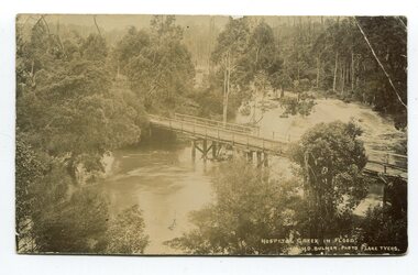
black and white photograph / postcard, Early 20th century - pre 1906?
This photograph shows the Hospital Creek in flood. This is a pictorial record of a bridge in East Gippsland in the early 20th century.A black / white photograph / postcard of a road bridge across a flooded creek. It is in a bush setting.in front at bottom - "Hospital Creek in flood H.D.Bulmer photo Lake Tyers"bridge-hospital-creek tostaree-bridge -
 Charlton Golden Grains Museum Inc
Photograph
Flooded Billabong Cadgow's Dairy in the bend of the Avoca River Oct 1975Black and white photograph of flooded billabong.flood, charlton -
 Lakes Entrance Historical Society
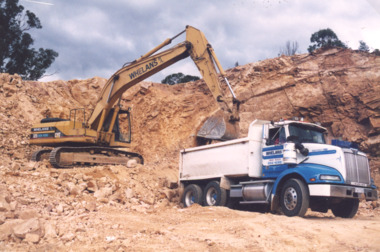
Photograph, Lakes Post Newspaper, flood response program 1998,Tambo Valley East Gippsland Victoria, 1/06/1999 12:00:00 AM
Colour photograph of Whelans truck being loaded with rock and gravel during flood response program in the Tambo Valley East Gippsland Victoriafloods, natural disasters -
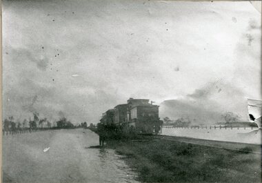
 Orbost & District Historical Society
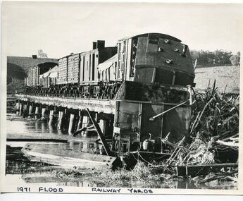
black and white photograph, February 1971
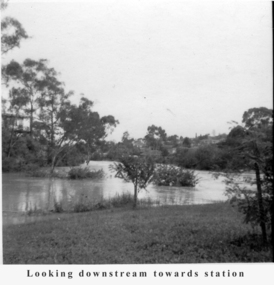
The 1971 flood was the the worst flood on record. At Jarrahmond it was at least 11 metres and up to one and a half kilometres wide on the flats causing enormous damage to the flood plain. Records say that "The brown floodwater stain in Bass Strait could be seen from passing airliners." Considerable damage was done to railway infrastructure, roads and farms. More information from the APRIL, 2008 newsletter by John Phillips. (see orbosthistory.com.au) The railway line was destroyed and was not expected to be opened for a fortnight. Orbost was cut off by 50 square miles of Snowy River floodwater. This train was being shunted across the viaduct when waters smashed through washing away several trucks sending the crew running for their lives.This is pictorial evidence of a significant local event. It is connected to the history of the railway in East Gippsland.A large black / white photograph of flooded railway yards with a train engine stranded on a small section of track surrounded by water and debris.on front - "1971 Flood, Railway Yards"floods-1971-orbost orbost-railway natural-disasters-orbost -
 Clunes Museum
Photograph, HORNBY STUDIO - CLUNES, FLOOD 1909, August 1909
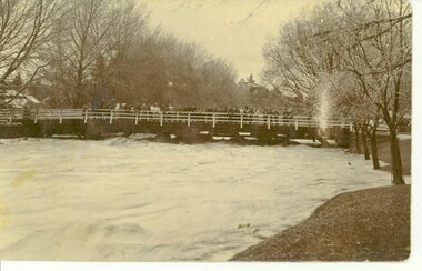
SEPIA PHOTOGRAPH OF SERVICE STREET BRIDGE IN CLUNES. TAKEN IN AUGUST 1909 WHEN CREEK WAS IN FLOOD. TREES ON CREEK BANK, MANY PEOPLE ARE STANDING ON BRIDGE.photographs, bridges, service street bridge -
 Kew Historical Society Inc
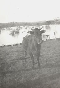
Photograph, Cattle in North Kew floods, 1934
The year 1934 witnessed the greatest flooding of the Yarra River since settlement. This work forms part of the collection assembled by the historian Dorothy Rogers, that was donated to the Kew Historical Society by her son John Rogers in 2015. The manuscripts, photographs, maps, and documents were sourced by her from both family and local collections or produced as references for her print publications. Many were directly used by Rogers in writing ‘Lovely Old Homes of Kew’ (1961) and 'A History of Kew' (1973), or the numerous articles on local history that she produced for suburban newspapers. Most of the photographs in the collection include detailed annotations in her hand. The Rogers Collection provides a comprehensive insight into the working habits of a historian in the 1960s and 1970s. Together it forms the largest privately-donated collection within the archives of the Kew Historical Society.Photograph of floodwaters encroaching on farm land in North Kew in the flood of 1934.Nth. Kew. 1934 Floodsfloods (melbourne) 1934, dorothy rogers -
 Greensborough Historical Society
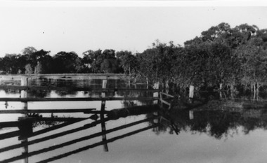
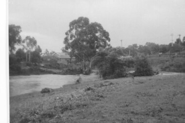
Photograph - Digital image, Plenty River in flood 1972 at Rand Street crossing (3), 1972_
Plenty River in flood Greensborough 1972. There were two major floods in Greensborough at the time, 1972 and 1974. Poulter Reserve was created after the 1972 flood and had to be re-established following the 1974 flood.Digital copy of black and white photograph.plenty river, floods -
 Greensborough Historical Society
Photograph - Digital Image, Aftermath of Plenty River flood 1972 in Poulter Reserve. (4), 1972_
Plenty River in flood around the Poulter Reserve. There were two major floods in Greensborough at the time, 1972 and 1974. Poulter Reserve was created after the 1972 flood and had to be re-established following the 1974 flood.Digital copy of black and white photograph.plenty river, floods -
 Greensborough Historical Society
Photograph - Digital Image, Plenty River in flood 1972, view at the Rand Street Crossing, 1972_
Plenty River in flood at the Rand Street Crossing. There were two major floods in Greensborough at the time, 1972 and 1974. Poulter Reserve was created after the 1972 flood and had to be re-established following the 1974 flood.Digital copy of black and white photograph.plenty river, floods -
 Greensborough Historical Society
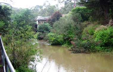
Photograph - Digital image, Plenty River in Flood 2017: The River, 14/12/2017
3 photographs of the Plenty River in flood, Greensborough. This flood was in December 2017.Digital copy of 3 colour photographs.plenty river, floods -
 Greensborough Historical Society
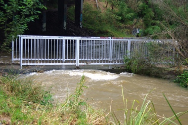
Photograph - Digital image, Plenty River in Flood 2017: The Footbridge, 14/12/2017
3 photographs of the Plenty River in flood, Greensborough. This flood was in December 2017.Digital copy of 3 colour photographs.plenty river, floods -
 Charlton Golden Grains Museum Inc
Photograph, Barber, Mr, c. 1933
1933 Flood, in Armstrong Street, Mr Barber and dog in boat.1933 flood in Armstrong Street. Mr Barber and dog in boat.flood, charlton -
 Tatura Irrigation & Wartime Camps Museum
Photograph - original, Kodak, Tatura Floods 1950's, 1950's original
Original photograph of flooded street and shops, Hogan Street Tatura, 1955Original sepia photograph of part of Hogan Street Tatura, under flood c 1950'son back: Hogan Street Tatura under floods c early 1950's -
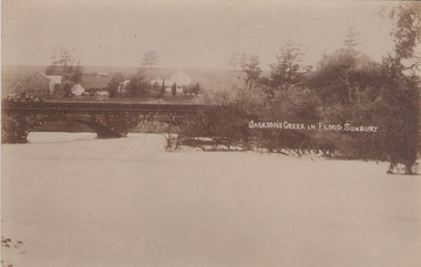 Sunbury Family History and Heritage Society Inc.
Photograph
The post card is a record of a time when the Jacksons Creek flooded and the water almost reached the two arches on the Macedon Street Bridge. The Goonawarra Winery buildings can be seen in the back ground.A sepia photograph in post card format of a river in flood with the water almost reaching the two arches on the stone bridge. Farm buildings can be seen in the middle distance.JACKSON'S CREEK IN FLOOD SUNBURYmacedon street bridge, jacksons creek, goonawarra winery -
 Greensborough Historical Society
Photograph - Digital Image, Plenty River in flood 1972 (1), 1972_
Plenty River in flood near Greensborough. There were two major floods in Greensborough at the time, 1972 and 1974.Digital copy of black and white photograph.plenty river, floods -
 Greensborough Historical Society
Photograph - Digital Image, Plenty River in flood 1972 Flintoff Street Crossing (2), 1972_
Plenty River in flood, circa 1972. There were two major floods in Greensborough at the time, 1972 and 1974.Digital copy of black and white photograph.plenty river, floods -
 Greensborough Historical Society
Photograph - Digital Image, Plenty River Flood 1972, 1972_
The Plenty River in flood, Greensborough circa 1972. There were two major floods in Greensborough at the time, 1972 and 1974.Digital copy of black and white photograph.plenty river, floods -
 Greensborough Historical Society
Photograph - Digital Image, Plenty River in Flood, 1974_
5 photographs of the Plenty River in flood, Greensborough. There were two major floods in Greensborough at the time, 1972 and 1974.Digital copy of 5 black and white photographs.plenty river, floods -
 Kew Historical Society Inc
Photograph, Marnie McLeod, Floods of the River Yarra at Kew, 1916
The donation was accompanied by the following letter from the donor: "Hi. I found these in with family photos. Taken by family as Mamie McLeod was living in Fellows Street, Kew, so would be near there. Retain (or discard) as you see fit." [Donor's name and address withheld from public view]. To gain an insight into the flood levels at Kew, it is worth reading newspaper accounts of the event. The Age published an article - Valuable Gardens Destroyed at Kew - on 25 September 1916: "VALUABLE GARDENS DESTROYED AT KEW. From the heights of Studley Park, Kew, a splendid view of the flood waters can be obtained, and yesterday afternoon, despite continuous rain, crowds of citizens assembled there to witness the spectacle. There is a vast stretch of water some 300 or 400 yards broad, above the foot bridge connecting Gipps-street, Collingwood, and Studley Park. The river is only about 3 feet from the top of the embankment connecting with the ramp of the bridge on the Studiey Park side. When the upper llood waters come down it is almost a certainty that tne embankment will be submerged and the bridge rendered impassible. Below the bridge the waters again stretch out, and have submerged all the low-lying land on the Collingwood side and invaded the back premises ot the Kodak Co., Phoenix Biscuit Factory, a tannery adjoining thereto, the Shamrock Brewery, and Chinese gardens in the vicinity. At Walmer-street-bridge, at the end of Studley Park, the low-lying land on the Kew side is covered with water to the depth of many feet. Tlie land in question is owned in a great part by Mr Frank Lavers who haa gone in for intense culture on a pretty liberal scale on both the slopes of the hill and on the river flat. On the latter he is cultivating many acres of asparagus, and has at a considerable cost spent three years in preparing the ground and installing an irrigation system, reticulated from the Yan Yean water supply. This year the asparagus was put down, and the plants were in a promising condition. Tlie flood waters are now flowing fast over the land. The crop is ruined, and three years' work and expenditure destroyed. Mr. Laver's private residence fortunately is high above flood level, but two houses he owns off Young-street have been flooded out. Having been warned in time, the tenants removed their furniture hefore the water came down to Mr. Laver's residence, where they themselves have been given accommodation in the meantime. All the river flats in East Kew are under water. One or two low-lying houses have been flooded. Chipperfield's boat shed at Willsmere is nearly covered, and some Chinese gardens in the vicinity are several feet under water."This, and the other three photographs donated of floods in Kew are believed to be the earliest in the collection. Together with our original MMBW River Yarra map showing flood levels, these items, when compared allow researchers to gain a visual perspective of the extent of the flood in 1916. Black and white photograph of flooded trees in Kew with rising dry ground in distance.Inscription on reverse in pencil: "Flood River Yarra Kew Vic"river yarra, kew, floods 1916 -
 Eltham District Historical Society Inc
Photograph, Fay Bridge, Flood damage at Nillumbik Medical Centre, 1078 Main Road, Eltham, 26 December 2011
Flood damage resulting from a late afternoon storm on Christmas Day 2011. A flash flood occurred from significant rain fall and hail, which accumulated along an old waterway with floodwater submerging cars along Valonia Drive then down Grove Street flooding houses, through the Bible Street Reserve where it then submerged Main Road washing away the small railway trestle bridge opposite the reserve then flooding the Judge Book Village before finally entering the Diamond Creek..fay bridge collection, 2011-12-26, bible street reserve, flood damage, floods, floodwater, main road, nillumbik medical centre -
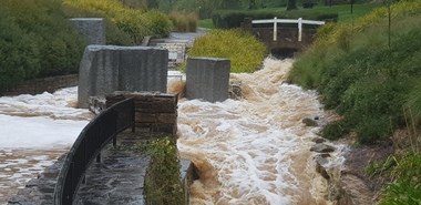 Ballarat Heritage Services
Photograph - Hepburn Mineral Springs flood 13 Oct 2022, LJ Gervasoni, Springs in flood 2022, 13 October 2022
October 2022 floodsjpg photolocarno, hepburn mineral springs reserve, wild cat creek -
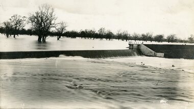 Stawell Historical Society Inc
Photograph, Lake Lonsdale Weir in Flood
Lake Lonsdale Weir in Floodstawell -
Clunes Museum
Flyer, Victorian Government, FLOOD RECOVERY COMMUNITIES AND THE ENVIRONMENT, C 2012
FLOOD RECOVERY COMMUNITIES AND ENVIRONMENTA4 DOUBLE SIDED FLYER FROM NORTH CENTRAL CATCHMENT MANAGEMENT AUTHORITY (NCCMA). COLOUR PHOTOS AND TEXT ON FRONT AND MAP OF AFFECTED AREAS ON THE BACK.nccma, flood recovery -
 Stawell Historical Society Inc
Photograph, Railway Flood Scene at Lubeck 1909
Railway Flood Scene at Lubeck 1909stawell transport -
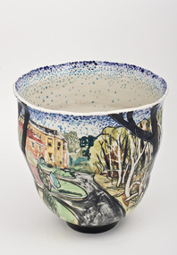 Nillumbik Shire Council
Ceramics (vase): Chris PITTARD, Chris Pittard, Vessel - Flood, 2006
Chris Pittard is a painter who has been working with clay for over 15 years. Pittard studied Fine Arts at RMIT and VCA and has exhibited paintings for a number of years. Pittard divides his time between teaching, drawing and painting and working in the ceramics studio where he creates distinctive pieces. Chris Pittard's ceramic pieces translate the narrative to the vessel. His vessels speak to us about our place and even his personal stories become more universal expressions.In early 2005 there was a flood which raged through the creeks cutting through the Shire of Nillumbik (Eltham). Not usually affected by catastrophe, these surging waters destroyed bridges and threatened roads. When the water subsided along the banks of the creek, trees had fallen, flotsam and jetsam piled up and even weeks later the long grass flattened by the flood continued to map the raging waters flow. The combination of slightly threatening and destructive forces and eerie beauty interested me. This at a time when world events of a far more horrific and tragic nature where presented to us by strangely beautiful coloured photos in our daily papers. These connections may not be obvious but it was certainly something I was thinking about while making this ceramic piece.flood, chris pittard, eltham, nillumbik -
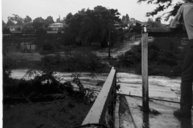
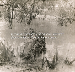 Eltham District Historical Society Inc
Photograph, George W. Bell, Flood Eltham, 1960s
Diamond Creek in flood at Eltham c.1960sBlack and white printfloods, eltham, diamond creek, george w bell collection -
 Greensborough Historical Society
Photograph - Photograph (Copy), Anne Paul, Plenty River in flood 2003, Lower Plenty, 2003_12
Two views of Plenty River in flood, Lower Plenty.2 colour photographs printed on paper, handwritten captionslower plenty, plenty river, floods -
 Greensborough Historical Society
Photograph - Digital Image, Tony Fitton, Plenty River flood 1960s, 1960s
The Plenty River in flood, 1960s. Photos taken by Tony Fitton. Digital copy of black and white photographs.Captions on imageplenty river, floods -
 Stawell Historical Society Inc
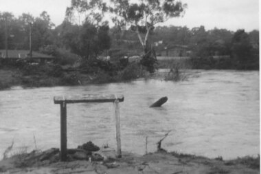
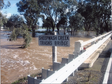
Photograph, Trasks Bridge at Sheepwash Creek at Campbells Bridge in flood 2011
Trasks Bridge Sheepwash Creek at Campbells Bridge in flood 2011.stawell shire -
 Lakes Entrance Historical Society
Photograph, Bulmer Street in flood Lakes Entrance Victoria, 2004 c
Colour photograph showing flood water in Bulmer Street looking south towards the Cunninghame Arm Lakes Entrance Victoria. Also second colour photograph taken at same time plus another of a house under construction following a mini tornado in 2005floods, naturalm disasters, township