Showing 191 items
matching hustler's reef
-
 Bendigo Historical Society Inc.
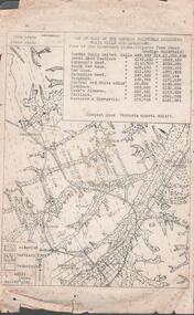
Map - STRUGNELL COLLECTION: HUSTLER'S LINE OF REEFS, BENDIGO, September 1913
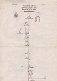
... Map, Hustler's Line of Reefs, Fortuna Hustler's Mine.... Map, Hustler's Line of Reefs, Fortuna Hustler's Mine, Bendigo ...Map, Hustler's Line of Reefs, Fortuna Hustler's Mine, Bendigo, Transverse Section. Plate Mo.111(3).Bulletin No 33 Signed H.A.Whitelaw. Drawing shows the vertical shaft descending to over 2228 feet and appears to show samples of connecting horizontal shafts with their respective mineral contentsUnderground Survey Office, Bendigo.map, bendigo, fortuna hustler's mine -
 Bendigo Historical Society Inc.
Book - LONG GULLY HISTORY GROUP COLLECTION: 150 YEARS OF GOLD
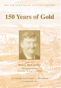
... of a wood engraving of Hustlers Reef, Sandhurst with a tan tone..., inside and out has a beige copy of a wood engraving of Hustlers ...Book titled 150 Years of Gold delivered by Peter McCarthy, Managing Director Australian Mining Consultants at La Trobe University, Bendigo on 26 September, 2001, the 2001 Sir John Quick Bendigo Lecture. Book cover, inside and out has a beige copy of a wood engraving of Hustlers Reef, Sandhurst with a tan tone photo of Peter McCarthy on the centre front. Mining is mentioned from the late 1840s to the present day. In the back is a career history of Peter McCarthy and a short life story of Sir John Quick. Also in the back is a list of past lectures from 1994 to 2000.bendigo, history, long gully history group, the long gully history group - 150 years of gold, peter mccarthy, australian mining consultants, la trobe university bendigo, robertson hyetts, sir john quick, quick hyett and rymer, quick and hyett, national library of australia, charles joseph la trobe, james gumm, hargreaves, melbourne argus, henry frenchham, the times, gibbons, james esmond, dr barker, thomas hiscock, alfred clarke, geelong advertiser, wat tyler, dunlop and regan, commissioner doveton, sub commissioner armstrong, captain dana, argus, armstrong, stewart gibson, margaret kennedy, convict's prevention act, micky o'halloran, throckmorton, anti-gold-license association, g e thomson, dr jones, 'captain' edward brown, eureka rebellion, sir john quick, mark twain, australian federation, mining exchanges, alfred deakin, the amalgamated miner's association, robert clark, britian's national miners' association, silicosis, tuberculosis, walter summons, bendigo amalgamated mines, great war, gold mines of australia, bendigo mines limited, nell gwynne, carshalton shaft, napoleon shaft, george lansell, fortuna villa, the four deborah mines, world war two, central deborah, north deborah, william kelly, the edwards works, newstead dredge, jim crow dredge, adelong dredge, calder freeway, bendigo mining nl, randolph bedford, cra ltd, sovereign hill, ballarat historical park association, rmit, melbourne university, macquarie university, australasian institute of mining and metallurgy, institution of engineers australia, mineral industry consultants association, joint ore reserves committee, ceo institute, anthea mccarthy, michele matthews, sir john quick committee, city of greater bendigo, the hon justice michael kirby, mr don blackmore, murray darling basin commission, dr janet mccalman, australian research council, dr john white, visy industries, dr al luloff, mrs delys sargeant, the rt hon ninian stephen -
 Bendigo Historical Society Inc.
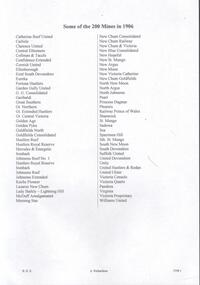
Document - BENDIGO MINES 1906
... , Garden Gully United, South New Moon, Hustlers Reef and Catherine... Virginia Victoria Proprietory Williams United Hustlers Reef ...Handwritten notes mentioning Bendigo Mines. Four mines, Garden Gully United, South New Moon, Hustlers Reef and Catherine Reef United have some information about them. Others listed are: Catherine Reef United, Carlisle, Clarence United, Central Ellesmere, Collman & Tacchi, Confidence Extended Cornish United, Ellenborough, Extd South Devonshire, Eureka, Fortuna Hustlers, Garden Gully United, G G Consolidated, Geribaldi, Great Southern, Gt Northern, Gt Extended Hustlers, Gt Central Victoria, Golden Age, Golden Pyke, Goldfields North, Goldfields Consolidated, North Johnsons, Pearl, Princess Dagmar, Phoenix, Railway Prince of Wales, Shamrock, St Mungo, Sadowa, Sea, Specimen Hill Sth St Mungo, South New Moon, South Devonshire, Suffolk United, United Devonshire, Unity, United Hustlers & Redan, United Ulster, Victoria Consols, Victoria Quartz, Pansora, Virginia, Victoria Proprietory, Williams United, Hustlers Reef, Hustlers Royal Reserve, Hercules & Energetic, Ironbark, Johnsons Reef No 1, Hustlers Royal Reserve, Ironbark, Johnsons Reef, Johnsons Extended, Kochs Pioneer, Lazarus New Chum, Lady Barkly - Lightning Hill, McDuff Amalgamated, Morning Star, New Chum Consolidated, New Chum Railway, New Chum & Victoria, New Blue Consolidated, New Hopefu, New St Mungo, New Argus, New Moon, New Victoria Catherine, New Chum Goldfields, North New Moon and North Argus. Document from Albert Richardson Collection of mining history.document, gold, bendigo mines 1906, bendigo mines 1906, catherine reef united, carlisle, clarence united, central ellesmere, collman & tacchi, confidence extended cornish united, ellenborough, extd south devonshire, eureka, fortuna hustlers, garden gully united, g g consolidated, geribaldi, great southern, gt northern, gt extended hustlers, gt central victoria, golden age, golden pyke, goldfields north, goldfields consolidated, north johnsons, pearl, princess dagmar, phoenix, railway prince of wales, shamrock, st mungo, sadowa, sea, specimen hill sth st mungo, south new moon, south devonshire, suffolk united, united devonshire, unity, united hustlers & redan, united ulster, victoria consols, victoria quartz, pansora, virginia, victoria proprietory, williams united, hustlers reef, hustlers royal reserve, hercules & energetic, ironbark, johnsons reef no 1, hustlers royal reserve, ironbark, johnsons reef, johnsons extended, kochs pioneer, lazarus new chum, lady barkly - lightning hill, mcduff amalgamated, morning star, new chum consolidated, new chum railway, new chum & victoria, new blue consolidated, new hopefu, new st mungo, new argus, new moon, new victoria catherine, new chum goldfields, north new moon, north argus, bgo library 'healthy golden bendigo' - 1906 -
 Bendigo Historical Society Inc.
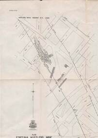
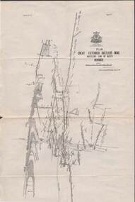
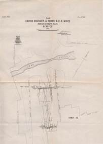
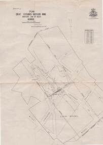
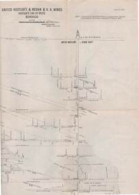
Map - UNITED HUSTLER'S & REDAN & K. K. MINES - PLAN OF UNITED HUSTLER'S & REDAN & K. K. MINES
... on the Hustler's Line of Reefs Bulletin No 33 Plate No XXVII. Plan shows... Long Gully Hustler's Line of Reefs Lightning Hill Line of Reefs ...Plan of the United Hustler's & Redan & K. K. Mines on the Hustler's Line of Reefs Bulletin No 33 Plate No XXVII. Plan shows depth of levels, Long Gully, Hustler's Line of Reefs, Lightning Hill Line of Reefs and approximate Boundary of Lease. Also mentions Comet Co. Geological Survey of Victoria emblem and signed by H S Whitelaw, Underground Survey Office Bendigo September 1913.mining, parish map, united hustler's & redan & k. k. mines, long gully, hustler's line of reefs, lightning hill line of reefs, comet co, h s whitelaw, geological survey of victoria, underground survey office -
 Bendigo Historical Society Inc.
Map - STRUGNELL COLLECTION: HUSTLER'S LINE OF REEFS, BENDIGO, September 1913
... Map, Hustler's Line of Reefs, Bendigo, Plan Fortuna.... Map, Hustler's Line of Reefs, Bendigo, Plan Fortuna Hustler's ...Map, Hustler's Line of Reefs, Bendigo, Plan Fortuna Hustler's Mine, Hustler's Royal Reserve No. 2 Lease. Plate No.1(1) Bulletin No 33 Signed H.A.Whitelaw.Underground Survey Office, Bendigo.map, bendigo, fortuna hustler's mine -
 Bendigo Historical Society Inc.
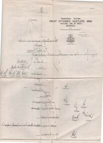
Map - STRUGNELL COLLECTION: HUSTLER'S LINE OF REEFS, BENDIGO, September 1913
... Map, Hustler's Line of Reefs, Great Extended Hustler's Mine..., Bendigo. Map, Hustler's Line of Reefs, Great Extended Hustler's ...Map, Hustler's Line of Reefs, Great Extended Hustler's Mine Plan, Plate No. X1 (11). Bulletin No 33 Signed H.A.Whitelaw Underground survey Office Bendigo September 1913.Underground Survey Office, Bendigo.map, bendigo, great extended hustler's mine -
 Bendigo Historical Society Inc.
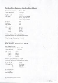
Document - NORTH HUSTLERS - NOTES ON NORTH OR NEW HUSTLERS
... on the North Hustlers or New Hustlers Mine on the Hustlers Line of Reef... Hustlers Mine on the Hustlers Line of Reef. One copy has Shaft ...BHS CollectionTwo handwritten pages and typed copies of same, of notes on the North Hustlers or New Hustlers Mine on the Hustlers Line of Reef. One copy has Shaft No 300. M. D. document, gold, north hustlers, north hustlers, north or new hustlers, shaft no 300 m. d. -
 Bendigo Historical Society Inc.
Map - STRUGNELL COLLECTION: UNITED HUSTLER'S & REDAN & K.K.MINES, September 1913
... Map, Hustler's Line of Reefs, Bendigo, United Hustler's...,Bendigo, Map, Hustler's Line of Reefs, Bendigo, United Hustler's ...Map, Hustler's Line of Reefs, Bendigo, United Hustler's & Redan, & K.K.Mines, Plate No.XXV11 (27), Long Gully, Lightning Hill Line of Reefs at surface.Dated September 1913 //Bulletin 33.Signed H.A.Whitelaw.Underground Survey Office,Bendigo,map, bendigo, united hustler's, redan, k.k.mines -
 Bendigo Historical Society Inc.
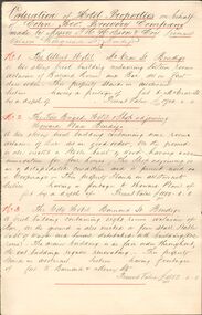
Financial record - COHN BROTHERS COLLECTION: HANDWRITTEN VALUATIONS OF HOTELS
... . British & American. 5. Hustlers Reef. 6. Garden Gully. 7.... Hustlers Reef. 6. Garden Gully. 7. Universal. 8. Brougham Arms. 9 ...394 c, Six handwritten pinned pages including abstract and Valuation of Hotel Properties on behalf Cohn Bros Brewery Company made by Messrs G M Hobson & Co licensed valuers Hargreaves St Bendigo dated 10/11/91 and signed G M Hobson. Nineteen hotels are valued. 1. Albert Hotel. 2. Fire Brigade Hotel. 3. City Hotel. 4. British & American. 5. Hustlers Reef. 6. Garden Gully. 7. Universal. 8. Brougham Arms. 9. Victoria. 10. United Kingdom. 11. West End. 12. View Bend. 13. Sparrowhawk. 14. Greyhound. 15. Normandy. 16 Noahs Ark. 17. Saw Mill. 18. Royal. 19. South Elmore. Total value £14305.00bendigo, industry, cohn bros brewery -
 Bendigo Historical Society Inc.
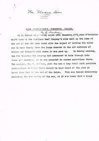
Document - TYPEWRITTEN ACCOUNT OF JOH MCCAVISTON'S WONDERFUL ESCAPE FROM THE HUSTLERS REEF MINE, 1873
... Wonderful Escape'' (from the Hustlers Reef mine, 1873). Detailed...'' (from the Hustlers Reef mine, 1873). Detailed story of shift ...Typewritten 10-page account of ''John McCaviston's Wonderful Escape'' (from the Hustlers Reef mine, 1873). Detailed story of shift boss, M'Caviston who descended into the flooding mine to warn workers below (who had actually left somewhat before) and who was himself trapped. The water in the shaft rose to a much higher level but M'Caviston was saved by being able to take refuge in a drive that had a 'stulling' (a mound of stones under a raised portion of the drive - allowing for an amount of trapped air). The account concludes as follows: ''The preservation of his life was discussed from a scientific point of view, and diverse opinions were expressed, and doubts (sic)'' (there is no page 11). No date on this document; handwritten on front page is ''The Flooded Mine'' ''By G Mackay'' (Occasional handwritten notations to text)document, names of bendigo pioneers, bendigo goldfields -
 Bendigo Historical Society Inc.
Map - STRUGNELL COLLECTION: HUSTLER'S LINE OF REEFS, BENDIGO, September 1913
... Map, Hustler's Line of Reefs, Great Extended Hustler's Mine..., Bendigo. Map, Hustler's Line of Reefs, Great Extended Hustler's ...Map, Hustler's Line of Reefs, Great Extended Hustler's Mine Plan,Plate No X (10).Bulletin No 33 Signed H.A.Whitelaw Underground survey Office Bendigo September 1913 Drawing has a table showing depths of levelsUnderground Survey Office, Bendigo.map, bendigo, great extended hustler's mine -
 Bendigo Historical Society Inc.
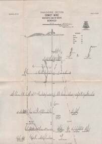
Map - STRUGNELL COLLECTION: HUSTLER'S LINE OF REEFS, BENDIGO, September 1913
... Map, Hustler's Line of Reefs, Comet Mine, Longitudinal..., Hustler's Line of Reefs, Comet Mine, Longitudinal Section.Plate ...Map, Hustler's Line of Reefs, Comet Mine, Longitudinal Section.Plate No.XXV1 (26).Bulletin No 33 Signed H.A.Whitelaw Underground survey Office Bendigo September 1913 Drawing shows the vertical shaft descending to over 1692 feetUnderground Survey Office, Bendigo.map, bendigo, comet mine -
 Bendigo Historical Society Inc.
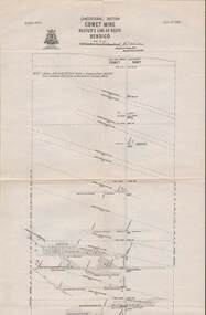
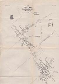
Map - COMET MINE - PLAN OF COMET MINE
... Plan of the Comet Mine on the Hustler's Line of Reefs...MINING Parish Map Hustler's Line of Reefs Comet Mine Plan ...Plan of the Comet Mine on the Hustler's Line of Reefs Bulletin No 33, Plate No XXIV signed by H S Whitelaw, Underground Survey Office Bendigo, September 1913. Upper and Lower Levels and approximate boundaries shown. Depths shown.Geological Survey of Victoriamining, parish map, hustler's line of reefs, comet mine plan bulletin no 33 plate no xxiv -
 Bendigo Historical Society Inc.
Document - VICTORIA HILL - SELF TOUR OF GOLDFIELDS NO 1
... Reserve (City Mine), Great Extended Hustlers, The Hustlers Reef... The Hustlers Reef Lansell's Comet The United Hustlers and Redan Garden ...Two copies (a & b) of a Royal Historical Society of Victoria, Bendigo Branch Self Tour of Goldfields No 1. The guide is to enable the tourist to locate and see for himself some of the gold mining area of Bendigo. Mines mentioned are: Deborah, North Deborah, Central Deborah, The Fortuna Hustlers, Hustlers Royal Reserve (City Mine), Great Extended Hustlers, The Hustlers Reef, Lansell's Comet, The United Hustlers and Redan, Garden Gully United, Central Nell Gwynne, The Old Chum, The New Chum and Victoria, The Lazarus, The New Chum United, The New Chum Consolidated, The Garibaldi, Advance, Lansell's 180, The Victoria Quartz, North Old Chum, The Ironbark, The Hercules, The Carlisle United, The Mungo Group, The Ellenborough, The St. Mungo, The Lady Barkly, South St. Mungo. Notes also include wages at the Fortuna Hustlers in 1906 and 1907, gold yield, depth of shaft, Dividends and Calls. Notes compiled by Mr. A. Richardson.document, gold, victoria hill, self tour of goldfields no 1, deborah (big deborah), north deborah, central deborah, the fortuna hustlers, hustlers royal reserve (city mine), great extended hustlers, the hustlers reef, lansell's comet, the united hustlers and redan, garden gully united, central nell gwynne, the old chum, the new chum and victoria, the lazarus, the new chum united, the new chum consolidated, the garibaldi, advance, lansell's 180, the victoria quartz, north old chum, the ironbark, the hercules, the carlisle united, the mungo group, the ellenborough, the st. mungo, the lady barkly, south st. mungo, hustlers hill, new chum hill, jonathan harris, j hustler, messrs latham and watson, buckell & jeffrey, camp hill school, mechanics institute eaglehawk, duke of edinborough, geo lansell, the k k shaft, williamsons, little's claim, rosalind park, mr pryor, gold mines hotel, burrowes and sterry, bonatti, menzies, hildebrant and koch's, ellesmere, p m g repeater station, mr lazarus, mt alvernia hospital, mr clarke magee, rae's, jeweller's shop, hopetoun band room, manchester arms hotel, wattle gully mine chewton, long gully post office, 'pope pius' roman catholic church, kentish, mr j b watson, california gully state school, duke of edinborough, new st mungo, duchess tribute, south devonshire, duchess of edinborough, west united devonshire, united devonshire, princess alexandra, hopewell, miners' phthisis, bendigo goldfields, mr a richardson -
 Bendigo Historical Society Inc.
Map - STRUGNELL COLLECTION: HUSTLER'S LINE OF REEFS, BENDIGO, September 1913
... Map, Hustler's Line of Reefs, Comet Mine, Transverse..., Hustler's Line of Reefs, Comet Mine, Transverse Section, Plate ...Map, Hustler's Line of Reefs, Comet Mine, Transverse Section, Plate No.XXV (25). Bulletin No 33 Signed H.A.Whitelaw. Drawing shows the vertical shaft descending to over 1692 feet and appears to show samples of connecting horizontal shafts with their respective mineral contentsUnderground Survey Office, Bendigo.map, bendigo, comet mine -
 Bendigo Historical Society Inc.
Map - STRUGNELL COLLECTION: HUSTLER'S LINE OF REEFS, BENDIGO, September 1913
... Map, Hustler's Line of Reefs, Comet Mine, Bendigo..., Hustler's Line of Reefs, Comet Mine, Bendigo Plan.Plate No.XX1V (24 ...Map, Hustler's Line of Reefs, Comet Mine, Bendigo Plan.Plate No.XX1V (24). Map, Bulletin No 33 Signed H.A.Whitelaw Underground survey Office Bendigo September 1913 Drawing shows upper and lower levels and appears to show samples of connecting horizontal shafts with their respective mineral contentsUnderground Survey Office, Bendigo.map, bendigo, comet mine -
 Bendigo Historical Society Inc.
Map - STRUGNELL COLLECTION: HUSTLER'S LINE OF REEFS, BENDIGO, September 1913
... Map, Hustler's Line of Reefs, Great Extended Hustler's Mine..., Bendigo. Map, Hustler's Line of Reefs, Great Extended Hustler's ...Map, Hustler's Line of Reefs, Great Extended Hustler's Mine, Longitudinal Section Plate No X111 (13). Bulletin No 33 Signed H.A.Whitelaw Underground survey Office Bendigo September 1913 Drawing shows mine shaft to over 3454 feet deep and appears to show samples of connecting horizontal shaftsUnderground Survey Office, Bendigo.map, bendigo, great extended hustler's mine -
 Bendigo Historical Society Inc.
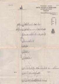
Map - UNITED HUSTLER'S & REDAN & K. K. MINES - PLAN OF UNITED HUSTLER'S & REDAN & K. K. MINES
... on the Hustler's Line of Reefs Bulletin No 33 Plate No XXVIII. Plan shows...MINING Parish Map United Hustler's & Redan & K. K. Mines ...Plan of the United Hustler's & Redan & K. K. Mines on the Hustler's Line of Reefs Bulletin No 33 Plate No XXVIII. Plan shows depth of levels, stone encountered and some geological features. Geological Survey of Victoria emblem and signed by H S Whitelaw, Underground Survey Office Bendigo, September 1913. mining, parish map, united hustler's & redan & k. k. mines, united hustler's and redan shaft, k. k. shaft, h s whitelaw -
 Bendigo Historical Society Inc.
Document - Hustlers, Sheepshead and Deborah lines of reef
... , . The mines along the Hustlers line of reef and the Sheepshead line... mining Deborah line of reef Sheepshead line of reef Hustlers line ...Albert Richardson was a mining historian who wrote widely on the mines of the Bendigo Goldfield. The park opposite the Goldmines Hotel in Marong Road, is named in his honour. Five page document, hand written by Albert Richardson on lined foolscap and edited with cross-outs and insertions, . The mines along the Hustlers line of reef and the Sheepshead line of reef are described. Mines listed on Hustlers line of reef: Fortuna Hustlers (1888 - 1913), shaft 2,240 feet at rear of Buckell and Jeffrey's offices; Royal Hustlers Reserve No. 2 - two shafts 'City" 860 feet, now covered by R.S.L. building Pall Mall, steel poppet legs 60 ft high and 'Park Shaft" at rear of Camp Hill School, 1,775 feet, steel poppet legs 60 feet high; Hustlers Hill Group first worked by Jonathan Harris in 1853 and bounded by Valentine, Anderson and Ironbark Creek to the north and Milroy Street to the east, one of first areas worked for quartz reefing. It with Garden Gully line west and Victoria Hill Ironbark, formed by far the richest cross section of the Bendigo Goldfield. Great Extended Hustlers (1865-1921) close to intersection of Anderson Street and Hustlers Road, mullock heap against road and shored up around shaft, steel poppet legs now at Wattle Gully mine, Chewton, large winding machine, air compressor south of shaft and 36 head crushing battery. Hustlers Reef (Old Hustlers) and Hustlers Reef No. 1, two shafts, main 2,210 feet, about 220 yards east of Moran Street and against Fenton Street. , No. 1 shaft 1,140 feet and about 155 yards east of Moran Street. Lansell's Comet, Lightining Hill line, 2.100 feet, on Comet Hill approx 70 yards west of Holmes Road, near Comet Creek, steel poppet legs. United Hustlers and Redan (1876-1918), main Redan, 1,830 feet about 155 yards west of Sandhurst Roead, in line with Comet Hill State School, this hill known as Redan Hill. North, or New Hustlers, once known as Agnew Hustlers, wooden poppet legs, south side, Kneebone Street, Eaglehawk. Derby line, Johnson's No. 3, South Johnson's (east shaft of Collman and Tacchi) 439 feet on west wide of Woods Street, south of Wetherall Street. Paddy's Gully Line, south to north, some shafts - Lansell's 'Sandhurst" ('Needle") Eaglehawk Road shaft 2,425 feet, about 50 yards east of Needle Loops, a brick square sided chimney with Cleopatra Needle top. British American, 789 feet, just south of Holdsworth Road. Collman and Tacchi, main shaft 2,588 feet, 60 yards west of Eaglehawk Road, California Gully. Deborah Line of Reef, The Deborah (1932-1954) shaft 2.017 feet, west of Adams Road and south of Abel Street, Quarry Hill. North Deborah (1937 - 1954) shaft 1,151 feet, Breen Street, Quarry Hill, steel poppet legs. Central Deborah (1939-1954) shaft 1,347 feet Sheepshead line of reef, Lansell's South Red, White and Blue, shaft 2,124 feet, north east of Bellevue Road and 220 yards east of Adams Road. The New Red, White and Blue Consolidated (Big Blue) main shaft 2,416 feet. Lansell's Bendigo Battery 105 head, north of 'Big Blue" on his freehold lease, commenced crushing on 24th February 1895. After closing was erected as the Showground's Industrial Hall, July 1926. North Red, White and Blue, burnt down February 1926, new company 1934, closed 1938. Document is part of the Albert Richardson Collection of Bendigo mining history. bendigo, gold mining, deborah line of reef, sheepshead line of reef, hustlers line of reef, royal hustlers reserve mine, hustlers hill group of mines, great extended hustlers, hustlers reef no. 1, lightning hill line, old comet, collman and tacchi, lansell's comet, north deborah, central deborah, dhrrpdhrsf linr og trrg, new red, white and blue consolidated mine, big blue, lansell's bendigo battery, north red, white and blue mine, albert richardson collection -
 Bendigo Historical Society Inc.
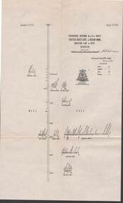
Map - STRUGNELL COLLECTION: UNITED HUSTLER'S & REDAN MINE, September 1913
... Hustler's & Redan Mine, Hustler's Line of Reef, Bendigo. Plate... & Redan Mine, Hustler's Line of Reef, Bendigo. Plate No. XXX (30 ...Map, Transverse Sections N. & S. Of shaft, United Hustler's & Redan Mine, Hustler's Line of Reef, Bendigo. Plate No. XXX (30).Bulletin No 33 Signed H.A.Whitelaw. Drawing shows the vertical shaft descending to over 976 feet and appears to show samples of connecting horizontal shafts with their respective mineral contentsUnderground Survey Office, Bendigo.map, bendigo, hustler's & redan mine -
 Bendigo Historical Society Inc.
Map - STRUGNELL COLLECTION: HUSTLER'S LINE OF REEFS K.K.MINE, September 1913
... Map, Hustler's Line of Reefs, K.K.Mine,Transverse..., Hustler's Line of Reefs, K.K.Mine,Transverse section.Plate No.XXX11 ...Map, Hustler's Line of Reefs, K.K.Mine,Transverse section.Plate No.XXX11(32).Geological Survey of Victoria.Bulletin 33.Signed H.A.Whitelaw. Drawing shows the vertical shaft descending to over 1932 feet and appears to show samples of connecting horizontal shafts with their respective mineral contents and dotted lines appear to show connecting reefs .Underground Survey Office, Bendigo,map, bendigo, k.k.mine -
 Bendigo Historical Society Inc.
Map - STRUGNELL COLLECTION: UNITED HUSTLER'S & REDAN & K.K.MINES, September,1913
... Map, United Hustler's & Redan & K.K.Mines, Hustler's Line... Bendigo united hustler's redan k.k.mines Underground Survey Office ...Map, United Hustler's & Redan & K.K.Mines, Hustler's Line of Reefs, Bendigo.Plat No.XXX1(31),. NOTE:- Plates 4,8,13,20,26,& 31 form a Longitudinal Section from Fortuna Hustler's to Hystler's Consols Mine. Bulletin 33.Signed H.A.Whitelaw. Drawing shows the vertical shafts descending to over 1932 feet and 1805 feet respectively .Underground Survey Office, Bendigo.map, bendigo, united hustler's, redan, k.k.mines -
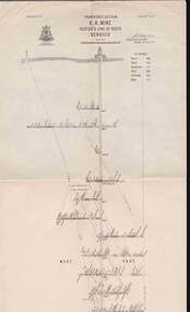
 Bendigo Historical Society Inc.
Map - STRUGNELL COLLECTION: HUSTLER'S LINE OF REEFS, BENDIGO, September 1913
... Map, Hustler's Line of Reefs, Great Extended Hustler's Mine..., Bendigo. Map, Hustler's Line of Reefs, Great Extended Hustler's ...Map, Hustler's Line of Reefs, Great Extended Hustler's Mine, Bendigo, Transverse Section. Plate No. X11 (12). Bulletin No 33 Signed H.A.Whitelaw Underground survey Office Bendigo September 1913 Drawing shows mine shaft to over 3454 feet deep and appears to show samples of connecting horizontal shafts with their respective mineral contentsUnderground Survey Office, Bendigo.map, bendigo, great extended hustler's mine -
 Bendigo Historical Society Inc.
Map - STRUGNELL COLLECTION: UNITED HUSTLER'S & REDAN MINE, September 1913
... , Hustler's Line of Reefs, Bendigo. Plate No. XX1X (29).Bulletin No 33... Bendigo hustler's & redan mine Underground Survey Office Map ...Map, United Hustler's & Redan Mine, Transverse Section, Hustler's Line of Reefs, Bendigo. Plate No. XX1X (29).Bulletin No 33 Signed H.A.Whitelaw. Drawing shows the vertical shaft descending to over 1805 feet and appears to show samples of connecting horizontal shafts with their respective mineral contents. One level shows respective water levels .Underground Survey Officemap, bendigo, hustler's & redan mine -
 Bendigo Historical Society Inc.
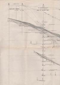
Map - COMET MINE - TRANSVERSE SECTION COMET MINE
... Transverse section of the Comet Mine on the Hustler's Line...MINING Hustler's Line of Reefs Transverse Section of Comet ...Transverse section of the Comet Mine on the Hustler's Line of Reef Bulletin No 33, Plate No XXV signed by H. A. Whitdon, Underground Survey Office Bendigo September,1913. Map shows depth of the different levels, the type of stone and shaft about 2020 deep. A number of smaller drawings on the side. Reference explaining the different types of stone, etc. Geological Survey of Victoriamining, hustler's line of reefs, transverse section of comet mine bulletin no 33 plate no xxv, lightning hill line of reef -
 Bendigo Historical Society Inc.
Document - MINING REPORTS - MAP OF PART OF THE BENDIGO GOLDFIELD INCLUDING WHITE HILLS AND EAGLEHAWK
... United, Great Ext'd Hustlers, Johnson's Reef, South New Moon, New... Hustlers Johnson's Reef South New Moon New Moon Catherine Reef ...BHS CollectionMap of part of the Bendigo Goldfield including White Hills and Eaglehawk. Map shows reef lines, gullies, railway line, tram route, type of rock, name of mine, Calls and Dividends. Also Deepest Mine Victoria Quartz 4614 ft. Names of Mines are Garden Gully United, Great Ext'd Hustlers, Johnson's Reef, South New Moon, New Moon, Catherine Reef, Virginia, Central Red White & Blue, Ironbark, Kock's Pioneer, Carlisle and the Hercules & Energetic. Map is part of the Albert Richardson Collection of mining documents and research. document, gold, mining reports, mining reports, map of part of the bendigo goldfield including white hills and eaglehawk, pabst bendigo goldfield, garden gully united, great ext'd hustlers, johnson's reef, south new moon, new moon, catherine reef, virginia, central red white & blue, ironbark, kock's pioneer, carlisle, hercules & energetic. victoria quartz -
 Bendigo Historical Society Inc.
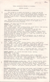
Document - MINING REPORTS - MINING RECORD FEB., 1862
... ), Hustler's Reef Quartz Mining & Drainage Company, Sailors' Gully... Company (Formerly Cooper's Little Redan), Hustler's Reef Quartz ...Photocopy of pages 2, 3, 4, 6 to 10 of The Mining Record, Feb., 1862. Items mentioned are:- Epsom and Huntly Leads, Pottery Flat, & c, Parliamentary Intelligence, Deep Sinking On Quartz Reefs, The Comet Company (Formerly Cooper's Little Redan), Hustler's Reef Quartz Mining & Drainage Company, Sailors' Gully Quartz Mining Company, Star Reef, Sailor's Gully, Bendigo, Star Reef Quartz Mining Company's Claim, Wilson & Co's Claim, Murdoch and Co's Claim, Hollick and Co.'s Claim, Cook and Co.'s Claim, Coote and Co.'s Claim, Sailor's gully quartz Mining Company's Claim, Garden Gully Reef, Knobel & Co.'s Claim, Ladams and Co.'s Claim, Southern Cross Company, The Rainbow Company, Barry and Co.'s Claim, Union Company's Claim, Winterbottom and Co.s Claim, Jury and Co.'s Claim, Piles and Co.'s Claim, Steers and Co.'s Claim, Watson and Co.'s Claim, Coles and Co.'s Claim, James and Co.'s Claim, Morgan, Kirchner and Co.'s Claim, Boyd and Co.'s Claim, Shanks and Co.'s Claim, Day and Co.'s Claim, Brown and Co.'s Claim, St. Mungo Quartz Mining Company and the Nelson Reef Quartz Mining Company.document, gold, mining reports, mining reports, mining record feb 1862, bell's life, wellington hotel, botanical gardens, mitchell gardens, bird-in-hand, independent co, ballarat co, perserverance co, north star co, all england co, macleod co, mather and co, gold washing co, bendigo valley co, robey and co, hobbs and co, taylor's, lewis and co, henwood and co, bullock and co, davey and co, webb and lathlean, the welshman's, bon accord, john thomas's, caledonian co, webster, hrdy bros, mcewen and co, the big engine co, epsom huntly and ironstone hill co, 'the thames' steamer, whitely and co, cambridge co, victoria co, dower m'intosh and co, thomas and davies, aurora co, brett's, thomas bros, mitchell brothers, ballarat co, north star co, all england co, mr b g davies, mr ramsay, dr evans, tarrangower times, mr humffray, clunes co, mr courtin, mr lawrence, port phillip and colonial gold mining co, mr bland, r brough smith, john s mcnair, john mathieson, mr r o smith, joseph millen, thomas kaye, john basset, william cook, james cousley, john hill, robert hollinger, thomas houston, george loudon, william manning, john matthews, john mcewen, thomas milligan, john moorhead, robert moorhead, david murdoch, andrew murdoch, joseph nevin, edward o'malley, wm newton paul, james reid, samuel robinson, jesse selwood, james shand, william woods, catherine united claimholders, star reef co, sailor's gully co, churchill davidson, wm wilson, john jervis, james patterson, john carmont, george m'naughten, alexander wiseman, james houston, m'lennan, clark, thomas hollick, james alfred bowles, john lampert, francis palmetser, nichols, little pumping engine co, m'niely, morrison, waight, john coote, robert hamilton, william wilson, john jervis, southern cross co, ladam's claim, knobel, bird, philip ladams, james anderson, cordon, ashley, godwin, burkamp, john lomasney, james bryant, matthew langridge, benjamin exley, j r finlayson, wormold, mccartney, schrade, schumacher, george barry, james patten, peter speares, thomas caley, shadbolt, john lomasney, peat, kenely, mcgenely, egan, exwell, james winterbottom, john winterbottom, william jury, jonathan laidman, john pile, simon howard, peter morris, bignall, charles robison, ferguson, thomas steers, adolphe witts, albert berchdolt, richard urand, thomas watson, klemm, boyd, abbot, peterson, taylor, henry day, walter wallan, brown, grennan, day, young, mr beckwith, joseph thomson, nelson reef quartz mining co -
 Bendigo Historical Society Inc.
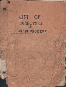
Document - MCCOLL, RANKIN AND STANISTREET COLLECTION: LIST OF DIRECTORS AND SHAREHOLDERS, 1950/61
... , New Monument, North Hustlers, Napoleon Reef, Deborah Extended..., North Hustlers, Napoleon Reef, Deborah Extended, Deborah United ...Documents: paper bag contains - well-worn booklet 21x16cm 'List of Directors & sharebrokers' for goldmines, meeting times, reports to press, company report recipients for Monument Hill Consolidated, Central Nell Gwynne, East Clarence, New Don, South Nell Gwynne, Deborah Gold Mine, South Deborah, North Virginia, Central Deborah, North Deborah Mining, Nell Gwynne Reef, Central Napoleon, New Monument, North Hustlers, Napoleon Reef, Deborah Extended, Deborah United, South Wattle Gully Company, Red, White & Blue Extended, Golden Carshalton, poor condition, also several company change of address notices.MCCOLL RANKIN AND STANSISTREETorganization, business, gold mining - legal, mccoll rankin and stansistreet -
 Bendigo Historical Society Inc.
Map - HUSTLER'S ROYAL RESERVE NO 2 MINE - PLAN OF THE HUSTLER'S ROYAL RESERVE NO 2 MINE
... on the Hustler's Line of Reefs Bulletin No 33, Plate No VI. Boundary... Hustler's Line of Reefs Geological Survey of Victoria H Herman W ...Plan of the Hustler's Royal Reserve No 2 Mine on the Hustler's Line of Reefs Bulletin No 33, Plate No VI. Boundary of Leases No 8898 and 8897 shown. Various levels shown and some geographical features. Geological Survey of Victoria emblem. H . Harman, Director, W. Dickson, Secretary for Mines and The Hon. J. Drysdale Brown, Minister of Mines and signed by H Whitdon, Underground Survey Office, Bendigo, September 1913. mining, parish map, hustler's royal reserve no 2 mine, hustler's line of reefs, geological survey of victoria, h herman, w dickson, the hon j drysdale brown mlc -
 Bendigo Historical Society Inc.
Map - K. K. MINE - TRANSVERSE SECTION K. K. MINE
... Transverse Section of the K. K. Mine on the Hustler's Line.... Mine Hustler's Line of Reefs Geological Survey of Victoria H S ...Transverse Section of the K. K. Mine on the Hustler's Line of Reefs, Bulletin No 33, Plate No XXXII. Map shows the different levels and their depth. Also, the different types of stone encountered and geological features such as spurs and faults. Has drawing of the poppet legs at the top of the shaft and sill of shaft 773.56 ft above sea level. Map has Geological Survey of Victoria crest and signed by H S Whitelaw, Underground Survey Office Bendigo, September 1913. miners, fortuna hustler's mine, transverse section of k. k. mine, hustler's line of reefs, geological survey of victoria, h s whitelaw