Showing 11703 items matching " islands"
-
 Victorian Aboriginal Corporation for Languages
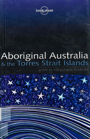
Book, Sarina Singh, Aboriginal Australia & the Torres Strait Islands : guide to Indigenous Australia, 2001
... Aboriginal Australia & the Torres Strait Islands : guide ...Comprehensive text with maps, coloured photos etc., dealing with all of Indigenous Australia. Provides historical references. Details of the Mabo finding.maps, b&w photographs, colour photographs, illustrations, word listsculture, travel guide, tourism, art, food -
 Peterborough History Group
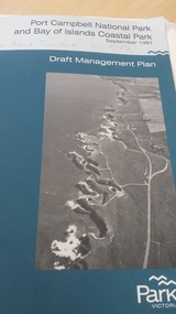
Book, Port Campbell National Park and Bay of Islands Coastal Park Draft Management Plan September 1997, 1997
... Port Campbell National Park and Bay of Islands Coastal Park ...Information re planning for Park released for public comment in 1997.Contributes information on the history and development of the Bay of Islands Coastal ParkGovernment published 81 page + maps book.peterborough 3270, bay of islands coastal park, parks victoria - peterborough, bay of islands -
 Peterborough History Group
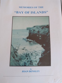
Book, Memories of the Bay of Islands + Crofts Bay Huts
... Memories of the Bay of Islands + Crofts Bay Huts ...Early use of Crown Land for holiday makers prior to the Great Ocean Road extension, when leaseholders were forced to relinquish their land and houses. Includes a list of the names of occupants at that time. Also includes letters from the Crown Lands Dept about the efforts to retain the Crofts Bay Huts.Significant because it is an eyewitness description of the huts which were demolished in the mid 1970's. Also describes holiday activities and mentions other families in the area.Folder containing the photocopy of the book by Joan Densley and the separate story of the Crofts Bay huts.including copies of Crown Land documents and letters. Includes copy of photographs of the huts and beach.peterborough, crofts bay, bay of islands, joan densley, great ocean road, crofts bay huts, bay of islands huts -
 Rutherglen Historical Society
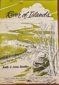
Book, Kath Bentley et al, River of Islands: Charts of the River Murray Yarrawonga Weir to Hume Dam, November 1983
... River of Islands: Charts of the River Murray Yarrawonga ...Book contains information and sketch maps to aid in the navigation of the Murray River, with advice on hazards to look for as these will change over time.74 page A4 book with a drawing of a boat on the Murray River on the coverAutographed on the title page by the authors: "9-1-84 Leon Bentley | Kath Bentley"murray river, boating, river navigation, boating safety -
 Tramways/East Melbourne RSL Sub Branch - RSL Victoria Listing id: 27511
Book, Jersey Museum, THE FIRST CASUALTY (The German Underground Hospital) and Jersey's Occupation Experience. German occupation of Jersey Islands)
... Jersey's Occupation Experience. German occupation of Jersey Islands) ... -
Moorabbin Air Museum
Book - AUSTRALIA, NEW ZEALAND AND THE SW PACIFIC ISLANDS, AIR-BRITAIN (HISTORIANS) LTD DEPARTMENT M, 1977
... AUSTRALIA, NEW ZEALAND AND THE SW PACIFIC ISLANDS ... -
Moorabbin Air Museum
Document (Item), Transcript Of Evidence Presented To The Committees Inquiry Into Freight And Passenger Transport To Australia's External Territories Of Christmas, Cocos (Keeling),Norfolk Islands Public Hearing In Canberra
... Territories Of Christmas, Cocos (Keeling),Norfolk Islands Public ... -
Moorabbin Air Museum
Booklet (Item) - Submissions to the Committee's Inquiry into Freight and Passenger Transport to Australia's External Territories of Christmas, Cocos (Keeling), Norfolk Islands
... , Cocos (Keeling), Norfolk Islands ... -
Moorabbin Air Museum
Booklet - THE HISTORIC CIVIL AIRCRAFT REGISTERS OF PAPUA NEW GUINEA AND THE PACIFIC ISLANDS, TONY ARBON et al, NO DATE
... AND THE PACIFIC ISLANDS ... -
Moorabbin Air Museum
Map (Item) - Department of the Navy Hydrographic Office Air Navigation Chart No V30-57 South Pacific Ocean Australia and North East Seas and Islands
... Seas and Islands ... -
 Stawell Historical Society Inc
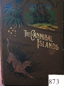
Book, R. M. Ballantyne, The Cannibal Islands
... The Cannibal Islands ...stawell -
 Round the Bend Conservation Co-operative
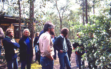
Joining with the Bend of Islands Conservation Association (BICA) members shared knowledge and learned about local flora and fauna
... Joining with the Bend of Islands Conservation Association ... -
Thompson's Foundry Band Inc. (Castlemaine)
Sheet Music, Misty Islands
... Misty Islands ... -
 Wodonga & District Historical Society Inc
Book - River of Islands, Kath & Leon Bentley, 1985
... River of Islands ...A detailed guide to the Murray RIver, including descriptions of the terrain and settlements along the river as well as detailed charts of the river from Yarrawonga to the Hume WeirAn A4 sized publication including text, photos and maps describing the history and surrounds of the Murray River from Yarrawonga to the Hume Weir.A detailed guide to the Murray RIver, including descriptions of the terrain and settlements along the river as well as detailed charts of the river from Yarrawonga to the Hume Weirmurray river navigation, murray river settlement, leisure activities - boating -
 Mrs Aeneas Gunn Memorial Library
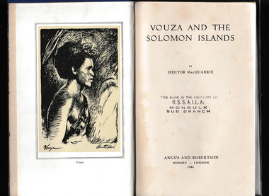
Book, Angus and Robertson, Vouza and the Solomon islands, 1946
... Vouza and the Solomon islands ...A description of the Solomon islands and its inhabitantsIll, maps, p.217.A description of the Solomon islands and its inhabitantssolomon islands - description and travel, solomon islands - social life and customs -
 Bacchus Marsh & District Historical Society
Ephemera - Ticket, Illustrated Lecture by Hon W. L. Allardyce on the Falkland Islands
... Islands ...Public lectures were a common activity in Bacchus Marsh in the early 1900s. These were usually held in the Mechanics Institute Hall in Main Street, or in the Australian Natives Association (ANA) Hall also in Main Street Bacchus Marsh. This ticket is a typical example of the elaborate design used for invitations at this time. This lecture was promoted as an 'illustrated lecture'. In this instance it was according to contemporary newspaper reporting a lecture which included a series of 'lantern views'. These were pictures—paintings, prints, or photographs—on transparent plates (usually made of glass), and were then projected for viewing through an image projector commonly called a 'magic lantern'. Printed ticket on card. Rectangular shape.public lectures, bacchus marsh mechanics institute, mechanics institutes, ephemera bacchus marsh -
 Dandenong/Cranbourne RSL Sub Branch
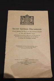
Book, His Majesty's Stationary Office for the Royal Norwegian Government Office, Secret German Documents seized during the raid on the Lofoten Islands on the 4th March, 1941, 1941
... Lofoten Islands on the 4th March, 1941. ...WWII Historical significance.Book containing German orders for the treatment of Norwegian Civilians during WWII.Embodying instructions to the Army on the control of the press and on collaboration with the Gestapo in dealing with Norwegian nationals. -
 Monbulk RSL Sub Branch
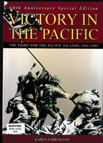
Book, Karen Farrington, Victory in the Pacific : the fight for the Pacific Islands 1942-1945, 2005
... Victory in the Pacific : the fight for the Pacific Islands ...On 7 December 1941, the Japanese navy attacked Pearl Harbour. Simultaneously, the Japanese army launched all-out assaults on Malaya, Hong Kong and the Philippines. The Japanese sphere of influence spread at a phenomenal rate. As nations of Asia collapsed one by one, and the British and US troops in the region were overwhelmed in short order, it seemed the Japanese dream of empire was about to be realized. Victory in the Pacific tells how the tide of Japanese victory was turned, and how the Allies fought their way the length and breadth of Burma and from island to island on their way to achieving final victory in the East.Ill, maps, index, p.144.non-fictionOn 7 December 1941, the Japanese navy attacked Pearl Harbour. Simultaneously, the Japanese army launched all-out assaults on Malaya, Hong Kong and the Philippines. The Japanese sphere of influence spread at a phenomenal rate. As nations of Asia collapsed one by one, and the British and US troops in the region were overwhelmed in short order, it seemed the Japanese dream of empire was about to be realized. Victory in the Pacific tells how the tide of Japanese victory was turned, and how the Allies fought their way the length and breadth of Burma and from island to island on their way to achieving final victory in the East. world war 1939-1945 - campaigns - pacific area, world war two 1939-1945 - pacific theatre -
 Phillip Island and District Historical Society Inc.
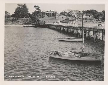
Photograph, 1940's - 1950's
One of a collection of 9 photographs donated by the former Shire of Phillip Island. One of a seried of photographs sold as a pack of 7 postcards for tourists/visitors to Phillip Island.Black & White photograph of Cowes Pier showing Island of Wight Hotel and Cowes Jetty Shed in the background. Two boats in foreground."View from the Pier Cowes, Phillip Island"cowes pier phillip island, cowes jetty, isle of wight hotel phillip island, cowes jetty shed, shire of phillip island -
 Phillip Island and District Historical Society Inc.
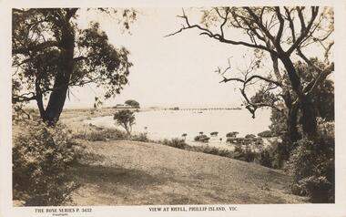
Sepia Photograph, 1920
This album was presented to the Earl of Stradbroke by Fathers of Soldiers on Phillip Island. The photo is of Rhyll shore line with pier in back ground.Sepia photograph of the shore at Rhyll, Phillip Island with pier in background.Rose Series P 3432 View at Rhyll, Phillip Island, Vicphillip island, rhyll shoreline, rhyll pier -
 Lakes Entrance Historical Society
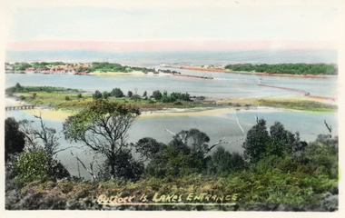
Postcard - Bullock Island, Bulmer H D, 1920c
... Islands ...Hand coloured postcard of Bullock Island and the man made entrance from Bass Strait to the Gippsland Lakes. Also shown the small township, unofficially known as Carpentertown at the entrance works. Photo taken from Kalimna Hill, shrubbery in foreground. Lakes Entrance VictoriaBullock Island, Lakes Entrancewaterways, bridges, islands, jetties -
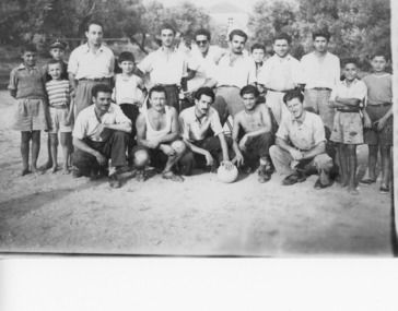 Ithacan Historical Society
Photograph, Soccer team, 2 July 1951
... Village of Platrithia, Ithaca, Ionian Islands, Greece ...The photograph is of members of a local soccer team on the Greek island of Ithaca in 1951. Stathi Raftopoulos is pictured on the left to the right of the young children. Soccer is a very popular game both in Greece and amongst the Greek community in Australia.A scanned black and white photograph of men and boys posing for a soccer team photograph. Thirteen people are standing and five are kneeling in the front with the soccer ball. -
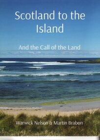 Phillip Island and District Historical Society Inc.
Book, Warwick Nelson & Martin Brabon, Scotland to the Island. And the call of the land, 2022
The Miller family were one of the early settlers on Phillip Island. Robert Miller selected land in Ventnor in 1868. His daughter, Catherine, later lived nearby with the neighbouring bay named after her, Kitty Miller Bay.HistoricalBook - Scotland to the Island and the call of the land. Large BookScotland to the Island. and the call of the land. Warwick Nelson & Martin Brabonmiller family, kitty miller bay phillip island, catherine walker (nee kitty miller), warwick nelson, robert miller, farming, ventnor -
 Phillip Island and District Historical Society Inc.
Photographs, 1926
Part of a collection of photographs cut from old photo album with multiple photos per page. Margaret Webster donated the photographs. Margaret's parents were Sir Charles & Lady McGrath who lived near the RSL on Ventnor Road, Phillip Island.286-01 - Sepia photograph of the beach at Cape Woolamai, Phillip Island. 286-02 - Sepia photograph of The Sentinel, Cape Woolamai, Phillip Island. 286-03 - Sepia photograph of The Terrace, Cape Woolamai, Phillip Island. 286-04 - Sepia photograph of Pyramid Rock, Phillip Island. 286-05 - Sepia photograph of the cliffs at Cape Woolamai, Phillip Island.286-01 - "Beach Cape Woolamai Phillip Island" 286-02 - "The Sentinel Cape Woolamai Phillip Island" 286-03 - "The Terrace Cape Woolamai" 286-04 - "Pyramid Rock P.I." 286-05 - "Cliffs - Cape Woolamai"coastline cape woolamai, pyramid rock, the sentinel cape woolamai, the terrace cape woolamai, margaret webster -
Phillip Island and District Historical Society Inc.
Photograph, 1929-1938
Phillip Island Punt - 1929/1938. Part of an album compiled and donated by Mrs. Helen JanssonBlack & White Print (probably from a publication) of the 2-car Phillip Island PuntDescriptive caption adjoining photo print 1929 "Phillip Island Punt"local history, photography, photographs, slides, film, civil engineering, bridges, phillip island bridge, black & white photograph, mrs helen jansson, early connection to mainland, bridges -
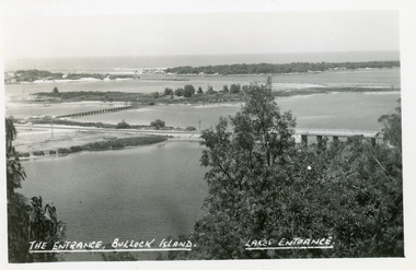 Lakes Entrance Historical Society
Postcard - Bullock Island, The Lakes Studio, 1920c
... Islands ...One black and white copy 17 x 25Black and white postcard showing North Arm Bridge, Bullock Island and foot bridge northern end of piers at entrance to Bass Strait and sand dunes. Left foreground shows power pole and water bore and telephone poles along Princes Highway Lakes Entrance Victoria.The Entrance, Bullock Island, Lakes Entranceislands, bridges, waterways, topography -
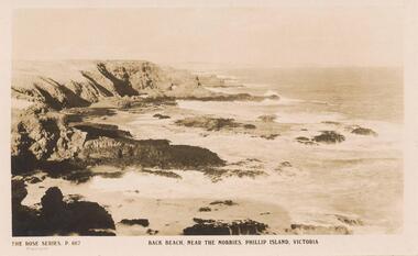 Phillip Island and District Historical Society Inc.
Sepia Photograph, 1920
This ablum was presented to the Earl of Stradbroke by the Fathers of Soldiers and Returned Soldiers 16/2/1923. The photo is of the Back Beach near The Nobbies, Phillip Island.Postcard showing the Back Beach near The Nobbies, Phillip Island, VictoriaRose Series P667 Back Beach, near The Nobbies, Phillip Island, Victoriaphillip island, back beach, earl of stradbroke, the nobbies -
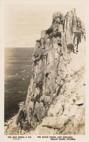 Phillip Island and District Historical Society Inc.
Sepia Photograph, 1920's
This album was presented to the Earl of Stradbroke by Fathers of Soldiers and Returned Soldiers 16/02/1923. Photo showing cliffs called The Watch Tower, Cape Woolamai, Phillip Island.Cliff known as "The Watch Tower", Cape Woolamai, Phillip Island, VictoriaRose Series P679. The Watch Tower, Cape Woolamai, Phillip Island, Victoriaphillip island, cape woolamai, earl of stradbroke, the watch tower cliffs -
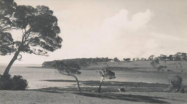 Phillip Island and District Historical Society Inc.
Photograph, Bryant West
... islands ...One of a collection of over 400 photographs in an album commenced in 1960 and presented to the Phillip Island & Westernport Historical Society by the Shire of Phillip IslandPhotograph of view of Churchill Island.local history, photography, photographs, churchill island, coastline, islands, phillip island, john jenner, bryant west -
 Lakes Entrance Historical Society
Photograph, LERHS, The Entrance viewed from Jemmys Point, 1997 c
... Islands ...The Entrance taken from Jemmys Point Lookout area showing sand dumped on Snake Island joining Rigby Island also sand dumped in middle of main channel Lakes Entrance Victoria. Also similar photographs for Heritage Study 7971 numbers 04207.1 in Spares and 04207.2 size 10 x 15 cm|One colour photograph of Entrance from boat looking directly down main channel in SparesColour photograph of the Entrance taken from Jemmys Point Lookout area showing sand dumped on Snake Island joining Rigby Island also sand dumped in middle of main channel Lakes Entrance Victoriaislands, waterways, gippsland lakes