Showing 1854 items matching " subdivision"
-
 Greensborough Historical Society
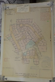
Planning Document, Subdivision Plan # 1016. Corner Weidlich and St Clems Roads Greensborough, 05/10/1981
Plan of Subdivision of land at corner of Weidlich Road and St Clems Road Greensborough.Plan (2 sheets) mounted on heavy card.Stamped and handwritten Council permissions, dates and other details.subdivision plans, weidlich road -
 Greensborough Historical Society
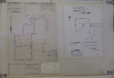
Planning Document, Subdivision Plan #1041. Elder Street Greensborough, 20/04/1983
Plan of Consolidation of Allotments 3 and 4 Brixton Avenue and Plan of Subdivision for Elder Street. An example of hard copy subdivision plans from the Greensborough area. Mainly from the Shire of Diamond Valley era (1964-1994).Plan (2 sheets) mounted on heavy card.Stamped and handwritten Council permissions, dates and other details.subdivision plans, elder street, brixton avenue -
 Greensborough Historical Society
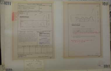
Planning document, Subdivision Plan #1011. Corner Mountainview Road and Hume Streets, 1981_
Plan of Strata Subdivision for units at corner of Mountainview Road and Hume Street Briar Hill.An example of hard copy subdivision plans from the Greensborough area. Mainly from the Shire of Diamond Valley era (1964-1994).Plan (2 sheets) mounted on heavy card.Stamped and handwritten Council permissions, dates and other details.subdivision plans, mountainview road, hume street -
 Ringwood and District Historical Society
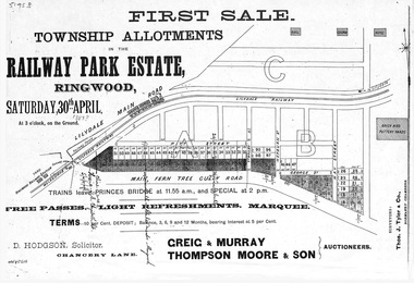
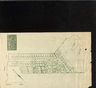
Flyer, Subdivision advertisement - Railway Park Estate, Ringwood, Victoria - circa 1887
Photocopy of advertisement for auction sale of township allotments in Railway Park Estate, Ringwood, on Saturday 30th April (1887?), with terms of sale and location map.Subdivision map includes Pitt Street and Main Ferntree Gully Road (later Bedford Road). (Agents) Greig & Murray, Thompson Moore & Son, Auctioneers. -
 Greensborough Historical Society
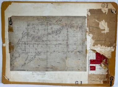
Poster - Planning Document, Shire of Diamond Valley, Subdivision Plan # G 1, Watsonia, 1962 and 1976
Plan of Subdivisions in Shire of Diamond Valley: Side 1: subdivision of LP5406 bounded by Plenty Road, Greensborough Road, Meakin Avenue, Watsonia and includes Aqueduct Road, 1976. Side 2: 2 plans - Keelbundoora: Morwell Avenue and Grace Street; Nillumbik: Inglis Street and Chute Street Diamond Creek, 1962An example of hard copy subdivision plans from the Greensborough area. Mainly from the Shire of Diamond Valley era (1964-1994).Plan (2 sided) mounted on heavy card. Contains 2 sheets pasted together.Stamped and handwritten Council permissions, dates and other details. subdivision plans, diamond creek, shire of diamond valley -
 Greensborough Historical Society
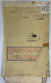
Poster - Planning Document, City of Heidelberg, Subdivision Plan # G 29 Part 2, Crown portion 16, Greensborough, 1951
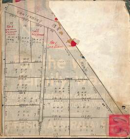
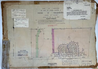
Plan of Subdivisions in City of Heidelberg: Parish of Keelbundoora: Crown portion 16 - Daours Court and Devonshire Road, 1951.An example of hard copy subdivision plans from the Greensborough area. Mainly from the Shire of Diamond Valley era (1964-1994).Plan (single sided) mounted on heavy card. Stamped and handwritten Council permissions, dates and other details.subdivision plans, city of heidelberg -
 Ringwood and District Historical Society
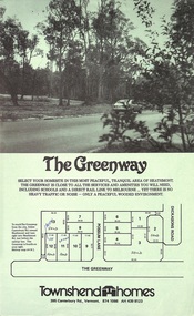
Document - Folder, Greenway Estate Subdivision, Heathmont, Victoria - 1981
Manilla folder containing single page advertisement for sale of 13 residential allotments, photocopied plan section of surveyor's certificate, letter from vendor to agent dated 24th February, 1981, and typewritten price list. Subdivision includes Possum Lane and The Greenway, Heathmont. Vendor - Townshend Homes (Vic) Pty Ltd., 395 Canterbury Road, Vermont, 3133, Phone 874-1066. P.O. Box 64, Vermont, 3133. Agent - C.E. Carter & Son, 122 Whitehorse Road, Ringwood, Vic., 3134. -
 Whitehorse Historical Society Inc.
Map, Subdivision of Allotment 122a, 1972
Subdivision of land along Livermore Close and Moore Road, Vermont South.Subdivision of land along Livermore Close and Moore Road, Vermont South. Original survey Rob Poole 1899. Stamp indicates 'Land on this plan is in proclaimed survey No 21. Survey Coordination Act 1940. As from 9 Aug 1972. Two maps in different scales.Subdivision of land along Livermore Close and Moore Road, Vermont South. land subdivision, livermore close, vermont south, moore road, vermont south, dandenong creek -
 Greensborough Historical Society
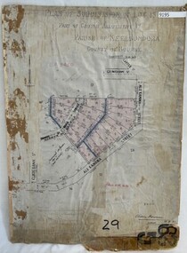
Poster - Planning Document, City of Heidelberg, Subdivision Plan # G 29 Part 1, Crown allotment 17, Greensborough, 1922
Plan of Subdivisions in City of Heidelberg: Parish of Keelbundoora: Crown allotment 17 - Warwick Road, Clydbank Street, Alexandra Street, 1922.An example of hard copy subdivision plans from the Greensborough area. Mainly from the Shire of Diamond Valley era (1964-1994).Plan (single sided) mounted on heavy card. Stamped and handwritten Council permissions, dates and other details.subdivision plans, city of heidelberg -
 Whitehorse Historical Society Inc.
Document, Vermont Subdivision, 19/04/2023
A Vermont Subdivision by Drake & Co.non-fictionA Vermont Subdivision by Drake & Co.drake & co, abbey walk, the mews, little john's court, long staff court, holyrood drive, penllyne ave -
Whitehorse Historical Society Inc.
Article - Newspaper cutting, Subdivision furore, 1994
Vermont South Traders and residents are opposing Shell Australia's plans to subdivide a prominent Nunawading Council owned site on Burwood Highway for a 24 hour petrol station, McDonalds and Video library and cafe.Vermont South Traders and residents are opposing Shell Australia's plans to subdivide a prominent Nunawading Council owned site on Burwood Highway for a 24 hour petrol station, McDonalds and Video library and cafe. Objectors say it is a conflict of interest for the council as the sale of the land is conditional on council approving the subdivision.Vermont South Traders and residents are opposing Shell Australia's plans to subdivide a prominent Nunawading Council owned site on Burwood Highway for a 24 hour petrol station, McDonalds and Video library and cafe.shops, shell australia, city of nunawading, vermont south shopping centre, burwood highway, vermont south, nos 473-493 -
 Greensborough Historical Society
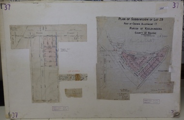
Planning Document, Subdivision Plan # 37. Poulter Avenue and Bicton Street; and, Adeline Street and Grimshaw Street Greensborough, 1971_
Plan of subdivision Lot 29, Part of Crown Allotment, Parish of Keelbundoora, County of Bourke. Poulter Avenue and Bicton Street; and, Adeline Street and Grimshaw Street.An example of hard copy subdivision plans from the Greensborough area. Mainly from the Shire of Diamond Valley era (1964-1994).Plan (2 sheets) mounted on heavy card. subdivision plans, grimshaw street, poulter avenue, adeline street -
 Ringwood and District Historical Society
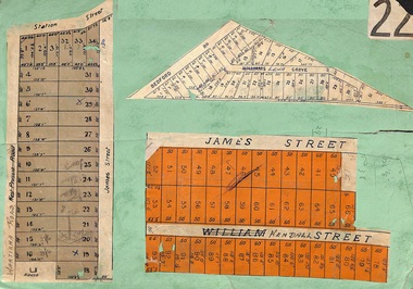
Card, Subdivision Maps - Ringwood, Victoria - (Undated, circa 1920s)
Collage of three residential allotment maps on green cardboard backing.Subdivisions include West Prussia Road, Wantirna Road, Station Street, James Street, Bedford Road, Williams Grove (later Lena Grove), and William Street (later Kendall Street), Ringwood. -
 Ringwood and District Historical Society
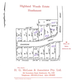
Document, Subdivision Plan - Highland Woods Estate, Heathmont, Victoria (undated, circa 1968)
Map of 15 residential allotments for sale, with seven rubber-stamped SOLD and one with handwritten notation "$5650 1968". Subdivision includes Barrow Drive and Barnic Road, Heathmont. Agent - H.G. McLean & Associates Pty. Ltd., 166 Canterbury Road, Heathmont Vic., 3135, Telephones : 870-3422 A/hrs 870-5879. -
 Ringwood and District Historical Society
Map, Subdivision Plan of residential allotments on Canterbury Road, Bayswater (later surrounding Miller Road, Heathmont), Victoria - (Undated - circa 1930s)
Hand-drawn map on cardboard backing. Includes red pen notations marking allotments sold to Mrs A. Harrison, Mrs C Cornwall, J.M. Miller, and A.W. Dickson.Red pen notations mark allotments sold to Mrs A. Harrison, Mrs C Cornwall, J.M. Miller, and A.W. Dickson. Later subdivision of the map area took in Miller Road and Atunga Court developments. -
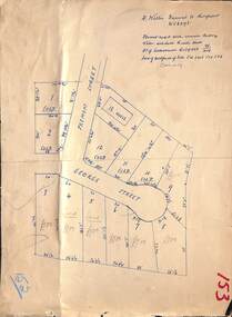
 Ringwood and District Historical Society
Map, Proposed Subdivision - Hilltop Estate, Heathmont, Victoria - circa 1925
Plan of Part of Crown Allotments 16 & 18, Parish of Ringwood, County of Mornington. Subdivision includes Site for Heathmont Station, Heathmont Road, George Street, Lilian Street, Edith Street, Edna Street, Great Ryrie Street. Inset locality plan also shows nearby Electric Railway Estate and Heathmont Station Estate. L.H. Webber, Licensed Surveyor, 440 Little Collins Street, Melbourne. -
 Ringwood and District Historical Society
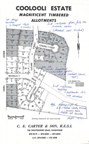
Document - Folder, Coolooli Estate Subdivision, Ringwood East, Vic. - Four Releases 1969-1975
Collection of Subdivision Plans, Land Sale flyers, Auction notices, and Real Estate Agent's notes for Coolooli Estate, Ringwood East, Victoria. Subdivision includes Coolooli Court, Isabel Avenue, Walhalla Drive, Cleland Street, Landell Court, Byways Drive, Heathwood Street and Hume Street, released over four stages - First Stage auction 16 August 1969, Second Release private sales from July 1970, Third Release Auction 11 September 1971, Final Release auction June 21st 1975. Agents - C.E. Carter & Son, 126 Whitehorse Road, Ringwood until moving to 122 Whitehorse Road in 1973 - Tel. 870 6024, 870 6830, 870 2519, A.H. 723 3298, 870 6960. Digitised copy of photograph - A.B. Carter and Andy McLean at Coolooli Estate auction, 11 September, 1971. -
 Ringwood and District Historical Society
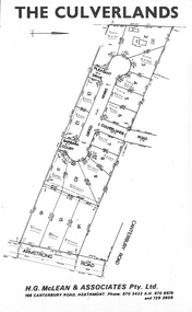
Document, Subdivision Plan - The Culverlands Estate, Heathmont, Victoria (undated, circa 1968)
Map of residential allotments for sale, with handwritten pricing notations and some marked "Sold". Subdivision includes Culverlands Road, Swain Court, Pleasant Drive, Barbara Court, and Armstrong Road, Heathmont. Agent - H.G. McLean & Associates Pty. Ltd., 166 Canterbury Road, Heathmont Vic., 3135, Telephones : 870-3422 A/hrs 870-5879 and 729-2809. -
 Greensborough Historical Society
Poster - Planning Document, City of Heidelberg et al, Subdivision Plan # H 41 - Crown portion 8, Parish of Keelbundoora - Yallambie, and Crown Portion 9, Parish of Keelbundoora, 1922-1967
Planning Document: Subdivision Plan # H 41 Side 1, Crown portion 8, Parish of Keelbundoora - Yallambie Road, Allima Avenue, Koolya Court, Ekam Court (Jennings Estate). Side 2: Crown Portion 9, Parish of Keelbundoora consist of 5 small subdivision sheets: 1. Somers Avenue, Stewart Terrace, Toubay Street and Railway Place (no date); 2. Somers Avenue, Maxwell Street, Greensborough Road, 1924; 3. Heidelberg Avenue, Golf Avenue, St Andrews Avenue (no date); 4. Birdwood Avenue, May Street (no date); 5. Strathallan Road 1924.An example of hard copy subdivision plans from the Greensborough area. Mainly from the Shire of Diamond Valley era (1964-1994).Plan (2 sided) mounted on heavy card. Stamped and handwritten Council permissions, dates and other details.subdivision plans, city of heidelberg, yallambie, macleod, greensborough -
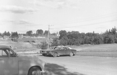 Ringwood and District Historical Society
Photograph, Looking from parking area in front of Parkwood High School towards Wonga Road over new subdivision, North Ringwood, 1981
Written on back of photograph, "24.4.81 Looking from parking area in front of Parkwood High School towards Wonga Road over new subdivision. In the area seen there are six new courts under construction. Three months ago there was nothing there." -
 Ringwood and District Historical Society
Document - Folder, Land Sale - Monterey Park Subdivision, Warrandyte Road, Ringwood North, Vic. - 1981
Foolscap manilla folder containing double-sided flyer advertising residential subdivision development, including outline of local facilities and services, with locality map and layout of Monterey Park streets. Subdivision includes Parkwood High School, Tortice Drive, Heape Way, Appleberry Place, Stringybark Court, Conifer Court, Crawley Grove, Monterey Close (later Monterey Place), Lucy Place, Middlebrook Drive, Gahnia Close, Glanfield Court, Cone Close, Jull Parade, Pinus Close (later Pinetree Court), Radiata Close, Old Warrandyte Road, and entry from Warrandyte Road. Vendor - Jennings Industries Limited, 690 Springvale Road, Mulgrave, 3170, Phone 5618000. A4 enclosures with tables showing each allotment List Price, Builders Price, Cash Price and Terms Price. Information page headed "Form of Restrictive Covenant to be incorporated in Transfer" specific to Certificates of Title. Restrictive Covenant (summary): (Name/s) "... will not erect or construct or cause to be erected or constructed on the land hereby transferred (a) Any front boundary fence, other than a fence which does not exceed one metre in height unless the same is set back as least 1.5 metres from the front boundary and the same is effectively screened from that boundary by the planting of trees, shrubs or plants. (b) Any side boundary fence other than a fence which is set back at least 1.5 metres from the front boundary on which does not exceed 1 metre in height within 1.5 metres of the front boundary. (c) For a period of 5 years from the date hereof, any building on the said land unless and until the Plans and Specifications thereof have first been approved by the said Residential Developments Pty. Limited. (d) For a period of 2 years from the date hereof whilst the said land remains vacant any Signboard or Notice advertising the sale of the said lot or any other lot. These covenants shall appear on the Certificate of Title to issue for the said land and run with the land." -
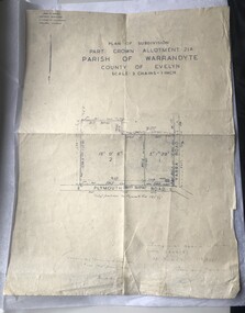 Luther College
Map, Plan of Subdivision, 1957
This map shows the original subdivision of land on the corner of Plymouth Road and Yarra Road. The land previously belonged to Phillip Brucker, who used the property as a small farm. Brucker offered his land at a reduced price to the Lutheran Church, who were seeking a location for their new secondary school endeavour.This is the oldest map of Luther Collegemap, building plans -
 Bacchus Marsh & District Historical Society
Map, Subdivision of the Manor House Property Bacchus Marsh c.1908
This land sales plan shows allotments of land offered for sale in the inner township area of Bacchus Marsh in 1908. The land put up for sale was from the estate of the late Mr and Mrs J.E. Crook. That being James Elijah Crook and his wife Harriet, (nee Athorn). The Crooks had been resident in Bacchus Marsh since the 1840s and were prominent members of the community. They were prominent in the business, social and civic affairs of the town and district. In the 1850s the Crooks acquired the Manor House and nearby land once owned by the Bacchus family. James Crook died in 1889. When Harriet Crook died in February 1908 their estate was offered for sale. This included the large stone home known as the Manor House and various parcels of land including around 50 allotments of land near the Manor House, bounded by Young, Lerderderg, Crook and Main Streets. Most of these allotments of land were sold in October 1908. The Manor House itself was passed in at the sale and continued to be owned by the Crook family for several decades after 1908.A single page map on a single page of a bound volume of maps. The map shows portions of land for sale from the subdivision of the Manor House property in Bacchus Marsh in 1908. The names of most of the buyers of the portions of land have been hand-written into the various allotments they purchased. The maps are pasted into a bound volume containing 76 maps or plans in total. High resolution digital image stored on BMDHS computer network. bacchus marsh victoria maps, land sales bacchus marsh, manor house bacchus marsh, crook family bacchus marsh -
![Map, Plan of Subdivision of Crown Portion 23 & parts 24-25, Parish of Korkuperrimul [1900s?]](/media/collectors/5e461d8021ea67224c82f2a1/items/675fe058304668462205d4fb/item-media/675fe0ef304668462205d7d6/item-fit-380x285.jpg) Bacchus Marsh & District Historical Society
Bacchus Marsh & District Historical SocietyMap, Plan of Subdivision of Crown Portion 23 & parts 24-25, Parish of Korkuperrimul [1900s?]
The Parish of Korkuperrimul includes a significant section of the township of Bacchus Marsh and extends in western and northern directions from the township area. The date of the subdivision indicated on this plan has not been established. The engineer's stamp on the drawing shows the firm of Muntz and Muntz who were operating under that name in the early part of the 20th century.A single page paper map showing 20 blocks of land for sale in the Parish of Korkuperrimul. Scale 100 feet to 1 inch. The map is pasted into a bound volume containing 76 maps or plans in total. High resolution digital image stored on BMDHS computer network. Stamped: 'Muntz & Muntz Civil Engineers, Architects & Surveyors, Trustees Chambers ?? Cor Collins Street and Bank Placeland sales bacchus marsh, bacchus marsh victoria maps, land sales korkuperrimul parish -
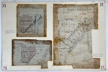 Greensborough Historical Society
Poster - Planning Document, City of Heidelberg, Subdivision Plan # 35 - Parish of Keelbundoora, Crown Portion 16, Watsonia, 1918
Subdivision Plan # 35 Parish of Keelbundoora, Crown Portion 16: 3 plans on one sheet. Plan 1: Lambourn Road, Boger Street, Kenmare Street, Greensborough Road, Devonshire Road, Watsonia (stamped "Superseded"). Plan 2: an update of plan 1. Plan 3: Also Lambourn Road, Boger Street, Kenmare Street, dated 1918, Shire of Heidelberg.An example of hard copy subdivision plans from the Greensborough area. Mainly from the Shire of Diamond Valley era (1964-1994).3 Plans (single sided) mounted on heavy card. Stamped and handwritten Council permissions, dates and other details. Plan 1 has been stamped in red "SUPERCEDED" and overwritten by hand "Cancelled".subdivision plans, city of heidelberg, greensborough, main street greensborough, shire of heidelberg, watsonia -
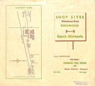 Ringwood and District Historical Society
Flyer, Ringwood Mail, Retail Subdivision Brochure - Plan of New Shop Sites, Ringwood, Victoria. - circa 1950
Double sided folded page advertising shop sites in Whitehorse Road, Ringwood, with locality plan, price list, terms of sale, summary of local facilities and services, and diagram showing layout of 9 retail allotments for sale. These sites were originally zoned as residential as part of the 1926 "Olive Grove Estate" subdivision. (See Vicorian Collections Reference 5169). The 9 new shops were later allocated street numbers 58 to 64 Whitehorse Road, Ringwood.Locality plan showing shop sites for sale on Whitehorse Road, Ringwood, between New Street and Olive Grove. Sole Agents: Ringwood Real Estate Co., Station Entrance, Ringwood, (Telephone) WU6661, WU6662. -
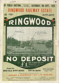 Ringwood and District Historical Society
Flyer, Subdivision Advertisement - Ringwood Railway Estate Public Auction - 1923
Refer also to Reg. No. 5185 for Ringwood Railway Estate final section release (August 1924)Folded double-sided brochure advertising 85 residential allotments and brick cemented villa - Ringwood Railway Estate Public Auction on Saturday 8th September, 1923, with town photographs, location map, terms of sale, and summary of local features and services.Subdivision includes Whitehorse Road, Bon View Avenue, Grant Crescent, Heatherbrae Avenue, Burwood Avenue, and Sherbrooke Avenue. (Agents) Knight & Harwood, 315 Collins Street, Melbourne, Phones Central 10615, 10616, in conjunction with J.B. McAlpin, Opposite Railway Station, Ringwood, Phone Ringwood 7. -
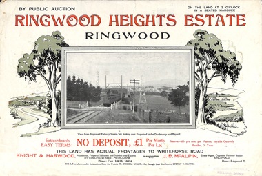 Ringwood and District Historical Society
Flyer, Subdivision Advertisement - Ringwood Heights Estate Public Auction - March, 1924
Refer also to Reg. No. 5185 for Ringwood Heights Estate final section release (August 1924)Folded double-sided brochure advertising Ringwood Heights Estate Public Auction on Saturday March 1, 1924, with town photographs, location map, terms of sale, and summary of local features and services.Subdivision includes Whitehorse Road, Bon View Avenue, Grant Crescent, Hillcrest Avenue, Heatherbrae Avenue, Margaret Street, and Mary Street. (Agents) Knight & Harwood, 315 Collins Street, Melbourne, Phones Central 10615, 10616, in conjunction with J.B. McAlpin, Opposite Railway Station, Ringwood, Phone Ringwood 7. -
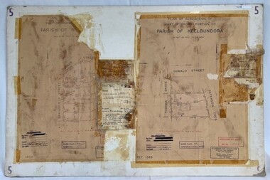 Greensborough Historical Society
Poster - Planning Document, City of Heidelberg et al, Subdivision Plan # 5 - Crown Portion 17, Parish of Nillumbik, and Crown Portion18, Parish of Keelbundoora, 1925-1972
Subdivision Plan # 5 - Side 1: Crown portion [unknown - damaged], Parish of Nillumbik, Springfield Street, Turner Street Briar Hill,1963 amended 1972 and Crown Portion17, Parish of Keelbundoora: Thoona Grove, Donald Street. Paterson Crescent Greensborough, 1963 amended 1967. Side 2: Parish of Keelbundoora, Crown Portion 18: Boyd Street, Kempston Street Greensborough 1925; and Main Street Greensborough. An example of hard copy subdivision plans from the Greensborough area. Mainly from the Shire of Diamond Valley era (1964-1994).Plan (2 sided) mounted on heavy card. Stamped and handwritten Council permissions, dates and other details.subdivision plans, city of heidelberg, greensborough, briar hill, main street greensborough -
 Ringwood and District Historical Society
Map, Subdivision Plan - House and 13 residential allotments fronting Fremont Street Ringwood, Vic., and George Street (later Tudor Court), Heathmont, Vic. - Undated, circa 1922
Hand-drawn map on cardboard backing.Formed road with concrete kerbing. Water available to each block. No. of subdivision A139880 73/419. Part of Certificate of Title Vol 5323 Fol 539. Real estate sales notations on some allotments include price. Heading also includes address and phone number of H. Willis, Fremont Street Ringwood - WU6073.