Showing 427 items
matching topography
-
 Lakes Entrance Historical Society
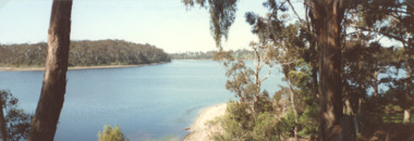
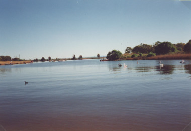
Photograph - Mill Point and Blackfellows Arm, Lake Tyers Victoria, 2000
Colour photograph of part of Lake Tyers from Mill Point showing Toorloo Arm in centre distance Blackfellow's Arm to the left Lake Tyers Victoria. Also a second photograph taken of Lake Tyers from Mill Point showing Blackfellows Arm in centre and Bills Arm on left waterways, topography -
 Lakes Entrance Historical Society
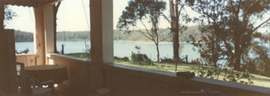
Photograph - Views from Mill Point house, Lake Tyers Victoria, 2000
Colour photograph taken from Mill Point house showing Lake Tyers Victoria. waterways, topography -
 Lakes Entrance Historical Society
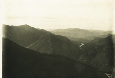
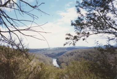
Photograph - Snowy River at Glenantipy, Rev John Flynn, 1906 c
Photographic proof on light cardBlack and white photograph of view of Snowy River from the lookout at Gelantipy Victoriatopography, waterways -
 Lakes Entrance Historical Society
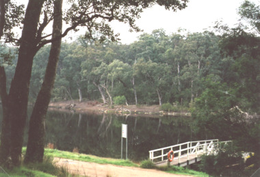
Photograph, M Holding, Northern End Lake Tyers at Nowa Nowa Victoria 2014, 1/06/2014 12:00:00 AM
The area was the port of Nowa Nowa during early years of settlement and timber industry.Colour photograph of flating jetty at top of North Arm of Lake Tyers at Nowa Nowa Victoriatopography, gippsland lakes -
 Lakes Entrance Historical Society
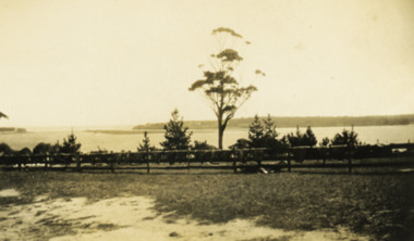
Photograph - Lake Tyers, 1920 c
Black and white photograph of Lake Tyers taken from Aboriginal Station showing island in lake and entrance in distance with animal hides drying along the fence sheep and cattle Lake Tyers Victoriawaterways, topography -
 Lakes Entrance Historical Society
Photograph - Lake Bunga, 1920 c
Black and white photograph of Lake Bunga looking upstream from entrance with remains of old tramline in distance Lake Bunga Victoria waterways, topography -
 Lakes Entrance Historical Society
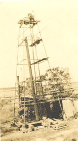
Photograph - Drilling rig, North Arm Lakes Entrance Victoria, 1926
Black and white photograph of drilling rig Government number 2 Bore at North Eastern side of North Arm bridge with Rigby Island and Hummocks, Lake and Princes Highway in background Lakes Entrance Victoriaoil and gas industry, topography -
 Lakes Entrance Historical Society
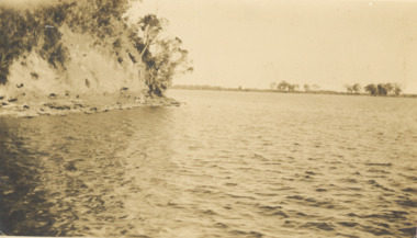
Photograph - Steep bluff, Mission Lake Tyers Victoria, 1926 c
Sepia toned photograph of steep bluff opposite jetty at Mission Lake Tyers Victoriawaterways, topography -
 Lakes Entrance Historical Society
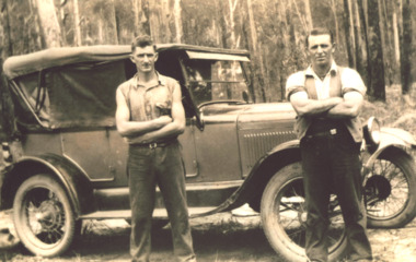
Photograph - T Model Ford, Charles Pettman and William Henry Flukes, 1936 c
The T Model Ford cost him 28 poundsBlack and white photograph of Charles Pettman and William Henry Flukes standing beside Charles T Model Ford on a forest track East Gippslandvehicles, topography -
 Lakes Entrance Historical Society
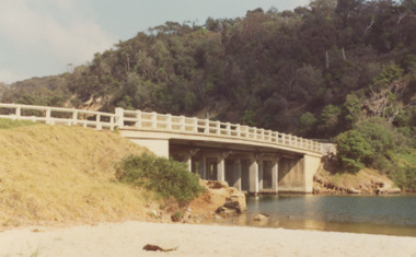
Photograph - North Arm bridge Lakes Entrance Victoria, M Fish, 1970 c
concrete bridge over North Arm taken from Eastern side of bridge southern shore of North Arm Lakes Entrance Victoria. Bridge built 1916 to 1917 demolished after opening of new bridgeColour photograph of concrete bridge over North Arm taken from Eastern side of bridge southern shore of North Arm Lakes Entrance Victoriabridges, topography -
 Lakes Entrance Historical Society
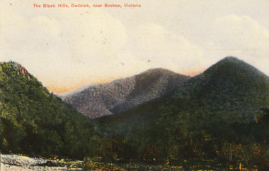
Postcard - Black Hills Deddick, WPT series, 1908 c
Letter on back to Miss Evans of Lima East via BenallaHand coloured postcard showing view of Black Hills Deddick VictoriaThe Black Hills Deddick near Buchantopography, correspondence -
 Lakes Entrance Historical Society
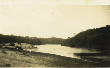
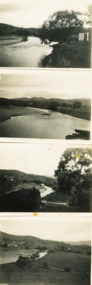
Photograph - Buchan River, M D Fish, 1/09/1933 12:00:00 AM
Permission required from LERHS for copyingBlack and white photographs of Buchan River below the bridge, Buchan Victoriawaterways, topography -
 Lakes Entrance Historical Society
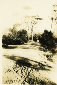
Photograph - Jemmys Point roadway, 1924
View of road down Jemmys Point, hummocks and lake just visible in far distance Lakes Entrance Victoriaroads and streets, topography -
 Lakes Entrance Historical Society
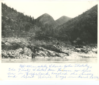
Photograph - Snowy River Buchan, 1977 c
Polish scientist explorer Dr. Lhotsky explored the Australian Alps south of Mt Kosciusko (not named at that date)as far as McKillops Bridge (unnamed then) between 1834 and 1839. His claims were largely ignored he being labelled imposter and humbug but recent research indicates his rightful place amongst Victorias early explorersBlack and white photograph of Snowy River at Suggan Buggan VictoriaApproximately where John Lhotsky the first white man known to have been in Gippsland reached the Snowy and spent three days in March 1834topography, rivers -
 Lakes Entrance Historical Society
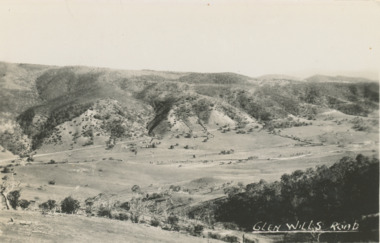
Postcard - Glen Wills Victoria, 1940 c
For over 20 years from 1893 gold mining was undertaken in the mountains around Glen Wills.Black and white postcard looking towards the Glen Wills Road situated between the valley and steep hills taken in summer Glen Wills Victoriasettlement, topography -
 Lakes Entrance Historical Society
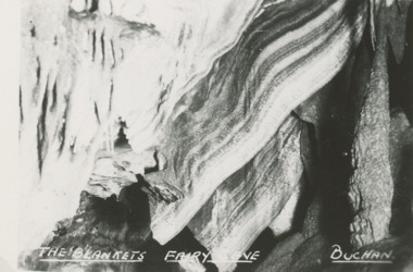
Postcard - Fairy Cave, Buchan Victoria, 1940 c
Also five postcards of caves donated by Teena Daley 04543.1, .2, .3, .4, .5 size 6.5 x 9 cmSmall black and white postcard of The Blankets, Fairy Cave, Buchan Victoria. Plus 7 other photos of various cavestopography, parks -
 Lakes Entrance Historical Society
Photograph - Mitchell River, Eagle Point Victoria
Colour photograph of Mitchell River at entrance to silt jetties near Eagle Point Victoria. Plus two other photos of Mitchell River at Eagle Point waterways, topography -
 Lakes Entrance Historical Society
Photograph - Mitchell River, Glenaladale Victoria, 1994 c
Colour photograph of Mitchell River from Billy Goat Bend showing steep gorge between heavily forested high banks. Glenaladale Victoria. Also two photographs of U3A Geology group on track overlooking Mitchell River and black and white photograph of Billy Goat Bend donated by Lakes Post Newspaper 6 January 2010 topography, rivers -
 Lakes Entrance Historical Society
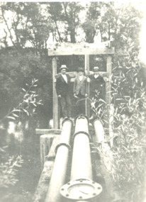
Photograph - mining in Gippsland Victoria, 1920 c
Black and white photograph showing three men standing at three water pipes beside a waterway which appears to be an abandoned pumping station perhaps associated with mining in Gippsland Victoriatopography, transport -
 Lakes Entrance Historical Society
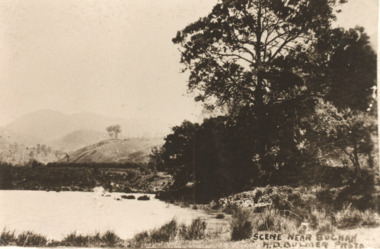
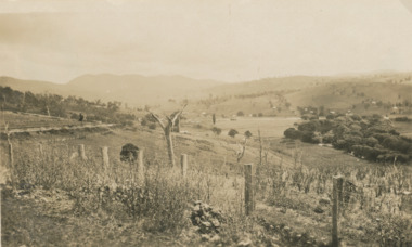
Postcard - Buchan Victoria, H D Bulmer, 1915 c
Sepia toned copy of postcard showing waterway with mountains in distance at Buchan Victoria. Also a second identical photographScene near Buchanagriculture, topography -
 Lakes Entrance Historical Society
Postcard, H D Bulmer, Little River Falls , Wulgulmerang near Buchan Victoria, 1915 c
Black and white postcard of the countryside and hills surrounding township of Buchan VictoriaView of Buchanagriculture, topography -
 Lakes Entrance Historical Society
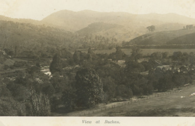
Photograph - Buchan Victoria, 1925
Sepia toned photograph of view approaching Buchan Victoriatopography, exploration -
 Lakes Entrance Historical Society
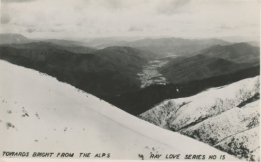
Photograph - High Country looking toward Bright, Victoria c1940, Ray Love series, 1940 c
Black and white photograph of Alps looking toward Bright, snow of closer heights, Alps VictoriaTowards Bright from the Alps Ray Love series No 15high country of victoria and nsw, topography -
 Lakes Entrance Historical Society
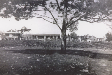
Photograph, Toorloo House guesthouse Lake Tyers Victoria, 1935 c
Large house on right has been demolished small detached building on left remains Lake Tyers Victoria.Black and white photograph of Toorloo House guesthouse at Bills Arm owned by Bills family. Also two similar black and white photographs of Toorloo House topography, guesthouses -
 Lakes Entrance Historical Society
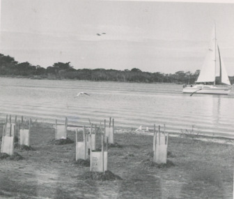
Photograph, Lakes Post Newspaper, Shaving Point Metung Victoria, 1/05/1992 12:00:00 AM
Black and white photograph of newly planted shrubs on shoreline, sailing boat on lake, timbered land opposite, taken from Shaving Point Metung Victoriawaterways, topography -
 Lakes Entrance Historical Society
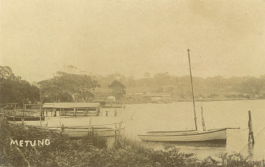
Photograph, Bancroft Bay Metung Victoria, 1900 c
Sepia toned photograph taken around Bancroft Bay shoreline showing jetties, boatshed, timbered hill beyond taken from Shaving Point Metung Victoriawaterways, topography -
 Lakes Entrance Historical Society
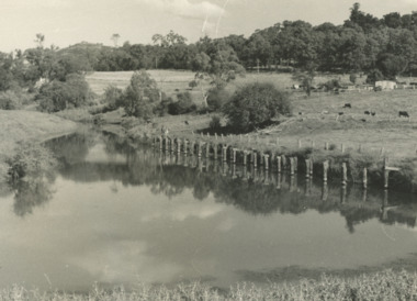
Photograph, G Legg Bairnsdale, Mossiface wharf at Mossiface Victoria, c1980
Black and white photograph of the remains of Mossiface wharf on the Tambo River at Mossiface Victoria c1980 topography, rivers -
 Lakes Entrance Historical Society
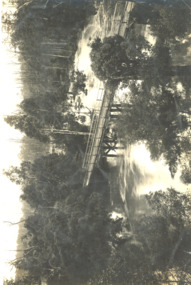
Postcard, Segerberg and Bulmer, Hospital Creek East Gippsland Victoria, 1913 c
Photograph Segerberg and Bulmer in partnership 1908 - 1913Black and white postcard showing heavily timbered country surrounding a timber bridge over the flooded Hospital Creek East Gippsland Victoriaocean, topography -
 Bendigo Military Museum
Photograph - 4th Field Survey Squadron Adventurous Training, Wilpena pound, Flinders Ranges, SA, 1989
This is a set of 55 photographs of a 4th Field Survey Squadron adventurous training held at Wilpena pound, in the Flinders Ranges of South Australia in 1989. It is evident the training focussed on teamwork, leadership, abseiling, rock climbing, field craft and living off the land survival skills. Elements from units of the Army Reserve also participated in the training. In this photo set, one of 4th Field Survey’s sections participated in abseiling and trekked to the highest mountain in the Flinders Ranges – St. Mary’s Peak. Refer to item 6552.43P for black & white photographs taken during the adventurous training exercise.This is a set of 55 photographs of 4th Field Survey Squadron personnel undergoing adventurous training held at Wilpena pound, in the Flinders Ranges of South Australia in 1989. The colour photographs are on 35mm negative film and are part of the Army Survey Regiment’s Collection. The photographs were scanned at 96 dpi. .1) & 2)- Photo, colour, 1989. Base camp. WO1 Bill Griggs 2nd from left, remainder unidentified. .3) - Photo, colour, 1989. Old homestead inside Wilpena Pound. SPR Cheryl Deluca-Cardillo, 2nd from left, remainder unidentified. .4) - Photo, colour, 1989. Wilpena Pound topography. .5) - Photo, colour, 1989. Abseiling activities, unidentified personnel. .6) & .7) - Photo, colour, 1989. Flinders Ranges topography. .8) - Photo, colour, 1989. Abseiling activities. L to R: SSGT Max Coletti, SGT Stu Symonds. .9) - Photo, colour, 1989. Abseiling activities, unidentified personnel. .10) - Photo, colour, 1989. Flinders Ranges topography. .11) - Photo, colour, 1989. Abseiling activities. L to R: unidentified, CPL Michelle Griffith, SGT Stu Symonds. .12) - Photo, colour, 1989. Abseiling activities. L to R: unidentified, SPR Andrew Quin, SGT Laurie Justin, SGT Stu Symonds. .13) - Photo, colour, 1989. Abseiling activities. L to R: SGT Stu Symonds SGT Laurie Justin. .14) - Photo, colour, 1989. Abseiling activities. L to R: unidentified, SGT Stu Symonds. .15) - Photo, colour, 1989. Abseiling activities. SGT Laurie Justin. .16) - Photo, colour, 1989. Abseiling activities. SGT Stu Symonds. .17) & .18) - Photo, colour, 1989. Abseiling activities. SPR Cheryl Deluca-Cardillo. .19) - Photo, colour, 1989. Abseiling activities. L to R: SPR Cheryl Deluca-Cardillo, unidentified. .20) - Photo, colour, 1989. Abseiling activities. SSGT Max Coletti. .21) - Photo, colour, 1989. Abseiling activities. SPR Andrew Quin. .22) - Photo, colour, 1989. Abseiling activities. CPL Michelle Griffith. .23) - Photo, colour, 1989. Abseiling activities. CPL Michelle Griffith. .24) - Photo, colour, 1989. Flinders Ranges topography, unidentified personnel. .25) - Photo, colour, 1989. Flinders Ranges topography, unidentified SGT. .26) to .30) - Photo, colour, 1989. Flinders Ranges topography. .31) - Photo, colour, 1989. Flinders Ranges topography, unidentified personnel. .32) & .33) - Photo, colour, 1989. Flinders Ranges topography. L to R: unidentified, CPL Michelle Griffith, SGT Stu Symonds, CPL Roger Graf, SSGT Max Coletti, SGT Laurie Justin. .34) - Photo, colour, 1989. St. Mary’s Peak. L to R: unidentified, CPL Michelle Griffith, CPL Steve Nokes, SGT Stu Symonds. .35) - Photo, colour, 1989. St. Mary’s Peak. SGT Stu Symonds. .36) & .37) - Photo, colour, 1989. St. Mary’s Peak. CPL Steve Nokes. .38) - Photo, colour, 1989. Flinders Ranges topography. .39) - Photo, colour, 1989. St. Mary’s Peak. SGT Laurie Justin. .40) - Photo, colour, 1989. St. Mary’s Peak. SPR Cheryl Deluca-Cardillo. .41) - Photo, colour, 1989. St. Mary’s Peak. SPR Andrew Quin. .42) - Photo, colour, 1989. Flinders Ranges topography, SGT Stu Symonds. .43) - Photo, colour, 1989. Social activities. L to R: unidentified (x6), CPL Perry Langeberg, SGT Laurie Justin. .44) - Photo, colour, 1989. Social activities. L to R: CPL Perry Langeberg, SGT John Zuringer, SGT Laurie Justin, SGT Mick Hogan, unidentified, SGT Stu Symonds. .45) - Photo, colour, 1989. Social activities. L to R: unidentified (x6), CPL Perry Langeberg, SGT John Zuringer. .46) - Photo, colour, 1989. Social activities. L to R: CPL Jamie McRae, SGT Laurie Justin, SGT Mick Hogan, unidentified, SGT Stu Symonds, SPR Cheryl Deluca-Cardillo, WO1 Bill Griggs. .47) - Photo, colour, 1989. Social activities. L to R: SGT Laurie Justin, unidentified, CPL Steve Nokes, SGT Stu Symonds, SPR Cheryl Deluca-Cardillo, WO1 Bill Griggs, unidentified (x2). .48) - Photo, colour, 1989. Social activities. L to R: CPL Steve Nokes, WO1 Bill Griggs, SPR Cheryl Deluca-Cardillo, unidentified (x2), CPL Steve Ellis, CPL Michelle Griffith, SGT Gill Park. .49) - Photo, colour, 1989. Social activities. L to R: CPL Perry Langeberg, SGT John Zuringer, CPL Jamie McRae, SGT Laurie Justin, SGT Mick Hogan, unidentified, SGT Stu Symonds. .50) - Photo, colour, 1989. Sheep cooking in fire pit. L to R: WO2 Peter Symmans, unidentified (x5), CPL Steve Ellis. .51) - Photo, colour, 1989. Sheep cooking in fire pit. L to R: WO2 Peter Symmans, unidentified. .52) - Photo, colour, 1989. Sheep cooking in fire pit. Unidentified personnel. .53) - Photo, colour, 1989. Cooked sheep removed from fire pit. L to R: unidentified. WO2 Peter Symmans, unidentified. .54) - Photo, colour, 1989. Cooked sheep removed from fire pit. L to R: CPL Michelle Griffith, SGT Gill Park, unidentified, SSGT Max Coletti, unidentified, SPR Cheryl Deluca-Cardillo. .55) - Photo, colour, 1989. Cooked sheep removed from fire pit. L to R: unidentified, CPL Michelle Griffith, WO2 Peter Symmans..1P to .55P – There are no personnel identified. ‘1989 ADV TRAINING’ annotated on negatives sleeve.royal australian survey corps, rasvy, 4 fd svy sqn -
 Bendigo Military Museum
Photograph - 4th Field Survey Squadron – Operation ARIGHT 93, Queensland, 1993
This is a set of 42 photographs taken during 4th Field Survey Squadron’s deployment on Operation ARIGHT 93 in North Queensland from the 30th of August to the 8th of October 1993. The Survey Field Completion area of operations was Weipa near the top end of the Cape York Peninsula. Survey parties conducted field checking of topographic maps covering Bamaga, Heathlands, Weipa, Lockhart River and Strathgordon in Perentie 110 Series Survey variant FFR Land Rovers. Hand-held Trimble and Magellan GPS receivers were used to assist with navigation and to position remote isolated features. Three Bell Kiowa LOH helicopters provided by 162 Recce Sqn supported field checking operations. Supplementary and Vital Asset Protection photography was taken by air camera operators in AAAvn Nomad aircraft from 173 Survl Sqn fitted with an RC10 aerial camera.This is a set of 42 photographs taken in 1993 durin8g 4th Field Survey Squadron’s deployment on Operation ARIGHT in North Queensland. The colour photographs are on 35mm negative film and are part of the Army Survey Regiment’s Collection. The photographs were scanned at 96 dpi. .1) - Photo, colour, 1993. Survey party in Perentie 110 Series Land Rover navigates through Cape York Peninsula sand hills. .2) - Photo, colour, 1993. Cape York Peninsula sand hills. .3) - Photo, colour, 1993. Cape York Peninsula Island. .4) - Photo, colour, 1993. Survey party in Perentie 110 Series Land Rover enters a Cape York Peninsula beach. .5) - Photo, colour, 1993. SPR Kim Baker takes a break on a Cape York Peninsula beach. .6) - Photo, colour, 1993. L to R: MAJ Andy Cordova (USA Exchange) from the Army Survey Regiment and unidentified civilians. .7) to .14) - Photo, colour, 1993. Cape York Peninsula topography. .15) - Photo, colour, 1993. Unidentified surveyor in Bell Kiowa LOH helicopter. .16) - Photo, colour, 1993. Bell Kiowa LOH helicopter circles base camp. .17) to .18) - Photo, colour, 1993. Cape York Peninsula topography. .19) - Photo, colour, 1993. Vehicle convoy taking a break. L to R: LT John Bath (Detachment OC), unidentified (x2), SPR Chris Pearse. .20) - Photo, colour, 1993. Vehicle convoy taking a break. .21) - Photo, colour, 1993. Vehicle convoy ready to go. SPR Chris Pearse. .22) - Photo, colour, 1993. Vehicle convoy on the move. .23) - Photo, colour, 1993. Cape York Peninsula topography. .24) - Photo, colour, 1993. Unidentified personnel. .25) - Photo, colour, 1993. SGT Neale ‘Tex’ Houston. .26) - Photo, colour, 1993. Ground below a Bell Kiowa LOH helicopter .27) - Photo, colour, 1993. L to R: SPR Mark Sinderberry and CPL Stuart Adrain in a Bell Kiowa LOH helicopter. .28) & .29) - Photo, colour, 1993. Ground below a Bell Kiowa LOH helicopter. .30) - Photo, colour, 1993. Base camp viewed from a Bell Kiowa LOH helicopter. .31) - Photo, colour, 1993. Cape York Peninsula topography in recovery after burn-off. .32) & .33) - Photo, colour, 1993. SPR Kim Baker contemplates crossing this bridge in his Land Rover. .34) - Photo, colour, 1993. SPR Kim Baker takes a break next to a billabong. .35) - Photo, colour, 1993. Survey party in Perentie 110 Series Land Rover crosses a creek. .36) - Photo, colour, 1993. Cape York Peninsula bush fire in distance. .37) - Photo, colour, 1993. Survey party in Perentie 110 Series Land Rover traverses a sand hill. .38) - Photo, colour, 1993. SPR Kim Baker. .39) - Photo, colour, 1993. Cape York Peninsula bush fire. .40) - Photo, colour, 1993. Cape York Peninsula topography. .41) & .42) - Photo, colour, 1993. Cape York Peninsula sand hills..1P to .42P – There are no personnel identified. ‘1993 OP ARIGHT’ annotated on negative sleeve.royal australian survey corps, rasvy, 4 fd svy sqn, op aright 93