Showing 536 items
matching vegetation
-
 Lakes Entrance Historical Society
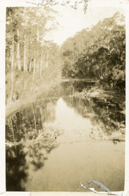
Photograph - North Arm, 1924
Black and white small format photograph showing upper reaches of North Arm. Reflections of vegetation on water. Lakes Entrance Victoriatopography, waterways -
![Cumberland Creek, near Point Sturt / [by] Nicholas Caire, circa 1876](/media/collectors/550653872162f11fb04854aa/items/57834713d0cdd1176c71111b/item-media/57834799d0cdd1176c71e113/item-fit-380x285.jpg) Kew Historical Society Inc
Kew Historical Society IncPhotograph, Anglo-Australasian Photographic Company, Cumberland Creek, near Point Sturt, c. 1876
Nicholas Caire was born on Guernsey in the Channel Islands in 1837. He arrived in Adelaide with his parents in about 1860. In 1867, following photographic journeys in Gippsland, he opened a studio in Adelaide. From 1870 to 1876 he lived and worked in Talbot in Central Victoria. In 1876 he purchased T. F. Chuck's studios in the Royal Arcade Melbourne. In 1885, following the introduction of dry plate photography, he began a series of landscape series, which were commercially successful. As a photographer, he travelled extensively through Victoria, photographing places few of his contemporaries had previously seen. He died in 1918. Reference: Jack Cato, 'Caire, Nicholas John (1837–1918)', Australian Dictionary of Biography.An original, rare photograph from the series 'Views of Victoria: General Series' by the photographer, Nicholas Caire (1837-1918). The 60 photographs that comprise the series were issued c. 1876 and reinforced a neo-Romantic view of the Australian landscape to which a growing nationalist movement would respond. Nicholas Caire was active as a photographer in Australia from 1858 until his death in 1918. His vision of the Australian bush and pioneer life had a counterpart in the works of Henry Lawson and other nationalist poets, authors and painters.‘Cumberland Creek, near Point Sturt’ : Views of Victoria (General Series) No.59 : Albumen silver photograph | Photo on card with Title and Description on reverse | Mounted 24 x 30 cm; Photo 12 x 17 cm.On Reverse: ‘The Cumberland Creek is so named from the close resemblance it bears to the place bearing that name in the mother country. The present illustration represents the precipices and hills which surround the Cumberland Creek. The soil around the hills is mostly sandstone rubble, hence the only vegetation identical with the spot is the inevitable sword grass and salt scrub, which frequently exist where no other vegetation can be found.’nicholas caire (1837-1918), landscape photography -
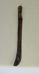 Orbost & District Historical Society
machete, c. early to mid 20th century
Possibly used in the farming industry for slashing vegetation.A large metal knife with a wooden handle. machete-knife -
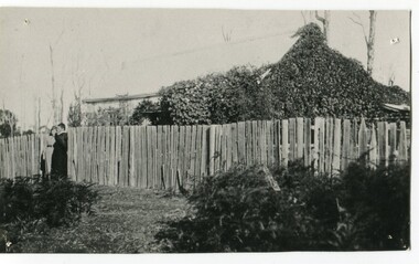 Orbost & District Historical Society
black and white photograph, late 19th century - early 20th century
This house belonged to the Ashby family. Roy Ashby, son of James Rowland Ashby and Edith Annie Hall, was born on 21 Nov 1892 in Orbost. Victoria. Australia and died in 1942 in Orbost. Victoria. Australia at age 50. Roy married Elsie May Stephens, daughter of James Stephens and Sarah Taylor, in 1920 in Victoria.Australia. Elsie was born on 15 Sep 1898 in Beaconsfield Tasmania.Australia and died in 1974 in Orbost Australia at age 76. Their children were: Roy Ashby, William Henry Ashby, Cordelia Valma Ashby and Edith Ashby. .The Ashby family was one of the early settlers in Orbost at Newmerella.A black / white photograph of a house surrounded by a tall timber fence with. The house has vegetation growing over it. There are two people standing against the fence.ashby-orbost -
 Whitehorse Historical Society Inc.
Photograph, Yarran Dheran Reserve
Black and white photo of creek, track and vegetation in Yarran Dheran Reserve|This record was wrongly allocated NP2717. Now corrected. Companion photo at NP2716yarran dheran -
 Kew Historical Society Inc
Photograph - Picnic beside the Yarra at Kew, 1938
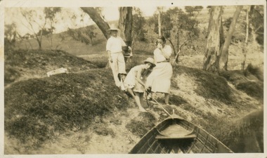
Rowing on the River Yarra was a recreational traditional pastime for the people of Kew and Melbourne since settlement in the 1830s. Later in the century, boats were frequently hired from boathouses.Three people beside the Yarra. Teenage girl (?) pulling a row boat towards the shore. Photo taken from boat. Sparse riverside vegetation. Reverse: "Jan 38"river yarra, recreation -- rowing -
 Lakes Entrance Historical Society
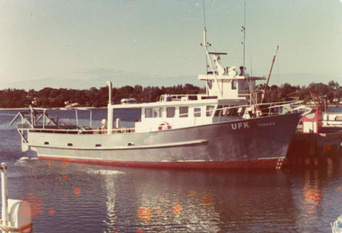
Photograph - Tamara, 1980
Colour photograph of the scallop fishing boat Tamara at the jetty at Bullock Island, glimpse of cottages amongst vegetation on hummocks in background. Lakes Entrance Victoriaboats and boating, fishing industry, waterways -
 Lakes Entrance Historical Society
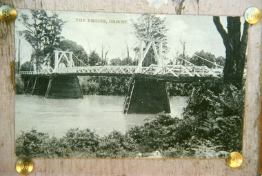
Photograph - Bridges, 1920
First bridge over the Snowy River at Orbost built 1891Black and white photographic print showing early first bridge across Snowy River thick vegetation along river banks. Orbost Victoriabridges, waterways -
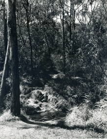
 Greensborough Historical Society
Slide - Photograph, John Ramsdale, Plenty River, upstream from Gorge: Slide 42, 1990s
Photograph shows creek bed with vegetation, upstream from Plenty Gorge.Part of the John Ramsdale collection of slides and audio visual material.Colour photograph scanned from slide.No caption. Printed maker's mark on slide "Kodak Kodachrome Slide"plenty gorge, plenty river, mernda -
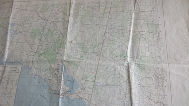 Peterborough History Group
Map - Government map, Government Printer, Port campbell, 1957
Aerial survey map showing roads, vegetation and other landscape features.Significant because it shows the detail of the region in 1957Original 1957 State Aerial Survey Map of Port Campbell region, including Peterboroughpeterborough, aerial survey map, maps, port campell -
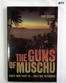 Bendigo Military Museum
Book, Don Dennis, The Guns of Musdui, 2006
Book, soft cover. Front cover has an image of jungle vegetation & coastline. Print is gold & red ink. 255 pages, illustrations & some maps.Len Burke Donated by Len Burkebooks, military, history -
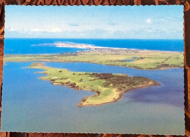 Phillip Island and District Historical Society Inc.
Photographs, Victoria Conservation Trust, Churchill Island, 1980s
3 coloured postcards and 8 coloured photographs of scenes on Churchill Island including an aerial view, homestead, outbuildings, vegetation, views, cairn and coastal scenes.Postcards say Churchill Island, Victoria. Victoria Conservation Trustchurchill island, churchill island heritage farm, churchill island - homestead, samuel amess -
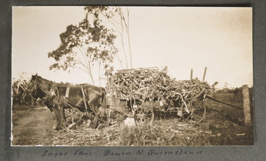 Mission to Seafarers Victoria
Photograph - Photograph, Sepia, Sugar Cane Bowen North Queensland, Early 20th Century
Bowen is a town in North Queensland, near the Whitsundays. The photograph taken in 1928 is an early image of sugar cane being harvested.One of a series of photographs from an album page where all photographs detached but with descriptive inscriptions. This image was matched to one of these.Small sepia photograph depicting depicting side on view of black horse hitched to a cart loaded with vegetation and one person wearing a hat loading up. sugar cane, horses, queensland, fan album, bowen -
 National Wool Museum
Artwork, Sydney Wool Exchange, 1851, 1851
Image depicting the Sydney Wool Exchange. The donor's father (Wilhelm Eckles) had this picture on his office wall over his 43 year career in the wool industry. The image was possibly won at an event such as a Wool Ball but exact details have been forgotten.Artwork drawn on paper with wood and gold frame. Artwork depicts the Sydney Wool Exchange in the Background with trees on either side in the foreground and low vegetation bellow.Signed, bottom right corner: John Van Vliet Rear, lettering: This Picture Belongs to W.M. Eckels 17 Bushlands Ave Gordonsydney wool exchange -
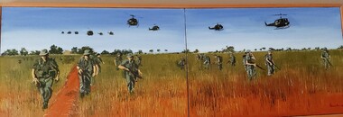 Diamond Valley Vietnam Veterans Sub-Branch
Painting - On Patrol, n/a, c2002
Painting depicts a typical patrol by Australian soldiers, this time in open grasslands.Item is a realistically accurate picture of Australian Soldiers in the field.Original painting, in two pieces depicting Australian soldiers on patrol; also give an insight as to vegetation common within patrol areas at this particular place and time.Signature of painter.vietnam, vietnam war, diamond valley vietnam veterans sub branch -
 Lakes Entrance Historical Society
Photograph - Orme, 1906 c
Also small format sepia toned photograph of the 'Orme' without sail, anchored on lakeBlack and white photograph showing the fishing boat Orme in full sail on lake, eight people on board. Some vegetation in foreground. Lakes Entrance Victoriaboats and boating, fishing industry -
 Lakes Entrance Historical Society
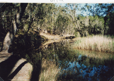
Photograph - Mississippi Creek Landing, Fish Marie, 1997
Date made 18 January 1997Color photograph of Mississippi Creek at the head of the North Arm. It shows natural vegetation on the banks of the creek, which is reflected in the calm waters. Lakes Entrance Victoria waterways, transport -
 Lakes Entrance Historical Society
Photograph - Southern Cross Star, 1980
Colour photograph of the scallop fishing boat Southern Cross Star in Cunninghame Arm, three people on deck, vegetation on hummocks in background. Lakes Entrance Victoriaboats and boating, fishing industry -
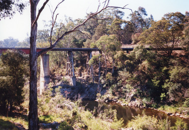 Lakes Entrance Historical Society
Photograph - Bridges, 1998
Re Heritage StudyColour photograph of the railway bridge over Boggy Creek, showing the bridge high above the waterway, rocky terrain and scrubby vegetation. Nowa Nowa, Victoria,bridges, waterways, transport -
 University of Melbourne, Burnley Campus Archives
Plan, Merri Creek Management Committee Base Map, c. 1990
(1) 2 sets Base Maps Scale 1:5000 MCMC. (2.) 2 sets Merri Creek remnant vegetation Scale 1:5000.merri creek, management plan, northcote, coburg, reservoir, fawkner, thornbury, remnant vegetation -
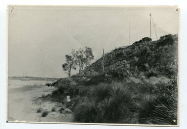
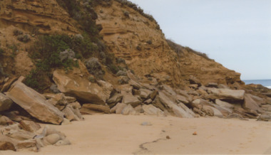 Lakes Entrance Historical Society
Photograph - Red Bluff 2008, Wendy Price, 1/08/2008 12:00:00 AM
This is the after photograph used in the 150 years Lakes Entrance 1858 to 2008 display held in October 2008 paired with image 03731 for displayColour photograph of west side of Red Bluff showing vegetation on the bluff rock and sand at the base situated on ninety mile beach Lake Tyers Victoria waterways, topography -
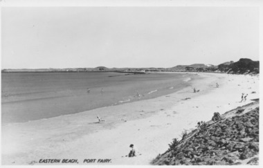 Port Fairy Historical Society Museum and Archives
Photograph, Valentine Publishing Co, Eastern Beach Port Fairy
Early view looking towards Griffiths Island showing the dunes with vegetation on themReflects change in coast over timeBlack and white photograph of curve of East BeachEastern Beach Port Fairy 16beach, sea, seascape, east beach -
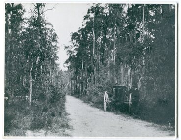 Orbost & District Historical Society
black and white photograph, 1913
This photograph shows the regrowth of vegetation on the road between Genoa and the border - now the Princes Highway.This is a pictorial record of the main road from Orbost to the New South border, The Princes Highway, in the early 20th century.A large black / white photograph of a bush road wwith a vehicle and a man on the side of it.on back - " Princes Highway showing the regrowth.....1913"princes-highway-genoa transport -
Ballarat Heritage Services
Book, Hepburn Shire Council Biodiversity strategy, 2018, 2018
48 Page report on biodiversity in the Victorian Shire of Hepburn. non-fictionbiodiversity, shire of hepburn, ricky nelson, dja dja wurrung, public land management, climate change, habitat corridors, biolink zones, weed management -
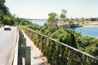 Lakes Entrance Historical Society
Photograph - Princes Highway Lakes Entrance, 1990 c
One other photograph showing vegetation taken from the left hand side of road.Colour photograph taken from the Princes Highway, showing the last bend in the road before the northern approach to the concrete North Arm Bridge, shows the North Arm and waterfront in distance. Lakes Entrance Victoria bridges, roads and streets, township -
 Orbost & District Historical Society
black and white photograph, C1890
Marlo was once a very busy port. Goods needed by the early settlers were carted by sea-going vessels to Marlo. At the Marlo wharf goods were unloaded from the large vessels onto barges and towed by paddle steamers to Orbost. (information - In Times Gone By - Deborah Hall)This item is a pictorial record of Marlo in the late 19th century.A black / white photograph of a beach with a sloping hillside covered in thick vegetation. There is a pole at the top with a light on it. It overlooks the jetty. A sailing ship can be seen in the background - left.on back - "Marlo showing light on pole on the point above the jetty about 1890"marlo-19th-century marlo-jetty -
4th/19th Prince of Wales's Light Horse Regiment Unit History Room
Booklet, Sands & McDougall Pty Ltd, Tropical Warfare (Aust), 1945
Soft covered booklet providing junior commanders with practical methods of fighting the Japanese in the tropics - covering subjects such as vegetation, hygiene & sanitation, tactics and jungle craft etcPamphlet No 2 1945world war 2, jungle training, japanese -
Bendigo Historical Society Inc.
Photograph - VICTORIA HILL - GEORGE LANSELL'S BIG BLUE HEAP
Coloured photo of George Lansell's big Blue Heap, off Sullivan's Street. Photo shows sand heap with two peppercorn trees and vegetation beside a road.photo, victoria hill, george lansell's big blue heap -
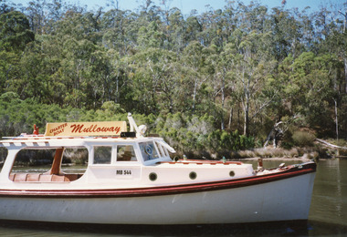 Lakes Entrance Historical Society
Photograph - Mulloway, Holding M, 1997
Date made January 1997Colour photograph showing charter boat Mulloway MB544, owned by Antony Heath, taken in North Arm. Thick vegetation on far bank. Lakes Entrance Victoriawaterways, boats and boating, tourism -
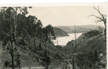 Lakes Entrance Historical Society
Postcard - North Arm, Valentine Series, 1920c
No. 1 from Valentine Series of small postcardsBlack and white postcard showing lower reach of North Arm, and gully. Vegetation has been removed from both sides of gully. Lakes Entrance VictoriaNorth Arm Lakes Entrance topography, waterways