Showing 127 items matching "bay view house"
-
 Mt Dandenong & District Historical Society Inc.
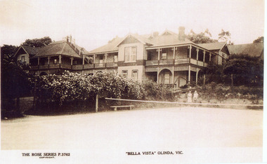
Photograph, "Bella Vista" Olinda, c1940
Copy of Rose Series Postcard number 3762Copy of Rose Series Postcard #3762 showing Bella Vista Guest House at Olinda. This image is c1940s and shows the tennis court in the foreground. Bella Vista was built by Edmund Boulter in 1903. It comprised two large buildings with a walkway linking the balconies at second storey level. Views of Westernport and Port Phillip Bays could be seen from the rooftop lookout. Bella Vista was reputed to accommodate eighty guests. The Guest House operated until 1956, when it burned down.bella vista, guest house, tennis, boulter, rose series -
 Bayside Gallery - Bayside City Council Art & Heritage Collection
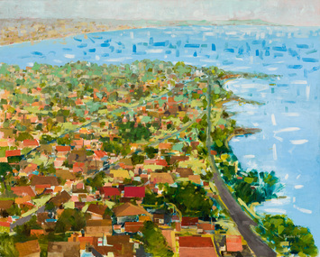
Painting - oil on canvas, John Trebilco, Aerial view of Black Rock, 1978
boats, bay, water, half moon bay, black rock, bayside, john trebilco, aerial, houses, streets, coast, beaumaris, beach road -
 Bendigo Historical Society Inc.
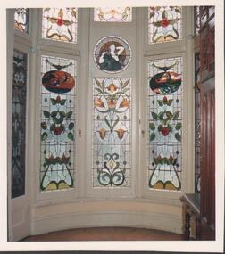
Photograph - FORTUNA COLLECTION - PHOTOGRAPH
Colour photograph of stained windows (interior view) in a bay window setting. Two stained windows to the left and right are the same design, a smaller stained window of a different design is in the centre of them and a small round stained window with a woman (waist view up) above. Partial views of other windows. -
 Bendigo Historical Society Inc.
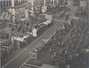
Photograph - BENDIGO ORDINANCE FACTORY COLLECTION: ASSEMBLY BAY OF NO 9 SHOP, 1950s
Overhead view of full construction action of Assembly Bay within No 9 shop at the Bendigo Ordinance factory B&W photo taken in 1950s -
 Kew Historical Society Inc
Photograph, J F C Farquhar, A View in Studley Park Road, 1891
At the beginning of the 1890s, the Kew businessman and Town Councillor, Henry Kellett, commissioned J.F.C. Farquhar to photograph scenes of Kew. These scenes included panoramas as well as pastoral scenes. The resulting set of twelve photographs was assembled in an album, Kew Where We Live, from which customers could select images for purchase.The preamble to the album describes that the photographs used the ‘argentic bromide’ process, now more commonly known as the gelatine silver process. This form of dry plate photography allowed for the negatives to be kept for weeks before processing, hence its value in landscape photography. The resulting images were considered to be finely grained and everlasting. Evidence of the success of Henry Kellett’s venture can be seen today, in that some of the photographs are held in national collections.It is believed that the Kew Historical Society’s copy of the Kellett album is unique and that the photographs in the book were the first copies taken from the original plates. It is the first and most important series of images produced about Kew. The individual images have proved essential in identifying buildings and places of heritage value in the district.This is the earliest known photograph of the exterior of Byram (later Tara Hall). It shows the original red brick fence, its asymmetrical gate and gateposts, with a large terra cotta gargoyle surmounting the higher of the two. The architect, Edward Kilburn designed Byram in the Arts & Crafts style for the industrialist George Ramsden. Construction began in 1888 and was reputed to have lasted three years. The mansion had frontages to Studley Park Road and Stevenson Street, including gardens laid out with great taste, including pleasure grounds, tennis lawn, fruit and flower garden, and paddock. The size of many of the trees in the garden indicate that many survived from the garden of Clifton Villa, the previous single-storeyed house built on the site by the Stevenson brothers. Byram had views to Melbourne and Port Phillip Bay. The house was demolished in 1960, despite opposition from the National Trust (Victoria), and its gardens subdivided into residential allotments.A View in Studley Park Roadkew illustrated, kew where we live, photographic books, henry kellett, byram, tara hall, goathlands -
 Kew Historical Society Inc
Photograph - 'Clutha', Studley Park Road, 1860-1890
Clutha was the home of John Carson, the second mayor of Kew. Leonard Terry designed the house for him in 1856. Terry was the architect of the Melbourne Club (1858), the former London Chartered Bank (1861), Lothian Terrace in Carlton (1865), and the ES&A Bank in Hawthorn (1873). The commission for Clutha was won three years after Terry’s arrival in Victoria.An extremely rare photograph of a major residential architectural commission of Leonard Terry. The photograph of the house has statewide significance as the home of the Victorian pioneer and businessman, John Carson. A rare, nineteenth century photograph of ‘Clutha’ in Studley Park Road, Kew. The sepia-toned photograph is of the front of the house, with its bluestone foundations and its second storey balcony. A real estate advertisement in 1875 described the house as: 'First-class family mansion, and about 8½ acres of pleasure grounds and fruit garden. The house, erected under the plans and supervision of Mr. Leonard Terry, is most substantially built of brick, stuccoed, on solid bluestone pediment, forming a noble basement story, large entrance hall, and lobby, with conservatory on the left. *** A wide verandah and balcony, erected on cast-iron columns, runs round the house, the views from which are perhaps unequalled in extent and beauty in the neighbourhood of the city, commanding the bay, shipping, Mount Macedon, and Dandenong Ranges. Th e whole forming a most complete gentleman's residence, no expense having been spared in its erection and comfortable finish.'"Clutha West Side Studley Park Road Kew / Clutha West Side"clutha, john carson, leonard terry -
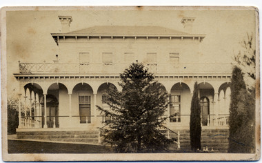
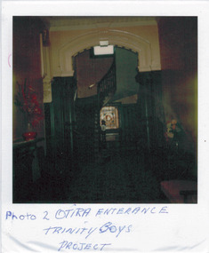 Kew Historical Society Inc
Photograph - 'Otira', 73 Walpole Street, 1978
Sanderson P (1988): '73 Walpole Street (Kew), 'Otira'. Built 1887. Original use - Residence. Architect - Crouch. Henry Berry, a noted philanthropist and salt merchant of Melbourne, was the original owner of this two-storey, boom-period house. Berry occupied the residence until his death in 1923 while in February the following year, the property was auctioned. Subsequently purchased by the Methodist Church for use as a training college for missionaries, a number of additions and alterations were made at that stage including a memorial chapel that was built on the property in 1957.' Otira is now a private residence. Original colour positive photograph (polaroid) of 'Otira', 73 Walpole Street, Kew, taken in 1978 by students in Form 3R at Trinity Grammar School as part of a project. The view in the photograph is of the panelled entrance hall."Photo 2 / Otira entrance / Trinity Bays Project"otira - 73 walpole street, henry berry, historic houses -- kew (vic.), trinity grammar school, melbourne architects -- crouch, interior design -- entrance halls -- 1880s -
 Kew Historical Society Inc
Photograph - 'Mandalay', Molesworth Street (Kew), 1979
Small, square, original colour positive photograph of 'Mandalay', Molesworth Street, Kew, taken in 1979 by Elizabeth Mackie. Side view showing double-storey colonnade faced with cement pilasters on first floor and projecting bay window on both floors.Annotated in ink on reverse: " Mandalay, 3 Molesworth St. / once Morrissey family home / Donated by E Mackie 1979"mandalay, historic houses -- kew (vic.), mansions -- kew (vic.), morrissey family -
![Township of Lorne, and Loutitt Bay / [by] Nicholas Caire, circa 1876](/media/collectors/550653872162f11fb04854aa/items/5783458ad0cdd1176c6f0c78/item-media/578345eed0cdd1176c6f852b/item-fit-380x285.jpg) Kew Historical Society Inc
Kew Historical Society IncPhotograph, Anglo-Australasian Photographic Company, Township of Lorne, and Loutitt Bay, c. 1876
Nicholas Caire was born on Guernsey in the Channel Islands in 1837. He arrived in Adelaide with his parents in about 1860. In 1867, following photographic journeys in Gippsland, he opened a studio in Adelaide. From 1870 to 1876 he lived and worked in Talbot in Central Victoria. In 1876 he purchased T. F. Chuck's studios in the Royal Arcade Melbourne. In 1885, following the introduction of dry plate photography, he began a series of landscape series, which were commercially successful. As a photographer, he travelled extensively through Victoria, photographing places few of his contemporaries had previously seen. He died in 1918. Reference: Jack Cato, 'Caire, Nicholas John (1837–1918)', Australian Dictionary of Biography.An original, rare photograph from the series 'Views of Victoria: General Series' by the photographer, Nicholas Caire (1837-1918). The 60 photographs that comprise the series were issued c. 1876 and reinforced a neo-Romantic view of the Australian landscape to which a growing nationalist movement would respond. Nicholas Caire was active as a photographer in Australia from 1858 until his death in 1918. His vision of the Australian bush and pioneer life had a counterpart in the works of Henry Lawson and other nationalist poets, authors and painters.‘Township of Lorne, and Loutitt Bay’ : Views of Victoria (General Series) No.60 : Albumen silver photograph | Photo on card with Title and Description on reverse | Mounted 24 x 30 cm; Photo 12 x 17 cm.On Reverse: ‘Loutitt Bay is fast becoming one of the most fashionable Watering-places in Victoria, partly from its easy access by Rail, combined with the magnificent scenery to be found in the Cape Otway Ranges, and the very moderate charges of the houses of accommodation. The large house near the foreground is that of Mr. Mountjoy, which is a Restaurant. Duncan’s Hotel can be seen in the distance, on the brow of the hill.’nicholas caire (1837-1918), lorne (vic), duncan's hotel, loutitt bay, landscape photography - victoria -
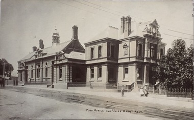 Kew Historical Society Inc
Postcard, Post Office and Police Court Kew, 1907-1915
The Kew Historical Society's postcard collection includes views of Kew, Melbourne and Greater Melbourne as well as those including overseas scenes sent or received from Europe or the Middle East. They date from the 1890s to the 2000s. These postcards may or may not include the name of the publisher or printer. A number of the cards were published as parts of popular series. A way of dating early postcards is to identify whether the reverse was divided by a central line which became the norm after 1902 in the United Kingdom. However, other postcards produced after this date do not always conform to this print layout.The item forms part of the Laurie Bennett collection of thirty-six postcards and photographs of Kew and early Melbourne, donated to the Kew Historical Society in 1980. The postcards in the Bennett collection, like other images in the Society's holdings date from the 1890s to the present and comprehensively indicate points-of-view or scenes considered historically, aesthetically or socially significant in the period in which they were produced.Postcard depicting the Kew Post Office and Court House (built 1888) on the corner of High Street and Cotham Road. In front of the Post Office is a large Moreton Bay Fig tree. The later Kew War Memorial (opened 1925) necessitated the removal of the tree and the relaocation of the Queen Victoria Jubilee Fountain. "No-KH-388. 1888. Donated by Mr. L. Bennett. Later buildings joined. Fig tree + Queen Victoria Jubilee Fountain moved to make way for World War I Memorial 1920."kew court house, kew post office, postcards -
 Kew Historical Society Inc
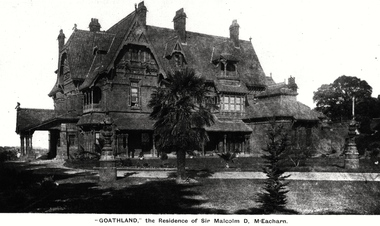
Photograph, 'Goathland', The Residence of Sir Malcolm D McEacharn, 1901-1911
The architect, Edward Kilburn designed Byram in the Arts & Crafts style for the industrialist George Ramsden. Construction began in 1888 and was reputed to have lasted three years. The mansion had frontages to Studley Park Road and Stevenson Street, including gardens laid out with great taste, including pleasure grounds, tennis lawn, fruit and flower garden, and paddock.The size of many of the trees in the garden indicate that many survived from the garden of Clifton Villa, the previous single-storeyed house built on the site by the Stevenson brothers. Byram had views to Melbourne and Port Phillip Bay. The house was demolished in 1960, despite opposition from the National Trust (Victoria), and its gardens subdivided into residential allotments.An early photograph of Goathland (also known as Byram, Lowan and Tara Hall). The photo shows the front of the building during the period of Sir Malcolm McEacharn’s occupation of the house (1901-11). Edward George Kilburn, of Ellerker & Kilburn, had originally designed the house for the industrialist George Ramsden in 1888. When Sir Malcolm McEacharn purchased Byram, he was to rename it as Goathland. This has led to some confusion, as Goathland was also the name used for McEacharn’s other home in St. Kilda. The period of McEacharn’s ownership represented the high point of the mansion’s history. 'Lost Glories: a memorial to forgotten Australian buildings' was published by David Latta in 1986. It tells the story of a number of significant Australian buildings that had previously been demolished. A chapter in the book was devoted to Goathland, later known as Tara Hall. To supplement the text, he sourced photographs from a range of suppliers, chiefly the Royal Women's Hospital which had once owned Tara Hall, but had sold it in 1960. This is one of the photographs donated to KHS by the author."'Goathland', The Residence of Sir Malcolm D McEacharn"byram, goathland, tara hall, lowan, studley park road -- kew (vic.), melbourne mansions, e g kilburn - architect -
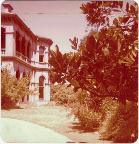
 Kew Historical Society Inc
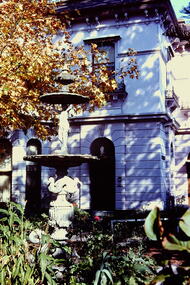
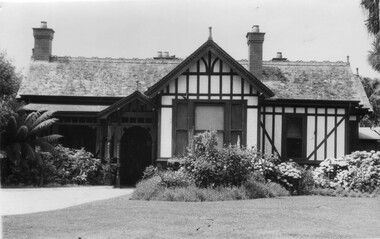
Slide - Derham House (formerly 'Mount View), 8 Selbourne Road, 1979
One of a group of slides taken by members of the Society of built heritage in Kew in 1979-80. The selection of subject matter reflects the priorities of the period. The colour of some slides has degraded.The slides represent a snapshot in time of built architecture in Kew, much of which has changed in the forty-plus period since they were created.Colour positive transparency (slide) of the the fountain and garden of Derham House, formerly 'Mount View', 8 Selbourne Road, Kew. The house wa designed in 1888 by the architect Frederick de Garis as his home. Prue Sanderson, 'Kew Conservation Study: Vol.II" wrote about Mount View that: "The house is typical of the late Victorian period in it being clad in render and styled in the Italianate. It has an asymmetrical composition with polygon bay windows extending up both floors, to each of the main facades. The ground floor is heavily incised with banded rustication, while the first floor is distinguished by the cast iron balconettes to each window. The fountain and pond in the garden appear to be those depicted in the 1903 MMBW plan of the property.""Fountain Ruyton in front of Derham House"historic houses -- kew (vic.), ruyton girls' school, derham house, mount view, italianate architecture, fountains -
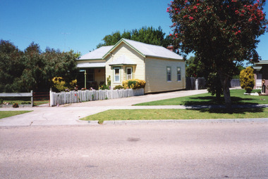
 Surrey Hills Historical Society Collection
Photograph, 5 York Street, Mont Albert, May 1985 (1), 1985
This is the home of Ernest Augustus Young (1891-1985) and Ruby Nichell Whitby (1892-1984) and their son Ernest Lance Young. Lance was born 24 March 1915 in Surrey Hills; after he married Beryl Mair. Electoral roll for 1937 gives the house name as 'Whitby Lodge'. Ernest and Ruby also had twins Clive and James who died in infancy. Buried at Box Hill Cemetery - M-*-0867 (family plot) This is part of a large collection relating to the Mair, Deakin and Young families. REF: Memoir of Laurie Newton (nee Young) - Her grandfather bought the land and had the house built. She remembers it as having pressed ceilings in some rooms and ornate fireplaces and tiles and leadlight windows in some rooms and doors with leadlight panels. Her grandfather was a keen gardener with an ornamental front garden and many vegetables and fruit trees in the back yard. Her grandfather sold the adjoining block (No 3 York Street), which had been used for growing flowers and vegetables, to John and Edna Jean. Reid. She also remembered that he extended the house and divided it into 2 flats, renting out the northern side for 20 years. Sold by Jellis Craig on 24 December 2010 - With formal living, dining, 3 bedrooms, 2 bathrooms, garage/ample OSP. Land: 18.2m x 40.8m (60' x 134') approx. Large 2 storey house replaced the house.Colour photo of the street view of 5 York Street, Mont Albert. The house is Edwardian in style, constructed from weatherboard painted white with a red corrugated iron roof with simple finials. There is a small veranda with simple fretwork, lead-light feature windows to one, possibly two front rooms, one of which has a bay window. There is a garage set back at the side of the house with a concrete driveway on the south side of the house towards Mont Albert Road. The fence is low and constructed from roughly faced stone. The garden contains mature shrubs.In blue biro on rear: "1985 / POP'S" ; "5 YORK ST / E.A. YOUNG". Red photographic processing stamp "PROCESSED BY / KODAK / MAY 85M"ernest augustus young, ruby nichell whitby, ruby nichell young, ernest lance young, box hill cemetery, whitby lodge, house names, mont albert -
 Surrey Hills Historical Society Collection
Photograph, 5 York Street, Mont Albert, November 1999 (1), 1999
This is the home of Ernest Augustus Young (1891-1985) and Ruby Nichell Whitby (1892-1984) and their son Ernest Lance Young. Lance was born 24 March 1915 in Surrey Hills; after he married Beryl Mair. Electoral roll for 1937 gives the house name as 'Whitby Lodge'. Ernest and Ruby also had twins Clive and James who died in infancy. Buried at Box Hill Cemetery - M-*-0867 (family plot) This is part of a large collection relating to the Mair, Deakin and Young families. REF: Memoir of Laurie Newton (nee Young) - Her grandfather bought the land and had the house built. She remembers it as having pressed ceilings in some rooms and ornate fireplaces and tiles and leadlight windows in some rooms and doors with leadlight panels. Her grandfather was a keen gardener with an ornamental front garden and many vegetables and fruit trees in the back yard. Her grandfather sold the adjoining block (No 3 York Street), which had been used for growing flowers and vegetables, to John and Edna Jean. Reid. She also remembered that he extended the house and divided it into 2 flats, renting out the northern side for 20 years. Sold by Jellis Craig on 24 December 2010 - With formal living, dining, 3 bedrooms, 2 bathrooms, garage/ample OSP. Land: 18.2m x 40.8m (60' x 134') approx. Large 2 storey house replaced the house. Adjacent house (No 7 York Street) has been renovated. This is part of a large collection relating to the Mair, Deakin and Young families. Colour photo of the street view of 5 York Street, Mont Albert. Taken from the verge, it is a good view of the front of the house. The house is weatherboard with a red corrugated iron roof with simple finials. It is Edwardian in style with simple chimneys in brick and stucco. There is a small veranda with simple fretwork on the southern corner of the house and a bay window to one of the front rooms. There are striped canvas blinds, which are down, on the windows of the 2 front rooms, above which are small lead light windows. The house is partly screened by a mature shrubs. The garden is set behind a fence low fence and constructed from dressed stone. In black permanent marker on rear: "5 YORK ST / NOV. 1999" ernest augustus young, ruby nichell whitby, ruby nichell young, ernest lance young, box hill cemetery, whitby lodge, house names, mont albert -
 Surrey Hills Historical Society Collection
Photograph, 5 York Street, Mont Albert, November 1999 (2), 1999
This is the home of Ernest Augustus Young (1891-1985) and Ruby Nichell Whitby (1892-1984) and their son Ernest Lance Young. Lance was born 24 March 1915 in Surrey Hills; after he married Beryl Mair. Electoral roll for 1937 gives the house name as 'Whitby Lodge'. Ernest and Ruby also had twins Clive and James who died in infancy. Buried at Box Hill Cemetery - M-*-0867 (family plot) This is part of a large collection relating to the Mair, Deakin and Young families. REF: Memoir of Laurie Newton (nee Young) - Her grandfather bought the land and had the house built. She remembers it as having pressed ceilings in some rooms and ornate fireplaces and tiles and leadlight windows in some rooms and doors with leadlight panels. Her grandfather was a keen gardener with an ornamental front garden and many vegetables and fruit trees in the back yard. Her grandfather sold the adjoining block (No 3 York Street), which had been used for growing flowers and vegetables, to John and Edna Jean. Reid. She also remembered that he extended the house and divided it into 2 flats, renting out the northern side for 20 years. Sold by Jellis Craig on 24 December 2010 - With formal living, dining, 3 bedrooms, 2 bathrooms, garage/ample OSP. Land: 18.2m x 40.8m (60' x 134') approx. Large 2 storey house replaced the house. Adjacent house (No 7 York Street) has been renovated. This is part of a large collection relating to the Mair, Deakin and Young families. Colour photo of the street view of 5 York Street, Mont Albert. Taken from the rear of the house verge, it is a good view of the front of the house. The house is weatherboard with a red corrugated iron roof with simple finials. It is Edwardian in style with simple chimneys in brick and stucco. There is a small veranda with simple fretwork on the southern corner of the house and a bay window to one of the front rooms. There are striped canvas blinds, which are down, on the windows of the 2 front rooms, above which are small lead light windows. The house is partly screened by a mature shrubs. The garden is set behind a fence low fence and constructed from dressed stone. In black permanent marker on rear: "5 YORK ST / NOV. 1999" ernest augustus young, ruby nichell whitby, ruby nichell young, ernest lance young, box hill cemetery, whitby lodge, house names, mont albert -
 Surrey Hills Historical Society Collection
Photograph, 10 Pembroke Street, Surrey Hills
‘Eignbrook’ at 10 Pembroke Street was built 1904. Until the 1950s this area was the highest spot in the metropolitan area and ships in the Bay could be seen from ground level and views extended almost 360 degrees. A number of homes of this Edwardian period had viewing towers, the one in the photo being that of ‘Maroondah’ at 12 Pembroke Street. Photo taken by W V Hill. Courtesy: Mr William (Bill) Dempsey. Original sepia photograph of a weatherboard home in the Queen Anne style. It has a steep pitched iron roof. It has a woven wire fence across the front of the property and decorative gates. Mounted on white cardboard photo taped on 2 corners.Back of photo is inscribed “Hills, 10 Pembroke St, Surrey Hills”. Card has written underneath the photo, “10 Pembroke St, Home of Hills family, built 1904”pembroke street, house names, surrey hills, hills family, 'maroondah', 'eignbrook', (mr) w v hill, (mr) william (bill) dempsey, journalist, queen anne style, (mrs) annie hill -
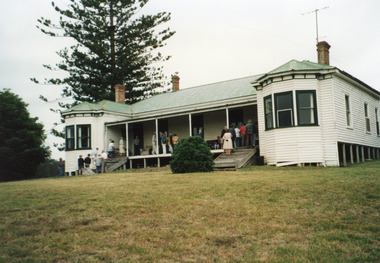
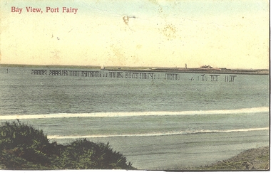 Port Fairy Historical Society Museum and Archives
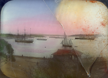
Photograph - Postcard, Bay view
... east beach light house keepers house pier Bay View Hand ...Hand coloured Photograph/postcard of East beach showing ruins of the pier and in the background the lighthouse keeper's residenceBay Viewbeach, sea, seascape, postcard, east beach, light house keepers house, pier -
 Port Fairy Historical Society Museum and Archives
Photograph
This view of the Customs house and Court house also includes the wreck bell which hung on a plinth outside the Customs house until the 1970's. The wreck bell was rung to alert the town that a ship was in trouble in the bayBlack and white photograph of the Wreck bell at Courthouse & Customhousebuilding, home, house, government, gipps street, court house, customs house, wreck bell -
 City of Kingston
Photograph - Colour, 1998
The name Mordialloc was derived from the name Moody Yallock, which comes from the Bunurong language. The Bunurong Peoples are the Traditional Owners of this area. The name means “high water” or “high creek”. In 1839, colonial authorities declared the mouth of the creek, and an additional 830 odd acres as an Aboriginal Reserve, although this proclamation was never gazetted. The reserved land included part of the Carrum Carrum Swamp which was abundant with wild life and natural resources. Regular encroachments, including land sales which began in 1863, were made on the land until 1878 when the Reserve was declared closed, and the land was opened up to land sales. Market gardening and suburban house lots quickly began to develop, and Mordialloc became a renowned picnic and holiday site. Mordialloc Creek is a popular bay side destination for local and visitors, and is a site for boating, kayaking, fishing and swimming, along with many other activities.Colour photograph of Mordialloc Creek, looking inland.Small fishing and leisure boats are moored on either side of creek, with a view of the Mordialloc Bridge Hotel in the background.mordialloc, bunurong, traditional owners, suburbs, boats, fishing, waterways, hotel -
 City of Kingston
Photograph - Black and white, c. 1970
The Highett Gas Works were a landmark along the Nepean Highway for many years. With the cessation of the gasification of coal and the introduction of natural gas to Victoria, the gas holders were demolished and the Sir William Fry Reserve was developed on the southern end of the site. The Gas and Fuel redeveloped the northern end of the site with modern offices and laboratories for the organisation's scientific services. At this time, the chimney and retort house were retained.The Highett Gasworks had its beginning in 1939 operated by the Central Brighton and Moorabbin Gas Co Ltd. The company had expanded its gas production facilities to Highett where it had purchased 45 acres of land adjacent to the Melbourne-Frankston railway line. The first gasholder was erected on the Highett site in 1927 and connected with high pressure mains to the Brighton Gas Works. In 1939 the building program including gasometers, the vertical retort house and coal store was completed and gas making commenced. Its area of supply covered approximately 70 square miles and included the municipalities of Brighton, Sandringham, Moorabbin, Mordialloc, Chelsea and part of Dandenong. The Gas and Fuel Corporation eventually took over operations and with the disaggregation and privatisation of the organisation, the site was eventually closed c. 2002.Black and white aerial photograph featuring the Highett Gas Works with gasholders and retort house. In the top right-hand corner, a former Highett Primary School on Graham Road can be viewed. Photograph includes Bay Road, Royal Avenue, Princess Avenue and Jackson Road (Highett) and Alfred, Turner and Sandford Streets (Moorabbin).Handwritten in black ink: [indecipherable] in a circle Handwritten in red ink: 70% Four velcro display adhesivesgasification of coal, gas and fuel corporation of victoria, gasholders, highett, moorabbin, utilities -
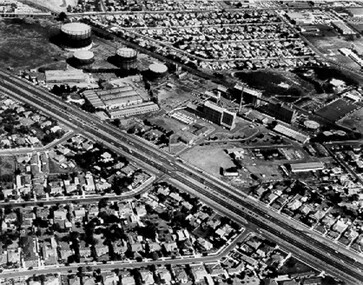
 Port Melbourne Historical & Preservation Society
Photograph - Photocopy, Aerial view, Swallow & Ariell to infilled Lagoon, 1946
Donor was researching property on the corner of Stokes and Graham St, as old timers claim it was "the Nelson Hotel" although there is no record of such in licensing records. Particular building is at upper left of this image.Large photocopy of an aerial photo. 1946 view from Swallow & Ariell to the infilled lagoon and HMAS Barracks. Poor quality image but shows St Joseph's Catholic Church; Holy Trinity; Edwards Park; Lady Forster Kindergarten; Methodist Church on Graham St (no longer there), Bay St. ; three storey Derham houses built environment - industrial, industry - food, swallow & ariell ltd, religion - anglican (holy trinity), religion - wesleyan methodist church, religion - roman catholic church (st josephs), nelson hotel, frederick thomas derham, built environment - domestic, business and traders - hotels -
 Lakes Entrance Historical Society
Photograph - Historic House, 1999
Built 1900c, cottage was made available for widow and children of Dougal Egan, lost when fishing boat Orme disappeared in 1909. After Mrs Egan married George South, cottage became known as the South House. Later resident Mrs Edith Rawlinson. Cottage restumped, refurbished 2011 / 2012.|Also Two colour photographs various viewsColour photograph of a timber cottage at 26 Church Street, with both hipped and gable iron roof. Triple sided bay window. Sash windows on west side, with window hoods. Western wall is on boundary of allotment. Lakes Entrance Victoriahouses, heritage study -
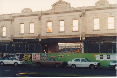 Port Melbourne Historical & Preservation Society
Photograph - Demolition of Market building in Bay St 1989
Market building was established in 1885. Demolition retained the street frontage but new businesses were to come. Colour photo showing demolition of Market Building in By St 1989. Frontage retained. A former passageway through the building enables view of houses in Not St and Council Flatsbuilt environment - civic, built environment - commercial, built environment - demolition -
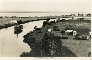 Lakes Entrance Historical Society
Postcard - Eagle Point, 1930 c
Black and white postcard S S Gippsland in Mitchell River, travelling towards Bairnsdale, silt jetties extending eastwards small farm, farm house and sheds on right. Jones bay in Middle distance beyond silt jetty, taken from Eagle Point Bluff. Bairnsdale VictoriaView from Eagle Point. ships and shipping, waterways, agriculture, houses -
 Bendigo Historical Society Inc.
Postcard - Alice McGregor Postcard Collection, 1900 - 1920
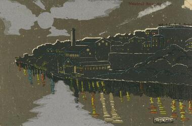
Alice McGREGOR Born: 1908; unknown parents. Possibly adopted by the Salter family? Electoral Roll 1936: Highland Terrace Kangaroo Flat. Alice Mary Salter and William Robert Salter living together; presumed to be sister and brother. William Robert Salter was killed in a MVA in Bendigo in 1937 aged 26. In Victoria in 1938, Alice Mary Salter married James Thomas McGregor (born Victoria 1917, died Victoria 1983, buried Fawkner Cemetery) Lived: 1968; 22 Wade Street Golden Square Alice McGregor Died: 1999 aged 91 at Anne Caudle Centre, Bendigo Buried: Kangaroo Flat Cemetery See additional research. Postcard Album of Alice McGregor contained 86 post cards.Postcard Album of Alice McGregor containing 86 postcards. See 1400 A black, silver and brown picture of Neutral Bay, Sydney at night. Houses and factory on a headland with a 2 masted boat in the water. Reflections on the water. Artist - Redzi NolanAddressee - Miss H.F. Shatford, Black Rock, Sandringham Sender - V.H.Davies, Kanya, 'Mount View Not Dated postcard, collector, alice mcgregor -
 Federation University Historical Collection
Photograph - Lantern Slides, Boxed Lantern Slides, c1920
The lantern slides were most probably used at the Ballarat School of Mines. The image of Rome from St Peter's (Vatican) was taken before 1929. The "Via Conciliazione", built by Mussolini in 1929 is not present in the image. Hinged timber box designed to hold glass lantern slides. The box contains 50 lantern slides including: * male Turk in turbin *interior of a cathedral * Cavalry Scene, Boer War (c1900) * Richard Seddon portrait * Fishermen at Sea * Turkish domed building * Eddystone Lighthouse, England * image of early printing * Cloister Court, Trinity College, Cambridge * Farm Cove, Sydney Harbour (by I.F.E) * National Park, Sydney * Customs House, Sydney * View from the Dome of St Peter's, Rome (Pre 1929) * Botanical Gardens, Sydney * Coogee Bay, NSW * Keeble College Chapel, Oxford * Holy Land - The Village of Endor * Sydney Cove * Interior portrait of members of the Victorian Legislative Assembly, Parliament House, Melbourne * Palace Dela Concord, Italylantern slides, entertainment, ballarat school of mines, boer war, richard seddon, sydney harbour, coogee beach, legislative assembly, rome, roma, vatican, vaticono, fairyland, lake wendouree, glass slide, lantern slide -
 Kew Historical Society Inc
Slide - Villa Alba entrance porch, 1987
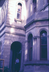
Built for William and Anna-Maria Greenlaw in the early 1880s, and with interiors decorated by the Paterson Bros, Villa Alba remained in private ownership until 1949. From 1950, the house was owned by a number of institutions. By 1984, the Villa Alba Preservation Society had been formed, and three years later, the Mount Royal Hospital granted a 25-year lease to Kew Council. In 2004, the title to Villa Alba was passed by the Victorian Government to The Villa Alba Museum Incorporated. Digital copy of a olour 35mm slide, framed in a plastic mount, of the portico of Villa Alba, 44 Walmer Street, Kew, 3101. The transparency shows the grey rendered tower and entrance, viewed from the east, looking west. The bay window of the drawing room is in the foreground."Villa Alba Exterior 1987"villa alba museum, mount royal hospital, historic houses -- kew (vic.), victorian architecture -- melbourne (vic.) -
 University of Melbourne, Burnley Campus Archives
Photograph - Black and white print, Principal's Residence, 1926-1941
Note by T.H. Kneen 19 November 1991, "this photo is later than B91.5-note replacement of bay windows by picture window in A.W. Jessep's time as Principal."Blsck and white photograph. Front view of house.a.w. jessep, principal, principal's residence, principal's house -
 Lakes Entrance Historical Society
Photograph - Lake Tyers House, 1995
Lake Tyers House built 1886 by R Krokel of Bairnsdale as guest house and stop over being on the coastal road to Orbost and Merimbula. Guest house from 1886 to 1960's.Colour photograph taken at Lake Tyers House, a large timber dwelling built in Victorian Italianate style with two projecting faceted bay windows, corrugated iron roof. Three internal brick chimneys visible through roof. Situated on a prominent headland with a view of Lake Tyers. Lakes Tyers Victoriaaccommodation, guesthouses -
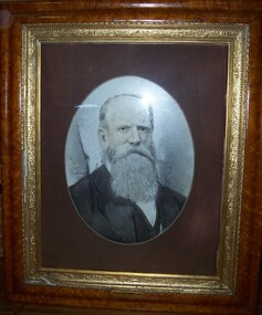 Glenelg Shire Council Cultural Collection
Photograph - Photograph - opalotype, Thomas Must Esq, n.d
Possibly Portland Town Council. Thomas Must, a wealthy Sydney merchant arrived in Portland in 1845. In 1855 prospect was built for Must to a design by local architect George Mathewson. The two storey home was built in expansive grounds with sweeping views of Portland Bay and the township. The stuccoed house is of Regency/Italianate style with a single storey verandah and single storey kitchen wing. In 1878 the original posted verandah was replaced by new verandah and a conservatory to a design of architect Daniel Nicholson. Nicholson had also been responsible for the design of the Assembly Rooms at the London Inn. Thomas Must was active in the Portland Community. He was a Trustee of the Port Philip Savings Bank, a Justice of the Peace, Treasurer of St. Peters Church at Bridgewater and the first Chairman of the Portland Borough Council. Prospect was Thomas Must’s home until his death in 1905. The building has been considerably altered over the years and much of the original Italianate character has been lost. Subsequent owners include B. Cunningham, G.S. Beresford (who changed the property’s name to Waterford), and long-term Liberal Senator Sir Magnus Cormack. Cormack was President of the Senate from 1971 to 1974. In 1976 the Prospect became an aged accommodation centre.Wooden Frame - light brown. Gold inner frame. Fawn mount. Man with long white beard and hair facing right wearing dark jacket. Front: (no inscriptions) Back: (no inscriptions)photography, opalotype, thomas must