Showing 2121 items
matching bendigo maps
-
 Bendigo Historical Society Inc.
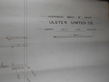
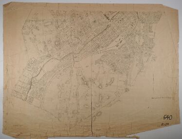
Administrative record - Ulster United Co
... United Co. Garden Gully Line Bendigo Map. Forms part...Bendigo Margaret Roberts gold Map Mine Ulster United Co ...Draftsman's drawing Underground Survey of Mines Ulster United Co. Garden Gully Line Bendigo Map. Forms part of the Margaret Roberts Collection of mining records.bendigo, margaret roberts, gold, map, mine, ulster united co -
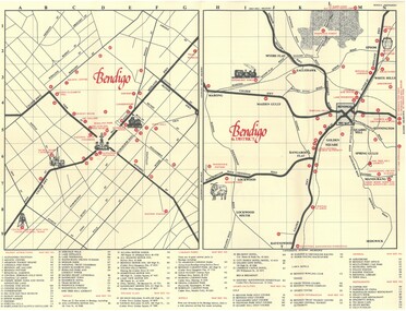
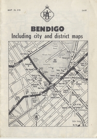 Ballarat Tramway Museum
Map, Royal Automobile Club of Victoria, "Bendigo Including city and district maps - RACV", c1968
... Printed street map titled "Bendigo Including city...in ink on the Bendigo Outlet map, has various notes showing... Parade Ballarat Ballarat goldfields Trams tramways Map Bendigo ...Printed street map titled "Bendigo Including city and district maps", published by the RACV, showing the central part of Bendigo on the front cover, Bendigo Outlets and notes on the city itself. Has the tram lines shown dotted, only shows the full extent of the Golden Square line. Inside has a district road map. The front cover has the number "0468" in the bottom left hand corner, indicating the publication date.in ink on the Bendigo Outlet map, has various notes showing the location of crossing loops on and off the map and the location of the tram depot itself.trams, tramways, map, bendigo, racv, railways -
 Bendigo Historical Society Inc.
Document - TED BEATIE COLLECTION: MAP, Pre 1980s
... Bendigo tourist map and information guide - printed... Bendigo tourist map and information guide - printed by the Bendigo ...Bendigo tourist map and information guide - printed by the Bendigo and District tourist Association -
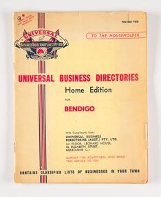 City of Greater Bendigo - Civic Collection
Book, Universal Business Directories, Universal Business Directory for Bendigo, c 1950
... a history of Bendigo, map and recipes as well as extensive listings... the directories. This directory includes a history of Bendigo, map ...Business Directories such as this were common right up until the widespread use of the internet and search engines such as Google to find information. Universal Business Directories were a company which sought advertisers from local areas to offset the cost of producing the directories. This directory includes a history of Bendigo, map and recipes as well as extensive listings for local business, trades and services. 50 page, three colour commercially printed business directory designed to by hung beside the telephone. Includes advertising and listings for a wide variety of local businesses. Includes a page of recipes and information for emergency services. city of bendigo, city of bendigo commerce -
 Bendigo Historical Society Inc.
Map - BENDIGO SHEET 2, Circa 1900
... Map: Bendigo sheet 2 . Parish plan...MAP Bendigo parish plan Bendigo Map: Bendigo sheet 2 ...Map: Bendigo sheet 2 . Parish planmap, bendigo, parish plan, bendigo -
 Bendigo Historical Society Inc.
Map - BENDIGO GOLDFIELD, No date visible
... Map: Bendigo Goldfield. Scale 20 chains to 1 inch. Printed... Inc. History House 11 Mackenzie Street Bendigo goldfields MAP ...Map: Bendigo Goldfield. Scale 20 chains to 1 inch. Printed by Cambridge Press, Bendigo. (number 318 in map cupboard 1)map, bendigo, mining plan, bendigo goldfield, gold mines, mining -
Bendigo Historical Society Inc.
Map - BENDIGO GOLD FIELDS
... Map, Bendigo Gold Fields, copy, mining leases, the numbers... BENDIGO Mining mining leases Map, Bendigo Gold Fields, copy ...Map, Bendigo Gold Fields, copy, mining leases, the numbers of their leases, as well as streets of Bendigo.( number 408 in Map Cupboard 1).bendigo, mining, mining leases -
 Bendigo Historical Society Inc.
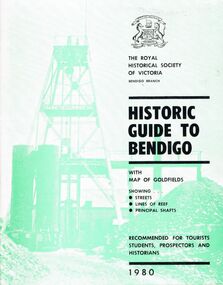
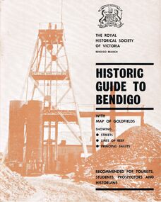
Book - HISTORIC GUIDE TO BENDIGO
... Bendigo Branch, Historic Guide to Bendigo with map(Loose... Bendigo Branch, Historic Guide to Bendigo with map(Loose ...A book titled ' The Royal Historical Society of Victoria Bendigo Branch, Historic Guide to Bendigo with map(Loose), of goldfields showing streets, lines of reef, principal shafts. Recommended for tourists, students, prospectors and historians. 1980.' Cambridge Press, Bendigo. Eighth Edition. Maps, photos, illustrations.bendigo, history, gold mining, book, books, bendigo history, history, victoria, victorian history, australian history, gold, gold fields, gold discoveries, place, the royal historical society of victoria bendigo branch -
 Bendigo Historical Society Inc.
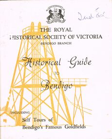
Book - HISTORICAL GUIDE TO BENDIGO
... of Bendigo's Famous Goldfields' .Cambridge Press, Bendigo.' maps... of Bendigo's Famous Goldfields' .Cambridge Press, Bendigo.' maps ...Five copies of ' The Royal Historical Society of Victoria Bendigo Branch Historical Guide to Bendigo. Including Self Tours of Bendigo's Famous Goldfields' .Cambridge Press, Bendigo.' maps, photos, illustrations. Three copies do not contain maps, however, these three copies have number stickers on the bott left front ccover, 0064.2 PAR, 0064.3 PAR, 0064.4 PAR.bendigo, history, gold mining, book, books, bendigo, bendigo history, history, gold mining, mines, the royal historical society of victoria bendigo branch, victoria, goldfields, victorian history, australian history -
 Bendigo Historical Society Inc.
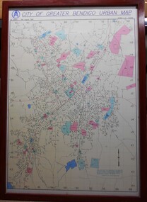
Map - City of Greater Bendigo Urban Map 1996
... City of Greater Bendigo Urban Map 1996...A large framed colour map showing the urban area of Bendigo...A large framed colour map showing the urban area of Bendigo ...A large framed colour map showing the urban area of Bendigo. The map dates to 19 August 1996. It is the first edition and has the scale 1:12500 -
 Bendigo Historical Society Inc.
Book - HISTORIC GUIDE TO BENDIGO
... Bendigo Branch Historic Guide to Bendigo with map of goldfields... Bendigo Branch Historic Guide to Bendigo with map of goldfields ...Five copies of ' The Royal Historical Society of Victoria Bendigo Branch Historic Guide to Bendigo with map of goldfields showing streets, lines of reef, principal shafts. Recommended for tourists, students, prospectors and historians.' Cambridge Press, Bendigo. Third Edition. Maps, photos, illustratons. Only four copies have maps.bendigo, history, gold mining, book, books, bendigo, bendigo history, history, victorian history, victoria, australian history, gold fields, gold, gold discoveries, the royal historical society of victoria -
Bendigo Historical Society Inc.
Map - BENDIGO SHEET 5, May 1949
... Map: Bendigo sheet 5 . Parish plan ( number 209 in Map... Inc. History House 11 Mackenzie Street Bendigo goldfields MAP ...Map: Bendigo sheet 5 . Parish plan ( number 209 in Map Cupboard 1)map, bendigo, parish plan, bendigo -
Bendigo Historical Society Inc.
Map - BENDIGO SHEET 7, May 1949
... Map: Bendigo sheet 7. Parish plan. ( number 208 in Map... Inc. History House 11 Mackenzie Street Bendigo goldfields MAP ...Map: Bendigo sheet 7. Parish plan. ( number 208 in Map Cupboard 1)map, bendigo, parish plan, bendigo -
Bendigo Historical Society Inc.
Map - BENDIGO SHEET 7, 1949 ?
... Map: Bendigo sheet 7. Parish plan ( number 207 in Map... Inc. History House 11 Mackenzie Street Bendigo goldfields MAP ...Map: Bendigo sheet 7. Parish plan ( number 207 in Map Cupboard 1)map, bendigo, parish plan, bendigo sheet 7 -
Bendigo Historical Society Inc.
Map - BENDIGO SHEET 4, Circa 1940's
... Map: Bendigo sheet 4. Parish plan ( number 210 in Map... Inc. History House 11 Mackenzie Street Bendigo goldfields MAP ...Map: Bendigo sheet 4. Parish plan ( number 210 in Map Cupboard 1)map, bendigo, parish plan, bendigo -
 Bendigo Historical Society Inc.
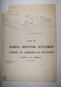
Map - BENDIGO IRRIGATION SETTLEMENT, 20/10/1908
... Map: Bendigo Irrigation Settlement, Parishes of Sandhurst...MAP Bendigo irrigation settlement Bendigo irrigation ...Map: Bendigo Irrigation Settlement, Parishes of Sandhurst and Wellsford, County of Bendigo, Parish planmap, bendigo, irrigation settlement, bendigo irrigation settlement -
 Bendigo Historical Society Inc.
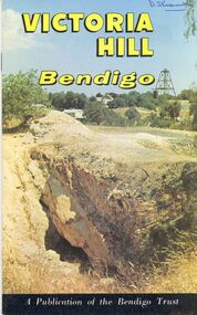
Book - STRAUCH COLLECTION: VICTORIA HILL BENDIGO
... Victoria Hill Bendigo a publication of the Bendigo Trust...BHS Collection BENDIGO Gold mining victoria hill Bendigo ...BHS CollectionVictoria Hill Bendigo a publication of the Bendigo Trust with maps, black and white & colour photographs.bendigo, gold mining, victoria hill, bendigo-history-mining -
 Bendigo Historical Society Inc.
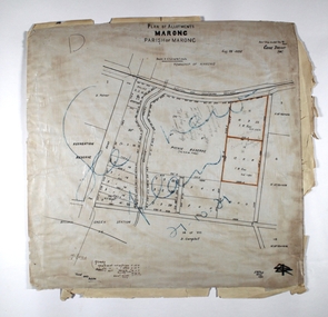
Map - MARONG ALLOTMENTS, 25/08/1906
... of Bendigo. Hand draughted map...MAP Bendigo parish plan Marong Parish of Marong Map: Plan ...Map: Plan of Allotments at Marong, Parish of Marong, County of Bendigo. Hand draughted mapmap, bendigo, parish plan, marong, parish of marong -
 Bendigo Historical Society Inc.
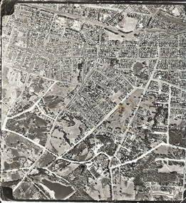
Photograph - AERIAL SURVEY BENDIGO BASE MAP - RUN 12
... AERIAL SURVEY BENDIGO BASE MAP - RUN 12... Bendigo base map - run 12. Inscriptions: Vic 1583. State Aerial... is an aerial survey Bendigo base map - run 12. Inscriptions: Vic 1583 ...Black and white photograph which is an aerial survey Bendigo base map - run 12. Inscriptions: Vic 1583. State Aerial Survey Bendigo Base Map Project - Run 12. 16/3/1967, 5600ASL on front. The photograph shows areas of Kennington and Flora Hill. Title of map to be held at right hand side. Streets identifiable from 'Five Ways' intersection.place, aerial view of bendigo -
 Bendigo Historical Society Inc.
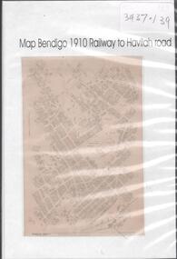
Map - MAP BENDIGO, 1910
... MAP BENDIGO...DVD. Map of Bendigo 1910 Railway to Havilah Road....DVD. Map of Bendigo 1910 Railway to Havilah Road. Map MAP ...DVD. Map of Bendigo 1910 Railway to Havilah Road. -
 Bendigo Historical Society Inc.
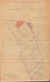
Map - MCCOLL, RANKIN AND STANISTREET COLLECTION: MAP LEASE NO 10423
... . Stanfield, mining district of Bendigo. Map shows lease coloured..., mining district of Bendigo. Map shows lease coloured in red, see ...Buff coloured map. On top of map 'plan of area applied for on lease no. 10423, under the mining leases regulations, by John G. Stanfield, mining district of Bendigo. Map shows lease coloured in red, see record 2205.821b for letter pertaining to map. Street on map: Rowan St., Shamrock St., Mackenzie Street, Old High St., High Street, Ophir Street, Booth Street.bendigo, business, mccoll, rankin & stanistreet -
 Bendigo Historical Society Inc.
Map - MARONG, 21/01/1916
... Map: Parish of Marong, County of Bendigo. Parish plan. Map...MAP Bendigo parish plan Marong Map: Parish of Marong ...Map: Parish of Marong, County of Bendigo. Parish plan. Map dated 21/01/1916map, bendigo, parish plan, marong -
 Bendigo Historical Society Inc.
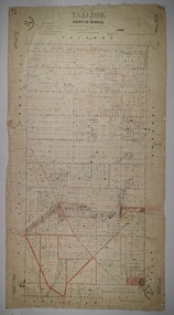
Map - YALLOOK, 25/02/1876
... Map: Parish of Yallook, County of Bendigo. Parish plan. Map...MAP Bendigo parish plan Yallook Map: Parish of Yallook ...Map: Parish of Yallook, County of Bendigo. Parish plan. Map dated 25/02/1876.map, bendigo, parish plan, yallook -
 Bendigo Historical Society Inc.
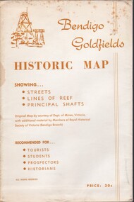
Document - BENDIGO GOLFIELDS HISTORIC MAP
... BENDIGO GOLFIELDS HISTORIC MAP...Bendigo goldfields historic map showing streets, lines... PLACE Bendigo map Bendigo goldfields historic map showing ...Bendigo goldfields historic map showing streets, lines of reef, principal shafts. Original map (dept of Mines) with additional material by members of RHSV (Bendigo Branch) . Price 30c. Map; is folded into envelope for sale and storage.place, bendigo, map -
 Bendigo Historical Society Inc.
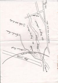
Document - CONSTABLE RYAN COLLECTION: SKETCH MAP OF BENDIGO CREEK
... CONSTABLE RYAN COLLECTION: SKETCH MAP OF BENDIGO CREEK...Sketch map of Bendigo creek, Chinese camp and White Hills... Inc. History House 11 Mackenzie Street Bendigo goldfields MAP ...Sketch map of Bendigo creek, Chinese camp and White Hills cemetery.map, bendigo, white hills -
 Bendigo Historical Society Inc.
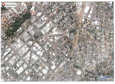
Map - BENDIGO MAP AERIAL VIEW
... BENDIGO MAP AERIAL VIEW...Map of Bendigo. Aerial View of Bendigo. Published by City... PHOTOGRAPH Aerial bendigo Map of Bendigo. Aerial View of Bendigo ...Map of Bendigo. Aerial View of Bendigo. Published by City of Bendigo. Undated.photograph, aerial, bendigo -
Bendigo Historical Society Inc.
Map - BENDIGO WEST IRRIGATION SETTLEMENT, 27/07/1910
... Map: bendigo West Irrigation Settlement, Parish... Inc. History House 11 Mackenzie Street Bendigo goldfields MAP ...Map: bendigo West Irrigation Settlement, Parish of Sandhurst, County of Bendigo. Parish plan ( number 193 in Map Cupboard 1)map, bendigo, irrigation settlement, bendigo west irrigation settlement -
Bendigo Historical Society Inc.
Map - BENDIGO WEST IRRIGATION SETTLEMENT, 13/02/1909
... Map: Bendigo West Irrigation Settlement, Parish... Inc. History House 11 Mackenzie Street Bendigo goldfields MAP ...Map: Bendigo West Irrigation Settlement, Parish of Sandhurst, County of Bendigo. Parish plan. ( number 191 in Map Cupboard 1)map, bendigo, irrigation settlement, bendigo west irrigatioon settlement -
Bendigo Historical Society Inc.
Map - BENDIGO, October 1st 1893
... Map: Bendigo, Plan of the whole county of Bendigo showing... Inc. History House 11 Mackenzie Street Bendigo goldfields MAP ...Map: Bendigo, Plan of the whole county of Bendigo showing areas now available for selection (number 256 in map cupboard 1)map, bendigo, lands available for selection, bendigo, land available for selection -
 Bendigo Historical Society Inc.
Document - BASIL MILLER COLLECTION: BENDIGO MAP, September 1956
... BASIL MILLER COLLECTION: BENDIGO MAP...Map of Bendigo with places of interest. Issued by Victorian... PERSON Individual baby portrait Map of Bendigo with places ...Map of Bendigo with places of interest. Issued by Victorian Railways Public Relations and Betterment Board.person, individual, baby portrait