Showing 133 items
matching bridge street flood
-
 Orbost & District Historical Society
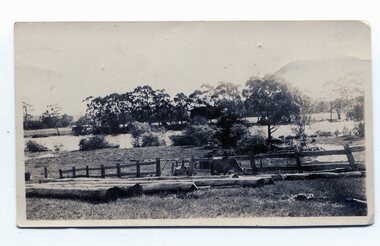
black and white photographs, January 1934
These are photographs taken during the 1934 flood at Orbost. From The Argus (Melbourne) on January 10 1934 "Damage estimated at £500,000 has been caused by the floods in the Orbost district. No loss of life occurred, largely owing to the heroic efforts of rescue parties. Many families spent Monday night on the roofs of houses or in trees, surrounded by deep, rushing flood waters." This 1934 flood was devastating, destroying a section of the 1922 Orbost bridge - the centre span was washed away -. wrecking fences, bridges and roads, dumping silt and debris on the rich river flats and drowning cattle.These photographs are pictorial records of the 1934 floods at Orbost, a significant event in the history of Orbost.Nine small black / white photographs of flood damage,3253.2 on back - "Waters rushing down Princes Highway and....of......where you see the waves" 3253.3 on back - "rushing flood waters over Lochiel Park Bridge approach at the rear of picture 1934"orbost-flood-1934 flood-orbost -
 Ringwood and District Historical Society
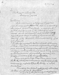
Document, Council flood relief for Mullum Creek flood in Ringwood in 1934
Hand written letters to Ringwood Council re flood relief.Correspondence to Council from Ratepayers asking for flood relief resulting from the flood damage in the vicinity of Harrison Street bridge over Mullum Creek in 1934. -
 Orbost & District Historical Society
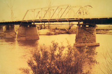
photograph, first half of 20th century prior to 1976
Purchased from Orbost Op shop several years ago. Original owner unknown. This bridge over the Snowy River was opened on July 4 1922. It was constructed in 1922 alongside the previous suspension bridge. Its building was a combined effort of the Victorian Railways and the Country Roads Board at a cost of 35,000 pounds. It was replaced in 1976 by the present bridge after several major floods.This bridge was replaced in 1976 after several major floods.A wooden framed photograph of the second Snowy River bridge at Orbost.photograph snowy-river-bridge -
 Orbost & District Historical Society
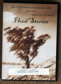
D.V.D, Flood Stories, 2006
In October 2006, Orbost Secondary College 9/10 Enhancement Studies Class worked to preserve the memories of the Orbost community with three short films describing recollections of Orbost floods. There are ten stories including memories of the 1952, 1971 and 1991 floods. They are narrated by various Orbost identities - Anne Bridges; Kay Lynn; Ken Edlington; Margaret Adams; Max Reynols; Shirley Reynolds and Ngaere Donald.Floods have been part of the history of Orbost since settlement. These stories record impressions of local people.A D.V.D. in a black plastic case. On the cover ia a brown sketch of a tree. Above in black print is the title, "Flood Stories" with " Year 9/10 Enhancement Studies 2006 presents" at the top.sticker and stamp - Orbost & District Historical Society -
 Marysville & District Historical Society
Photograph (item) - Colour photograph, Pre 2009
A colour photograph of the pumping station at Steavenson Falls in Marysville in VictoriaA colour photograph of the pumping station which is situated at Steavenson Falls in Marysville in Victoria. The pumping station provides power to the floodlights which then lillumniate the falls every night between sundown and 11.00pm. The Steavenson Falls is named after the Victoria Assistant Commissioner of Roads and Bridges, John Steavenson who arrived in Victoria in the early 1860's.pumping station, steavenson falls, marysville, victoria, flood lights, john steavenson -
 Eltham District Historical Society Inc
Negative - Photograph, Harry Gilham, Diamond Creek in flood, looking west towards Eltham High School (across submerged footbridge), c.Aug. 1996
This (submerged) footbridge has since been replaced by a higher-level bridge and the steps have been abolished.Roll of 35mm colour negative film, 5 of 6 stripsKodak Gold 100-5diamond creek, floods, dalton street, wingrove park trail, eltham high school -
 Bendigo Historical Society Inc.
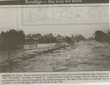
Newspaper - JENNY FOLEY COLLECTION: AWASH
Bendigo Advertiser ''The way we were'' from 2000. Awash: the Golden Square swimming pool is swamped in this photo of the flooded Bendigo Creek about 1949. The picture was taken on Maple St. looking towards Howard's Bridge, and the diving tower and springboard at the pool can be seen in the centre foreground. The date of the photo is unknown, but is believed to have been taken prior to the floods of late 1949. The clip is in a folder.newspaper, bendigo advertiser, the way we were -
 Port Melbourne Historical & Preservation Society
Plan - Proposed bridge under Hobsons Bay railway at Clarendon Street, Emerald Hill, 1854 - 1884
Plan of proposed bridge under Hobson's Bay Railway at Clarendon Street, Emerald Hill, affecting Sandridge railway and Sandridge Road. Flood level re Sandridge line is shown.transport - railways, flood, emerald hill, town planning -
 Bendigo Historical Society Inc.
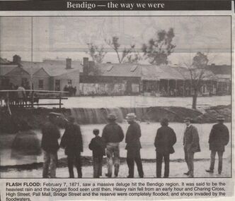
Newspaper - JENNY FOLEY COLLECTION: FLASH FLOOD
Bendigo Advertiser "The way we were'' from 1999. Flash flood: February 7, 1871 saw a massive deluge hit the Bendigo region. It was said to be the heaviest rain and the biggest flood seen until then. Heavy rain fell from an early hour and Charing Cross, High Street, Pall Mall, Bridge Street and the reserve were completly flooded, and shops invaded by the floodwaters.newspaper, bendigo advertiser, the way we were -
 Bendigo Historical Society Inc.
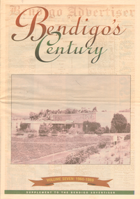
Newspaper - LONG GULLY HISTORY GROUP COLLECTION: BENDIGO'S CENTURY VOLUME SEVEN: 1960 - 1969
Supplement to the Bendigo Advertiser, December 15, 1999 Volume Seven: 1960-1969 titled Bendigo's Century. The front has a photo of the BCV 8 Studio. Contains photos and local news, council matters, planning, Who's Who, Weather, Sport and Business and some Advertisements. Photos include Early stages in the construction of the Eppalock tower and bridge pillars, Christine Wiseman, TV8's first news reader Ron Alderton, Dr Albert L Beischer, Advertiser buiding, fire at the Advertiser building, Oscar Flight, Bendigo Town Hall, William Basil Ashman, Lake Eppalock, Premier Henry Bolte, Que O'Hoy, Sandhurst Guest House, The Lyric Theatre, E C Thompson, The elm tree in Market Square, Leslie Galvin, The original Myer Store, The Joss House, Sidney Myer, Bendigo Police Barracks, Bunratty Castle, Albert Vivian Gray, The Victoria Hill site, Architects drawing of the new council administrative offices and Noel Beaton MHR.bendigo, history, long gully history group, the long gully history group - bendigo's century volume seven: 1960 - 1969, bendigo advertiser, bcv 8, eppalock dam, premier henry bolte, the criterion hotel, mccarthy family, teachers training college, bendigo original teachers college, long gully state school, stramit, bendigo university site committee, mrs christine wiseman, bendigo city council, the broadcasting control board, general television pty ltd, bendigo central victoria telecasters pty ltd, mr davidson, bennett's arcade, woolworth's, white hills swimming pool, herb elliott, sailor's guide, toni riley pharmacies, rising sun hotel, ron alderton, dr albert l beischer, channel 8, melbourne herald, 3bo, bendigo advertiser officeslyceum theatre, junior technical school white hills, mount alvernia hospital, most reverend dr b d stewart, sisters of the franciscan missionaries of the divine motherhood, lazarus family, bendigo's tramways, state electricity commission, george pethard, lance pethard, bendigo advertiser fire 29/7/1962, riverine herald, the herald and weekly times, bendigo art gallery, oscar flight, hollands foundry, eaglehawk u.f.s. dispensary, gillies famous pies, william basil ashman, golden gate hotel, grieves family, bendigo town hall, mr r r anderson, mr e h brown, cr neville oliver, cr tom flood, traffic commission, lansell family, abev-1, bendigo ordnance factory, actu, bendigo trades hall council, the ramsay report, bendigo benevolent home, bendigo home and hospital for the aged, princess theatre, amoco, lake eppalock, bendigo training prison, bendigo police station lock-up, shamrock hotel, rifle brigade hotel, hopetoun hotel, anz bank, marong shire offices, sir rohan delacombe, st paul's church, que o'hoy, waldron family, windermere hotel, aids & appliance shop, anne caudle centre, e c thompson, mayfair hams, sandhurst guest house, lyric theatre, chinese joss house, ordnance factory, sir john jenson, bridge street chinese quarter, bendigo city hall, cr r f turner, cr tom flood, victorian inland meat authority, new zealand insurance co, mrtropolitan security service, bendigo easter fair society, golden square high school, eaglehawk high school, bendigo technical college, mr ralph w birrell, bendigo fountain plaza, the bethlehem home for the aged, dick hazeldene, victorian egg board, bendigo united cricket club, south bendigo united cricket club, western mining corporation, les priest, alexandra fountain, bendigo advertiser, cr w cambridge, bendigo council, eaglehawk council, strathfieldsaye shire, huntly shire, marong shire, david thomas, senator john gorton, bendigo's college of advanced education, bank of new south wales, harp and shamrock hotel, the honorable leslie william galvin, kurmala, cain government, hanro knitting mills, myer store, sidney myer, davey brothers grocery store, national trust, myer emporium, myer's ltd, cox bros (australia) ltd, dame merlyn myer, baillieu myer, frank greenaway, institute of technology, gas & fuel corporation, bendigo railway station, anz bank, city family hotel, tab branch, senior constable alfred herbert wright, senior constable allan raymond brown, victorian football league, bendigo police barracks, camp hill state school, state electricity commission, the country party, the labor party, transport regulation board, stuart anderson, grose family, jean theodore de ravin, kyneton shire, sir william mcdonald, mines department, the loddon hospitals region group laundry and central linen service, kevin wynne, albert vivian gray, bradford cotton mills ltd, bradmill industries ltd, victoria hill, bendigo and district tourist association, professor brian lewis, melbourne university, victorian chinese community, loong, sun loong, stafford ellinson, coles' store, north deborah mining company nl, noel beaton mhr, durham ox hotel, taylor family -
Clunes Museum
Photograph, 2010
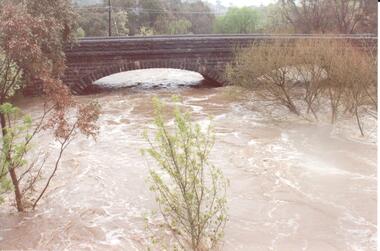
.1 Bridge was damaged and closed for repairs for about 6 months .2 Government bridge is higher and was not damaged.1 colour photograph of flooded creek at the newer bridge, water is hitting the bridge .2 colour photo of Government bridge during the floods, water is below the top of the bridge.1 T. Goldworthy 4th Sept. 2010 about midday .2 T. Goldworthy 4th Sept. 2010 about middaybridges, floods, photograph, goverment bridge -
Clunes Museum
Photograph
3 X COLOUR PHOTOGRAPHS TAKEN AT MT CAMERON ROAD BRIDGE OF THE FLOODS OF AUGUST TO SEPTEMBER 2010 PHOTOGRAPHS WERE TAKEN ON 12/08/2010 AND 04/09/2010STICKER ON THE BACK OF PHOTOGRAPH: MC. EILEEN BRADSWORTH, CLUNESflood 2010, mt cameron road bridge -
Clunes Museum
Photograph
... BRIDGE FLOOD FLOOD CRESWICK CREEK 1909 FLOOD 8/9/1909 TALBOT RD ...COPY OF PHOTOGRAPH OF FLOOD ON CRESWICK CREEK AT SUSPENSION BRIDGE BEHIND KEEBLE'S 8/9/1909 TALBOT RD CLUNES. IT WAS THIS BRIDGE THAT MR. WATSON WAS SO NEARLY CARRIED DOWN WITH THE RUSHING WATERS. HE WAS STANDING ON PART OF IT, WHEN IT BROKE AWAY AND HE MANAGED TO CLING TO TO THE REMAINSsuspension bridge flood, flood creswick creek, 1909 flood -
Clunes Museum
Photograph
COPY OF PHOTOGRAPH OF FLOOD ON CRESWICK CREEK AT GOVERNMENT BRIDGE12/9/1909 FROM CLUNES TALBOT RD. MOTHER WRITING TO AMY. CLUNES JUBILEE BRIDGE DURING THE SEVERE FLOOD, WHEN AT ITS HIGHEST MARK. IT REMINDED ME OF SEA WAVES. THE WATER WAS AT OUR FEET AS WE STOOD WATCHING IT IN MRS BARKELL'S COW YARD. MRS BARKELL AND MARY WHITE (THE WRITER) TOOK IT IN TURNS TO COOK DINNER AND WATCH THE FLOODflood 1909, mrs a white, flood creswick creek -
 Hume City Civic Collection
Photograph
The series of photographs were taken after exceptional heavy rain had fallen in Sunbury in the early 1990s. Jackson's Creek overflowed its banks and the surrounding flood plain area was under water.A coloured photograph of Jackson's Creek in flood. The floodwaters have almost reached the top of the arch of the Macedon Street stone bridge.floods, weather patterns, jacksons creek, george evans collection -
 Hume City Civic Collection
Photograph, 14/08/1909
The Jackson Creek flooded on 14 August 1909 when the creek was 32 feet above sea level.A sepia photograph of the Jackson Creek in flood. Goonawarra winery is in the background. Unmounted postcardjackson's creek, goonawarra farm, sunbury, floods, gregor, bob, billinghurst, beryl, francey, sandra, alex, bridges, macedon street bridge, george evans collection -
 Clunes Museum
Photograph
SUSPENSION BRIDGE WAS SWEPT AWAY IN A FLOOD ABOUT 1909.BLACK AND WHITE PHOTOGRAPH SHOWING THE SUSPENSION BRIDGE IN FOREGROUND, GOVERNMENT BRIDGE IN CENTRE.MAYBE THIS IS THE SWING BRIDGE WHICH WAS SWEPT AWAY ABOUT 1909. IT WAS ABOVE EBERHARD'S CORDIAL FACTORY.local history, photography, bridges, suspension bridge -
 Kew Historical Society Inc
Photograph, Marnie McLeod, Floods of the River Yarra at Kew, 1916
The donation was accompanied by the following letter from the donor: "Hi. I found these in with family photos. Taken by family as Mamie McLeod was living in Fellows Street, Kew, so would be near there. Retain (or discard) as you see fit." [Donor's name and address withheld from public view]. To gain an insight into the flood levels at Kew, it is worth reading newspaper accounts of the event. The Age published an article - Valuable Gardens Destroyed at Kew - on 25 September 1916: "VALUABLE GARDENS DESTROYED AT KEW. From the heights of Studley Park, Kew, a splendid view of the flood waters can be obtained, and yesterday afternoon, despite continuous rain, crowds of citizens assembled there to witness the spectacle. There is a vast stretch of water some 300 or 400 yards broad, above the foot bridge connecting Gipps-street, Collingwood, and Studley Park. The river is only about 3 feet from the top of the embankment connecting with the ramp of the bridge on the Studiey Park side. When the upper llood waters come down it is almost a certainty that tne embankment will be submerged and the bridge rendered impassible. Below the bridge the waters again stretch out, and have submerged all the low-lying land on the Collingwood side and invaded the back premises ot the Kodak Co., Phoenix Biscuit Factory, a tannery adjoining thereto, the Shamrock Brewery, and Chinese gardens in the vicinity. At Walmer-street-bridge, at the end of Studley Park, the low-lying land on the Kew side is covered with water to the depth of many feet. Tlie land in question is owned in a great part by Mr Frank Lavers who haa gone in for intense culture on a pretty liberal scale on both the slopes of the hill and on the river flat. On the latter he is cultivating many acres of asparagus, and has at a considerable cost spent three years in preparing the ground and installing an irrigation system, reticulated from the Yan Yean water supply. This year the asparagus was put down, and the plants were in a promising condition. Tlie flood waters are now flowing fast over the land. The crop is ruined, and three years' work and expenditure destroyed. Mr. Laver's private residence fortunately is high above flood level, but two houses he owns off Young-street have been flooded out. Having been warned in time, the tenants removed their furniture hefore the water came down to Mr. Laver's residence, where they themselves have been given accommodation in the meantime. All the river flats in East Kew are under water. One or two low-lying houses have been flooded. Chipperfield's boat shed at Willsmere is nearly covered, and some Chinese gardens in the vicinity are several feet under water."This, and the other three photographs donated of floods in Kew are believed to be the earliest in the collection. Together with our original MMBW River Yarra map showing flood levels, these items, when compared allow researchers to gain a visual perspective of the extent of the flood in 1916. Black and white photograph of flooded trees in Kew with rising dry ground in distance.Inscription on reverse in pencil: "Flood River Yarra Kew Vic"river yarra, kew, floods 1916 -
 Kew Historical Society Inc
Photograph, Marnie McLeod, Floods on the River Yarra at Kew, 1916
The donation was accompanied by the following letter from the donor: "Hi. I found these in with family photos. Taken by family as Mamie McLeod was living in Fellows Street, Kew, so would be near there. Retain (or discard) as you see fit." [Donor's name and address withheld from public view]. To gain an insight into the flood levels at Kew, it is worth reading newspaper accounts of the event. The Age published an article - Valuable Gardens Destroyed at Kew - on 25 September 1916: "VALUABLE GARDENS DESTROYED AT KEW. From the heights of Studley Park, Kew, a splendid view of the flood waters can be obtained, and yesterday afternoon, despite continuous rain, crowds of citizens assembled there to witness the spectacle. There is a vast stretch of water some 300 or 400 yards broad, above the foot bridge connecting Gipps-street, Collingwood, and Studley Park. The river is only about 3 feet from the top of the embankment connecting with the ramp of the bridge on the Studiey Park side. When the upper llood waters come down it is almost a certainty that tne embankment will be submerged and the bridge rendered impassible. Below the bridge the waters again stretch out, and have submerged all the low-lying land on the Collingwood side and invaded the back premises ot the Kodak Co., Phoenix Biscuit Factory, a tannery adjoining thereto, the Shamrock Brewery, and Chinese gardens in the vicinity. At Walmer-street-bridge, at the end of Studley Park, the low-lying land on the Kew side is covered with water to the depth of many feet. Tlie land in question is owned in a great part by Mr Frank Lavers who haa gone in for intense culture on a pretty liberal scale on both the slopes of the hill and on the river flat. On the latter he is cultivating many acres of asparagus, and has at a considerable cost spent three years in preparing the ground and installing an irrigation system, reticulated from the Yan Yean water supply. This year the asparagus was put down, and the plants were in a promising condition. Tlie flood waters are now flowing fast over the land. The crop is ruined, and three years' work and expenditure destroyed. Mr. Laver's private residence fortunately is high above flood level, but two houses he owns off Young-street have been flooded out. Having been warned in time, the tenants removed their furniture hefore the water came down to Mr. Laver's residence, where they themselves have been given accommodation in the meantime. All the river flats in East Kew are under water. One or two low-lying houses have been flooded. Chipperfield's boat shed at Willsmere is nearly covered, and some Chinese gardens in the vicinity are several feet under water."This, and the other three photographs donated of floods in Kew are believed to be the earliest in the collection. Together with our original MMBW River Yarra map showing flood levels, these items, when compared allow researchers to gain a visual perspective of the extent of the flood in 1916. Panoramic view, believed to be looking north towards Fairfield from the Zig-Zag Bridge on the River Yarra. The inscription on the reverese identifies it as taken before 1920.Inscription on reverse in ink "(pre 1920) Flood from Zig-zag bridge Yarra River, Kew Vic."river yarra, kew, floods 1916, zig-zag bridge -
 Kew Historical Society Inc
Photograph, Marnie McLeod, Flood, River Yarra, Kew, 1916
The donation was accompanied by the following letter from the donor: "Hi. I found these in with family photos. Taken by family as Mamie McLeod was living in Fellows Street, Kew, so would be near there. Retain (or discard) as you see fit." [Donor's name and address withheld from public view]. To gain an insight into the flood levels at Kew, it is worth reading newspaper accounts of the event. The Age published an article - Valuable Gardens Destroyed at Kew - on 25 September 1916: "VALUABLE GARDENS DESTROYED AT KEW. From the heights of Studley Park, Kew, a splendid view of the flood waters can be obtained, and yesterday afternoon, despite continuous rain, crowds of citizens assembled there to witness the spectacle. There is a vast stretch of water some 300 or 400 yards broad, above the foot bridge connecting Gipps-street, Collingwood, and Studley Park. The river is only about 3 feet from the top of the embankment connecting with the ramp of the bridge on the Studiey Park side. When the upper llood waters come down it is almost a certainty that tne embankment will be submerged and the bridge rendered impassible. Below the bridge the waters again stretch out, and have submerged all the low-lying land on the Collingwood side and invaded the back premises ot the Kodak Co., Phoenix Biscuit Factory, a tannery adjoining thereto, the Shamrock Brewery, and Chinese gardens in the vicinity. At Walmer-street-bridge, at the end of Studley Park, the low-lying land on the Kew side is covered with water to the depth of many feet. Tlie land in question is owned in a great part by Mr Frank Lavers who haa gone in for intense culture on a pretty liberal scale on both the slopes of the hill and on the river flat. On the latter he is cultivating many acres of asparagus, and has at a considerable cost spent three years in preparing the ground and installing an irrigation system, reticulated from the Yan Yean water supply. This year the asparagus was put down, and the plants were in a promising condition. Tlie flood waters are now flowing fast over the land. The crop is ruined, and three years' work and expenditure destroyed. Mr. Laver's private residence fortunately is high above flood level, but two houses he owns off Young-street have been flooded out. Having been warned in time, the tenants removed their furniture hefore the water came down to Mr. Laver's residence, where they themselves have been given accommodation in the meantime. All the river flats in East Kew are under water. One or two low-lying houses have been flooded. Chipperfield's boat shed at Willsmere is nearly covered, and some Chinese gardens in the vicinity are several feet under water."This, and the other three photographs donated of floods in Kew are believed to be the earliest in the collection. Together with our original MMBW River Yarra map showing flood levels, these items, when compared allow researchers to gain a visual perspective of the extent of the flood in 1916. Small black and white photograph of flooded trees in Kew.Inscription on reverse in ink "Flood R. Yarra Kew Vicriver yarra, kew, floods 1916 -
 Kew Historical Society Inc
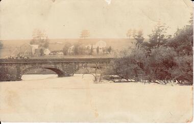
Print - Walmer Street Foot Bridge
A bridge to Walmer Street, Kew, from Abbotsford was located at the northern end of Burnley Street. It was a foot bridge.Photographic print of the Walmer Street Bridge. The view of the Bridge is from the Abbotsford side of the Yarra. A section of pipe on the near side of the bridge is a remnant of the irrigation pipes that carried water from above Dight's falls to the Melbourne Botanic Gardens. The former bridge, constructed in 1896 was swept away in the 1901 Flood. It has two major brick piers while the remainder of the trestle supports are metal. The original photograph from which this copy was made was taken after 1901 as it shows the second bridge under construction. Houses in Young Street, Kew, can be seen on the far side of the river.Written on reverse: "Walmer St. Bridge. Erected 1896. Being rebuilt after 1901 flood damaged it. Houses on left are in Young St."bridges -- kew (vic.), walmer street bridge, melbourne botanic gardens -
 Kew Historical Society Inc
Print - Walmer Street Foot Bridge, 1901
Photographic print of the Walmer Street Bridge. The view of the Bridge is from the Abbotsford side of the Yarra. A section of pipe on the near side of the bridge is a remnant of the irrigation pipes that carried water from above Dight's falls to the Melbourne Botanic Gardens. The former bridge, constructed in 1896 was swept away in the 1901 Flood. It has two major brick piers while the remainder of the trestle supports are metal. The original photograph from which this copy was made was taken after 1901 as it shows the second bridge under construction. Houses in Young Street, Kew, can be seen on the far side of the river.Reverse: " Walmer St footbridge 1901 being repaired after flood / Constructed 1892 substantially renewed in 1901 and in 1928 / Rebuilt in 1977 by Kew Council aided by State funding. Won for designer Martin Aylard a New Zealand award presented by the timber Research & Development Assoc / Site of Simpsons Road passenger foot ferry". bridges - yarra river -- kew (vic.), walmer street bridge -- kew (vic.) -
 Kew Historical Society Inc
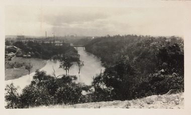
Photograph - Yarra River, Studley Park, 1924
Henry Beater Christian (1886-1962) , was a descendant of one of the earliest settler families in Kew. Employed at the Kew Asylum as a 'public servant', he was a skilled amateur photographer, photographing numerous scenes in Kew and on his travels around Victoria. The majority of his photographs date from 1916 to 1929. His finest photographs are housed in two photograph albums. Digital copy of a photograph from page 7 of the 47-page photograph album containing 261 gelatinous silver images, loaned by Diane Washfold with permission given to digitise and hold a copy in our collection. This photograph was taken during a flood year when the Yarra encroached on the grounds of the Abbotsford Convent. In the distance, the Johnston Street Bridge separates the viewer from the industrialised landscape of Fairfield."Studley Park / Kew"henry beater christian (1886-1962), landscape photography, kew (vic.) — yarra river, christian-washfold collection, photograph albums, fairfield, kew, johnston street bridge, studley park -
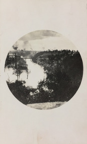 Kew Historical Society Inc
Photograph - Yarra River, Studley Park, 1924
Henry Beater Christian (1886-1962) , was a descendant of one of the earliest settler families in Kew. Employed at the Kew Asylum as a 'public servant', he was a skilled amateur photographer, photographing numerous scenes in Kew and on his travels around Victoria. The majority of his photographs date from 1916 to 1929. His finest photographs are housed in two photograph albums. Digital copy of a photograph from page 7 of the 47-page photograph album containing 261 gelatinous silver images, loaned by Diane Washfold with permission given to digitise and hold a copy in our collection. This photograph was taken during a flood year, perhaps 1923, when the Yarra encroached on the grounds of the Abbotsford Convent. In the distance, the Johnston Street Bridge separates the viewer from the industrialised landscape of Fairfield. In developing the photo, Henry Christian employed a circular frame to artistically focus the view. He empkloyed this technique for what he may have viewed as his best photographs. "Studley Park / Kew"henry beater christian (1886-1962), landscape photography, kew (vic.) — yarra river, christian-washfold collection, photograph albums, fairfield, kew, johnston street bridge, studley park -
![Junction of the Rivers Yarra and Watt, Near Healesville / [by] Nicholas Caire, circa 1876](/media/collectors/550653872162f11fb04854aa/items/577740e5d0cdd10a5c0de011/item-media/57774153d0cdd10a5c0e0662/item-fit-380x285.jpg) Kew Historical Society Inc
Kew Historical Society IncPhotograph, Anglo-Australasian Photographic Company, Junction of the Rivers Yarra and Watt, Near Healesville, c. 1876
Nicholas Caire was born on Guernsey in the Channel Islands in 1837. He arrived in Adelaide with his parents in about 1860. In 1867, following photographic journeys in Gippsland, he opened a studio in Adelaide. From 1870 to 1876 he lived and worked in Talbot in Central Victoria. In 1876 he purchased T. F. Chuck's studios in the Royal Arcade Melbourne. In 1885, following the introduction of dry plate photography, he began a series of landscape series, which were commercially successful. As a photographer, he travelled extensively through Victoria, photographing places few of his contemporaries had previously seen. He died in 1918. Reference: Jack Cato, 'Caire, Nicholas John (1837–1918)', Australian Dictionary of Biography.An original, rare photograph from the series 'Views of Victoria: General Series' by the photographer, Nicholas Caire (1837-1918). The series of 60 photographs that comprise the series was issued c. 1876 and reinforced a neo-Romantic view of the Australian landscape to which a growing nationalist movement would respond. Nicholas Caire was active as a photographer in Australia from 1858 until his death in 1918. His vision of the Australian bush and pioneer life had a counterpart in the works of Henry Lawson and other nationalist poets, authors and painters.Albumen Silver Photograph, mounted on Board.printed in ink on support l.c.: JUNCTION OF THE RIVERS YARRA AND WATT, NEAR HEALESVILLE. / COPYRIGHT REGISTERED. printed in ink on support reverse c.: VIEWS OF VICTORIA. / (GENERAL SERIES.) / No. 3. / JUNCTION OF THE RIVERS YARRA AND WATT, NEAR HEALESVILLE / The junction is situated about 3 miles from Healesville, and 35 miles from the mouth of the Yarra. The souces / of the Watt are to be found at the head of the Black Spur, and, being fed by a number of creeks and springs, its / waters gain considerable force for several miles before joining those of the Yarra. The "Old Bridge," at the junction, / is the name given to this crossing-place, which has been partly swept away by late floods. The depth of the Yarra here / is from 15 to 20 feet; that of the Watt, about 10 feet. printed in ink on support reverse l.c.l.: J.W. FORBES, Agent, printed in ink on support reverse l.c.: ANGLO-AUSTRALASIAN PHOTOGRAPHIC COMPANY, MELBOURNE. printed in ink on support reverse l.c.r.: 10 Temple Court, Collins Street West.nicholas caire (1837-1918), yarra river, watt river, bridge, wooden bridge, healesville -
![Studley Park [Toll] Bridge, Kew](/media/collectors/550653872162f11fb04854aa/items/579ebf04d0cdd117c4c0815f/item-media/579ebf3ad0cdd117c4c0953e/item-fit-380x285.jpg) Kew Historical Society Inc
Kew Historical Society IncPhotograph, Studley Park [Toll] Bridge, Kew, 1870s
‘Studley Park Bridge’ or ‘penny bridge’ linked Church Street in Abbotsford and what is now Yarra Bend Park. The privately constructed bridge opened in 1857, gaining its popular name from the toll charged at the Abbotsford end. The engineer of the 485ft wide bridge was Mr. Austin and the builder was ‘Mr Grant, who threw the bridge over the Niagara’. Following the opening of Johnston Street Bridge, declining tolls led to the Bridge falling into disrepair. Badly damaged by the flood of 1891, the Bridge was compulsorily acquired by the Government in 1899, and later dismantled and sold for firewood.This work forms part of the collection assembled by the historian Dorothy Rogers, that was donated to the Kew Historical Society by her son John Rogers in 2015. The manuscripts, photographs, maps, and documents were sourced by her from both family and local collections or produced as references for her print publications. Many were directly used by Rogers in writing ‘Lovely Old Homes of Kew’ (1961) and 'A History of Kew' (1973), or the numerous articles on local history that she produced for suburban newspapers. Most of the photographs in the collection include detailed annotations in her hand. The Rogers Collection provides a comprehensive insight into the working habits of a historian in the 1960s and 1970s. Together it forms the largest privately-donated collection within the archives of the Kew Historical Society.A print, taken in the 1960s by Dorothy Rogers, from an original albumen silver photograph now in the collection of the Kew Historical Society. The photograph shows the toll bridge (also known as the Penny Bridge) from the northern end."P[enny] Toll Bridge - built 1857. from old photo"studley park bridge, penny bridge, bridge, timber bridge, toll bridge -
 Kew Historical Society Inc
Postcard, R McGeehan, The Effect of Storm. Train Passing Through Flood Waters, South Yarra, 25-1-07, 1907
SHARP DOWNPOUR. ONE INCH IN 45 MINUTES. SOUTHERN SUBURBS DELUGED. TRAIN STOPPED AT SOUTH YARRA. One of the sudden downpours of rain which occasionally fall in Melbourne occurred yesterday afternoon, when nearly an inch of rain fell in the course of three quarters of an hour, and caused a flood for an hour or two in certain localities. During the early part of the day, the sky had been clouded over, but there was nothing to indicate a storm of such intensity as that which followed. At about half-past 1 o'clock residents of South Yarra, South Melbourne, Prahran, and St. Kilda noticed a few drops of rain. Still, it appeared unlikely that there would be anything exceptional, until with startling suddenness at about 10 minutes to 1 o'clock, one of the heaviest downpours within the memory of residents burst upon those suburbs. A strange feature of the storm was that it was practically confined to an area of about three miles square. The city was but little affected, though at a spot as close as the Observatory 86 points of rain were recorded in three-quarters of an hour. Thunder and lightning accompanied the downpour, which was cyclonic in character, the rain driving heavily from all points of the compass as the cyclone passed. It was in South Yarra and Prahran that the rain fell heaviest. Within a few minutes after it commenced, the low-lying portions of Toorak-road and practically the whole length of Chapel-street were under water. The depression at the intersection of Toorak-road and Darling-street speedily filled to the dimensions of a small lake. Several shops were inundated, while the water from the higher levels rushed down like a mountain torrent, and in several in-stances swept through the rear of houses and shops, carrying furniture in a floating mass against the further walls. In one case a footbridge was carried bodily away and dashed to pieces. Darling-street itself Great Davis-street, and other low-lying and flat thoroughfares in the vicinity became flooded from kerb to kerb, while on the other side of the railway-bridge the valley between Kensington-road and River-street became filled for some minutes to a depth of several feet. Meanwhile the waters from South Yarra hill, seeking a lower level, found it in the railway cutting, and the excavations from South Yarra station to Prahran on the one line, and to the Chapel-street bridge on the other, were converted into a couple of canals. At the platforms at South Yarra the water was two feet deep on the permanent way, and towards Hawksburn, at the sudden depression under Chapel-street bridge, it was at one time deep enough to cover a tall man's head. Into this swirling mass of water the 1:50 p.m. train from Oakleigh plunged on its way to Melbourne. The impact caused a mighty fountain of water to rise to a height of about 20 feet above the level of Chapel-street and send clouds of spray in all directions. Under the belief that a terrible explosion had occurred residents braved the rain and rushed to the spot, only to find that the train had been brought to a stand-still in the middle of what seemed to be a river. The water was so high that it had entered the fire-box from below, extinguishing the fires and cutting off the steam supply. In the meantime the officials at the South Yarra station had been preparing for emergencies. Inspectors were on duty at intervals along the line, and the moment the alarm was given an extra engine was backed carefully down and continued on to connect with the stranded train without losing its own power. There was a delay of about ten minutes in the service for an hour or two, but by 5 o'clock all the trains were running on time again, and the water had run off all but the spot beneath the Chapel-street bridge. Here the water remained about four feet deep until nightfall, and throughout the afternoon several hundreds of people including biograph operators and photographers, were gathered around watching each train pass through. Even with the water two feet lower, this was a work attended with considerable difficulty. Each train had to absolutely force its way through the weight of water, almost enveloped by the spray thrown up, and it was only just able to negotiate the "ford" by using every ounce of steam. ... The Argus, 26 January 1907, p19.The item forms part of the Laurie Bennett collection of thirty-six postcards and photographs of Kew and early Melbourne, donated to the Kew Historical Society in 1980. The postcards in the Bennett collection, like other images in the Society's holdings date from the 1890s to the present and comprehensively indicate points-of-view or scenes considered historically, aesthetically or socially significant in the period in which they were produced.Postcard depicting a flood at South Yarra Station in 1907. The title and photographer's name are identified on the front of the postcard. Donated by L. Bennett, 1980flood - south yarra, trains - melbourne, postcards, r mcgeehan - prahran -
 Kew Historical Society Inc
Photograph - Burgess House, Victoria Street (Abbotsford), 1880-1900
Major floods recurred of the Yarra River on a regular basis. A flood in 1901 destroyed this house in Victoria Street, Abbotsford. Later print copy of an original photograph. Home of C/N Burgess on the south side of Yarra River. The buildings were washed away in a flood in 1901 The house was in the same location as that on which Handley & Tilly was later built. This would locate it on the north side of Victoria Street, Abbotsford between Burnley Street and the Victoria Street Bridge. Photo shows three men and one woman working in an established garden in front of a weatherboard cottage."Home of C/N Burgess on south side of river; washed away in 1901; Handley & Tilly on site"yarra river -- floods, yarra river flood -- 1901, burgess family -- victoria street -- abbotsford (vic.) -
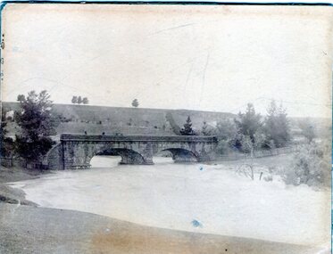 Sunbury Family History and Heritage Society Inc.
Photograph, 1916 - 1917
... bridge. Floods Jacksons Creek Macedon Street Bridge A sepia ...The Jacksons Creek is prone to flooding when rainfall is very heavy. The flood pictured in the photograph occurred either in 1916 or 1917 and reached at a level close to the arches on the Macedon Street bridge.A sepia photograph backed on cardboard of a two arched bridge with a river in flood.floods, jacksons creek, macedon street bridge -
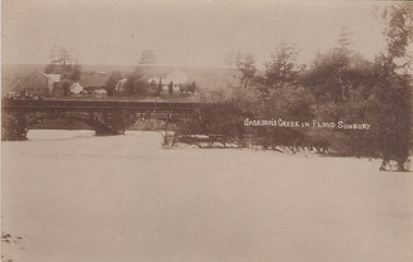 Sunbury Family History and Heritage Society Inc.
Photograph
The post card is a record of a time when the Jacksons Creek flooded and the water almost reached the two arches on the Macedon Street Bridge. The Goonawarra Winery buildings can be seen in the back ground.A sepia photograph in post card format of a river in flood with the water almost reaching the two arches on the stone bridge. Farm buildings can be seen in the middle distance.JACKSON'S CREEK IN FLOOD SUNBURYmacedon street bridge, jacksons creek, goonawarra winery