Showing 273 items
matching campus map
-
 Federation University Historical Collection
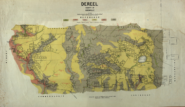
Map, Dereel, County of Grenville, 1890, 1890
Dereel is in western Victoria.Geological map of Dereel in the County of Grenville featuing six colours (predominantly grey and yellow). WGS 84 Centroid Lat: 37 degrees 48 feet 50 inches S Long:143 degrees 42 feet 10 inches S N-S: 6.4 km E-W: 15.2 km dereel, ferdinand krause, crown lands department, plan -
 Federation University Historical Collection
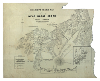
Map, Dead Horse Creek, 1887, 29/05/1887
Geological sketch map of a portion of Dead Horse Creek. WGS 84 Centroid Lat: 36 degrees 50 inches S Long: 148 degrees 00 inches S NS: 4.3km EW 4.8kmdead horse creek, james stirling, gold, geology, mount cobberas -
 Federation University Historical Collection
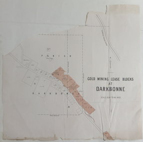
Plan, Goldmining Lease Blocks at Darkbonne, c1887
This map was originally inserteed into the Reports of Mining Registrars for the Quarter ender 30th June 1887.Paper plan showing Goldmining Lease Blocks at Darkbonne, north west of and near St Arnaud, on the Sunraysia Highway. darkbonne, st arnaud, new bendigo mine, alpha mine, working miners mine, chinese camp, donald/st arnaud railway, saint arnaud, darkbonne state school -
 Federation University Historical Collection
Plan, Ballarat East, 1957, 1957
Dr George Clendinning and others were trustees of the Church of England (St Paul's) A number of enlargements of the Ballarat East maps. .4) Bakery Hill, Humffray Street, Victoria Street, Ballarat Youth Council .5) Specimen Vale, Victoria Street, Eureka Street, Housing Commission .10) - Tomber Reserve, York Street, Spencer Street, Bennett Street, Wilson Street, Rodier Street, Richard Street, Fussell Street, Turpie Street, Stockade Street, Ballarat Rifle Range Lal La Street, Clayton Street, Eureka Street Sheet 2 - Yarrowee Creek, High Street, Dinney's Dam, Binney Street, Oliver Street, Humffray Street, Morres Street, Finch Street, Scotts Parade, Rice Street, HOrnby Street, Queen Street, Newman street, King Street, Napier Street, Sim Street. Sheet 3 - Russell Square, Victoria Street, Orphan Asylum, Ballarat Orphanage, Lofven Street, Haines Street, Yarrowee Creek, Ching Who Coey, Chinese, Stawell Street, Rice Street, Lane Street, Humffray Street, Nelson Street, Coffield Street, Morres Street, Western Highway, Rodier Street, Scott Parade, Canterbury Street Sheet 4 - Orphan Asylum, Ballarat Orphanage School, Fortune Street, Scotts Parade, Water Street, Ritchie Street, Humffray Street, Brophy Street, Thompson Street, Victoria Street,Humffray Street Church of England Reserve, Strickland Parade. Mount Xavier Recreation Reserve, Charlesworth Street Catholic Church Reserve. Sheet 5 - Western Highway, Mount Street, Fortune Street, Finlay Street, Jones Street, Ryan Street, Water Street, Brandbury Street, Humffray Street. Sheet 6 - Barkly Street, Ebden Street, Grenville Street, Cameron Street, Peel Street, Young Street, Victoria Street, Steinfeld Street, Haymes Street, Bond Street, Anderson Street, Eastwood Street, Mair Street, East Street, Haymes Crescent Sheet 7 - Murphy Street, Queen Street, Dyte Parade, Princes Street, Midland Highway, York Street, Dodds St, Wilson St Otway Street, Specimen vale, King Street, Gray Street, Little Dodds Street, Eureka Street. Sheet 9 - Richards Street, Fussell Street, Stockade Street, Orphan Asylum, Ballarat Orphanage, Elford Street, Russell Street, Ross Street, Charlesworth Street, Lalor Street, Stockade Street, Wilson Street, York Street, Eureka Street Sheet 10 - Eureka Street, York Street, Elford Street, Wilson Street, Mount Street, Turpie Street, Timber Reserve, Mount Xavier Sheet 11 - Yarrowee Creek, Humffray Street, Barkly Street, Morton Street, Cobden Street, Morton Street Wesleyan Church, Pryor Street, Albion Street, Bradshaw Street, Ballarat Woollen Mills, Tannery, Mount Pleasant. Sheet 12 - Magpie Street, Grant Street, Gladstone Street, Cobden Street, Fraser Street, Grenfell Street, Robertson Street, Bond Street, Barkly Street, Vine Street, Sovereign Hill, Ballarat Observatory, Pearce Street, Bond Street. Sheet 13 - Murphy Street, Larter Street, midland Highway, Geelong Road, gales Street, Lal Lal Street, Clayton Street, Dodds Street, Elsworth Street Sheet 14 - Eureka Street, Eureka Stockade Memorial Park, Eureka Stockade Reserve. York Street, Joseph Street, Kline Street, Charlesworth Street, Chamberlain Street, Trevor Street, Belford Street, Queen Street, Murray Street, Eureka Tiles, Orphan Asylum, Ballarat Orphanage. Sheet 18 - Scotts Parade, Stawell Street, Fortune Street, Victoria STreet, Railway Line, Haines Street, Eureka Street, Elford STreet, Brophy Street, York Street, Clayton Street, Elsworth Street, Barkly Street, Humffray Street, Midland Highway, Princes Street ballarat youth council, ballarat east, bakery hill, humffray street, victoria street, st paul's anglican church, humffray street state school -
 Federation University Historical Collection
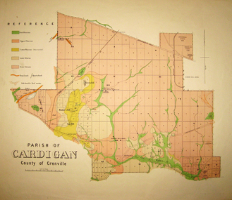
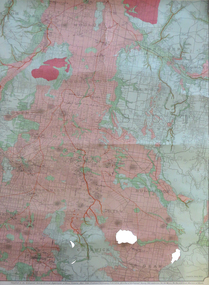
Map - Geological survey, Parish of Cardigan, County of Grenville, c1889
Geological map of the Parish of Cardigan on a cadastral base showing quartz reefs, shafts, alluvial deposits.cardigan, winter's creek, ballarat cattle yards railway, prince of wales park, ballarat, friendly societies reserve, ballarat industrial school reserve, green hill, bunker's hill, sago hill, diamond drill bores, cardigan propriety, half way house, ti tree creek, albion consols, prince imperial, winter's freehold company -
 Federation University Historical Collection
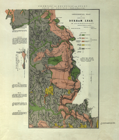
Plan, Durham Lead, 1870
Geological Map of portions of Durham Lead. durham lead, reginald a.f. murray, plan, garibaldi, garibaldi company, geology, chryseis company, hardies hill, city of manchester company, williamson's creek, south grenville company, enfield company, pioneer company, duke of northumberland company, monmowth gully, extinct volcano crater, mount mercer basalt -
 Federation University Historical Collection
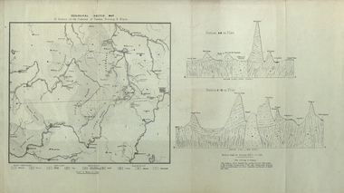
Map, Geological Sketch Map of of Dundas, Berung, and Ripon Counties
Map of the Counties of Dundas, Berung, and Riponcounty of dundas, county of berung, county of ripon, map, geology, ararat, stawell, hamilton, grampians -
 Federation University Historical Collection
Map, Creswick, Clunes, Smeaton, Newstead, Yandoit and District, 1904, 06/1904
A coloured geological map with green and pink predominating. The shows Ascot, Creswick, Clunes, Franklinford, Miners Rest, Sandon, Smeaton, Tourello, Yandoitascot, creswick, clunes, franklinford, miners rest, sandon, smeaton, tourello, yandoit, mt moorookyle, powlett's hill, woodhouse's hill, smeaton hill, mcdonald's hill, green hill, spring hill, horse shoe hill, mt cameron, strangways, avoca forest, stanley hunter, j.w. gregory, d. mcleod, donald mcleod, daruel -
 Federation University Historical Collection
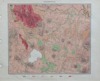
Map, Geological Map of Learmonth, 1882, 10/1882
Two copies: (printed noted attached) 3.) Rectangular geological map edged in masking tape. Six colours define geology and are predominantly pink. Scale 40 chains to one inch .4) Notes referring to the Geological Map of Learmonth learmonth, lake learmonth, glendaruel, burrumbeet, mt blowhard, morton's hill, mt bolan, addington, mt cavern, coghill's hill, mt hollowback, mt pisgah, weatherboard hill, webster's hill, foster's hill, mt bolen, one mile hill, vaughan's hill, tourello stattion, ballarat to maryborough railway, saddleback hill, ceres, brown's hill, ross's hill, norman taylor, robert burrows, richard shephard, james finnie -
 Federation University Historical Collection
Plan, Shire of Buninyong Warrenheip water supply general management
The Shire of Buninyong was later amalgamated into the City of Ballarat.Map shows the 1966 district boundaries of Ballarat and the layout of properties and water pipes in Warrenheip 1966.Gutteridge, Haskins & Davey Consulting Engineers Shire of Buninyong Warrenheip water supply general management September 1966buninyong, vincent, warrenheip, gutteridge, haskins & davey, water supply -
 Federation University Historical Collection
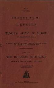
Book, William Baragwanath, Memoirs of the Geological Survey of Victoria No 14: The Ballarat Goldfield, 1923, 1923
257 page foolscap pink covered book relating to the Ballarat goldfields plus 32 plates of maps and sections. william baragwanath, mining, geological survey of victoria, ballarat, goldfields, raglan street, ballarat -
 Federation University Historical Collection
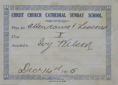
Books, Prize Books Awarded to Ivy Wilson, 1915-18
Three hard covered books which were awarded to Ivy Wilson as prizes. .1) Holiday Times .2) In the Master's Footsteps .3) The Prize for Girls and Boys Gift of Nola Jones, daughter of Ivy Wilson, 2016.1) Special Prize given by Miss Wilson to Ivy Wilson, G.F.S. Candidate, Christ Church Branch, 11.12.15 .3) Presented to Ivy Wilson for Best Maps Grade VIa S.S. No. 34 20/8/18christ church ballarat, girls' friendly society, ivy wilson, bookplate, christ church cathedral sunday school bookplate, christ church cathedral sunday school prize plate, prize plate, humffray street state school no. 34, books, christmas, fairies, school, education, teacher, student, father christmas, santa claus, christmas tree, premium plate -
Federation University Historical Collection
Photograph - Black and White, Former Ballarat Library, c1960
First known development on this site was the establishment of the Government Camp from the early 1850s. It was established to accommodate officials, troopers and police who were needed to administer the goldfields. Some permanent buildings were constructed. Lack of materials and bad weather prolonged the building of more permanent buildings and most men were still living in tents. Area was known as Camp Reserve. In 1864 a subdivision map shows the reserve be used for Public Buildings. Library applied for land on corner of Sturt and Camp Streets in 1878. 1880s plans show section of the reserve be used for a Free Library and Reading Room. Lease was granted and the old mining boardroom was initially used. Land for additional building to house a Museum and Art Gallery sought and agreement reached in 1882-3. Compensation paid to owners and library granted the land. Plans for a new library building with tower and lantern roof abandoned due to lack of funds. It wasn't until 1895 that a solution to funding was found and the library was able to begin constructing the complex of buildings on the Free Library Reserve. A number of changes have occurred since 1910s - the Classical Revival facade replaced with an angled facade in a stripped Classical style with Art Deco features and high parapet. Building is now part of Federation UniversityPhotograph of former library. Shows a two-storey rendered brick building in a Classical style. Some Art Deco features. Central pair of double windows with single window either side. High parapet above.government camp, goldfields, camp reserve, free library, reading room, sturt street, camp street, museum, art gallery, troopers, police, barracks, camp street -
Federation University Historical Collection
Map, Otways Walks and Waterfalls Map, 2013, 06/2013
Tourist map of the Otways showing the townships of Colac, Lorne, Apollo Bay, Beech Forest, Forrest, Barwon Downs, Deans March, Winchelsea, Gellibrand, Lavers Hill, POrt Campbel, Princetown, Johanna, Timboon, Cobden, Camperdown, Swan Marsh, Simpson, Birregurra, Beeac, Marengo, Wye River, Kennett River, Skenes Creek, Peterboroughcolac, lorne, apollo bay, beech forest, forrest, barwon downs, deans march, winchelsea, gellibrand, lavers hill, port campbel, princetown, johanna, timboon, cobden, camperdown, swan marsh, simpson, birregurra, beeac, marengo, wye river, kennett river, skenes creek, peterborough< marriners falls, beauchamp falls, hopetoun falls, triplet falls, little aire falls, stevensons falls -
 Federation University Historical Collection
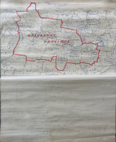
Map, Ballarat Municipalities and City Boundary
Piece of linen attached at top and bottom with wooden rails. Top half of linen has a paper map of Ballaarat Province and Surrounding Municipalities directly attached to it and reads 'Ballaarat Province' in red ink which outlines the greater Ballarat area with surrounding municipalities shown in blue. Scale is '8 miles to 1 inch'. Bottom half is drawn directly onto linen and depicts Ballaarat City Boundary including street names. 'Scale about 20 chains to 1 inch'.ballarat electorate, map, ballaarat province, ballarat to buninyong railway -
 Federation University Historical Collection
Plan, Parish of Dowling Forest, County of Ripon and Grenville, 19
Scale [1:31 680]. 40 chains to 1 in.Geological map on a cadastral base, showing the occurence of reefs, and alluvial deposits. Relief shown by contours.dowling forest, wyndholm, wyndholm pre-emptive right, miners rest, ballarat racecourse, winter's swamp, police reserve, miner's rest, winters swamp, geology -
 Federation University Historical Collection
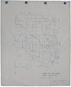
Map, Shire of Ballarat Road Location Map, 1968, 05/06/2014
White paper road location map. Scale 1 mile to 1 inchballarat, shire of ballarat, roads, dowling forest, lake burumbeet, lake learmonth, ascot, windermere, tourello -
 Federation University Historical Collection
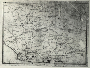
Photograph - Black and White, Map of Western Victoria
WGS 84 37" 47' S 142" 08' EPhotograph of a map showing the Grampians, Glenelg, Portland, Belfast (Port Fairy), Warrnambool, roads and land-holders.western victoria, victoria, belfast, port fairy, warrnambool, manifold -
 Federation University Historical Collection
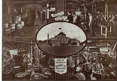
Book, Ballarat Illustrated : Under the Seals of the City & Town Councils, c1920
This book was a donation to Federation University Australia's Professor David Battersby from Vice-Chancellor Professor Scott Bowman of Central Queensland University.Soft cover. Front cover with some red. 80 pages. Back cover Plan of Ballarat Map. Photographic plates. Brief history of Ballarat and the topics photographed. . Ballarat City Municipal Chambers . The Ballarat Banking Company Limited . Art Gallery Ballarat . The Ballarat Trustees, Executors & Agency Company Limited . John MacLeod & Coy Pty Ltd . The Ballaarat Gas Coy . Ballarat's Homes . J. J. Goller & Co. . Ballarat East Views . Star Office . The Ballarat Courier . Morshead's . M. B. John Ballarat - The largest Inland Brass Foundry in Australia . Rowlands Koomah Spa . Huttons the Jewellers . Botanical Gardens Ballarat . Millers the Clothiers . Jas Smith Agricultural Machinery . Views of Lakes Learmonth & Burrumbeet . Coles & Pullum Stock & Station Agents . Harry Davies & Co. . Views about the City . Benoit's Sun Foundry . Ballarat College (for Boys) . Wm Paterson's . Lydiard Street Views . Eureka Terra-cotta & Tile Co. of Australia Limited . Churches of Ballarat . The Ballarat Woollen & Worsted Co. Ltd Sunnyside Mills . Red Shop Tea Rooms . Tyler's - Bridge Street, Ballarat . Allchin Bros Ballarat . Loreto Abbey Mary's Mount Ballarat . Brinds - Dunnstown . Ballarat Brewing Co. . Turnbridge's Arcade . Zoological Gardens Ballarat . A. Cant Plumber & Gasfitter . Interiors of some Ballarat Churches . Hugh Jones & B . W. F. Coltman . Views in Eureka Reserve . Loveland & Haslem, Moter Engineers . Public Institutions Ballarat . G. Warner & Co. Prop. Ltd . The Electric Supply Company of Victoria Limited . Ballarat East Views . Longhurst's Specialities . P. C. Thornton Proprietor Sturt St Ballarat . Cowley's Eureka Ironworks Pty Ltd . W. Owen Sports Depot & Tobacconist . Clarendon Ladies' College . Crocker's . Evening Echo Office . London Bank Chambers . Proprietors of Business . Broadbent Bros & Co. Gifted by Vice-Chancellor Professor Scott Bowman Central Queensland University, 2014.ballarat, school of mines, evening echo, john scullin -
 Federation University Historical Collection
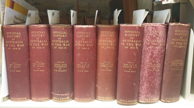
Book, Official History of Australia in the War of 1914-1918, Vol 3, The Australian Imperial Force in France, 1916, 1937
Red hardcovered book of 1035 pages and 475 illustrations and mapsworld war, world war one, charles bean, france, bean, frommelles, messines, somme, pozieres, mouquet farm -
 Federation University Historical Collection
Banner - Book, Charles E.W. Bean, Official History of Australia in the War, Vol 1, The Story of ANZAC: The first phase, 1937
Red hard covered book of 662 pages, 111 maps and 56 illustrations.Inside front in pencil "H.J. Sims"world war, world war one, charles bean, aif, egypt, anzac, sims, h.j. sims -
 Federation University Historical Collection
Book, Charles E.W. Bean, Official History of Australia in the War, Vol 3, The Australian Imperial Force in France, 1917, 1937
Red hard covered book of 1030 pages, with 423 illustrations and maps.world war, world war one, charles bean, aif, anzac, lagnicourt, messines, ypres, menin road, polygon wood, broodseinde ridge, passchendale, hill 60, hill 70, benafay wood, hindenburg line, hooge dump, butte, bapaume, bullecourt -
 Federation University Historical Collection
Book, H.S. Gullett, Official History of Australia in the War, Vol 7, Sinai and Palestine, 1937
Red hard covered book of 844 pages, with 77 maps and 83 illustrations.world war, stretcher, sinai, palestine, gallipoli, turks, light horse, gaza, chetwode, allenby, beersheeba, archibald murray, camels, ambulances -
 Federation University Historical Collection
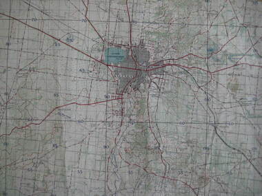
Map, Ballarat, 1936, 06/1936
Map of Ballarat and surrounds, including Lake Learmonth, Snake Valley, Linton, Newton, Durham Lead, Sebastopol, Lake Wendouree, Winter Swamo. It was surveyed in 1933.ballarat, map -
 Federation University Historical Collection
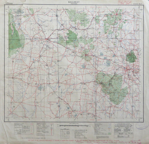
Map, Ballarat, Victoria, 1942, 1942
Two copies of a map of the district around Ballarat, including Creswick, Scarsdale, Smythesdale, Lake Bolac, Ararat, Talbot, Sebastopol, Maryborough, Cardigan, Skipton, Mount Emu Creek, Leigh River, Fiery Creek, Hopkins River. Street names are listed on the back of the map. It includes roads, timber, creeks, rivers, telephone lines, railwayPrinted in red at the base of the map "This map is an official document. If found, itmust be handed in to the nearest Military Headquarters or Police Station.ballarat, map, world war two, skipton, creswick, ararat, lake bolac -
 Federation University Historical Collection
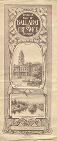
Map, Ballarat and Creswick Districts, 1917, 14/03/1917
"... Three designs have been submitted to the Minister of Lands, at the Department's request, for the cover of a tourists' Guide book of the Ballarat and Creswick Districts. ..." (Ballarat School of Mines Principals Monthly Report, August 1916. Cat. No. 1110.12)A folded map of Ballarat and Creswick Districts which includes tourist destinations such as Creswick, Eureka Stockade, Sturt Street and Coliseum. Drawings are by Amalie Feild.ballarat, creswick, feild, amalie feild, ballarat town hall, park lake creswick, eureka memorial, university women -
 Federation University Historical Collection
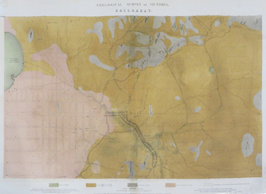
Map - Map - Geological, Ballarat, 1858, 10/1858
Four colour geological map of Ballarat.map, ballarat, geology, black hill, golden point, povery point -
Federation University Historical Collection
Map, Robinson's Ballarat Street Map, c1972, 1970s
A coloured fold-out street map of Ballarat. It also includes a district road map.ballarat, map, ballarat streets -
 Federation University Historical Collection
Map, Greater Ballarat, 1968, 07/1968
Coloured street map of Greater Ballarat, including Sebastopol, and portions of the Shires of Ballarat, Buninyong, and Grenville.ballarat, map, greater ballarat association, sebstopol, canadian, eureka, alfredton, wendouree, ballarat east, mount pleasant, zilles print -
Federation University Historical Collection
Map, City of Ballarat and Borough of Sebastopol Road Map
Road map of the City of Ballarat and the Borough of Sebastopol. WGS 85 Centroid 37 degrees 33 feet 56 inches south 143 degrees 51 feet 09 inches eat E-W- extent: 9 km N-S- extent: 11.5 kmballarat, sebastopol, map, plan, ballarat shire