Showing 100 items
matching colonial office
-
 Federation University Historical Collection
Booklet - Walking Guide, Ballarat Heritage Walking Guide, c2015
35 page booklet with a detail from the Mining Exchange on the front. ballarat, walking trail, statues, gold monument, sturt street, unicorn hotel, ballarat town hall, sugg light, ballarat post office, camp street, summerscales building, state offices, police court, huyghue house, pratt's building, ymca, ballarat trades hall, ana hall, maps, lydiard street, ballarat gaol, ballarat school of mines, wesleyan church, ansonia, lynn's chambers, craig's royal hotel, her majesty's theatre, union bank building, bank of australasia, national bank, colonial bank of australasia, bank of new south wales, george hotel, old colonists' hall, art gallery of ballarat, union fidelity hall, goller's warehouse, dunn's warehouse, ludbrook house, reid's coffe police, ballarat railway station, cenotaph, queen victoria fountain, boer war memorial, burke and wills founitain, titanic memorial bandstand -
 Bendigo Historical Society Inc.
Photograph - PALL MALL, c1880s ?
Black and white photo. View of Pall Mall from View Street, Stone building in foreground in View Street. In Pall Mall on left is the Shamrock Hotel, then the building that now houses the Bendigo Bank, in the centre is 23 the sign below possibly reads ELVTA, to the right is Edmonds Horse Bazaar, 2 doors to the right is the 2 story building that housed the Colonial Bank, beside that is Victoria Hotel then the stables which became Allan's walk. Markings/Inscriptions: none.streetscape, pall mall, victoria hotel, colonial bank, shamrock, edmonds horse bazaar, post office, view street, view place -
 Flagstaff Hill Maritime Museum and Village
Photograph - Portraits, c. 1904
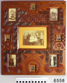
Ann Dale (nee Lees) was given this frame by her younger brother Thomas Chamberlain Lees, who was eighteen at that time. Thomas was the youngest son and seventh child of Lees and Sarah (nee Chamberlain) Lees. Ann loved her little brother’s artistic talents, which are demonstrated in this frame he designed and carefully carved for her. Thomas had cleverly finished the back with timber pieces around the images, and a section of a 1904 calendar. His “GOOD LUCK” is below the image of Ann, her husband Ellis Dale and their five children, c 1900. Sadly, Thomas died in 1911, aged 25. Ellis Dale’s father, William, was a quarryman who sailed from Yorkshire to Australia in 1852. He later bought land for Dale’s Quarries on the edge of Warrnambool in the area of Dale and Aberline roads. From the age of about eleven, Ellis and his brother worked in the quarry beside their father. In 1890 Ellis Dale married Ann Lees. Ann had lived nearby at Wangoom with her parents, Lees and Sarah Lees, who had had her photograph taken when she was a little girl, wearing her black dress. Ellis built a bluestone cottage for himself and Ann on his father’s land in Dales Road. He later added weatherboard rooms, and they named their finished home “Latrigg”. Early in their marriage Ellis recycled some empty dynamite boxes from their quarry to build a cupboard with drawers for Ann’s flat irons and other ironing equipment. The cupboard was used by future generations until recently, when Ann’s granddaughter, Betty Stone, donated it as part of the Chamberlain Dale Lees Collection. It is now in the kitchen of the Port Medical Office. Chamberlain Dale Lees family – local Colonial Pioneers Centre: Ellis Dale and Ann (nee Lees) and their five children - c 1900. Sons lvor William, Robert Ellis, Alfred John, and daughters - Elsie Mary Dale, and Daisy Elvena Dale. Top Left: Ann Lees - c 1868, (the little girl in the black dress) Top Right: William Dale Jnr. and Ellis Dale - c 1871 Lower Left: Ellis Dale and Ann (nee Lees), married 22 Jan. 1890 Lower Right: William Dale Jnr. and Agnes (nee Gillies), married 1883 Oval Photographs: unidentified but presumed to be family members [NB Spelling of Ann Dale – The spelling of Ann’s name has been confirmed by Betty Stone as being “Ann” (Not Anne), by phone conversation with Flagstaff Hill Maritime Village, K P 14th April 2014] (Note: For additional information please refer to Betty Stone’s book “Pioneers and Places - A History of three Warrnambool Pioneering Families” ie. Chamberlain, Dale and Lees Families)This item is associated with the families of Chamberlain, Dale and Lees. These families are listed in the "Pioneers' Register" for Warrnambool Township and Shire, 1835-1900, published by A.I.G.S. Warrnambool Branch. The handmade frame is a unique example of clever craftsmanship and carving skills used by early pioneers with limited access to materials.Family photographs, nine, set into carved, solid wood frame, stained and lacquered. Carving includes leaves, flowers, a horseshoe and a ribbon with the words "GOOD LUCK" Photographs are of the Lees family of Wangoom, from the 'Chamberlain Dale Lees Collection’ Made by Thomas Lees for his sister, Ann. The little girl with black boots on is Betty Stone's grandmother. The back of the frame has a London calendar dated 1904.Words in carved ribbon "GOOD LUCK" Calendar for the year 1904flagstaff hill, warrnambool, shipwrecked coast, flagstaff hill maritime museum, maritime museum, shipwreck coast, flagstaff hill maritime village, great ocean road, chamberlain, dale, lees, stone, betty stone, warrnambool pioneers, thomas lees, wangoom, ann dale, ellis dale, flagstaff hill, warrnambool, shipwrecked coast, flagstaff hill maritime museum, maritime museum, shipwreck coast, flagstaff hill maritime village, great ocean road, chamberlain, dale, lees, stone, betty stone, warrnambool pioneers, thomas lees, wangoom, ann dale, ellis dale, thomas chamberlain lees, handmade photograph frame, carved photograph frame, dynamite -
 Wodonga & District Historical Society Inc
Photograph - Wodonga Civic Buildings Over Time
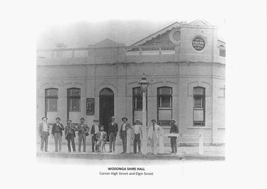
Wodonga Shire was created in 1876 when the colonial government agreed to ratepayers' petitions to have their part of the local government district severed from the Yackandandah Shire to form a new municipality. After meeting for 14 years in rented remises, in the Prince of Wales Hall, Wodonga Council built its first Shire Hall on the corner of High and Elgin Streets in 1890. The date on the façade of the building, 1876, represents the date of the formation of the Shire. In 1957 the second Shire Office was built in Woodland Grove by A.B. and M. A. Chick. These offices were considered more than adequate for future needs. The façade featured floor to ceiling windows and several different meeting rooms in addition to the council chamber, which featured an impressive “horse shoe” table. It also included a kitchen equipped with modern fittings and a President’s room. In the late 1960s the area between Hovell and Havelock Streets as far as Jack Hore Place was zoned for civic purposes. In 1969 plans for a civic centre providing a library, theatre and senior citizens’ rooms. It was opened on 22 April 1971. In 1973, the Council engaged Bruce Marshall to design new offices beside the Civic Centre. Jennings Industries were contracted to complete the offices. The Governor, Sir Henry Winneke, laid the foundation stone of the new offices on 10 March 1976. The Civic Centre was demolished in 2011 to make may for a new $10 million community and entertainment centre which opened in August 2012.These photos are significant because they depict the different buildings which have housed the centre of local government in Wodonga since its inception as an independent shire in 1876.A series of photographs depicting the different buildings used to house the Wodonga Council and Civic buildings over time.wodonga civic buildings, wodonga council, shire of wodonga, rural city of wodonga -
 Stawell Historical Society Inc
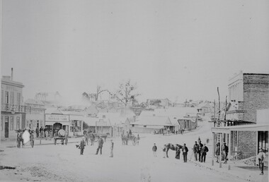
Photograph, Great Western 1866
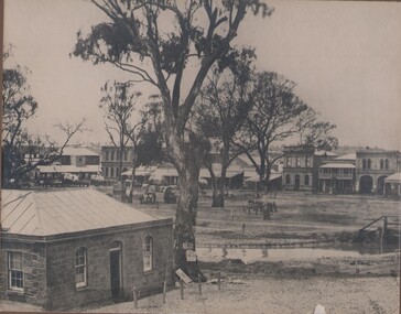
Great Western. Part of a collection of Photographs by Mr. O.G. Armstrong as commissioned by the Shire of Stawell for the Inter-colonial and Paris Exhibition in Melbourne in 1866. Great Western began as a changing station on Concongella, northeast of the present Township. The gold rush in Great Western began in 1858 and soon after a post office and store opened. A Township was surveyed and lots sold in October 1858. The gold soon passed and the diggers went on, leaving a small settlement. In 1863 Jean Pierre Trouette and Emile Bampied, his brother-in-law, planted the first vines and build the first winery, thus setting a firm foundation upon which the present wine industry has been built. Telegraph poles and wires visible. Bakery visible in distance on right of road, looking west. stawell -
 Stawell Historical Society Inc
Photograph, Upper Main Street looking East from Patrick Street corner across Layzell Street 1866
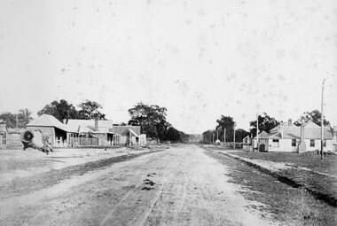
Upper Main Street looking East. Poppet Heads in Background. Oriental Bank second on left then Quartz Reef Timber Yards. Intersection is Layzell St Main Street. Advertiser Office on right in front of Earlier Mechanics Institute. Part of a collection of Photographs by Mr. O.G. Armstrong as commissioned by the Shire of Stawell for the Inter-colonial and Paris Exhibition in Melbourne in 1866. View of the top end of Main Street 1866 with the Commercial Hotel in the left foreground. On the right is the Advertiser Newspaper office an Ararat newspaper before one was started in Stawell. The building on the right with the ladder in front was the Mechanics Institute later burned down twice. Upper Main street with Poppet Heads in the background, the Oriental Bank second on left & then Quartz Reef Timber Yard 1867. Lots of people and wagons in street. Advertiser Office on right and earlier Mechanics Institute with ladder at front.Upper Main Street Reefs 1867stawell mining streetscape -
 Stawell Historical Society Inc
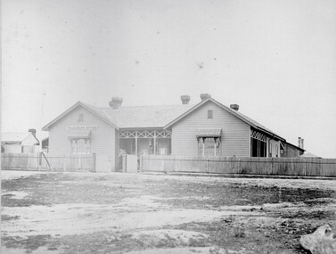
Photograph, Telegraph Office Pleasant Creek Stawell 1866
Telegraph Office Pleasant Creek Stawell. Part of a collection of Photographs by Mr. O.G. Armstrong as commissioned by the Shire of Stawell for the Inter-colonial and Paris Exhibition in Melbourne in 1866. The first post was office was erected at Commercial Street, Pleasant Creek in the goldfields, in June 1858, by J Harding and was a portable one. In October 1860 the first permanent Telegraph Office was erected by Cormick and Irvine for £329. In the same month the Post Office was removed from Commercial St in the Goldfields to the rear of the Telegraph office in Stawell. In February 1862 Edmond Johnson was appointed manager of Electrical Telegraph, Collector of Imposts and acting Postmaster. This building was later used as a private dwelling. It is situated in Lesley Street at the rear of the Pleasant Creek Courthouse although the right-hand wing has been removed. stawell -
 Bendigo Historical Society Inc.
Map - PLAN GENERAL SURVEY MALMSBURY PORCUPINE INN, FOREST CREEK TO GOLDEN POINT. ALEXANDRA RANGE 1853
Colour Copy of Plan of the General Survey from the Town of Malmsbury to the Porcupine Inn, from the sources of Forest Creek to Golden Point, shewing (sic) the Alexandrian Range also Sawpit Gully Bendigo and Bullock Creeks. Handwritten note under the title a follows '' Forwarded to the Colonial Secretary with my letter No A 53/105 dated 30th March 1853 for transmission to the Geological Surveyor. R Hoddle Surveyor General. ' Stamped by Department of Mines Victoria with record#123 in Top right Hand corner. Also contains a catalogue number 2053/M/2. Part of the Contents of a DVD entitled 'Mapping Great Change' - Archival Maps, produced to support an exhibition in the Post Office Gallery Bendigo. A description of the Map, its history and implications for both historical and future discussions is contained in an Essay 'Mapping Great Changes' : The landscape of central Victoria by Gerry Gill.R. Hoddlemap, bendigo, country lands -
 City of Greater Bendigo - Civic Collection
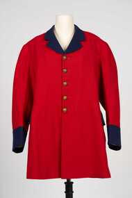
Uniform - Postal Workers Uniform, c. 1890
The post office was situated on site at this Pall Mall location from 1887 until 1997. Early on the building housed a variety of government services included sub treasury, police, water, lands, post and telegraph and quarters for the resident postmaster. With federation in 1901 the building became the Commonwealth Postmaster - General's Department's Bendigo Post Office. In 1975 postal services were taken over by the Australian Postal Commission and in 1989 Australia Post was corporatised.Colonial era postal uniform possibly worn by the Post Master at the Bendigo Post Office. Single breasted frock coat. Scarlet jacket with contrasting royal blue collar, lapel cuffs and pocket flap. Body and skirt section lined with lighter red cotton fabric, pockets lined with cream coloured cotton fabric, sleeves lined with brown, blue and white striped cotton fabric. Five brass buttons on front, two brass buttons on the top of the centre back pleat, each button with a crown and VR. Typically of frock coats of the 19th century the coat has a two distinct sections, a top jacket and skirt. The shoulder seam is bias cut and runs at an angle down the back. The back is cut in four sections and the skirt in two sections. There are no side seams in the coat, instead there is a seam placed further back than the actual side of the wearer.Any possible text on the label on inner top of collar has disappeared.australia post, city of bendigo post office, city of greater bendigo commerce -
 Emerald Museum & Nobelius Heritage Park
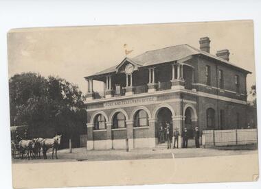
Postcard - Postcard of Parkes Post and Telegraph Office, NSW, 1890s
This postcard is part of an album of postcards which date from late 19th century to mid 20th century. It depicts Parkes Post and Telegraph Office which was built in 1880 and designed by colonial architect, James Barnet and is noteworthy as one of the first 'grand' buildings in Parkes.This postcard is in an album of postcards dating from the late 19th century to mid 20th century. It reflects the popularity of collecting postcards in Australia which reached a height in the early 1900s until around 1920. Postcard of Post and Telegraph Office, Parkes NSW On back left-hand side of card, handwritten: ' "Newthorp" Dec 12 1906 / Wishing you a / Merry Xmas & a / happy New Year / with love from /M (?)Marslock / Parkes PO On back right-hand side of card, handwritten: 'Mr & Mrs W Stuart / Richmond Plains / Wedderburn / Victoria'postcard, photography, 1900s, buildings, parkes, "green postcard album"