Showing 754 items
matching creek view
-
 Eltham District Historical Society Inc
Photograph, Upper Yarra Dam, Spring Tour, 22 Oct 1995, 22/10/1995
EXPLORING THE UPPER YARRA (Newsletter No. 105, November 1995, by Bettina Woodburn) We enjoyed the Spring Excursion, this year "Exploring the Upper Yarra" - in spite of the constant rain and the countryside under the cloud cover, especially in the valleys, being mainly shiny shades of green. The occasional fields of buttercups, clumps of arum lilies and splendid rhododendron and other flowering bushes became very special. The Cobb and Co coach was warm and a cosy retreat as we zig-zagged on the highways and byways to glimpse the Yarra River, upstream and down, its secret places, and particularly the many bridges. Russell excelled as 'Poet Laureate', reading from Dacre Smyth's book. This 1979 publication includes paintings of all the bridges along the river with poems and brief descriptions of each one. Some of the bridges are in out of the way places and are not very well known. We looked forward to hearing the poetry as much as seeing the ' constructions'…Big Pat (was he short or tall, lean or fat? He did win the two hundred pound reward for discovering gold and had the creek named after him), about the 'Eddies'?, and the disliked 'meccano' bridge in Warburton, etc. etc. The hot roast lunch in the old Reefton Hotel was also most welcome. It was easy to imagine it peopled by miners and early settlers. Starting by crossing the new (1974) concrete bridge at Warrandyte we headed through Wonga Park with views to the Christmas Hills and to the escarpment of the Yering Gorge, which causes flood waters to back up through the Yarra Glen plain, so avoiding disasters downstream. At the end of a long driveway we found the wooden, privately owned Henley Bridge (1935 after the 1934 floods). This facilitates access to different parts of Henley Farm and to Lilydale. Everard Park, named after Blanche Shallard's father, a State Member for 17 years, below the Highway Yarra crossing was in need of care. It is 10 miles from Yarra Glen by road but, as "Yarra Marra” canoeists well know, 32 winding miles down by water. After more delightful countryside scenes we joined the Warburton Highway at Woori Yallock. From the old Railway Station at Launching Place the Centennial Trail for walkers, cyclists and ' horse riders has replaced the rails. The line from Lilydale was opened in 1901, and the last diesel freight train ran to Warburton in 1965. It continued to rain as we had morning tea in Warburton in a shelter between footbridges. From here we continued upstream past the Bridge to O'Shannasy Lodge and Reservoir, Starvation Creek, and the Peninsular tunnel (miners dug it as at Pound Bend) which we visited (scrambling down those steps!) on our return after lunch. Our furthermost point was the Upper Yarra Dam Reserve (and vast catchment area). Finished in 1957 after ten years work and 100 years after Yan Yean, it supplies much of Melbourne's water. After crossing the 30m Launching Place Bridge to the Eltham side of the Yarra and Healesville, we saw in the distance the Yarra Glen Timber Trestle Bridge over the river flats "the longest for years in the land it was said!" Harry's dream of "better weather over the Divide" unfortunately didn't come true, but I'm sure we 36 members will retain happy memories of a day that was wet and green and filled with Bridges. Bettina Woodburn - October 1995 Record of the Society's history of activities - Spring 1995 excursionColour photographshire of eltham historical society, activities, upper yarra dam, henley bridge -
 Eltham District Historical Society Inc
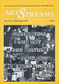
Journal, Peter Doughtery, ArtStreams: Arts & Culture in Banyule, Darebin, Manningham, Nillumbik and Whittlesea; Vol. 5, No. 1, Mar-Apr 2000, 2000
Vol. 5, No. 1, Mar-Apr 2000 CONTENTS ON THE ROAD The Car at Heide 3 ON TOP OF THE WORLD Dandenong Ranges Folk Festival 5 INTERVIEW Felicity Gordon 7 SOUNDS OF HARMONY Gyuto Monks in Eltham 10 BANYULE FESTIVAL 13 WERE ST HILL CLIMB 15 BOROONDARA WRITERS' FESTIVAL 16 WARRANDYTE VILLAGE FESTIVAL 18 DIAMOND CREEK TOWN FAIR 19 TEMPLESTOWE VILLAGE FESTIVAL 20 RECIPES From leading Chefs 21 CAIRO TO CRACOW Middle Eastern Music at Montsalvat 22 POETRY 23 FESTIVAL OF KITES 24 BOOK REVIEW By Michele Lonsdale 25 CD REVIEWS 27 ARTIN ABOUT 28 WINING & DINING 30 ARTISTS SERVICES 32 "Peter Dougherty has been involved in the local art scene for many years. As publisher and editor of the arts magazine Artstreams, his comments on the various branches of the arts are widely respected. His "The Arts" column in the Diamond Valley Leader presents a brief summary for a much wider cross section of the local community. Peter also operates his own gallery and the Artstreams Cafe at the St Andrews market. Peter has a wealth of knowledge about present day and historical aspects of local art and artists." - Eltham District Historical Society Newsletter No. 161, March 2005Colour front and back cover with feature articles and literary pieces with photographs and advertisements printed in black and white. 36 pages, 30 cm. Vol. 1, no. 1 (Nov. 1996) - Vol. 10, no. 5 (summer ed. 2005/06) art streams, carly young, plenty views golf park, dynamic vegies, dandenong ranges folk festival, felicity gordon, sounds of global harmony, banyule festival, rosanna fire station community house, bulleen art & garden centre, were street cafe, were street hill climb, bahnhof cafe, walkers wheels, peter glass, eltham wiregrass gallery, boroondara writers festival, warrandyte festival, diamond creek town fair, templestowe village festival, willy wonkas ice cream, gourmet food, ciaro to cracow, fleur de feliss florist, mia mia gallery, festival of kites, bi-wize quality paints, kinglake gallery, andy cowan, wild dog hill studio, montsalvalt, ian collard, geoff achison, bridget allen, thompsons pharmacy, volumes -
 Eltham District Historical Society Inc
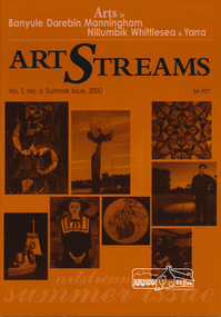
Journal, Peter Doughtery, ArtStreams: Arts in Banyule, Darebin, Manningham, Nillumbik, Whittlesea & Yarra; Vol. 5, No. 6 (sic - 5), Summer Issue 2000, 2000
Vol. 5, No. 6 (5), Summer Issue 2000 CONTENTS John Perceval and Helen Daniel 2 Two who served their communities well Gateway Sculpture Project 3 New public art in Manningham The Artary Project 5 Getting onto the net Tucker: Australian Gothic 6 Albert and Barbara Tucker's gift to Australia Short Story 8 Learning Curves Interview 10 Elizabeth James on drawing Open Studios 12 40 artists welcome the public Banyule Youth Awards 18 Support for emerging young artists Not Just a Pretty Place 20 Nillumbik art in Public Places CD Reviews 22 Book Reviews 23 Australian Classical Music 24 Elizabeth Scarlett Theatre Reviews 25 Artin About 26 Wining & Dining 30 Book Review 32 Artist's Services 32 "Peter Dougherty has been involved in the local art scene for many years. As publisher and editor of the arts magazine Artstreams, his comments on the various branches of the arts are widely respected. His "The Arts" column in the Diamond Valley Leader presents a brief summary for a much wider cross section of the local community. Peter also operates his own gallery and the Artstreams Cafe at the St Andrews market. Peter has a wealth of knowledge about present day and historical aspects of local art and artists." - Eltham District Historical Society Newsletter No. 161, March 2005Colour front and back cover with feature articles and literary pieces with photographs and advertisements printed in black and white. 36 pages, 30 cm. Vol. 1, no. 1 (Nov. 1996) - Vol. 10, no. 5 (summer ed. 2005/06) art streams, public art, sentinal, river peel, manningham, artary project, plenty views golf park, albert tucker, barbara tucker, kinglake gallery, bulleen art & garden centre, st andrews gallery, steve flanagan, eltham wiregrass gallery, elizabeth james, willy wonka's ice cream gourmet food, nillumbik artists' open studios, accadia ceramics, alan martin, alan sartori, attunga, veronica holland, leanne mooney, sally nihill, bend of islands, michael skewes, elizabeth vercoe, creek house studio, syd tunn, ona henderson, chris pittard, mary lou pittard, diamond creek living & learning centre, drew gregory, jane annois, jane trikojus, jenni mitchell, grace mitchell, mervyn hannan, girraeen studio, jill forrest, kangaroo studios, peter burns, jules burns, muddy waters studio, nel ten wolde, overbank end, kay steventon, kim tarpey, reg cox, robert phillips studio, stained glass studio, shan shnookal, matthew holderness, ray macminn, jane viola, john hewish, open pottery studios, linda detoma, judith roberts, cassandra tobias, christian benetto, kevina-jo smith, julianne piko, hugh crosthwaite, sarah slater, peter doyle, stuart sinclair, carly young, lenister farm, not just a pretty place, kangaroo house, dynamic vegies, old bakery cottage bookshop, nick charles, felicity nottingham, michael mcgirr, eltham little theatre, heidelberg theartre company, montsalvat, recherche, ken eckerall, thompsons pharmacy, st andrews market, 2000 banyule young artists award, heide museum of modern art -
 Eltham District Historical Society Inc
Film - Video (Digital), Geoff Paine, St Margaret's Church, Eltham: Stories of the Nillumbik Shire with Geoff Paine, June 2020
One of a series of videos "Stories from the Nillumbik Shire with Geoff Paine" Geoff Sandy, Parish Historian and Archivist gives a history of the church which was opened 12 December 1861. It is constructed of polychrome bricks (lots of different colours). References a long relationship of over 159 years between the church committee and the Eltham Hotel across the road for refeshments for church events. The land was donated by Henry Dendy, the founder of Brighton where he lived for five years before going bankrupt and moving to Eltham where he bought a steam powered flour mill on the banks of the Diamond Creek at the end of Pitt Street. The church is heritage protected as well as the 1870 parsonage, Dendy House. It was always meant to be a much bigger church and extended along the north wall. This was finally achieved in 2014. Shows views inside of the original section and the extension. Also discusses the original tall windows on the south with gold trimming and other windows with gold trimming. Some original windows have been replaced by stained glass. Discussion about the Patron Saint of the Church, Margaret of Scotland. The original window made for £1 by Yuri and Fergusson in Melbourne and possibly one of the first made in the Colony of Victoria was relocated to the north wall during the 2014 extension. The crucifix was made by Matcham Skipper. Also features the Honour Roll. The walls of the extension are mudbrick, timber from a variety of sources and very much in keeping of the character of Eltham. The bell and bell tower are original. At the end of the First World War the bell was rung so vigorously that the bell broke.MP4 Digital file 00:05:48; 672MBvideo recording, church bell, dendy house, eltham, eltham hotel, flour mill, geoff sandy, henry dendy, honour roll, matcham skipper, mudbrick construction, pitt street, st margaret's anglican church, stained glass -
 Eltham District Historical Society Inc
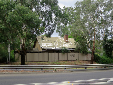
Photograph, Jim Connor, Main Road, Eltham, 14 Jan 2017
Eltham Gateway, View of 43 Antoinette Boulevard from Main Road at the approaches of the Main Road Bridge over the Diamond CreekTomorrow's history documented todayeltham, jim connor collection, main road, eltham gateway -
 Eltham District Historical Society Inc
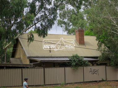
Photograph, Jim Connor, Main Road, Eltham, 14 Jan 2017
Eltham Gateway, View of 43 Antoinette Boulevard from Main Road at the approaches of the Main Road Bridge over the Diamond CreekTomorrow's history documented todayeltham, jim connor collection, main road, eltham gateway -
 Eltham District Historical Society Inc
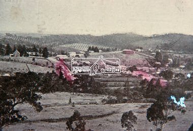
Slide, View overlooking Diamond Creek, 1907
... View overlooking Diamond Creek...View overlooking Diamond Creek to the northeast, most... melbourne View overlooking Diamond Creek to the northeast, most ...View overlooking Diamond Creek to the northeast, most likely from near St John's Church, 190735 mm colour positive transparency of a newsprint image taken c.1970 Mount - Kodak Kodachrome Card13diamond creek township -
 Eltham District Historical Society Inc
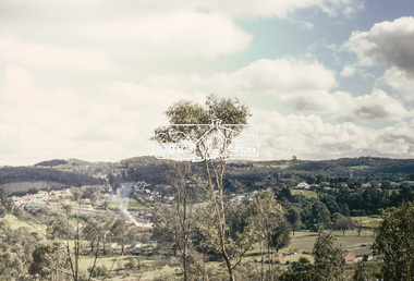
Slide, View overlooking Diamond Creek, 1970
... View overlooking Diamond Creek...View overlooking Diamond Creek to the northeast, most... melbourne View overlooking Diamond Creek to the northeast, most ...View overlooking Diamond Creek to the northeast, most likely from near St John's Church, 197035 mm colour positive transparency of a newsprint image taken c.1970 Mount - Kodak Kodachrome Card27diamond creek township -
 Eltham District Historical Society Inc
Slide, Construction of Eltham Town Park, 22 Feb 1974
Construction of Eltham Town Park, later renamed Alistair Knox Park. View looking towards Bridge Street and shows the Diamond Creek and formation of the Diamond Creek Trail.35 mm colour positive transparency Mount - Agfacolor Service (Blue)alistair knox park, eltham town park, bridge street bridge, diamond creek -
 Eltham District Historical Society Inc
Slide - Photograph, Eltham Town Park, c.May 1988
In 1981 the Shire of Eltham Historical Society was asked by the Victorian Place Names Committee to comment on a proposal by the Shire of Eltham to assign names to parklands in Eltham as follows:- "Eltham Common" - the area between the municipal offices, Main Road, the Eltham railway -line, and Panther Place and containing Shillinglaw Cottage. The Shire has advised that this name has been used locally for the site since about 1975. "Alistair Knox Park" - the area bounded by the Eltham railway -line, Panther Place, Main Road, Bridge Street, and Susan Street, and through which flows the Diamond Creek. The area has been known locally as "Eltham Town Park" The proposed name "Alistair Knox Park" had created some local controversy with a number of reversals of the Council's decision and letters to the local paper both for and against the proposal. The society was reluctant to be drawn into this controversy particularly as there were known to be members with strong views both for and against the proposed name. The society appreciated the work done by Alistair Knox both in the formulation of the park concept and in its development but because of the controversy generated by the proposed naming and also because of the wide general use of the park by the public·, the name Eltham Town Park was felt more appropriate. The society noted that there was no outstanding historical associations with the land comprising the park which would warrant naming the park after any particular person, place or event. No objection was raised to the Eltham Common proposal as set-out above. The decision was made in the knowledge that Alistair Knox had been associated with the society over many years and was a prominent figure in the recent history of Eltham. He was regarded as a key figure in the environmental building movement and in particular was renowned for his use of mud bricks as a building material. He served as a councillor of the Shire of Eltham from 1971-1975, his final year as Shire President. It was during these years that the proposals to create the park in its present form were shaped and Alistair played a leading part in the decision to make it a landscaped passive recreational park rather than a sporting area. The parklands comprise a section of the Diamond Creek valley. The creek itself flows through the centre of the area which is overlooked by steep hills on each side. The parks form part of the land purchased from the Crown in 1851 by J.M. Holloway and then subdivided into allotments and called "Little Eltham". While most of the area was subdivided into residential lots the creek valley was subdivided into lots suitable for small farms. Some further subdivision took place over the years and the whole of the parks now comprises eight separate titles. A list of some of the former owners has been compiled but exhaustive research on all owners has not been carried out. The ownership of one parcel has been traced back to when it was purchased from Holloway by John Hicks Petty in 1874, long after it was subdivided. Other families owning land within the area over the years included Lyon, Rees, Clark, Waterfall, Carrucan, Graham, Hill and Morant. The character of the valley area has remained rural while development occurred on each side. Early photos show the area as orchard and grazing land. In 1901 the railway was constructed through the area resulting in the timber trestle bridge across the Diamond Creek. which is an important feature of the park landscape. A memorial obelisk to the Eltham servicemen killed in World War 1 was erected at the south eastern corner of the park. The site is now within the intersection of Main Road and Bridge Street and the memorial was shifted in the 1950s to the Eltham R.S.L. clubrooms. Following the financial failure of the local sub-branch, the memorial obelisk was again relocated to the Eltham War Memorial building precinct in 2011. During the early 1960's the Council started purchasing the land which now comprises the parks. In the late 1960's the area to the east of the Diamond Creek was used as a garbage tip and filled above the flood plain of the creek. When this area was filled the tip was transferred to the west side of the creek. From the early 1970's the area has been progressively developed as a park for passive recreation with ornamental lakes, extensive tree planting and landscaping. The character of the valley before the days of the tip has been recreated and this has earned a Landscape classification from the National Trust, an unusual honour for a man-made landscape. The parks are not only attractive in appearance. The large number of people using them, particularly at weekends and holidays is evidence of their popularity and the foresight and careful planning of local residents, Councillors and Council Staff. 35mm colour positive transparency (1 of 23) Mount - Kodak EktachromeProcess Date MAY 88Meltham, main road, alistair knox park, eltham town park -
 Eltham District Historical Society Inc
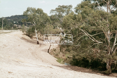
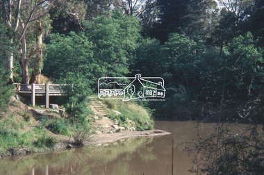
Slide - Photograph, Viewing platform near the confluence of Diamond Creek and Yarra River, c.Nov. 2001
Part of a slide show presentation "A Trip Down the Diamond Creek" by Russell Yeoman to the Eltham District Historical Society meeting of 14 Nov. 200135mm colour positive transparency Mount - Black and Whiteconfluence, diamond creek, yarra river -
 Eltham District Historical Society Inc
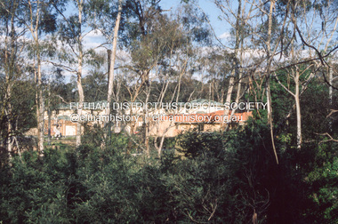
Slide - Photograph, Development either side of Railway Road viewed from across Railway Parade, Eltham, c.Nov. 2001
Part of a slide show presentation "A Trip Down the Diamond Creek" by Russell Yeoman to the Eltham District Historical Society meeting of 14 Nov. 200135mm colour positive transparency Mount - Black and Whiteeltham north, housing estate, railway parade, railway road, eltham -
 Eltham District Historical Society Inc
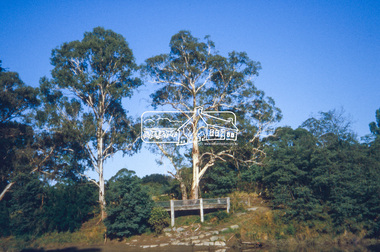
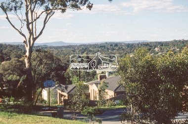
Slide - Photograph, Northeast view from near 68 Porter Street, Eltham, c.Nov. 2001
Part of a slide show presentation "A Trip Down the Diamond Creek" by Russell Yeoman to the Eltham District Historical Society meeting of 14 Nov. 200135mm colour positive transparency Mount - Black and Whiteeltham, porter street -
 Eltham District Historical Society Inc
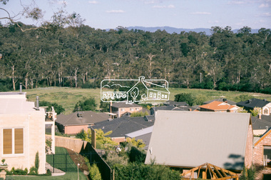
Slide - Photograph, Southeast view from near 60 Porter Street, Eltham, c.Nov. 2001
Part of a slide show presentation "A Trip Down the Diamond Creek" by Russell Yeoman to the Eltham District Historical Society meeting of 14 Nov. 200135mm colour positive transparency Mount - Black and Whiteeltham, porter street -
 Eltham District Historical Society Inc
Work on paper (Sub-Item) - Photograph, The Kinglake escarpment. View from Bald Spur lookout across Arthurs Creek to Mount Sugarloaf, 1980
kinglake, blad spur, arthurs creek, mount sugarloaf -
 Eltham District Historical Society Inc
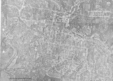
Work on paper (Sub-Item) - Aerial Photograph, Diamond Creek from Yarra River to Wattletree Road, Eltham
Black and white aerial photograph witrh key features around the central place of Eltham township marked inluding Yarra River, Main Road, Bridge Street and Ryans Road, Eltham North land development, real estate, aerial view, eltham, eltham north -
 Eltham District Historical Society Inc
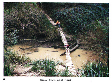
Work on paper (Sub-Item) - Photograph, Home-made footbridge across Diamond Creek, opposite Gum Glade, Eltham
Colour photograph of home-made footbridge across the Diamond Creek opposite Gum Glade, Eltham. View from east bank.eltham, diamond creek, footbridge, gum glade -
 Eltham District Historical Society Inc
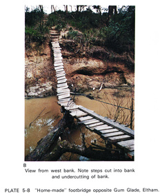
Work on paper (Sub-Item) - Photograph, Home-made footbridge across Diamond Creek, opposite Gum Glade, Eltham
Colour photograph of home-made footbridge across the Diamond Creek opposite Gum Glade, Eltham. View from west bank. Note steps cut into bank and undercutting of bankeltham, diamond creek, footbridge, gum glade, creek bank -
 Eltham District Historical Society Inc
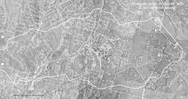
Work on paper (Sub-Item) - Photograph, St Helena East, St Helena West and Eltham West drains, ca 1980
black and white aerial photograph with boundary and drains marked over three page fold out eltham, st helena, drains, aerial view -
 Eltham District Historical Society Inc
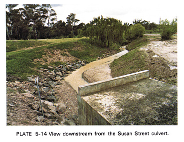
Work on paper (Sub-Item) - Photograph, View downstream from the Susan Street culvert
... melbourne Colour photograph of the view downstream from the Susan ...Colour photograph of the view downstream from the Susan Street culvert, Elthameltham, susan street, culvert, drain, channel -
 Eltham District Historical Society Inc
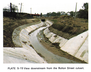
Work on paper (Sub-Item) - Photograph, View downstream from the Bolton Street culvert
... melbourne Colour photograph of the view downstream from the Bolton ...Colour photograph of the view downstream from the Bolton Street culvert, Elthameltham, channel, concrete, drain, bolton street -
 Eltham District Historical Society Inc
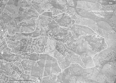
Work on paper (Sub-Item) - Photograph, Research Creek
... view Research Creek Image printed on A4 page from 04997 Diamond ...Black and White aerial photograph of Research witht the Research Creek and Main Road highlighted.eltham, research, aerial view, research creek -
 Eltham District Historical Society Inc
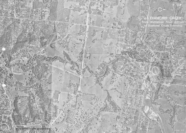
Work on paper (Sub-Item) - Photograph, Diamond Creek from Wattletree Road, Eltham to Diamond Creek township
... Black and white aerial view of Diamond Creek from... melbourne Black and white aerial view of Diamond Creek from ...Black and white aerial view of Diamond Creek from Wattletree Road, Eltham to Diamond Creek Townshipeltham, drain, diamond creek -
 Eltham District Historical Society Inc
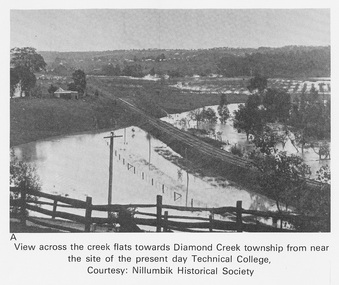
Work on paper (Sub-Item) - Photograph, View across the creek flats towards Diamond Creek township
... View across the creek flats towards Diamond Creek township...Undated black and white photograph of view across the creek... 04997 Diamond Creek Basin Study, 1980 View across the creek ...Undated black and white photograph of view across the creek flats towards Diamond Creek township showing the railway line, with the Diamond Creek under flood. Situated behind the vicinity of Diamond Valley College, Main Hurstbridge Road, Diamond Creek. Diamond Valley College was formed in 1989 from the almagamation of Diamond Creek Technical School and Hurstbridge High School. Nillumbik Historical Society collectionflood, diamond creek, nillumbik historical society -
 Eltham District Historical Society Inc
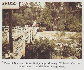
Work on paper (Sub-Item) - Photograph, Flooding, View of Diamond Street Bridge, Eltham 8 April 1977
Colour photograph. Flooding of Diamond Creek at Diamond Street Eltham bridge approximately 2 1/2 hours after the flood peak. Note debris on the bridge deck. 8 April 1977. flood, diamond creek, flooding, eltham, diamond street, bridge -
 Eltham District Historical Society Inc
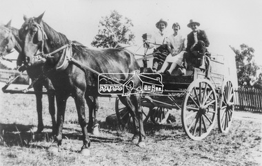
Photograph, View of two men wearing hats with a young woman seated in between on a cart harnessed to two horses, possibly Diamond Creek and Hurstbridge district, c.1920
Black and white copy of photo printed on glossy photographic paper 30.5 x 40.5 cm (12 x 16 inch); image size approx. 18.5 x 28 cmdiamond creek, groups, horse, horse drawn carriage, hurstbridge -
 Eltham District Historical Society Inc
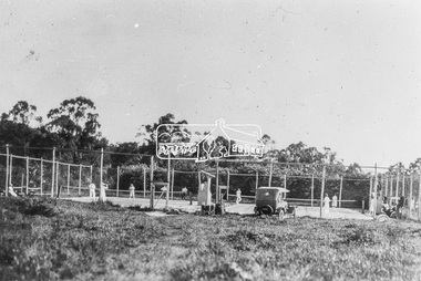
Photograph, Diamond Creek Tennis Club, Diamond Street, Diamond Creek, c.1926
New tennis courts on Diamond Street, Diamond Creek. The car belongs to Dr. E. Cordner Senior who was a keen tennis and football player. The courts were originally located at a site below Fyffe Street but were demolished when railway construction began in 1911. - Yarra Plenty Regional Library (via Picture Victoria) http://www.picturevictoria.vic.gov.au/site/nillumbik/NillumbikLocalHistoryDigitisationProject/6918.html The official opening of the Diamond Creek Tennis Club was on Saturday, December 2nd, 1922 where Dr. E. R./ Cordner (President) presided. 1922 'Diamond Creek.', Advertiser (Hurstbridge, Vic. : 1922 - 1939), 8 December, p. 2. (AFTERNOON), viewed 16 Feb 2020, http://nla.gov.au/nla.news-article56637465 The car belonging to Dr Cordner is a Ford Model T. The first Australian made Model T came off the production line in Geelong, 1 July, 1925. Black and white copy of photo printed on glossy photographic paper 30.5 x 40.5 cm (12 x 16 inch); image size approx. 18.5 x 28 cmcar, diamond creek, diamond creek tennis club, diamond street, dr edward rae cordner snr, ford model t, motor vehicles -
 Eltham District Historical Society Inc
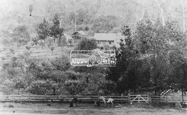
Photograph, Elevated view of farmhouse and buildings, possibly Diamond Creek and Hurstbridge district, c.1900
Black and white copy of photo printed on glossy photographic paper 30.5 x 40.5 cm (12 x 16 inch); image size approx. 18.5 x 28 cmdiamond creek, farm-buildings, fences, horse, hurstbridge -
 Eltham District Historical Society Inc
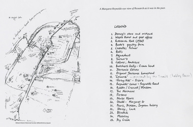
Document - Map, Margaret Reynolds, A Margaret Reynolds-eye view of Reseach as it was in the past, 1989
Reproduced in Return to Research : a centenary history of Research Primary School / edited by Andrew LemonA4 photocopy andrews, bell, blashik, bode's poultry farm, butchers gully, cassells, collins, concord, creswell, dickson, doney's store, dry creek, ferny hill, gadd, ingram bakery, lack, margaret reynolds, margaret street, maroondah aqueduct, masson, moseley, normans, nurse moore, palmer, parsons, peers, prior, research (vic.), research hall, reynolds corner, reynolds road, rodda, storey, traill property, turner, west's hotel, yarramie estate