Showing 3431 items
matching distance
-
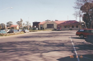
 City of Kingston
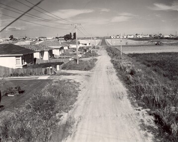
Photograph - Black and white, c. 1960
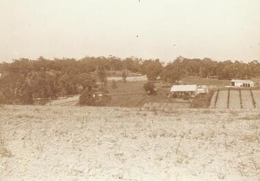
This image depicts a scene of East Bentleigh in 1960, viewed along Thomasina Street as it crosses Gladwyn Street towards East Boundary Road in the distance. The gardens and new homes are well-tended, but the street surfacing is unsealed.Developing urban area now located within the City of Glen Eira, formally City of Moorabbin. This image illustrates the mid century urban sprawl of new suburbs and the subdivision of market gardens within the municipality and the changing demographic of the district as new houses are constructed and infrastructure established. Black and white photograph of unsealed road in new development in the area of Moorabbin, new houses appear on the lefthand side with paddocks on right side of image with installation of electric poles. Sealed road in the distance. Thomasina Street, as it crosses Gladwyn Street, East Bentleigh towards East Boundary Road. Handwritten in blue ink: 60 - 373 D Handwritten in red ink: 80% Handwritten in black ink: Ch. 6bentleigh, east bentleigh, market garden, housing, suburbs, infrastructure, moorabbin -
 Stawell Historical Society Inc
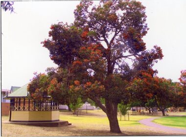
Photograph, Cato Park Flame Tree playground c 1995 -- 2 Photos -- Coloured
2 Colour Photos Gateway, Flame Tree and Playground in Cato lake c 1985. This area was once the gateway to Cato lake but later moved. Both photos are near the lake as can be seen in 67.18a which has a view of the playground in the distance.Two colour photographs, one of the Gateway flame tree. the other a view of the edge of the lake with the playground in the distance. The flame tree in 67.18 shows the flame tree in flower beside the rotunda. The other photo 67.8a is a view of the edge of Cato lake with the playground in the background behind a group of trees. stawell -
 Port Fairy Historical Society Museum and Archives
Photograph
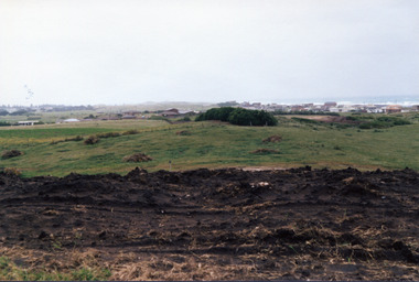
South Beach Developement Coloured photograph of Earthworks in foreground with a tree shelter belt in middle distance and South Beach Estate in distancesouth beach, development, road making, street -
 Stawell Historical Society Inc
Painting, Nancy Rutter, "The Old Gum Tree" Painting by Nancy Rutter
Nancy Rutter Local ArtistArtists Card Australian landscape with Hills in Distance Two mid distance broke dead branch in left foregroundNancy Rutter The old Gum Tree Oil. on Rear of Painting along with information on Card Maker,australian landscape -
 Phillip Island and District Historical Society Inc.
Photograph - Post Card, Early 20th Century
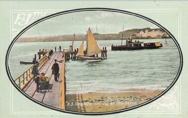
A Collection of postcards showing different views around Phillip Island. 10 of a collection of 11 postcards donated by M. Trott. Photo 1. S.S. Genista coming into Newhaven pier with another boat and people at the pier. Photo 2. The Granite Quarry at Cape Woolamai. Photo 3. View of the Newhaven pier with San Remo in the distance Photo 4. Milking Time, Newhaven. Photo 5. Wool Team on road to Cowes. Photo 6. View of the Cowes Jetty and Cowes in the background taken from a Steamer. Photo 7. View of Back Beach near The Nobbies. Photo 8. Cowes Jetty and Jetty Shed with Govt Steamer "Lady Loch" in the distance. Photo 9. Cape Woolamai coastline. Photo 10. Fisherman's Hut, Cowes with Jetty and boats in the background. 1. "S. S. Genista" calling at Newhaven. Phillip Island. 2. Phillip Island Granite Quarry, Cape Woollami 3. Phillip Island. Newhaven, San Remo in distance. 4. Phillip Island - Milking Time, Newhaven. 5. Phillip Island - Wool Team on road to Cowes. 6. Phillip Island - Cowes from Steamer. 7. Phillip Island - Back Beach. 8. Phillip Island - Cowes Jetty. Govt Steamer "Lady Loch" in distance. 9. Phillip Island - Cape Woollami. Home of Mutton Bird. 10. Phillip Island - Fisherman's Hut, Cowes.cowes jetty, newhaven jetty, granite quarry cape woolamai, phillip island coastline, fisherman's hut cowes, ss genista, lady loch steamer, m trott -
 Stawell Historical Society Inc
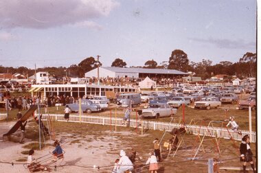
Slide, Ian McCann, Stawell Show
Children playing on playground eqipment in foreground with car park in mid distance, crowd in far disatance and to the left mid distance.stawell show -
 Bendigo Military Museum
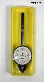
Equipment - MAP MEASURER/OPISMETER, DEPOSE
Vintage opisometer used for measuring distances on maps. Part of the Kevin John Herdman, No. 397661, Collection. See Catalogue No. 5942P for details of his service record..1) Circular chromed metal instrument with handle. Calibrated dial with black markings and hand on a white background. Reverse face has unit conversion details in black text on white background. Each face is covered with a convex glass lens. On the opposite end to the handle is a small wheel with milled edge. As it turns, the hand on the front dial turns to measure distance. .2) Rigid plastic rectangular storage case in two parts. Base is yellow, top is clear..1) Printed on front dial: 'INCHES, MADE IN FRANCE'. Printed on back dial: 'Unit conversion details'. Stamped on metal near wheel: 'DEPOSE, H(logo)B'. .2) Stamped on clear cover: 'CURVIMETRE, MAP MEASURER, H(logo)B, MADE IN FRANCE'.map, map measure, equipment, opisometer, kevin john herdman -
 Clunes Museum
Photograph
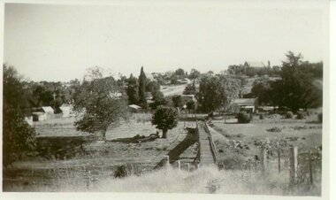
VIEW OF SUSPENSION BRIDGE WITH TOWNSHIP IN THE DISTANCEsuspension bridge, local history -
 Port Fairy Historical Society Museum and Archives
Photograph
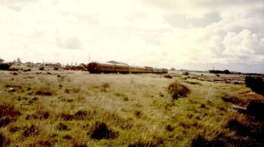
Last Train Leaving Port Fairy 10.09.1977Coloured Photograph of train moving into the distance transport, rail, road, train, last train -
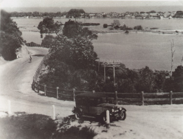 Lakes Entrance Historical Society
Photograph - Princes Highway around Jemmys Point, Lakes Entrance, H D Bulmer, 1930 c
Princes Highway around Jemmys Point, car parked on road at junction of original steep road to top of Jemmys Point. Man on bicycle riding up hill. Bullock Island and New Works in distance over North Arm and Cunninghame Arm waterways Lakes Entrance VictoriaBlack and white photograph of lower section of Princes Highway around Jemmys Point, car parked on road at junction of original steep road to top of Jemmys Point. Man on bicycle riding up hill. Bullock Island and New Works in distance over North Arm and Cunninghame Arm waterways Lakes Entrance Victoriaroads and streets, township, waterways, fences, vehicles -
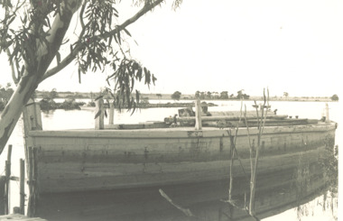 Lakes Entrance Historical Society
Photograph, Lady Harriet Barge, Lakes EntranceVictoria, 1988
Photograph taken after barge was purchased from Elliott family before being towed to Lakes Entrance for Entrance Centenary celebrations. , small jetty bottom left hand corner, Silt jetties with Jones Bay in distance limb of gum tree could be on the Mitchell River near Bairnsdale Gippsland Lakes VictoriaBlack and white photograph of Lady Harriets barge moored with mast removed and lying on deck, small jetty bottom left hand corner, Silt jetties with Jones Bay in distance limb of gum tree overhanging top left corner could be on the Mitchell River near Bairnsdale Gippsland Lakes Victoriabusinesses, barges, boats and boating -
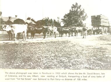 Port Fairy Historical Society Museum and Archives
Newspaper - Newspaper article
This photo was taken in Penshurst in 1903 which shows the late David Brown, late of Colerain Balmoral and his son, Albert, now residing at Gritjurk, transporting a load of sixty bales of wool from “Yat Nat Estate” near Balmoral to Port Fairy —a distance of 108 miles.Black and white photograph from a newspaper article with a large wool laden wagon with 14 bullocks yoked up The above photo was taken in Penshurst in 1903 which shows the late David Brown, late of Colerain Balmoral and his son, Albert, now residing at Gritjurk, transporting a load of sixty bales of wool from “Yat Nat Estate” near Balmoral to Port Fairy —a distance of 108 miles.transport, rail, road, bullocks, wagon, carrier, penshurst, balmoral, albert brown, david brown, wool bales, yat nat estate, gritjurk -
 University of Melbourne, Burnley Campus Archives
Photograph - Sepia print, A.E. Bennett, Entrance Gates, 1894-1990
Note by E.B. Littlejohn, "Is the roadway the original Swan Street? Entrance gates to Gardens in the distance. Roadway leading to the Pavilion hidden behind the trees. No elms showing along the roadway," and by T.H. Kneen, "The roadway appears to terminate at the gates outside the Curator's Residence, sweeping past the Pavilion on the right. I have seen a plan which showed an attractive avenue of trees (pine) from the western end of the property (where the Stockman's Cottage was later sited.)" 2 copies sepia photograph. Copy of sepia photograph of the roadway to the Entrance Gates and Curator's Cottage seen in the distance, with the Pavilion on the right, in, "Prize Essays," Alfred E. Bennett, c.1894, after p 116. Pinus radiata avenue on each side of the road.entrance gates, prize essays, alfred e. bennett, curator's residence, pavilion, stockman's cottage, pine tree avenue -
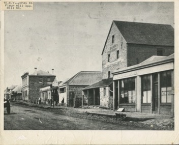 Kilmore Historical Society
Photograph, SW Sydeny Street, 1860
25cm x 20 cm black and white photograph mounted on board. The photograph is taken at an angle so you can see multiple buildings on the western side of Sydney Street including: Trainor's Steam Flour Mill, Parnells Boot Shop, Quinn Solicitor, Youngs Bakery and Post Office and Royal Oak Hotel in the distance.Written on the back: #10 Trainor's Steam Flour Mill, Parnell's Bootshop, Quinn Solicitor, Young's Bakery + Post Office #3.#5.10/86-38A Copy of Sydney St. Kilmore 1860 Trainors Mill (opposite present Mill St) Royal Oak Hotel in distance.post office, flour mill, bakery, bootmaker -
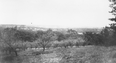 Ringwood and District Historical Society
Photograph, Overlooking Heathmont from Pump's orchard - 1926
Black and white photograph of orchard. Housing in distance.Typed below photograph, "Overlooking Heathmont from Pump's orchard, 1926". -
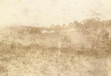 Ringwood and District Historical Society
Photograph, "Quambee", North Ringwood, 1912 - viewed from Coombes' property
Sepia photograph showing the house and buildings in the distance.Written on rear of photograph: "Quambee, North Ringwood, 1912 - from Coombes' property." Quambee was owned by Augustus Temple Miles until 1916. -
 Ringwood and District Historical Society
Photograph, "Quambee", North Ringwood - 1913
Sepia photograph showing house and outbuildings in the distance. -
 Phillip Island and District Historical Society Inc.
Photograph - Post Card, Early 1900's
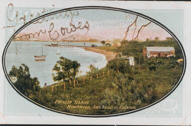
One of 16 photographs and postcards donated by Mary KarneyColour postcard of Newhaven with pier and San Remo in the background."Greetings from Cowes" "Phillip Island Newhaven, San Remo in distance."newhaven jetty, newhaven beach, phillip island beaches, mary karney -
 Phillip Island and District Historical Society Inc.
Photograph, Early 20th Century
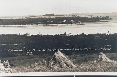
One of 20 photographs/postcards donated by Mary KarneyBlack & White copy of postcard. View taken from San Remo overlooking township across the water to Newhaven, with Churchill Island and Rhyll in the background."Overlooking San Remo, Newhaven, Churchill Island; Rhyll in the distance. 285"san remo, newhaven phillip island, churchill island, rhyll phillip island, mary karney -
 Orbost & District Historical Society
black and white photograph, first half 20th century
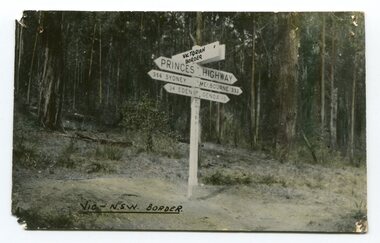
Prior to the sealing of the Princes Highway west of Orbost, the road surface was anything but good, even by C1917 when cars started to use the road. From Orbost the old road via Marlo to Sydenham was abandoned for the new location which traversed more rugged country via Cabbage Tree, Bell Bird and Club Terrace to Cann River, and the reason for this diversion was on account of settlements being established at Murrungowar and Club Terrace, at which latter place there was a temporary rush to obtain gold. This road was constructed by the Public Works department and a maximum grade of 1 in 19 was adopted, and as speed was not to be catered for the grade followed in and out round the spurs and gullies, resulting in a maze of turns and twists which required a good deal of skill on the part of the horse driver to negotiate." - Bairnsdale Advertiser, Friday, May 2, 1947. (More information from Newsletter February 2010)This is a pictorial record of an early road distance sign on a major highway through East Gippsland. The distances are indicated in miles, a measurement standard no longer in use.A black / white photograph postcard of the signpost at the Victorian - New South Wales border. It shows distances to Sydney and Eden on one arrow and distances to Melbourne and Genoa on another. on front - Vic - NSW Borderprinces-highway-east-gippsland road-transport road-sign -
 Federation University Historical Collection
Photograph, A Corner of Lake Wendouree
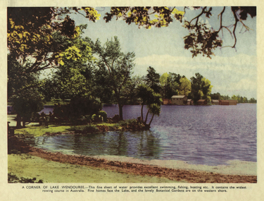
A coloured image of Lake Wendouree with boat sheds in the distance.ballarat botanical gardens, lake wendouree, boats, boatshed, landscape, parks and gardens -
 Sunbury Family History and Heritage Society Inc.
Photograph, 25th August 1995
This view of Sunbury Railway Station was taken from the corner of Brook and Evans Streets two years after the station underwent refurbishment and extensions and a carpark was constructed adjacent to the station. The Sunbury & District Heritage Association Inc. has a photograph P0663 of the station taken a century ago from the same place, when Sunbury was a small country town. The contrast between the two images is interesting. A coloured photograph of a streetscape with a weatherboard building in the middle distance,sunbury railway station, brook street -
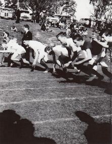 St Patrick's Old Collegians Association (SPOCA)
Photograph - Sports, Athletics
-
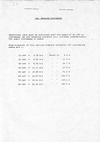 Melbourne Tram Museum
Document, "LRV Braking distances", c1990
Sheet produced to show drivers the length that a LRV (B class) takes to stop at speeds at full service braking from 10kmph to 80kmph - varies from 2.9m to 189.9mYields information about tram braking distances for LRVsPhotocopied sheet A4 titled "LRV Braking distances"tramways, trams, brakes, tram brakes, lrv, b class -
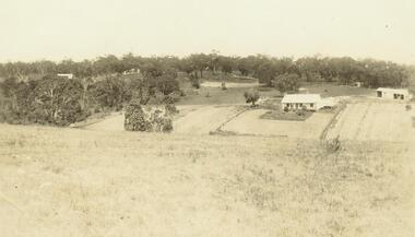
 Ringwood and District Historical Society
Photograph, Quambee, North Ringwood, from Coombes' property - 1912
Sepia photograph showing house and other buildings in the distance.Written on back of photograph, "Quambee - from Coombes, 1912." -
 Ringwood and District Historical Society
Photograph, Quambee, North Ringwood - 1912
Sepia photograph showing the house and other buildings in the distance.Written on rear of photograph: "Quambee 1912." -
 Hume City Civic Collection
Photograph, Early 1980's
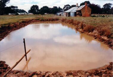
The mud brick cottage and outbuilding was possibly built by James Waylett in the 1850's and it is only one of three remaining mud brick buildings in the Oaklands-Greenvale which were constructed in the late 19th Century.A coloured photograph of farm scene. A dam is in the foreground and the remains of a mud brick cottage and timber and corrugated building in the middle distance. Further farm buildings can be seen in the distance.mud brick buildings, waylett, james, farm buildings, sherwood, somerton road, oaklands hunt club, george evans collection -
 Bendigo Historical Society Inc.
Photograph - HARRY BIGGS COLLECTION: NEW MOON TRAMWAY, Circa 1900
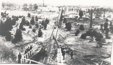
Photograph of the New Moon battery Tramway, Eaglehawk. The tramway extends from the foreground into the far distance, the tramway is in a cutting in the foreground and on a trestle way in the distance. There is a group of men standing around a railing fence looking at the tramway. There is a large round brick chimney in the middle distance and another visible in the background.Robinsonplace, mining site, new moon, new moon, tramway, battery -
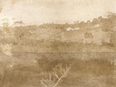
 Mt Dandenong & District Historical Society Inc.
Photograph
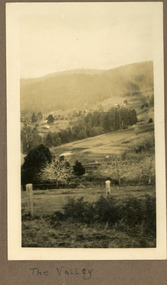
The photograph is from the album of Ivy Child and shows a view across the Kalorama Valley sometime between 1927 and 1932. Ivy May Child (1910 – 1989) was the daughter of Arthur Edward (Ted) Child (1878 – 1964) and Ethel May Madden (1888 – 1970). Ted Child was the son of Matthew Francis Child (1839 – 1933) and Martha Jeeves (1857 – 1926). He was the grandson of one of the early pioneers Francis Child. Ivy grew up on the family property on Childs Road and took many photographs. Most of these are glued into her photo album. The album covered the years from c1927 – 1932. Ivy married Henry William Burgess (1906 – 1968) in 1944. The photographs remain in their original state in the album with individual copies made. Sepia coloured photograph with a wire and pole fence in the foreground of a sweeping view across a valley. Numerous roof tops are visible in the distance. The land has been cleared. Hills are in the distance.Written below the photograph in the album: The Valleykalorama valley, kalorama, ivy child -
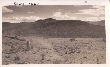 Kiewa Valley Historical Society
Photograph Farm Land, Kiewa, 25/8/38, circa 1938
This photograph was taken in august, 1938 some eight years prior to the establishment of Mt. Beauty as a township. The area was still being used for grazing cattle and the land was eventually acquired from the local land owners by the State Electricity Commission. The construction of the road, from Tawonga to the High Plains, was commenced in April of 1938. This allowed men and heavy equipment to be transported to the work sites for the construction of the Kiewa Hydro Electric Scheme. Prior to this access was by bridle trail, either on horse back or by foot. By 1946 housing construction had commenced for the new town of Mt. Beauty and by 1948 street construction in the southern part of the town was completed as far as Hill Street.This is an important photograph as it shows the upper Kiewa Valley and the site for Mt. Beauty as it was before the establishment of the town. The land has been cleared of natural vegetation and used for grazing cattle.Black and white photograph of farmland, cattle in the distance, hills in the backgroundHandwritten in the upper left hand corner, in black ink, 'Kiewa 25/8/38'. The number 8 has been stamped in the upper right hand side of the photograph. On the back have been stamped the words Velox, indicating the type of photographic paper.kiewa, mt. beauty, construction, grazing, secv