Showing 2941 items
matching early victorians
-
 Orbost & District Historical Society
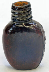
bottle, first half 20th century
... . the eucalyptus oil industry was a significant early Victorian industry ...In 1852 Bosisto opened Australia’s first commercial eucalyptus oil distillery, at Dandenong Creek in Victoria, followed by others at Emerald, Menzies Creek and Macclesfield. and began selling the oil locally. Eucalyptus oil was used as a liniment. Bosisto's bottles were generally used for eucalyptus oil. the eucalyptus oil industry was a significant early Victorian industry. Bosisto's products were commoly used in households of the first half of the 20th century. A flat-sided, brown, glass bottle with a threaded top. It has rounded shoulders.in rectangle on back - THIS BOTTLE IS AND ALWAYS REMAINS THE PROPERTY OF J. BOSISTO & COMPANTY LTD on base - F1196 M and 239 vertically -
 Orbost & District Historical Society
memorial document, 18th July, 1922
This is an extract from the Victorian Parliamentary Debates on Tuesday 18th July, 1922. It is titled "Death of the Honorable James Cameron" and is a tribute from Mr Lawson, the Victorian premier. In 1882 James Cameron was the first Orbost councillor of the newly constituted Tambo Shire. In the next twenty years he served as justice of the peace, shire councillor, guardian of St James's Anglican Church, Sunday school superintendent and president of the local agricultural society. In 1902 he won a by-election for Gippsland East and took his seat in the Legislative assembly. He serve for eighteen years and his main achievements were securing one million pounds for East Gippsland development bringing the railway to Orbost and establishing the Country Roads Board.James Cameron was an early Orbost pioneer, a respected community member and a prominent politician.A memorial extract from the Victorian Parliamentary Debates. It is on white paper with black print, a black border and is tied with black ribbon.cameron-james-orbost -
 Orbost & District Historical Society
certificate, 29th February 1868
This Elector's Right Certificate, No. 206179, is for Samuel Richardson, a sawyer, who lived at Bullarook in the Ballarat East Division. It has been signed by W. Cantwell, the registrar and by Samuel Richardson. As a resident and a male he was entitled to vote in the Ballarat East Division at Victorian State elections. Samuel Richardson was a sawmiller and farmer in Orbost. He built The Curlip, a wooden paddle-steamer of 9 tons gross and dimensions of 43 feet long, 10 feet wide and a depth of 3 feet, on the slipway at their Tabarra sawmill in 1890. This item is associated with the Richardson family, early Orbost pioneers,A white paper certificate with black print and hand-written details. at the top is the British coat-of-arms. It is an elector's right certificate made out to Samuel richardson.suffrage richardson-samuel elector's-right-certificate -
 Orbost & District Historical Society
documents, 1977-1978
The Orbost Rifle Club existed in the early 20th century. (There are records from 1900). It folded in the late 1970's.Target shooting is one of the oldest organised sports in Australia. Records date back to the British Marines at Sydney Cove in 1788. The Victorian Rifle Association (VRA) was formed in 1860. One of the most important adjuncts to the militia system from 1903 to the re-organisation of 1912 was the role played by the Rifle Club movement in Australia. At the time, these clubs were seen as the reservoir of manpower for a potential guerrilla force should any invasion occur. For Australia, the invasion fear was uppermost in the minds of the population. So important were the rifle clubs for the defence of Australia that the Commonwealth provided the training staff, rifles and ammunition so the clubs could function. Members were drilled, wore uniforms and practised all the basic skills of soldiering as well as target shooting. The Orbost Rifle Club was active during this period.Nine envelopes containing correspondence sent to Mr D. Thexton, Secretary of Orbost Rifle Club in 1977-1978. Some are from the Victorian Rifle Association.orbost-rifle-club shooting -
 Orbost & District Historical Society
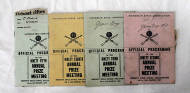
programs, 1967-1970
The Victorian Rifle Association governs the operation of rifle ranges and target shooting clubs throughout Victoria. The Association was formed in 1860 and held its first individual competition at the end of that year. These programs were used by C. Curtis of the Orbost Rifle Club.The Orbost Rifle Club existed in the early 20th century. (There are records from 1900). It folded in the late 1970's. It had a substantial membership.Four programs for the Victorian Rifle association Annual Prize Meeting. 2090.1 has a pink cover -1967. 2090.2 has a pale green cover -1968. 2090.3 has a yellow cover -1969. 2090.4 has a pale green cover-1970. Inside 2090.4 is a newspaper cutting.orbost-rifle-club shooting victorian-rifle-association -
 Orbost & District Historical Society
book, Orbost Rifle Club, Match Record Book, 5th January, 1974 ; 13th May, 1978
Cec, Curtis was a member of the Orbost Rifle Club. He was a cycle trader with a business in Lind Lane, Orbost. The Orbost Rifle Club existed in the early 20th century. (There are records from 1900). It folded in the late 1970's.Target shooting is one of the oldest organised sports in Australia. Records date back to the British Marines at Sydney Cove in 1788. The Victorian Rifle Association (VRA) was formed in 1860. One of the most important adjuncts to the militia system from 1903 to the re-organisation of 1912 was the role played by the Rifle Club movement in Australia. At the time, these clubs were seen as the reservoir of manpower for a potential guerrilla force should any invasion occur. For Australia, the invasion fear was uppermost in the minds of the population. So important were the rifle clubs for the defence of Australia that the Commonwealth provided the training staff, rifles and ammunition so the clubs could function. Members were drilled, wore uniforms and practised all the basic skills of soldiering as well as target shooting. The Orbost Rifle Club was active during this period A light blue covered book with a bright red spine. It contains hand-written records of the shooters who were members of the Orbost Rifle Club. Inside are seven letter heads of CED. CURTIS - 9 LIND ST ORBOST and a newspaper cutting ( date unknown). orbost-rifle-club shooting -
 Orbost & District Historical Society
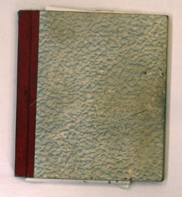
book, Match Record Book, 13.1.1965 - 12.5. 1973
The Orbost Rifle Club existed in the early 20th century. (There are records from 1900). It folded in the late 1970's.Target shooting is one of the oldest organised sports in Australia. Records date back to the British Marines at Sydney Cove in 1788. The Victorian Rifle Association (VRA) was formed in 1860. One of the most important adjuncts to the militia system from 1903 to the re-organisation of 1912 was the role played by the Rifle Club movement in Australia. At the time, these clubs were seen as the reservoir of manpower for a potential guerrilla force should any invasion occur. For Australia, the invasion fear was uppermost in the minds of the population. So important were the rifle clubs for the defence of Australia that the Commonwealth provided the training staff, rifles and ammunition so the clubs could function. Members were drilled, wore uniforms and practised all the basic skills of soldiering as well as target shooting. The Orbost Rifle Club was active during this period A grey cardboard covered book with a red spine. It contains hand-written match records of the members of the Orbost Rifle Club.records orbost-rifle-club shooting -
 Orbost & District Historical Society
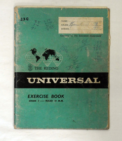
book, Handicaps, 1968
The Orbost Rifle Club existed in the early 20th century. (There are records from 1900). It folded in the late 1970's.Target shooting is one of the oldest organised sports in Australia. Records date back to the British Marines at Sydney Cove in 1788. The Victorian Rifle Association (VRA) was formed in 1860. One of the most important adjuncts to the militia system from 1903 to the re-organisation of 1912 was the role played by the Rifle Club movement in Australia. At the time, these clubs were seen as the reservoir of manpower for a potential guerrilla force should any invasion occur. For Australia, the invasion fear was uppermost in the minds of the population. So important were the rifle clubs for the defence of Australia that the Commonwealth provided the training staff, rifles and ammunition so the clubs could function. Members were drilled, wore uniforms and practised all the basic skills of soldiering as well as target shooting. The Orbost Rifle Club was active during this period. A green Universal exercise book which contains hand-written handicap record of the Orbost Rifle Club. On front cover - handwritten - Handicap Recordsorbost-rifle-club shooting records -
 Orbost & District Historical Society
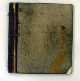
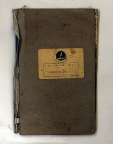
inventory book, 1950-1970
The Orbost Rifle Club existed in the early 20th century. (There are records from 1900). It folded in the late 1970's.Target shooting is one of the oldest organised sports in Australia. Records date back to the British Marines at Sydney Cove in 1788. The Victorian Rifle Association (VRA) was formed in 1860. One of the most important adjuncts to the militia system from 1903 to the re-organisation of 1912 was the role played by the Rifle Club movement in Australia. At the time, these clubs were seen as the reservoir of manpower for a potential guerrilla force should any invasion occur. For Australia, the invasion fear was uppermost in the minds of the population. So important were the rifle clubs for the defence of Australia that the Commonwealth provided the training staff, rifles and ammunition so the clubs could function. Members were drilled, wore uniforms and practised all the basic skills of soldiering as well as target shooting. The Orbost Rifle Club was active during this period. A plain grey covered indexed book with a light blue cloth spine. It has a yellow label on the front cover. It appears to be a record of individual results for the Orbost Rifle Club.On label - printed - ORBOST RIFLE CLUB 211orbost-rifle-club shooting records -
 Orbost & District Historical Society
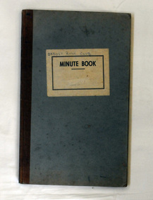
minute book, 8.6.1961 - 15.2.1978
The Orbost Rifle Club existed in the early 20th century. (There are records from 1900). It folded in the late 1970's.Target shooting is one of the oldest organised sports in Australia. Records date back to the British Marines at Sydney Cove in 1788. The Victorian Rifle Association (VRA) was formed in 1860. One of the most important adjuncts to the militia system from 1903 to the re-organisation of 1912 was the role played by the Rifle Club movement in Australia. At the time, these clubs were seen as the reservoir of manpower for a potential guerrilla force should any invasion occur. For Australia, the invasion fear was uppermost in the minds of the population. So important were the rifle clubs for the defence of Australia that the Commonwealth provided the training staff, rifles and ammunition so the clubs could function. Members were drilled, wore uniforms and practised all the basic skills of soldiering as well as target shooting. The Orbost Rifle Club was active during this period. A plain light blue minute book with a cloth brown spine. It has a white label on the front cover.On label- Orbost Rifle Clubminutes orbost-rifle-club shooting -
 Orbost & District Historical Society
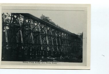
postcard, C1920-1940
This photograph shows the second major bridge across the Snowy River at Orbost. The current Snowy River bridge is the fourth to provide a crossing to the township of Orbost. The first, in 1891, lasted just two years before it succumbed to flood waters. The bridge in this photograph was built in the 1920s as a road and rail bridge, and was again partly washed away by flood waters in 1934. After the end of the first World War the Victorian Railways considered an extension of the railhead across the river at Orbost, and in 1922 a new timber and steel girder structure, a joint Country Roads Board — Victorian Railways venture, was built and completed at a cost of £41,000 (the steel girders came from the Flinders Street viaduct reconstruction). Subsequently it was decided not to take the railway across the river, and the bridge was only used by road traffic. It was severely battered by floods during its life. and after the 1971 floods was eventually replaced by the current bridge in 1975. (info from Newletter 54N by John Phillips) This item is an early pictorial record of the previous Snowy River bridge at Orbost.A postcard with a black / white photograph of a bridge - timber and steel girder structure - across the Snowy River at Orbost, Reflections of the bridge are seen in the water.snowy-river-bridge-orbost -
 Orbost & District Historical Society
black and white photograph, first half 20th century
The Stony Creek Trestle Bridge was built in 1916 when the existing rail line from Melbourne to Bairnsdale was extended to Orbost. This 97km Bairnsdale to Orbost extension through rugged terrain was reputed to have been the most difficult rail project undertaken in Victoria. In service for over 60 years the bridge was damaged by bushfire in 1980, with the last train crossing in 1987. At 247m long and 20m high, it is the largest standing bridge of its kind in the State, and is listed on the Register of Historic Sites. Built of red ironbark and grey box timber, it is a fine example of the early engineering skills that utilised the resources and materials found on site.The Bairnsdale to Orbost rail line contains the most varied range of timber & timber composite bridges on any Victorian line. The Stoney Creek bridge is listed on the Victorian Heritage Register for its architectural and historical significance. A black / white photograph of a very tall wooden railway bridge with a train along the top.railway-bridge stoney-creek-bridge east-gippsland-railway -
 Orbost & District Historical Society
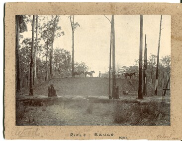
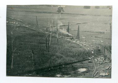
black and white photograph, Wood, 1901
This photograph appears to have been taken during the construction of the rifle range just north of the Orbost township. "The photo shows the range stop butt being formed by the scoops being pulled by the horses. It appears that the rear of the mound there is a wall of logs lining it, most likely to help with being eroded or washed away. They haven’t yet formed the mantlet and target machines." ( Info, from Victorian Rifle Association) The Orbost Rifle Club existed in the early 20th century. (There are records from 1900). It folded in the late 1970's.Target shooting is one of the oldest organised sports in Australia. Records date back to the British Marines at Sydney Cove in 1788. The Victorian Rifle Association (VRA) was formed in 1860. After Federation in 1901, rifle clubs came under army control, but in 1921 they were reconstituted as a civilian organisation, which they have remained ever since. After World War I a system of national training was embodied in the Defence Act and the rifle clubs reverted to their purely sporting role. A black / white photograph of four men and four horses standing an a soil bank with another man, a lady and a small girl at the base of the hill. It is in a clearing in forest. It appears to have a row of targets set at the edge of the bank. The photograph is mounted on a very mouldy cream coloured buff card.on front - "Wood" ; "Rifle Range - 1901" ; "Orbost 1901"sport-shooting orbost-rifle-range -
 Orbost & District Historical Society
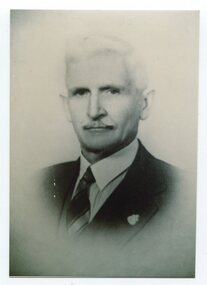
black and white photograph, C1944
This is a photograph of Councillor Jacob Perry who represented Central Riding in the Orboast Shire Council from 1928 - 1931. and from 1934 - 1944. He was president twice in 1934-1935 and 1943-1944 Jacob Perry was an Orbost farmer. Born 1874. Died 1950. He was a Boer War veteran , 4th Victorian Imperial Bushmen. He was a shire councillor and worker for school affairs.This item is associated with the Orbost Shire Council. The shire covered an area of 9,347 square kilometres and existed from 1892 until 1994 when it became part of the East Gippsland Shire Council. It is also associated with the Perry family early Orbost settlers.A black / white head and shoulders portrait photograph of a moustached man in a suit.on back - "Cr Jacob Perry J.P."perry-jacob orbost-shire-council -
 Orbost & District Historical Society
black and white photographs, Howard D. Bulmer, first half 20th century
This bridge was built in the 1920s as a road and rail bridge, and was partly washed away by flood waters in 1934. After the end of the first World War the Victorian Railways considered an extension of the railhead across the river at Orbost, and in 1922 a new timber and steel girder structure, a joint Country Roads Board — Victorian Railways venture, was built and completed at a cost of £41,000 (the steel girders came from the Flinders Street viaduct reconstruction). Subsequently it was decided not to take the railway across the river, and the bridge has only been used by road traffic. This is a pictorial record of an early bridge across the Snowy River at Orbost.A large black / white photograph of the Orbost Snowy River bridge. There is a large copy as well as a postcard copy in sepia.on front - Snowy River Bridge Orbost H.D. Bulmer - photo - Lake Tyers.snowy-river-bridge-orbost -
 Orbost & District Historical Society
black and white photograph, 1916
This photograph shows the pile drivers at work in the construction of the viaduct across the Snowy River flats. The Snowy River Floodplain Railway Bridges, two sequential and exceptionally long and low timber railway bridges on the Snowy River floodplain just west of Orbost, were built in 1916, and provided the original terminus point for the Bairnsdale-Orbost railway. The bridges are 770 metres and 183 metres long respectively. The shorter bridge is of uniformly 4.57 metre timber-beam construction, and has a sweeping curve in its deck. The longer bridge has a combination of 4.57 metre and 6.1 metrespans, and two 3.66 metre spans. The bridges are constructed from 'Southern Mahogany', Eucalyptus Botryoides, which grew along the coast east of Bairnsdale. The Snowy floodplain bridges were initially built in the context of an early twentieth-century interest in American-style 'Developmental Railways', designed to open remote areas to closer settlement, even if that meant running at a loss. The line was closed in August 1987. (information from Victorian Heritage Database)This item is associated with the history of the Orbost-Bairnsdale railway line and therefore reflects the role that the rail line played in the social and economic history of Orbost.A black / white photograph of the farming flats at Orbost during the construction of the East Gippsland railway.orbost-railway east-gippsland-railway viaduct-orbost transport railway -
 Orbost & District Historical Society
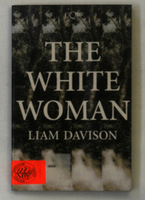
book, The White Woman, 1994
The white woman of Gippsland, or the captive woman of Gippsland, was supposedly a European woman rumoured to have been held against her will by Aboriginal people in the Gippsland region of Australia in the 1840s. Liam Patrick Davison (29 July 1957 – 17 July 2014) was an Australian novelist and reviewer. He was born in Melbourne, where, until 2007, he taught creative writing at the Chisholm Institute in Frankston. Davison and his wife Frankie, a teacher at Toorak College, were both killed on 17 July 2014 aboard Malaysia Airlines Flight 17 This, his third novel, was shortlisted for both The Age Book of the Year and the Victorian Premier’s Awards.This is a useful research tool on the history of indigenous and settler relationships in early Gippsland.A book titled "The White Woman" by Liam Davison. It is the story of the search for the lost white woman in Gippsland, Victoria, 1846. The cover has a black and white picture of forest with the title in white print.Bottom left corner - orange sticker Orbost Secondary Collegedavison-liam aboriginal-history -
 Orbost & District Historical Society
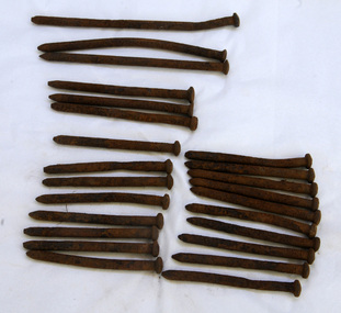
bridge spikes, 1922
These spikes are from the old Snowy River bridge (the second) constructed in 1922 alongside the previous suspension bridge. Its building was a combined effort of the Victorian Railways and the Country Roads Board at a cost of 35,000 pounds. It was replaced in 1976 by the present bridge after several major floods.These items are from a significant piece of infrastructure built in Orbost in the early 20th century. This bridge no longer exists.Twenty-four iron spikes of four different lengths. They are probably hand-made and have round shafts and heads. They are very rusty.snowy-river-bridge bridge-spikes bridge orbost -
 Orbost & District Historical Society
bottle, Early 1900's
This item reflects the changes in Victorian medical practice and public health over the century. The container is of a type common in the early 20th century. Very small brown pill bottle with spiral neck. There is no lid.Underneath "RI" Sides Tabloid 542595 Sw & Cobottle tabloid glass medicine pharmacy -
 The Beechworth Burke Museum
Photograph - Photograph - Reproduction, ca. 1900
This image shows the approach to Beechworth from the south-west via the Newtown Bridge. Numerous early buildings line the road as it bifurcates to become Ford and High Streets on the ridge above Spring Creek and Newtown Falls. The sloping, rocky terrain and water course along the gorge show evidence of the intense mining activity that occurred at the site. The Ovens Gold Rush at Beechworth started when gold was found at Spring Creek in February 1852, prompting an influx of miners from around the world. The population grew over 20,000 by 1857. While the earliest mining at Beechworth was similar to that in other Victorian goldfields like Ballarat and Bendigo, Beechworth is notable for its use of hydraulic sluicing as a major method of removing wash-dirt. Hydraulic sluicing employs high pressure jets of water to blast away large areas of earth and wash it down to be run through a sluice box. Gold gets caught in the sluice and the remaining slurry is washed away. This method of mining is extremely effective but causes significant environmental impacts and damage to waterways. Large water quantities were required for large-scale sluicing, and the long water races and deep tailraces that were constructed in the Beechworth area in the nineteenth century are nonetheless considered feats of engineering. The site in the photograph is associated with the Rocky Mountain Mining Company who constructed an eight hundred meter tunnel under the township between 1876-1880 to reduce water levels at Spring Creek, which had been subject to diversions since the earliest days of alluvial mining. Over four million ounces of gold (115 tones) were found at Beechworth between 1852 and 1868, and the wealth from the gold rushes built Beechworth and the nationally significant buildings that remain standing today.This image shows the early development of the Beechworth township above Spring Creek, where gold was discovered in 1852. Evidence of hydraulic sluicing, a uniquely predominant method at Beechworth, and water-works engineering are present in the landscape. By the 1870s, alluvial gold deposits were depleted and increasingly complex engineering was required so deeper shafts could reach bedrock. This image is significant for understanding changes to the landscape and the evolution of mining methods and engineering practices related to the extensive construction, manipulation and management of water networks. The shift from smaller scale alluvial mining to larger company dominance in the mining industry has implications for understanding wider social, economic, political and industrial changes in the region of Beechworth and within the context of the Victorian Gold Rush more broadly. A black and white rectangular reproduction photograph printed on photographic paper. burke museum, beechworth museum, beechworth, gold fields, gold rush, victorian gold rush, hydraulic sluicing, rocky mountain mining company, spring creek, netwown falls, mining tunnels, water races, tailraces, colonial australia, australian gold rushes, mining technology, beechworth historic district, indigo gold trail, migration, indigo shire, gold mining, gold mining history -
 The Beechworth Burke Museum
Photograph - Photograph - Reproduction, Unknown
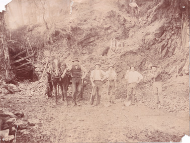
This image is a reproduction of an 1899 original depicting the 'Williams Good Luck Mine' on the Mopoke Reef (also called 'Morepork Gully') in the Dingle Ranges, approximately three miles from Beechworth. The foreground of the image is littered with piles of smashed rock and detritus, known as ‘mullock’, beside a reinforced mine shaft, a vertical access passageway allowing miners to enter the mine and haul ore out using lifting technology such as a poppet heads, whims or windlasses. A group of miners and a dog appear close to an open-sided miner’s hut. Following the discovery of gold at Beechworth in 1852, rushes quickly followed at surrounding creeks and gullies in the district. In the late nineteenth and early twentieth centuries, small syndicates of miners continued to work old or abandoned quartz reefs, often persisting without the assistance of heavy machinery to remove the large amounts of rock, in order to obtain yields at ever greater depths. The group of miners in this photograph are Mr. Roger Williams and Sons, who revived operations at the ‘Old Good Luck’ mine on the Mopoke Reef in the Dingle Range near Beechworth around 1892, working the site for more than two decades. An emigrant from Cornwall with experience in the tin mining industry, 19 year old Roger Williams senior sailed to New Zealand in 1840, then to Australia where he spent time in the Bendigo Gold Fields before settling in Beechworth in the early 1860s. Mr Williams senior worked on various mining activities in the district, including the Rocky Mountain Tunnel project. Conversant with the character of gold-bearing reefs in the area, the syndicate dug an eight hundred foot tunnel, digging down as far down as two hundred feet with little capital save their labour, to connect and provide better working access to the mass of reefs and veins in the vicinity. Progress was hampered by poor air quality charged with fumes from dynamite and large quantities of rock had to be crushed to obtain payable yields. The Victorian Goldfields are filled with ruins and remnants of the area's rich mining history, ranging from small alluvial diggings to the remains of huge mining companies. Site names often changed several times throughout the nineteenth and twentieth centuries. Some sites were abandoned and forgotten, others were worked continuously over many decades. The names of mines were often repeated at different locations throughout the Victorian Goldfields. For example, there is a Mopoke Gully heritage mine near Fryers Creek, Victoria. 'Mopoke' is a common onomatopoeic name for Morepork and Australian Boobook owls. This image has historical, social and research significance for patterns of emigration during of the Victorian Gold Rush, and the historical, social and environmental impacts of mining at Beechworth at the turn of the nineteenth and twentieth centuries. As gold became scarce and government support and large company investment waned, poor hard-working miners laboured intensively to make a living through periods of high unemployment. This image can be compared and studied alongside other historical mining photographs and objects in the Burke Museum Collection. It has potential to improve our understanding of miners working conditions and the shifting character of mining in the Beechworth district. Black and white rectangular reproduction photograph printed on matte photographic paper.Obverse: Williams Good Luck Mine Beechworth / Roger! / Reverse: 6858 / burke museum, beechworth museum, beechworth, gold fields, gold rush, victorian gold rush, gold ming history, colonial australia, australian gold rushes, mining technology, beechworth historic district, indigo gold trail, migration, indigo shire, good luck gold mine, victorian goldfields, mining syndicates, gold fever, quartz-mining, small-scale mining, old good luck mine, mopoke gully, quartz reefs beechworth -
 The Beechworth Burke Museum
Photograph
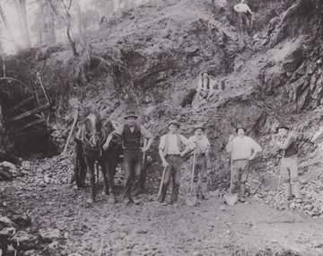
This photograph depicts a reef mine in Beechworth. Reef mining, or quartz reef mining, was common in 19th Century Victoria. This gold mining technique requires mine shafts to be sunk into underground quartz reefs, with horizontal tunnels dug from the original shaft at differing levels to find the gold-bearing rock. The quartz would then be hoisted to the surface, which would then be pounded to access the gold in its metallic state. Gold was discovered in Beechworth in February 1852, at Spring Creek. Within 11 months of that discovery, over 8000 hopeful prospectors quickly descended on this region, transforming it into a thriving, wealthy township. Reef mining and hydraulic sluicing were gold mining techniques used in this region in the 19th and early 20th centuries. This photograph interestingly contains dogs alongside the miners. While dogs have been recorded as deterrents to thieves in the Victorian goldfields, these dogs appear as companions to these men.The search for gold is ingrained into the history of Victoria and therefore, images like this one can reveal important information for society and technology for the date when the photograph was taken. It also shows a location where reef mining was undertaken which provides insight into the impact on the environment at a time when it was done. Although quartz is one of the most common minerals found in the earth's crust, it does not always contain gold. Those reefs that do are rare and highly sought after by prospectors. The Beechworth Burke Museum has additional images relating to gold mining which can be analysed and studied alongside images like this one.Sepia coloured rectangular photograph printed on gloss photographic paper. Obverse: Reverse: United Shire of Beechworth/ Shire Secretary/ Reef Mining, Beechworth./ 6167.abeechworth, burke museum, gold, gold mining, gold rush, victorian gold rush, reef mining, quartz, companion dog, horse and cart -
 The Beechworth Burke Museum
Photograph - Photograph - Reproduction
This reproduced photograph depicts a reef mine in Beechworth. Reef mining, or quartz reef mining, was common in 19th Century Victoria. This gold mining technique requires mine shafts to be sunk into underground quartz reefs, with horizontal tunnels dug from the original shaft at differing levels to find the gold-bearing rock. The quartz would then be hoisted to the surface, which would then be pounded to access the gold in its metallic state. Gold was discovered in Beechworth in February 1852, at Spring Creek. 8000 hopeful prospectors quickly descended on this region within the year, transforming it into a thriving, wealthy township. Reef mining and hydraulic sluicing were gold mining techniques used in this region in the 19th and early 20th centuries. This reproduction photograph interestingly contains dogs alongside the miners. While dogs have been recorded as deterrents to thieves in the Victorian goldfields, these dogs appear as companions to these men.The search for gold is ingrained into the history of Victoria and therefore, images like this one can reveal important information for society and technology for the date when the photograph was taken. It also shows a location where reef mining was undertaken which provides insight into the impact on the environment at a time when it was done. The Beechworth Burke Museum has additional images relating to gold mining which can be analysed and studied alongside images like this one.Black and white rectangular reproduction photograph on gloss photographic paper. Obverse: Reverse: L is miners 26%/ 10 x 8/ 6167.bbeechworth, burke museum, gold, gold mining, gold rush, victorian gold rush, reef mining, quartz, companion dog, horse and cart -
 The Beechworth Burke Museum
Photograph, 1920-1950
This image taken between 1920-1930 depicts open-cut hydraulic sluicing at the Three Mile Mine, located about five kilometres south of Beechworth. Alluvial, or surface, mining began on this site in the 1850s, but was soon replaced by hydraulic sluicing methods. By the start of 1880 it is estimated that nine hundred miles of water races had been cut though soil and rock in the Beechworth district. Hydraulic sluicing employs high pressure jets of water to blast away large areas of earth and wash it down to be run through a sluice box. Gold gets caught in the sluice and the remaining slurry is washed away. Large water quantities were required for hydraulic sluicing, and the long water races and deep tailraces that were constructed were considered great engineering feats. This method of mining is extremely effective, but causes significant environmental damage and impacts to waterways and agricultural operations. Miners at Beechworth built extensive networks of races and dams to secure reliable supplies of water on a scale far greater than elsewhere in Victoria. By the 1880s Beechworth's water barons continued to hold more than half of all the water right licences on issue and undertook sluicing operations on a massive scale. The manipulation of surface and ground water via race networks was well planned and recorded in detail by local mining surveyors. The maps that were created, combined with modern geo-spatial technologies, provide a vital key in understanding the great lengths to which miners went to capture and control critical water resources. Today, Three Mile mine is called Baarmutha. The Three Mile Mine was unproductive until 1865 when John Pund and three other miners secured a fifteen year license and constructed a water race from Upper Nine Mile Creek to Three Mile Creek. In the early twentieth century Pund & Co. averaged over one thousand ounces of gold per year from the mine. After Pund's death in 1915, GSG Amalgamated Co operated the site, continuing sluicing until 1950. This image of hydraulic sluicing methods shows the extent of water-works engineering in the landscape. This photograph has historic and research potential for understanding changes to the landscape, the evolution of mining methods, and the extensive construction, manipulation and management of water networks in the Beechworth district. Black and white rectangular photograph on matte paperReverse: 7597-1 / Sluice Mining / Copied from original on loan from Webb (Qld) / Donated Nov 2009 / Baarmutha Three Mile Mine c1920-1950 / Managed by the Plain Bros then Parkinsons / Current Location is: Beechworth Animal Shelter / used for Baarmuthaburke museum, beechworth museum, beechworth, gold fields, gold rush, victorian gold rush, hydraulic sluicing, spring creek, netwown falls, mining tunnels, water races, tailraces, gold ming history, colonial australia, australian gold rushes, mining technology, beechworth historic district, indigo gold trail, indigo shire, john pund, water manipulation, water engineering, three mile creek, three mile mine, water race, large-scale mining methods, historical mining construction, alluvial mining, mining environmental impacts, baarmutha, water barons -
 The Beechworth Burke Museum
Photograph
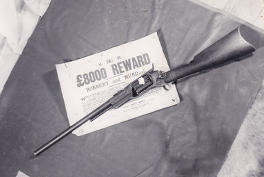
In this image a Colt 1855 Revolving Rifle is placed upon a sign detailing an £8,000 reward for robbery and murder. Writing on the rear of the photograph identifies the rifle as having belonged to Joe Byrne. In colonial Victoria, the Colt brand firearm was highly popular. They began their popularity in the goldfields of the early 1850s. Individuals, particularly those coming to Victoria with prior experience in the goldfield, brought with them a means of self-defence because of the prevalence of assault and robbery on the goldfields. In the 1860s, the Colt firearm became popular among the Victorian Police force. It was decided in June 1864 by Chief Commissioner of Police, Frederick Standish that the Colt revolvers were far more practical, being of simpler construction and therefore, more easily cleaned and less dangerous than the revolvers used prior to this: the Adams and Kerr firearms. The Colt revolver remained in use in regional districts of Victoria as late as the early 1880 when they were used at the Kelly siege at Glenrowan. The £8,000 reward was issued in 1879 after the Kelly Gang committed numerous bank robberies at Euroa and Jerilderie. In the year prior, the Kelly Gang murdered three policemen at Stringybark Creek. This resulted in the creation of the “Felon’s Apprehension Act 1878” which enabled an individual, whether a part of the Police force or civilian, to shoot a declared outlaw on sight. After the bank robberies, the Police force of NSW and Victoria increased the existing reward to this £8,000 amount.This photograph is significant for what it can potentially reveal about the Kelly Gang and firearms made in this period. The rifle in the image is a Colt Revolving Rifle which was known to have been used by the Victorian Police force from the early 1850s to the late 1880s. It is also known that the Kelly Gang stole police rifles which they used to practise with and so the identification of the rifle as having belonged to Joe Byrne is of significant importance to researchers studying the firearms of the Kelly Gang. More research is needed to solidify the connection of this particular weapon to Byrne other than the handwritten note on the back of the photograph. The Burke Museum Beechworth is home to a significant collection of photographs connected to Ned Kelly and the Kelly Gang. Photographs like this one are valuable for what they can potentially reveal about the Kelly Gang and the Police force during this period. Alongside the study of the other images, photographs from this collection have the ability to further expand current knowledge on this period of Australian history. There is also the capability to provide an analysis of how these firearms and Kelly memorabilia have been received in the past. It could be beneficial to undertake a close study of the use history and reception of these artefacts within the museum context.Black and white rectangular reproduced photograph printed on matte photographic paperReverse: 10268 / Joe Byrne's / Riflekelly album, ned kelly, kelly gang, joe byrne, rewards, outlaw, criminals, bushrangers, colt, police, firearm, beechworth, reward, felon's apprehension act 1878, 1880, glenrowan, colt revolver, revolving rifle, 8000 pound reward, jerilderie, euroa, beechworth goldfield -
 The Beechworth Burke Museum
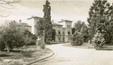
Postcard, George Rose, c.1945
The Rose Stereograph Company first began producing postcards, identified as the 'P' series (like this particular example) in 1913 and continued in this business until 1967 after which they switched to machine manufactured colour postcards printed by an external company. These were produced by Victorian-era photographer George Rose (1861-1942) often reputed as one of the best photographers in Australia during the later 19th Century and early 20th Century. Rose was born in 1861 in Clunes and began his photography business in 1880 when he founded the Rose Stereograph Company. He later switched to producing postcards after stereographs lost popularity in the early 1920s. The Mayday Hills Hospital was one of these locations photographed by George Rose and published as a postcard. Beechworth's Mayday Hills was chosen as the site of Victoria's newest asylum, at the time, due to the landscape and altitude. The hilltop atmosphere and the native fauna, it was argued, would assist in the cure of the patients kept at the hospital (Wood 1985, 122). The positioning of the hospital had a beneficial effect on the rural town. A pamphlet published by James Ingram and Son (1849) reveal that famous landmarks in Beechworth which included the Post Office, Gaol, Courthouse and Asylum "demonstrate the appreciation of Beechworth by the Government not only as as important district center, but also as a site unrivaled as a sanitarium". There were other locations in contention at the time, but ultimately Beechworth was chosen (Craig 2000,33). Prior to the creation of the Asylum in Beechworth, those charged with having mental illnesses or, as it was termed, "insanity" were unable to be properly cared for in the Gaol (which is where they were often sent). John Buckley Castieau wrote, in 1861 for the Ovens and Murray Advertiser, that the Gaol was unable to properly care for those classified then as "insane" but that they would endeavor to treat them above the other inmates (which he notes is not always the case in other establishments). Castieau wrote this in favour of supporting the building of the Mayday Hills Hospital in Beechworth. It was stated that at the time the Mayday Hills Hospital was built, there were 83 prisoners kept in the Gaol who were to be rehoused to the Hospital on the grounds of "insanity". The classification as someone as "insane", in this period of time is a reflection on the inability to cure and understand illnesses of the mind during the mid to late 1800s. Opening on the 24th of October 1867, the Mayday Hills Hospital was originally named the "Ovens Lunatic Asylum", a title which is very much a product of its time. Whilst controversial, changes to the name is part of the history of the Hospital and can provide much insight into the understanding of mental illness throughout history and the use/disuse of this term provides information into the reception/changing opinions of mental illness in society. The Hospital would later become known as the "Mayday Hills Asylum" and/or "Mayday Hills Hospital" with the latter being the most commonly used title. An article in the Ovens and Murray Advertiser notes that on the 7th of March 1865, the foundation stone of the Hospital was laid (it would officially open in 1867) and that it was such a moment of accomplishment and joy for Beechworth that a letter to the editor even suggested that there should be a holiday dedicated to the day the foundation stone as laid. This reveals an extent to which the townspeople of early Beechworth valued the construction of the Hospital in their town. It provided the town with a sense of prestige and honour. At first glance, the remains of the Mayday Hills Hospital in Beechworth, Victoria, inspire tragedy, trauma and beauty. The buildings themselves, with their Italianate style Renaissance architecture designed by J.J. Clark (Craig 2000, 49 & Smith 2016, 203) reflect a bygone period of European and Australian history. The gardens provide a sense of tranquility and beauty. The experience of those within these walls remains a valuable area of study to provide a more complete understanding. This particular hospital is considered the fourth of its like and one of three identified as the largest of their kind. The Mayday Hills Hospital is a sister to the Kew and Ararat Asylums in Melbourne which are both located in relative proximity. Understanding the role of the Mayday Hills Hospital in Beechworth history is integral to understanding the development of the goldfields town, but also for providing important information as to the history of caring for, and the reception of, mental illnesses in Australian and wider European history. Mayday Hills provides a case study which can be researched through oral history, an analysis of the grounds/buildings and through images like this postcard which portray the structure in a highly deliberate manner. Images like this depict the strong façade of the Hospital and provide a glimpse into the tranquility of the gardens. This has been done deliberately to provide a sense of comfort and healing about the building to those looking from the outside. Further research into the importance of the Hospital in Beechworth and it's connection to the town will be supported through images like these kept in the Mayday Hills photo album in the collection of the Burke Museum.Pale sepia toned rectangular postcard printed on matte card.Obverse: THE ROSE SERIES P. 4689 / COPYRIGHT / ADMINISTRATIVE OFFICES, MENTAL HOSPITAL, BEECHWORTH, VIC / Reverse: Published by the Rose Stereograph Co. / Armadale, Victoria / POST CARD / THE "ROSE" SERIES / DE LUXE / A REAL PHOTOGRAPH / PRODUCED IN AUSTRALIA /mayday hills, asylum, mental hospital, hospital, beechworth -
 The Beechworth Burke Museum
Photograph, 1859
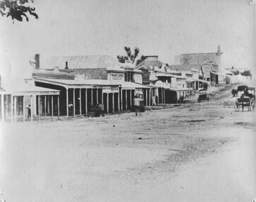
Taken in Beechworth 1859, this photograph depicts the south side of Ford street looking towards the Methodist Church. The Methodist Church was built in 1857, and was the first permanent church building on the Ovens goldfields. It was one of the first permanent churches built on the Victorian goldfields, and the first on the Ovens goldfield. It demonstrates the rapid development which occurred in the goldfield towns following the discovery of gold in the early 1850s. It reflects the importance of Methodism in Victoria at this time, and the early activities of the Wesleyan Methodist Church in taking their religious message to the gold miners. [https://vhd.heritagecouncil.vic.gov.au/places/104] The buildings ceased being used as a church in 1966 when the Methodist and Congregational churches in Beechworth amalgamated.Black and white rectangular photograph. Image is printed on matte photographic paper. Obverse: NO INSCRIPTION Reverse: 7775 Ford St Looking Southwest 1859 Burke Museum Beechworth beechworth, ford street, methodist church, 1859 -
 The Beechworth Burke Museum
Photograph
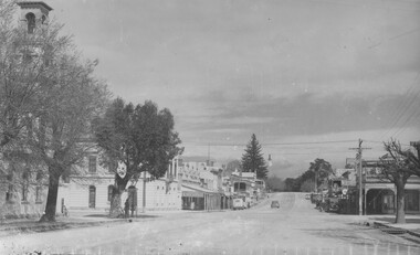
This photograph depicts Camp st in Beechworth looking east. This postcard is part of the Rose Series produced by Victorian photographer George Rose’s business, the Rose Stereograph Company. George Rose (1861-1942), is considered one of Australia's best photographers of the late 19th and early 20th centuries. The Rose Stereograph Company was founded in 1880 and became famous for producing stereographs, or stereoviews, which gave the illusion of being in 3D when seen through a hand-held viewer, a big craze of the era. As stereographs lost popularity in the 1920s, Rose switched to production of postcards and decorative cards, and he and the photographers who followed took thousands of scenes around Victoria as well as interstate that became iconic images of Australian life.Black and white rectangular photograph (copy) printed on gloss photographic paper. Obverse: The Rose Series P.3469 Copyright FORD STREET Reverse: BMM7744 PH150 1998.00059 beechworth, ford street, rose series, photograph, post card, black and white -
 The Beechworth Burke Museum
Photograph, c1940
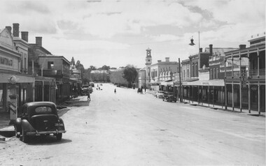
This copy of a postcard depicts Ford Street in Beechworth looking North. This postcard is part of the Rose Series produced by Victorian photographer George Rose’s business, the Rose Stereograph Company. George Rose (1861-1942), is considered one of Australia's best photographers of the late 19th and early 20th centuries. The Rose Stereograph Company was founded in 1880 and became famous for producing stereographs, or stereoviews, which gave the illusion of being in 3D when seen through a hand-held viewer, a big craze of the era. As stereographs lost popularity in the 1920s, Rose switched to production of postcards and decorative cards, and he and the photographers who followed took thousands of scenes around Victoria as well as interstate that became iconic images of Australian life.Black and white photograph (copy) on gloss photographic paper. Obverse: THE ROSE SERIES P.3481 COPYRIGHT FORD STREET, LOOKING NORTH, BEECHWORTH, VIC Reverse: BMM7743 PH 149 1998.00059beechworth, ford street, rose series, postcard, photograph, black and white, burke museum -
 The Beechworth Burke Museum
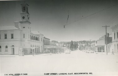
Photograph
This copy of a postcard from the Rose series depicts Camp Street looking East. This postcard is part of the Rose Series produced by Victorian photographer George Rose’s business, the Rose Stereograph Company. George Rose (1861-1942), is considered one of Australia's best photographers of the late 19th and early 20th centuries. The Rose Stereograph Company was founded in 1880 and became famous for producing stereographs, or stereoviews, which gave the illusion of being in 3D when seen through a hand-held viewer, a big craze of the era. As stereographs lost popularity in the 1920s, Rose switched to production of postcards and decorative cards, and he and the photographers who followed took thousands of scenes around Victoria as well as interstate that became iconic images of Australian life.Black and white photograph (copy) on gloss photographic paper.Obverse: THE ROSE SERIES P.3459 COPYRIGHT CAMP STREET, LOOKING EAST, BEECHWORTH, VIC Reverse: BMM7743 PH 149 1998.00059beechworth, rose series, camp street, burke museum, black and white