Showing 904 items matching "eltham east"
-
 Eltham District Historical Society Inc
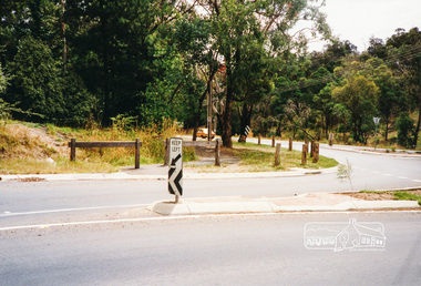
Photograph, Liz Pidgeon, Heritage Excursion; East of Eltham, 6 Sep 2014, 20 May 2017
... Heritage Excursion; East of Eltham, 6 Sep 2014...eltham east... - East of Eltham Walk In Newsletter No. 197, March 2011... - East of Eltham Walk In Newsletter No. 197, March 2011 ...Newsletter No. 218, September 2014 September Excursion - East of Eltham Walk In Newsletter No. 197, March 2011, there was a brief history of Crown Allotment 15 Section 5 Parish of Nillumbik (CA 15) a parcel of land of a quarter of a square mile extending from Eucalyptus Road to Reynolds Road at the eastern extremity of Eltham. From the 1940s it was known as Stokes orchard. In later years it has been subdivided for residential purposes but leaving significant areas as power line and water supply reserves and bushland reserves that are habitat for the threatened For our excursion on 6th September we intend to walk through CA 15 to a bushland reserve east of Reynolds Road. The walk will traverse the boundary between suburban Eltham and the non-urban areas to the south and east. This is a pleasant walk through residential areas and bushland. Along the way we will discuss the early and more recent history of CA 15 as well as local natural history and geology. This walk is about 3.5 km in length and will take 2 to 2.5 hours. It will start at 2pm at the corner of Eucalyptus Road, Pitt Street and Nyora Road.Born Digitaleltham east, eltham district historical society, heritage excursion, activities, nyora road, reynolds road, gum tree road reserve, diosma road, stokes orchard, eucalyptus road -
 Eltham District Historical Society Inc
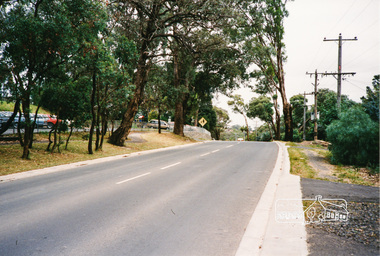
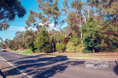
Photograph, Main Road, Research
... eltham east... and Eltham East; two showing the bike path looking tworads Eltham... melbourne eltham east research main road research warrandyte road ...Three colour photographs of Main Road between Research and Eltham East; two showing the bike path looking tworads Eltham and one viewed from Warrandyte Road near the roundabouteltham east, research, main road, research warrandyte road, warrandyte road, paths, bike paths -
 Eltham District Historical Society Inc
Slide, Floodwater, Ely Street, Eltham east of Falkiner Street, November 1971, 1971
... Floodwater, Ely Street, Eltham east of Falkiner Street..., Eltham east of Falkiner Street, November 1971 Slide Slide ...35 mm colour positive transparency Mount - Agfacolor Service (Blue)eltham, ely street, floods -
 Nillumbik Shire Council
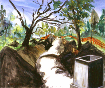
Painting: Jenni MITCHELL (b.1955 Melb, AUS), Research Creek, Eltham East
... Research Creek, Eltham East...Nillumbik Shire Council melbourne Research Creek, Eltham ... -
 Eltham District Historical Society Inc
Photograph, Grove Street, Eltham
... Colour photograph of Grove Street, Eltham near Eltham East..., Eltham near Eltham East School Grove Street, Eltham Photograph ...Colour photograph of Grove Street, Eltham near Eltham East Schoolgrove street, eltham -
 Eltham District Historical Society Inc
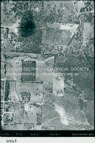
Photograph - Aerial Photograph, Landata, Eltham, Luck St; Bible St to Beard St, Dec. 1945
... Eltham East Primary School...Centred on present day Eltham East Primary School, east... melbourne Centred on present day Eltham East Primary School, east ...Centred on present day Eltham East Primary School, east of Main Rd along Luck St to Beard St Historic Aerial Imagery Source: Landata.vic.gov.au Aerial Photo Details: Project No :5 Project : MELBOURNE AND METROPOLITAN AREA PROJECT Run : 36 Frame : 60548 Date : 12/1945 Film Type : B/W Camera : EAG4 Flying Height : 10200 Scale : 6000 Film Number : 195 GDA2020 : 37°42'46"S, 145°09'18"E MGA2020 : 337371, 5824456 (55) Melways : 22 A4 (ed. 42)aerial photo, eltham, arthur street, beard street, bible street, eltham east primary school, frank street, henry street, luck street, stanley avenue, wycliffe crescent, neil webster collection -
 Eltham District Historical Society Inc
Photograph - Aerial Photograph, Landata, Eltham, Main Road; Henry St to Bellevue Rd, Dec. 1945
... Eltham East Primary School...Eltham, Main Road; Henry St to Bellevue Rd, and east along... melbourne Eltham, Main Road; Henry St to Bellevue Rd, and east along ...Eltham, Main Road; Henry St to Bellevue Rd, and east along Luck St to present day Eltham East School Historic Aerial Imagery Source: Landata.vic.gov.au Aerial Photo Details: Project No :5 Project : MELBOURNE AND METROPOLITAN AREA PROJECT Run : 36 Frame : 60549 Date : 12/1945 Film Type : B/W Camera : EAG4 Flying Height : 10200 Scale : 6000 Film Number : 228 GDA2020 : 37°42'45"S, 145°08'59"E MGA2020 : 336903, 5824465 (55) Melways : 21 K4 (ed. 42)aerial photo, arthur street, bellevue road, bible street, diamond street, dudley street, elsa court, eltham, eltham east primary school, gahan house, henry street, livingstone road, luck street, main road, pryor street, neil webster collection -
 Eltham District Historical Society Inc
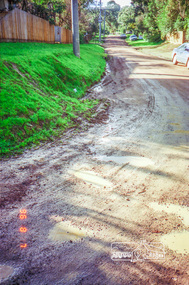
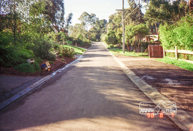
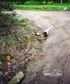
Photograph, Road surface conditions around Eltham: Looking east along Franklin Street from intersection with Bible Street, 7 Aug 1996, 1996
... Road surface conditions around Eltham: Looking east along... conditions around Eltham: Looking east along Franklin Street from ...Shows sections of Franklin, John and Napoleon streets were still unmade as of late 1996 and the condition of those roads with potholes at the intersections with Bible Street.Reflects on the changing nature of the local street-scape and housesRoll of 35mm colour negative film, 7 stripsKodak Gold 100-5eltham, napoleon street, bible street, franklin street, john street -
 Eltham District Historical Society Inc
Photograph, Road surface conditions around Eltham: Looking east along John Street at the intersection with Bible Street, 7 Aug 1996, 1996
... Road surface conditions around Eltham: Looking east along... conditions around Eltham: Looking east along John Street ...Shows sections of Franklin, John and Napoleon streets were still unmade as of late 1996 and the condition of those roads with potholes at the intersections with Bible Street.Reflects on the changing nature of the local street-scape and housesRoll of 35mm colour negative film, 7 stripsKodak Gold 100-5eltham, napoleon street, bible street, franklin street, john street -
 Eltham District Historical Society Inc
Photograph, Marjorie North, Brougham Street, Eltham looking east, 1985-1986, 1986
... Brougham Street, Eltham looking east, 1985-1986... Street, Eltham looking east, 1985-1986 Photograph Marjorie North ...Negatives supplied by Marjorie North 1 July 1986 for Montmorency France albumRoll of 35mm colour negative film, 4 of 6 stripsKodak CP 100 5094brougham street, eltham, floods -
 Eltham District Historical Society Inc
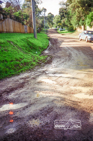
Photograph, Road surface conditions around Eltham: Looking east along Franklin Street adjacent to No. 131, 7 Aug 1996, 1996
... Road surface conditions around Eltham: Looking east along... conditions around Eltham: Looking east along Franklin Street adjacent ...Shows sections of Franklin, John and Napoleon streets were still unmade as of late 1996 and the condition of those roads with potholes at the intersections with Bible Street.Reflects on the changing nature of the local street-scape and housesRoll of 35mm colour negative film, 7 stripsKodak Gold 100-5eltham, napoleon street, bible street, franklin street, john street -
 Eltham District Historical Society Inc
Photograph, Brougham Street Eltham looking east to Susan Street
... Brougham Street Eltham looking east to Susan Street... of Brougham Street factory area Brougham Street Eltham looking east ...Colour photograph of Brougham Street factory areabrougham street, eltham, susan street -
 Eltham District Historical Society Inc
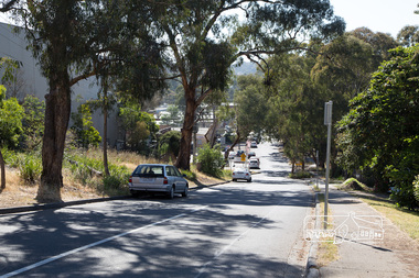
Photograph, Peter Pidgeon, Brougham Street, Eltham, looking east from intersection with Bolton Street, 13 November 2017, 13/11/2017
... Brougham Street, Eltham, looking east from intersection... Brougham Street, Eltham, looking east from intersection with Bolton ...North bound lane closure. Born Digitalbolton street, bolton street upgrade, eltham, streets, brougham street, southernwood -
 Eltham District Historical Society Inc
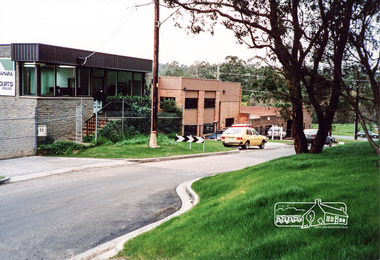
Photograph, Main Road, Eltham looking east towards Bolton Street (south), c.May 2001
... Main Road, Eltham looking east towards Bolton Street (south)...Eltham District Historical Society Inc 728 Main Rd Eltham ...Roll of 35mm colour negative film, 7 stripsAgfa HDC 200 plus-2eltham, streets, main road, bolton street -
 Eltham District Historical Society Inc
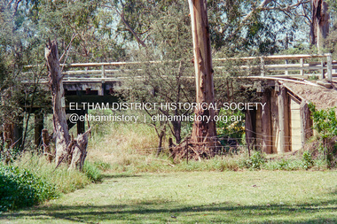
Negative - Photograph, The old Wattletree Road bridge, Eltham on east side of Diamond Creek, 1998c
... The old Wattletree Road bridge, Eltham on east side of... colour print The old Wattletree Road bridge, Eltham on east side ...Viewed from the backyard of the Bakos family residence, 107 Railway Parade Eltham (formerly 137 Railway Parade Eltham) looking north.Roll of 35mm colour negative film, 8 strips and associated 10 x 15 cm colour printKodak Gold 100-5wattletree road, bakos residence, bridge, eltham, railway parade, wattletree road bridge -
 Eltham District Historical Society Inc
Film - Video (VHS), Nillumbik Shire Council, The Nillumbik Story, 1996
... Eltham East Primary School... downstream flowing into the Yarra. Eltham East Primary School Band... downstream flowing into the Yarra. Eltham East Primary School Band ...PART 1 – NILLUMBIK (00:00-07:17) Opening features various scenes around Nillumbik Shire. For 40,000 years Nillumbik was the home of the Wurundjeri people. Robert Hoddle gave the district its name. Jock Ryan, then president of Nillumbik Historical Society discusses the names Nillumbik and Diamond Creek. In the late 1830s white occupation began with gold found in Warrandyte in 1851 and 12 years later at Diamond Creek -the Diamond Reef which led to the Caledonian gold rush. Jock Ryan discusses the Diamond Creek mine, which was thriving until it burnt out in 1915. Large numbers of workmen moved into area in late 1870s to construct the Maroondah Aqueduct. With growing population of Melbourne, the nearby Yan Yean system had severely disrupted the flow of the Plenty River, forcing the closure of three flour mills there. The aqueduct came to the rescue carrying water 66km from Healesville to Preston. When the Diamond Creek gold mine burnt down the local economy suffered but fruit growing industry had already been established and Diamond Creek became a thriving fruit growing centre. Interview with Jack Powell, a long-time fruiterer at St Andrews market, his family had lived in the area for a hundred years, 3 to 4 generations, “a lot of hard work”. By the time the railway arrived fruit growing was no longer competitive. The railway brought the city closer and day trippers. The Green Wedge separates the shire from the more densely developed neighbours such as Whittlesea, Doncaster, Templestowe, Bulleen and Greensborough. Population at the time (1996) was 19,000 but links to the past remain strong. Mudbrick houses along the Heritage Trail The saving of Shillinglaw Cottage from demolition in 1963 and relocation brick by brick. PART 2 – ENVIRONMENT (07:18-14:44) Peter Brock (with Bev Brock in background) at St Andrews market discusses his childhood growing up in the district and the environment and the values it instilled upon him and his own family. The Brocks have been in the district since the 1860s. Nillumbik Shire responsible for managing three catchment areas; Diamond Creek, Arthurs Creek and Watsons Creek. Follows the course of the Diamond Creek commencing in Kinglake through the district to its confluence with the Yarra River at Eltham at Eltham Lower Park. Highlights Eltham Lower Park community revegetation program and the newly constructed (1996) viewing platform built of new and recycled timbers at the confluence of the Diamond Creek and Yarra River. Also featured are outdoor recreation on the river and at Eltham Lower Park including the Diamond Valley miniature railway. Sugarloaf reservoir and recreational activities and fishing. Aerial view of Memorial Park and Shire of Eltham War Memorial tower at Garden Hill, Kangaroo Ground. Significant tourism opportunities for the shire with 3 million potential day-trippers in metropolitan Melbourne. Council and community working together to find a way to promote the shires natural and artistic assets. At Arthurs Creek, the Brock family and neighbours working together to take care of their waterway. Peter Brock’s uncle, Sandy Brock talks about environmental management and the Arthurs Creek Landcare group and actions to eradicate blackberry problem. Having previously planted Cypress rows they are replacing them with indigenous species to improve the water supply, keeping cattle out of the creek bed to improve the quality downstream flowing into the Yarra. Eltham East Primary School Band playing “All things bright and beautiful” merges into scenes of the bushland sanctuary set aside by the school in 1980 with unidentified teacher discusses the sanctuary and their education program and school children’s comments. Plight of a family of Wedgetail eagles nesting in the path of a developer’s bulldozer at North Warrandyte and actions to save their nesting areas. PART 3 – ARTS (14:45-22:00) Arts and Jazz festival at Montsalvat featuring interviews with Sigmund Jorgensen discussing Montsalvat and its principles. Also Matcham Skipper. Clifton Pugh’s funeral at Montsalvat and his legacy at Dunmoochin near Cottlesbridge with artists in residence, at the time, Chicago artist Charles Reddington who discusses the benefits of the experience. An unidentified female artist also talks about the program and why people are drawn to the area. Unidentified man on street talking about the amount of talent in the area, artists, poets, musicians, authors. Artist Ming Mackay (1918-2009) interviewed talking about the people she mixes with on “the Hill”. Works of local artists are displayed Eltham Library Community Gallery and Wiregrass gallery with a new coffee shop at the Wiregrass making it an even more popular destination. Music at St Andrews Hotel (may be a little bit country) and the Saturday market where likely to hear anything. Sellers and patrons at the market asked about what attracts them to the market and where they came from. Scenes of poets/authors giving readings. CREDITS Music by John Greenfield from the CD Sweet Rain “The Snow Tree”, Uncle Music UNC 2001 Cameras - David Mirabella and Peter Farragher Editor – Olwyn Jones Written and Produced by Jason Cameron A Jason Cameron Proction for Nillumbik ShireProvides a record of the relatively newly created Shire of Nillumbik at the time and the features and attactions of the shire in its people arts, culture and environmentVHS Cassette (five copies) DVD (one copy) Converted to MP4 file format 0:22:00, 1.60GBvideo recording, arthurs creek, arthurs creek landcare group, artists, artists in residence, arts, arts festival, authors, blackberry, brock family, bulldozer, bulleen, bushland sanctuary, caledonian gold rush, charles reddington, clifton pugh, cottlesbridge, cypress rows, developer, diamond creek, diamond creek mine, diamond reef, diamond valley miniature railway, doncaster, dunmoochin, education program, eeps, eltham, eltham east primary school, eltham east primary school band, eltham library community gallery, eltham lower park, environment, fishing, flour mill, fruit growing, fruiterer, garden hill, gold mining, green wedge, greensborough, heritage trail, hurstbridge railway line, jazz festival, jock ryan, kangaroo ground, kangaroo ground tower, kinglake, maroondah aqueduct, matcham skipper, memorial park, ming mackay (1918-2009), montsalvat, mudbrick houses, music, musicians, nesting area, nillumbik historical society, nillumbik shire, north warrandyte, old timer, orchards, peter brock, plenty river, poets, population, recreation, recreational activities, revegetation, robert hoddle, sandy brock, shillinglaw cottage, shire of eltham war memorial, sigmund jorgensen, st andrews hotel, st andrews market, sugarloaf reservoir, templestowe, the hill, tourism, viewing platform, warrandyte, water catchment area, watsons creek, wedgetail eagle, whittlesea, wiregrass gallery, wurundjeri, yarra river, jack powell -
 Eltham District Historical Society Inc
Film - Video (VHS), Dynavision Video Production, 1994 Eltham Festival, 11 Nov 1994
... eltham east primary school... East Primary School, Eltham Fire Brigade, Eltham Junior... East Primary School, Eltham Fire Brigade, Eltham Junior ...20th Eltham Community Festival and last under the auspices of the Shire of Eltham. The Grand Parade focussing on the theme "Echoes of Eltham - Celebrating the visions of Eltrham from the past and into the future" was headed by Jock Read on his horse Lofty who had been filmed in an Anzac Day Parade on an earlier horse which had featured in the television show Matlock. The parade travelled north along Main Street to just past the Post Office then back south to Panther Place. Parade participants included 1st Eltham Brownies, 1st Eltham Venturers, 2nd Eltham Sea Scouts, 2nd Eltham Venturers, 3rd Eltham Brownies, Australian Democrats, Briar Hill Primary School, Circus Chaos, Country Fire Authority, Diamond Valley People for Disarmament, Diamond Valley Railway, Eltham Community Health Centre, Eltham District Horse and Pony Club, Eltham East Primary School, Eltham Fire Brigade, Eltham Junior Football Club (Panthers), Eltham Little Theatre, Eltham North Primary School, Eltham Playhouse Co-op, Eltham Pre-school, Eltham Roller Skating Club, Eltham South Pre-School Centre, Eltham Steam and Stationary Engine Society, Greenhills Neighbourhood House, Heidelberg Municipal Band, Hurstbridge Learning Co-op, Jocklebeary Farm, Kangaroo Ground Primary School, Learning Co-op Primary School, Lower Plenty Primary School, Main Road, Montmorency Gardening Club, Montmorency South Primary School, North Warrandyte Fire Brigade, Plenty Valley 88.6 FM, Research Pre-school, Research Primary School, Ron Sampson, Salvation Army Band (Briar Hill), Sherbourne Primary School, Shire of Eltham, State Emergency Service (Eltham) and Woodridge Pre-school. The parade commentary was provided by Plenty Valley FM 88.6 with guest commentator, Shire President Cr. John Graves. Following the parade is video footage from a helicopter of Alistair Knox Park, displays along Main Road and activities in Alistair Knox Park and the Rugby oval along with stationary engines, helicopter joyrides, Eltham People's Choir, music entertainment. Scenes also from the Diamond Valley Railway at Eltham Lower Park and finishing with the fireworks display. At the end of the video is a promotional video for Dynavision Video Production, a local video production company that produced the video and Diamond Photos (Kodak Express). One of the highlights of the festival was a tree planting ceremony in Alistair Knox Park to celebrate 123 years of the Shire of Eltham led by Shire President Cr. John Graves and representatives of the Wurrundjeri, traditional land owners of the area.VHS Video cassette (poor quality) Converted to MP4 file format 45:01, 535MB DVD copy of VHS cassette (better quality)1st eltham brownies, 1st eltham venturers, 2nd eltham sea scouts, 2nd eltham venturers, 3rd eltham brownies, 1994, aerial photographs, alistair knox park, arthur street, australian democrats, briar hill primary school, circus chaos, country fire authority, diamond valley people for disarmament, diamond valley railway, eltham community health centre, eltham district horse and pony club, eltham east primary school, eltham festival, eltham fire brigade, eltham junior football club (panthers), eltham little theatre, eltham lower park, eltham north primary school, eltham people's choir, eltham playhouse co-op, eltham pre-school, eltham roller skating club, eltham south pre-school centre, eltham steam and stationary engine society, grand parade, greenhills neighbourhood house, heidelberg municipal band, hurstbridge learning co-op, jock read, jocklebeary farm, john graves, kangaroo ground primary school, learning co-op primary school, lofty (horse), lower plenty primary school, main road, matlock police (tv show), montmorency gardening club, montmorency south primary school, nicholaus lauder estate, north warrandyte fire brigade, plenty valley 88.6 fm, research pre-school, research primary school, ron sampson, salvation army band (briar hill), sherbourne primary school, shire of eltham, state emergency service (eltham), video recording, woodridge pre-school -
 Eltham District Historical Society Inc
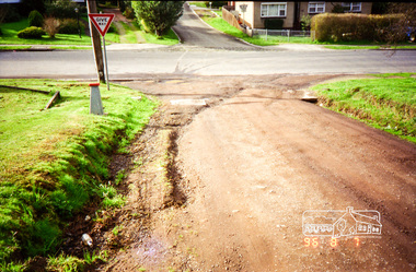
Photograph, Road surface conditions around Eltham: Napoleon Street at Bible Street, Eltham, looking south-east, 7 Aug 1996, 1996
... Bible Street, Eltham, looking south-east, 7 Aug 1996...Eltham District Historical Society Inc 728 Main Rd Eltham ...Shows sections of Franklin, John and Napoleon streets were still unmade as of late 1996 and the condition of those roads with potholes at the intersections with Bible Street.Reflects on the changing nature of the local street-scape and housesRoll of 35mm colour negative film, 7 stripsKodak Gold 100-5eltham, napoleon street, bible street, franklin street, john street