Showing 165 items
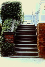
matching entrance design
-
 Bendigo Historical Society Inc.
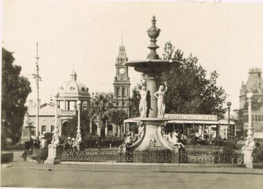
Photograph - DAWN SMITH COLLECTION: PHOTOS OF BENDIGO, c1929
Black & White Photograph Alexandra Fountain, Bendigo Souvenir Tourism Set Rose Collection Series c1929. Alexandra Fountain is regarded as one of Bendigo, Victoria, Australia's most prominent landmarks and monuments. The fountain is located in Bendigo's "Charing Cross", the intersection of View Street and Pall Mall. Haring Cross effectively stands at the centre of the city and is one of Bendigo's busiest and most prominent intersections. The fountain stands opposite to the main entrance of Rosalind Park. Alexandra Fountain was funded from the proceeds of the Bendigo Juvenile Industrial Exhibition (1879), a £500 gift from George Lansell and a further £700 from the Sandhurst City Council (now the City of Greater Bendigo). The fountain was designed by W. C. Vahland,] a local architect responsible for some of the cities most prominent buildings.The fountain was named in honour of Alexandra, Princess of Wales and the grand opening (5 July 1881) was attended by her sons Prince Albert and Prince George.bendigo, tourism, alexandra fountain bendigo -
 Bendigo Historical Society Inc.
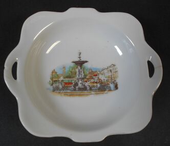
Memorabilia - Alexandra Fountain Souvenir Plate
Alexandra Fountain is a fountain in the Australian city of Bendigo, Victoria. It is regarded as one of the city's most prominent landmarks and monuments The fountain is located in Bendigo's Charing Cross area at the intersection of View Street and Pall Mall. Charing Cross effectively stands at the centre of the city and is one of Bendigo's busiest and most prominent intersections. The fountain stands opposite the main entrance of Rosalind Park. Alexandra Fountain was funded from the proceeds of the Bendigo Juvenile Industrial Exhibition (1879), a £500 gift from George Lansell and a further £700 from the Sandhurst City Council (now the City of Greater Bendigo). The fountain was designed by William Vahland (1828–1915), a local architect responsible for some of the city's most prominent buildings. The fountain was named in honour of Alexandra, Princess of Wales. Its grand opening on 5 July 1881 was attended by her sons Prince Albert and Prince George.White shallow bowl with transfer of Alexandra Fountain in centreMade in Japanalexandra fountain, bendigo landmarks -
 Bendigo Historical Society Inc.
Book - MERLE HALL COLLECTION: ROSALIND PARK CREATIVE VILLAGE BENDIGO PROJECT BOOK, 1995
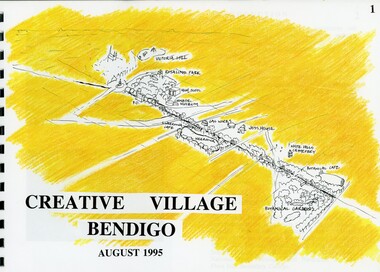
... Golden Beacon Design Concept Bridge Beacon Entrance to Linear..., The Design Team, Acknowledgement Project Brief Map of Linked Park ...Merle Hall Collection: Rosalind Park Creative Village Bendigo Project Book. August 1995 Book contains a description, aims of the programme and a linking plan. 35 Pages: Cover Intoduction, The Design Team, Acknowledgement Project Brief Map of Linked Park The Linking Plan described Linking plan graphic Golden Beacon Design Concept Bridge Beacon Entrance to Linear Park Gasworks Café Pavillion Gasworks layout plan Golden Beacons Concept Botanical Gardens Café Botanical Gardens layout plan Victoria Hill Interpretation Centre Victoria Hill layout Victoria Hill plan Victoria Hill continued Victoria Hill continued Rosalind Park Lookout Method 3D Road Map 3D Road Map Continued Implementation Community Participation Oppurtunities, Mosaic Works Appropriate sites Appropriate sites continued Consultaion Summary and Issues Ideas Areas for further consideration Graphic The Design Team - Grant Fink, Jane Marriott, Laszo Biro, James Brearley Graphic Layoutbook -
 Kew Historical Society Inc
Photograph - 2 Young Street, Kew, Paramount Photos, 1920s
Subdivision plans are historically important documents used as evidence of the growth of suburbs in Australia. They frequently provide information about when the land was sold on which a built structure was subsequently constructed as well as evidence relating to surveyors and real estate and financial agents. The numerous subdivision plans in the Kew Historical Society's collection represent working documents, ranging from the initial sketches made in planning a subdivision to printed plans on which auctioneers or agents listed the prices for which individual lots were sold. In a number of cases, the reverse of a subdivision plan in the collection includes a photograph of a house that was also for sale by the agent. These photographs provide significant heritage information relating house design and decoration, fencing and household gardens.A prepossessing, large home constructed in the Arts and Crafts style. Located on the banks of the Yarra at 2 Young Street, Kew overlooking the factories of Richmond, the design of the house takes account of the gradient with the addition of a level below the front entrance. The elegant roof includes a number of projecting gables and dormers. The gables are typically half-timbered and rendered. In addition to the asymmetrically placed portico, there are at least two open verandas, supported by timber pillars and with roofs that reflect the overall pitch of the roof of the housereal estate photographs, 2 young street - kew -
 Kew Historical Society Inc
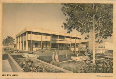
Drawing, AK Lines, Macfarlane & Marshall, Kew Civic Centre, c.1970
The Kew Civic Centre (A K Lines, MacFarlane & Marshall, 1972) was built next to the Kew Civic Hall (A C Leith & Bartlett, 1960) on the site of the former mansion Ordsall (later renamed South Esk). Whereas the entrance to the Civic Hall was positioned off Civic Drive, the main entrance to the Civic Centre faced Cotham Road, as shown in the undated perspective drawing of the proposed building. The Civic Hall was used for public functions and performances, while the Civic Centre was used for civic offices. It also contained the Council Chamber. The building opened in 1972, following the relocation of the councillors and council officers from the former Town Hall in Walpole Street (now a Woolworth's supermarket). Following the amalgamation of the former City of Kew into the City of Boroondara in 1994, the Civic Centre was sold to Trinity Grammar School. The exterior of the Centre has been modified by Trinity Grammar.A report for Heritage Victoria (date) describes how two architectural firms dominated the designs for new civic buildings in Victoria during the post war period. The report claims that: "An interesting sub-theme in the erection of post-war municipal offices in Victoria is that a considerable proportion were designed by the same three or four Melbourne-based architectural firms, who established themselves as the leading specialists in this type of work. The two most prolific firms in this regard were A K Lines, MacFarlane & Marshall, and A C Leith & Bartlett; both, in fact, had made names for themselves as designers of local government offices prior to the Second World War. Lines' office, for example had designed the Eltham Shire Offices in 1941, while Leith's firm had been responsible for the celebrated Heidelberg Town Hall in 1937). Both practices parleyed this early experience into a lucrative post-war career, designing numerous municipals offices well into the 1970s." (Survey of Post-War Built Heritage in Victoria, Built Heritage Pty Ltd, 2010.) The perspective drawing importantly captures the original design and function of the exterior of the building and its public entrance.Hand-coloured perspective sketch of the new Kew Civic Centre, completed in 1972 to designs by A K Lines, MacFarlane & Marshall; and located on the corner of Charles Street and Cotham Road, Kew. The sketch represents the front elevation of the building and its relation to the preexisting Kew Civic Hall at right. The three storey building features strong vertical concrete buttresses that extend across the three levels. KEW CIVIC CENTRE / A K LINES, MACFARLANE & MARSHALLkew civic centre, a.k. lines, macfarlane & marshall, architectural drawings, civic buildings -- kew (vic.), town hall -- kew (vic) -
 Kew Historical Society Inc
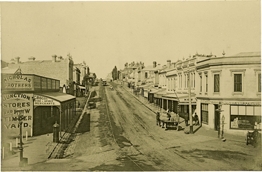
Photograph, J F C Farquhar, High Street, Kew, 1891
At the beginning of the 1890s, the Kew businessman and Town Councillor, Henry Kellett, commissioned J.F.C. Farquhar to photograph scenes of Kew. These scenes included panoramas as well as pastoral scenes. The resulting set of twelve photographs was assembled in an album, Kew Where We Live, from which customers could select images for purchase.The preamble to the album describes that the photographs used the ‘argentic bromide’ process, now more commonly known as the gelatine silver process. This form of dry plate photography allowed for the negatives to be kept for weeks before processing, hence its value in landscape photography. The resulting images were considered to be finely grained and everlasting. Evidence of the success of Henry Kellett’s venture can be seen today, in that some of the photographs are held in national collections.It is believed that the Kew Historical Society’s copy of the Kellett album is unique and that the photographs in the book were the first copies taken from the original plates. It is the first and most important series of images produced about Kew. The individual images have proved essential in identifying buildings and places of heritage value in the district.In 1891, High Street was the centre of commercial activity in the Borough of Kew. It was unpaved and edged with deep bluestone gutters, which were designed to channel the significant flow of storm water down the hill to and beyond the Junction. On either side of the entrance to the shopping strip are two cast iron gas lamps that provided the only public street lighting before the Post Office was reached. Most shops, including the Nicholas Brothers’ Junction Store featured cast iron verandas. Further up the hill, Dougherty’s Greyhound Hotel was by this stage a local institution. Apart from the horse-drawn tram, the main form of personal and commercial transport in this period remained the horse, horse and cart, or buggy.The panoramic view predates the widening of High Street in the 20th century, and thus includes the original alignment of buildings on the south side. These included Henry Kellett’s shop.High Street, Kewkew illustrated, kew where we live, photographic books, henry kellett, high street - kew (vic) -
 Kew Historical Society Inc
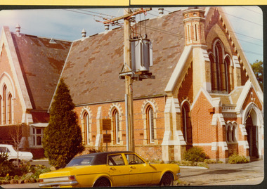
Photograph - Former Congregational Church, Walpole Street, Stewart West, 1977
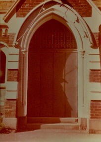
The site of the former Kew Congregational Church was the earliest 'built' place of religion in Kew. An earlier building by Charles Vickers was replaced by a new brick church designed by Albert Purchas. Following the creation of the Uniting Church, the church at 30 Walpole Street was declared redundant and demolished to make way for the Bodalla Nursing Home (itself later demolished).Colour print positive of the former Congregational Church in Walpole Street, Kew. A side on view of the red brick and concrete renders building showing the small steeple and the front entrance."Oldest church in Kew. Taken Oct 1977. Formerly Congregational church"churches -- kew (vic), congregational churches, walpole street -- kew (vic), albert purchas -
 Kew Historical Society Inc
Photograph - Former Congregational Church, Walpole Street, Stewart West, 1977
The site of the former Kew Congregational Church was the earliest 'built' place of religion in Kew. An earlier building by Charles Vickers was replaced by a new brick church designed by Albert Purchas. Following the creation of the Uniting Church, the church at 30 Walpole Street was declared redundant and demolished to make way for the Bodalla Nursing Home (itself later demolished).Colour print positive of the former Congregational Church in Walpole Street, Kew. The front of the polychrome brick building showing the small steeple and the front entrance."Oldest church in Kew. Victoria. Taken Oct '77. Formerly Congregational Church"churches -- kew (vic), congregational churches, walpole street -- kew (vic), albert purchas -
 Kew Historical Society Inc
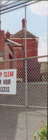
Photograph - Former Kew Police Station : Parking lot, 1996
A civic campaign for new public offices developed in Kew in the 1880s. After much deliberation, the location chosen was the junction of Bulleen and Cotham Roads. The buildings were designed by George Watson and John Henry Harvey, architects within the Department of Public Works (Victoria). Building was commenced in 1887, and after one year, the buildings were opened. The Post Office was transferred to the new Commonwealth Government in 1901. The Police Station and Court House, sold by the Victorian Government to the City of Boroondara in 2007, are now a community cultural centre and performing arts venue.The buildings were listed on the Victorian Heritage Register Register (HO885) in 1991. They are historically and architecturally significant to the State of Victoria because Watson and Harvey's designs exhibit diversity in integrating civil offices, they accommodate the apex of road junctions, and they demonstrate a departure from the contemporaneously favoured High Victorian Classical to the Queen Anne style in the design of civic buildings.View through the old wire gates into the parking lot behind the former Kew Police Station and Court House. This was the entrance from Cotham Road with which supplies, prisoners, and police cars would enter.kew court house, public offices -- kew (vic), kew police station -
 Kew Historical Society Inc
Photograph - Former Kew Post Office : Cotham Road frontage, 1996
A civic campaign for new public offices developed in Kew in the 1880s. After much deliberation, the location chosen was the junction of Bulleen and Cotham Roads. The buildings were designed by George Watson and John Henry Harvey, architects within the Department of Public Works (Victoria). Building was commenced in 1887, and after one year, the buildings were opened. The Post Office was transferred to the new Commonwealth Government in 1901. The Police Station and Court House, sold by the Victorian Government to the City of Boroondara in 2007, are now a community cultural centre and performing arts venue.The buildings were listed on the Victorian Heritage Register Register (HO885) in 1991. They are historically and architecturally significant to the State of Victoria because Watson and Harvey's designs exhibit diversity in integrating civil offices, they accommodate the apex of road junctions, and they demonstrate a departure from the contemporaneously favoured High Victorian Classical to the Queen Anne style in the design of civic buildings.Panoramic photograph of the entrances from Cotham Road to the Kew Post Office, Court House and Police Station. At centre front is the public toilet block, erected in the twentieth century by the City of Kew to designs by Rowland Chipperfield.kew court house, public offices -- kew (vic), kew police station, kew post office, cotham road -- kew (vic.) -
 Kew Historical Society Inc
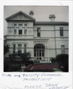
Photograph - 'Otira', 73 Walpole Street, 1978
Sanderson P (1988): '73 Walpole Street (Kew), 'Otira'. Built 1887. Original use - Residence. Architect - Crouch. Henry Berry, a noted philanthropist and salt merchant of Melbourne, was the original owner of this two-storey, boom-period house. Berry occupied the residence until his death in 1923 while in February the following year, the property was auctioned. Subsequently purchased by the Methodist Church for use as a training college for missionaries, a number of additions and alterations were made at that stage including a memorial chapel that was built on the property in 1957.' Otira is now a private residence. Original colour positive photograph (polaroid) of 'Otira', 73 Walpole Street, Kew, taken in 1978 by students in Form 3R at Trinity Grammar School as part of a project. The view in the photograph is of the front of the house, minus the first floor verandah that had been removed some decades before and preceding the reinstatement of the verandah sometime after 1988. Prue Sanderson, in the City of Kew Urban Conservation Study, Vol.2 (1988) stated that: 'The house originally had a fine cast iron verandah to two facades, however despite its removal, it remains as a most preposessing structure, The small cast iron perch is not original. Overall the design is in Italianate styling and the walls are clad in render, with extremely fine incised medallions in the render at both levels. The treatment of the tripartite windows with rounded upper corners is also atypical and is repeated in the joinery of the front entrance.'"Photo one / Trinity Grammar Project 1978 / Form 3R / "Otira" Walpole St"otira - 73 walpole street, henry berry, historic houses -- kew (vic.), trinity grammar school, melbourne architects -- crouch -
 Kew Historical Society Inc
Plan - Subdivision Plan, Tregarron Estate, Kew, c.1929
Pru Sanderson, in her groundbreaking ‘City of Kew Urban Conservation Study : Volume 2 - Development History’ (1988), summarised the periods of urban development and subdivisions of land in Kew. The periods that she identified included 1845-1880, 1880-1893, 1893-1921, 1921-1933, 1933-1943, and Post-War Development. These periods were selected as they represented periods of rapid growth or decline in urban development. An obvious starting point for Sanderson’s groupings involved population growth and the associated economic cycles. These cycles also highlighted urban expansion onto land that was predominantly rural, although in other cases it represented the decline and breakup of large estates. A number of the plans in the Kew Historical Society’s collection can also be found in other collections, such as those of the State Library of Victoria and the Boroondara Library Service. A number are however unique to the collection.Subdivision plans are historically important documents used as evidence of the growth of suburbs in Australia. They frequently provide information about when the land was sold on which a built structure was subsequently constructed as well as evidence relating to surveyors and real estate and financial agents. The numerous subdivision plans in the Kew Historical Society's collection represent working documents, ranging from the initial sketches made in planning a subdivision to printed plans on which auctioneers or agents listed the prices for which individual lots were sold. In a number of cases, the reverse of a subdivision plan in the collection includes a photograph of a house that was also for sale by the agent. These photographs provide significant heritage information relating house design and decoration, fencing and household gardens.In January 1929, the Kew City Council called for tenders to construct Tregarron Avenue. The subdivision of the Tregarron Estate in Kew was for 11 lots bordering Tregarron Avenue and its entrance from Burke Road. The plan includes annotations that indicate the measurement of each block and the placement of the drainage and sewerage easements. This plan is interesting for a number of factors. The house blocks today have different street numbers, some blocks were to be further subdivided, and at the time of the subdivision, alterations were still being made to the extent of lots offered; lots 2 and 3 on the plan were subdivided and reoriented.subdivision plans - kew, tregarron estate, tregarron avenue -- kew (vic.), burke road -- kew (vic.) -
 Kew Historical Society Inc
Plan - Subdivision Plan, Jas R Mathers Son & McMillan, Macartney Estate, East Kew, c. 1925
Pru Sanderson, in her groundbreaking ‘City of Kew Urban Conservation Study : Volume 2 - Development History’ (1988), summarised the periods of urban development and subdivisions of land in Kew. The periods that she identified included 1845-1880, 1880-1893, 1893-1921, 1921-1933, 1933-1943, and Post-War Development. These periods were selected as they represented periods of rapid growth or decline in urban development. An obvious starting point for Sanderson’s groupings involved population growth and the associated economic cycles. These cycles also highlighted urban expansion onto land that was predominantly rural, although in other cases it represented the decline and breakup of large estates. A number of the plans in the Kew Historical Society’s collection can also be found in other collections, such as those of the State Library of Victoria and the Boroondara Library Service. A number are however unique to the collection.Subdivision plans are historically important documents used as evidence of the growth of suburbs in Australia. They frequently provide information about when the land was sold on which a built structure was subsequently constructed as well as evidence relating to surveyors and real estate and financial agents. The numerous subdivision plans in the Kew Historical Society's collection represent working documents, ranging from the initial sketches made in planning a subdivision to printed plans on which auctioneers or agents listed the prices for which individual lots were sold. In a number of cases, the reverse of a subdivision plan in the collection includes a photograph of a house that was also for sale by the agent. These photographs provide significant heritage information relating house design and decoration, fencing and household gardens.The Macartney Estate subdivision advertised 21 lots for sale on either side of Macartney Street (now Macartney Avenue) and Evans Road in what was then designated as East Kew. Most of the houses shown on the south side of Macartney Street then, as now, have rear entrances on Mount Street, however a number of these blocks have since been further subdivided to allow for the building of new houses on the rear of a block. Brougham Place is marked on the plan but is now called Daniell Place."C"subdivision plans - east kew, macartney estate, macartney street, mount street, evans road, brougham place -
 Kew Historical Society Inc
Photograph - 'Tara Hall', Studley Park Road, 1890-1900
During construction, commentators described the house as being in the ‘Elizabethan style’. The architectural style of the exterior, with its innovatory use of red brick and Italian tiles was more influenced by American models. Edward George Kilburn, of Ellerker & Kilburn, designed Byram for the industrialist George Ramsden in 1888.This is an original small photograph of this historic Kew mansion with provenance by descent from the first owners of the house.The main entrance to Tara Hall (previously named Byram, Goathland and Lowan). The entrance, through a porte-cochère, was located on the east side of the house. Inscription reverse: KH-323 Tara Hall once stood on Studley Pk Road on vast landscaped gardens. Donated by Mr Peter Ramsden, 49 Kamilaroy Road, West Pymble 2073 N.S.W. Dec.1979."byram, tara hall, lowan, goathland, edward g. kilburn (architect), george ramsden -
 Kew Historical Society Inc
Photograph - Porte-cochere, 'Tara Hall', Studley Park Road, Marc Strizic (attrib), c.1960
'Lost Glories: a memorial to forgotten Australian buildings' was published by David Latta in 1986. It tells the story of a number of significant Australian buildings that had previously been demolished. A chapter in the book was devoted to Goathland, later known as Tara Hall. To supplement the text, he sourced photographs from a range of suppliers, chiefly the Royal Women's Hospital which had once owned Tara Hall, but had sold it in 1960. This is one of the photographs donated to KHS by the author. Porte-cochere, Tara Hall, circa 1957. The main entrance to Tara Hall (previously named Byram, Goathland and Lowan). The entrance, through a porte-cochère, was located on the side of the house facing east. During construction, commentators described the house as being in the ‘Elizabethan style’. The architectural style of the exterior, with its innovatory use of red brick and Italian tiles was more influenced by American models. Edward George Kilburn, of Ellerker & Kilburn, designed Byram for the industrialist George Ramsden in 1888. Typed inscription on reverse: "Goathland, also known as Tara Hall (Royal Women's Hospital, Melbourne)."goathland -- kew (vic), byram -- kew (vic), tara hall - kew (vic), studley park road -
 Kew Historical Society Inc
Photograph, J E & B L Rogers, New Approach to Cemetery Boroondara, 1950s
This work forms part of the collection assembled by the historian Dorothy Rogers, that was donated to the Kew Historical Society by her son John Rogers in 2015. The manuscripts, photographs, maps, and documents were sourced by her from both family and local collections or produced as references for her print publications. Many were directly used by Rogers in writing ‘Lovely Old Homes of Kew’ (1961) and 'A History of Kew' (1973), or the numerous articles on local history that she produced for suburban newspapers. Most of the photographs in the collection include detailed annotations in her hand.The Rogers Collection provides a comprehensive insight into the working habits of a historian in the 1960s and 1970s. Together it forms the largest privately-donated collection within the archives of the Kew Historical Society.Black and white photo of the entrance gates to the cemetery with the bell tower and surrounding buildings at the left. "New Approach to Cemetery Boroondara"boroondara general (kew) cemetery, cemetery design -- victoria -
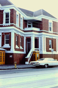
 Kew Historical Society Inc
Slide - Stairs: Kew Post Office, 1980
A civic campaign for new public offices developed in Kew in the 1880s. After much deliberation, the location chosen was the junction of Bulleen and Cotham Roads. The buildings were designed by George Watson and John Henry Harvey, architects within the Department of Public Works (Victoria). Building was commenced in 1887, and after one year, the buildings were opened. The Post Office was transferred to the new Commonwealth Government in 1901. The Police Station and Court House, sold by the Victorian Government to the City of Boroondara in 2007, are now a community cultural centre and performing arts venue.The buildings were listed on the Victorian Heritage Register Register (HO885) in 1991. They are historically and architecturally significant to the State of Victoria because Watson and Harvey's designs exhibit diversity in integrating civil offices, they accommodate the apex of road junctions, and they demonstrate a departure from the contemporaneously favoured High Victorian Classical to the Queen Anne style in the design of civic buildings. 35mm colour transparency of the stairs on the right side of the entrance to the Kew Post Office. The [former] post office is a significant example of the English Queen Anne Revival style. The photograph was taken as part of a series by Ralph Andrews (Department of Building, RMIT) in April 1980.kew post office, khs - slides, new public offices -- kew (vic.), architectural styles -- english queen anne revival -
 Kew Historical Society Inc
Slide - Cotham Road Facade: Kew Post Office, 1980
A civic campaign for new public offices developed in Kew in the 1880s. After much deliberation, the location chosen was the junction of Bulleen and Cotham Roads. The buildings were designed by George Watson and John Henry Harvey, architects within the Department of Public Works (Victoria). Building was commenced in 1887, and after one year, the buildings were opened. The Post Office was transferred to the new Commonwealth Government in 1901. The Police Station and Court House, sold by the Victorian Government to the City of Boroondara in 2007, are now a community cultural centre and performing arts venue.The buildings were listed on the Victorian Heritage Register Register (HO885) in 1991. They are historically and architecturally significant to the State of Victoria because Watson and Harvey's designs exhibit diversity in integrating civil offices, they accommodate the apex of road junctions, and they demonstrate a departure from the contemporaneously favoured High Victorian Classical to the Queen Anne style in the design of civic buildings. 35mm colour transparency of the secondary entrance, red brick walls, recessed balconies and painted and rendered architectural features of the Kew Post Office, facing Cotham Road. The [former] post office is a significant example of the English Queen Anne Revival style. The photograph was taken as part of a series by Ralph Andrews (Department of Building, RMIT) in April 1980.kew post office, khs - slides, new public offices -- kew (vic.), architectural styles -- english queen anne revival -
 Kew Historical Society Inc
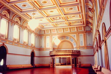
Slide - State Ballroom: Government House Victoria, John T Collins, 1979
Government House, Melbourne was constructed between 1972 and 1876 to a design of William Wardell. The interiors including the ballroom were created soon after the building's opening. The Victorian Heritage Register citation notes that the extravagant single storey State Ballroom occupies the entire south wing. The slide is significant as it represents the decoration and furnishings of the State Ball Room in 1979.One of six colour transparencies, purchased from John T Collins of interior and exterior views of Government House, Melbourne. This photograph (slide) is of the entrance to the State Ballroom."South Yarra Government House Ballroom J Collins 17-10-79"government house -- melbourne, victorian interiors, ballrooms -- melbourne (vic.), john t collins -
 Kew Historical Society Inc
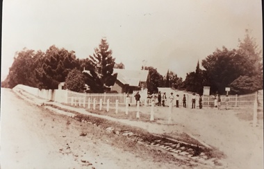
Photograph - Entrance to Boroondara General Cemetery
Boroondara Cemetery, established in 1858, is within an unusual triangular reserve bounded by High Street, Park Hill Road and Victoria Park, Kew. The caretaker's lodge and administrative office (1860 designed by Charles Vickers, additions, 1866-1899 by Albert Purchas) form a picturesque two-storey brick structure with a slate roof and clock tower. A rotunda or shelter (1890, Albert Purchas) is located in the centre of the cemetery: this has an octagonal hipped roof with fish scale slates and a decorative brick base with a tessellated floor and timber seating. The cemetery is surrounded by a 2.7 metre high ornamental red brick wall (1895-96, Albert Purchas) with some sections of vertical iron palisades between brick pillars. Albert Purchas was a prominent Melbourne architect who was the Secretary of the Melbourne General Cemetery from 1852 to 1907 and Chairman of the Boroondara Cemetery Board of Trustees from 1867 to 1909. He made a significant contribution to the design of the Boroondara Cemetery. (Source: Heritage Victoria)This photograph is one of the earliest known photographs of the cemetery, showing the early plantings and fences.Later print copy of an undated original photographic positive of the entrance to the Boroondara General (Kew) Cemetery. The Cemetery had been opened in 1855. This view is from Bulleen Road (now High Street) showing a group of 12 or 13 men standing in a line outside the entrance. At this time, the clocktower and high brick fence had not been constructed, but the trees have reached a substantial heightPencil inscription on reverse - "Boroondara Cemetery Entrance 1862"boroondara general (kew) cemetery, cemeteries -- melbourne (vic.) -
 Kew Historical Society Inc
Photograph - Entrance, Kew Congregational Church, Walpole Street, 1978
The site of the former Kew Congregational Church was the earliest 'built' place of religion in Kew. An earlier building by Charles Vickers was replaced by a new brick church designed by Albert Purchas. Following the creation of the Uniting Church, the church at 30 Walpole Street was declared redundant and demolished to make way for the Bodalla Nursing Home (itself later demolished).Faded colour photograph of an entrance door of the Kew Congregational Church in Walpole Street (Dem. 1978/9). The single door had an ornate iron grill above it. The door was set within a concrete stucco neo-Gothic arch surrounded by red brick work."KH-137 / Donated by H. Gielen / Former Congregational Church"kew congregational church, architects -- albert purchas, churches -- kew (vic.), walpole street -- kew (vic.), congregational churches -- melbourne (vic.) -
 Kew Historical Society Inc
Photograph - 'Raheen', 96 Studley Park Road
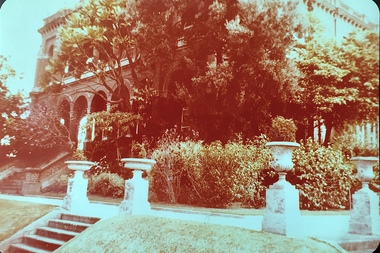
Raheen was constructed as a two-storey house in the Italianate style with a four-storey tower over the entrance and single-storey extension. It was designed in an asymmetric and arcaded form, and is built of red brick with cement render. The property retains its garden layout, including an Italianate garden, outbuildings, fence and gates, and internal features including the original stairwell, library, ballroom and cast iron tower stairs. (source VHD)View of the upper and lower eastern loggias of 'Raheen' at 96 Studley Park Road, Kew from the eastern garden. The colour photo shows the pedestals and urns above the steps and the plantings in the garden c.1980. raheen -- 96 studley park road -- kew (vic.), historic houses -- studley park, mansions -- kew (vic.) -
 Williamstown Botanic Gardens- Hobsons Bay City Council
Postcard - Williamstown Botanic Gardens, c1900-1910
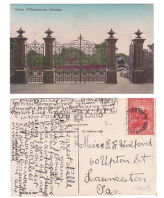
The original postcards in this series (2013.002 to 2013.018) were generously loaned to Williamstown Botanic Gardens by a private collector for copying. The cast iron gates (manufactured in Glasgow) introduced at the North West entrance in 1907. The gates were purchased from ‘Fairlie” corner of Acland and Anderson Streets, South Yarra at the cost of 72 pounds and cost 60 pounds to install. They had originally cost the owners of ‘Fairlie’ 1200 pounds. The postcards are evidence of the interest the gardens held as a subject for postcard publishers. The text and images provide a snapshot into fashions, social interests and concerns of the time. The professionally produced images provide a pictorial history of Gardens including changing planting styles, various structures and features of the Gardens eg the aviary, cannons, the fountain, the second Curator’s Lodge and gates. The images offer an opportunity to compare garden vistas with the present day. The image in this postcard shows the gates intact and as installed in 1907. The current layout of this area still reflects the change of design, which followed the 1907 removal of the first gardener's residence and the subsequent re-organisation of this quarter of the gardens. This postcard is evidence of the placement of one of the cannons relocated from Fort Gellibrand in 1906. They were removed from the Gardens in the 1960s. These same cannons remain a feature on the Williamstown waterfront in 2013. Postcard in colour of main entrance gates, one of the cannons can be seen through the pedestrian gate on the right. The gates are cast iron, double carriage gates with single pedestrian gates on either side and supported by four cast iron posts with ornamental finials. Front: ‘Gates, Williamstown Gardens’. Reverse: Vertical on left side of card ‘O Rippon Se..es’ [name of the publisher is unclear]. Top centre of card: ‘POST [logo of card publisher] CARD’. Left side of card: ‘This space may be used for communication.’ Right side of card: ‘for Address only.’ Left bottom corner: ‘Printed in ……..’ [name unclear]. Top right hand corner: a red one penny Tasmanian stamp with a depiction of Mount Wellington. Bottom right corner in pencil ‘1908’ believed to be inserted by the vendor. The card is dated 15.5.10 by the sender. It is addressed to Miss E G Holford of Launceston, Tasmania and sent by Addie.postcard, gardens, post-card, williamstown-botanic-gardens, hobsons-bay-city-council, entrance gates, entrance-gates, cast iron, finials, cannon, 1910, 1908, tasmania, tasmanian-stamp -
 Surrey Hills Historical Society Collection
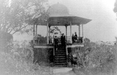
Photograph, John Gray Memorial Rotunda in Surrey gardens, Union Road, Surrey Hills, c 1925, c 1925
The rotunda was built in 1912 by Clarence Montgomery for the Surrey Hills Progress Association and the local community and dedicated to John Gray, "a highly respected and revered citizen". Surrey Hills Brass Band regularly gave concerts in the rotunda, provided music for regular 'loyal' celebrations and also for silent films held in the gardens. The rotunda was quite elevated off the ground due to the slope of the gardens and the bioscope was stored in the room underneath. This was later used as the infant welfare centre until the Progress Association built a dedicated facility for these purposes. The rotunda was demolished in 1972. Clarence Montgomery, carpenter, was living in Sunbury Crescent in 1914. By 1916 he had moved to 83 Croydon Road where he lived for the rest of his life. Clarence was born in 1869 in Taradale, son of John Montgomery and Jane Ford. He married Sarah Ann Ingram in Echuca in 1894. Their children were: 1. Annie (Mrs P Paynter) born Echuca in 1895 2. William Henry born Echuca in 1897 3. Christina Mary (Mrs F Meyers) born Echuca in 1898 4. Violet (Mrs G Ewing) born Echuca in 1902 5. Clarence George Ingram born Echuca in 1906 and died aged 7 months. Violet became a tailoress and Christina a dressmaker. William became a carpenter like his father. Sarah Ann Montgomery died at their home in June 1932 aged 62 years. Clarence died in August 1946 aged 77 years. They are buried in Box Hill Cemetery (P-EB-0020). John Gray was "actively associated with all movements for the benefit of neighbours and fellow citizens". [Quote from the official tribute on his death in 1909.] He was very active in the Surrey Hills Progress Association in the early 1900's. The rotunda built in the Surrey Gardens by the Progress Association in 1912 was dedicated to him. John Gray was born in 1861 in Eldorado. He died on 7 December 1909 in Surrey Hills and is buried in Box Hill Cemetery (M0472). He married Emma Beckett in 1888 at 'Guildford Villa' in Essex Road, the Beckett home. They are listed in both the 1903 and 1906 electoral rolls in Arundel Crescent; his occupation is given as bootmaker. The Alan Holt property register identifies this as 24 Arundel Crescent, known as 'Tumberumba'. John and Emma had a large family: (Gunner) John Robert Gray (1888, Surrey Hills - 21 June 1917, France) Benjamin Walter Gray (1890, Surrey Hills - 1949, Heidelberg) Herbert Harry Gray (1892, Surrey Hills - 1959, Queensland) William Beckett Gray (1897, Surrey Hills - 1899, Surrey Hills) Norman Douglas Gray (1901, Surrey Hills - 1947, Sydney) Evelyn Lizzie Gray (1906, Surrey Hills - 1983) Evelyn married Reginald Roberts and donated a number of photos to the collection. The donor Violet Ewing (nee Montgomery) was Clarence's daughter. She married George Isaac Henry Ewing (blacksmith) in 1934. They inherited the family home at 83 Croydon Road. Although constructed 5 years after their opening, this rotunda was a central feature of the Surrey Gardens which was planted to a design adapted from one suggested by the renowned landscape gardener and botanist William Robert Guilfoyle (1840-1912). Rotundas were a key feature of many late nineteenth and early twentieth century public parks. This particular rotunda was notable for the Chinoiserie influence reflected in its roof. Surrey Gardens are now regarded as one of the City of Boroondara's heritage gardens and this image is significant as evidence of the design of the rotunda which is no longer extant. It is also significant as evidence of the extent of the role of the Surrey Hills Progress Association in the provision of public facilities. A black and white photo of an octagonal rotunda situated within Surrey Gardens taken from the perspective of the main entrance. It is a largely wooden structure with a domed chinoiserie-style roof. The rotunda is enclosed by established gardens. There are 4 people in the photo, with 2 women standing on the steps at the rotunda's entrance. A man and a young person are seated within the rotunda. It has 8 support pillars, which are open with balustrades to 7 sides.rotundas, surrey gardens, union road, surrey hills progress association, surrey hills brass band, parks and reserves, 1925, john gray, clarence montgomery, box hill cemetery, cinema, john gray memorial rotunda, bandstands -
 University of Melbourne, Burnley Campus Archives
Plan, Proposed Sign for Entrance to Burnley, 1931
... . Jessep re design for new entrance gates at Burnley Gardens... design for new entrance gates at Burnley Gardens, between ...(1) Correspondence between Mr Zevan (Government Cool Stores), the Agricultural Superintendent, R. Crowe (Exports Superintendent) and A.W. Jessep re design for new entrance gates at Burnley Gardens, between 31.03.1931 and 09.07.1931. Invoice from signwriter. (2) Pencil sketch of proposed design with anotations. (3) Coloured drawing to scale.On verso of drawing: "Gate sign & Watering plans" and "File State Public Works"mr zevan, cool stores, r. crowe, exports, a.w. jessep, burnley gardens -
 University of Melbourne, Burnley Campus Archives
Plan, Design Concept for Quadrangle Entrance, 1990-2000
... Design Concept for Quadrangle Entrance...Design concept for quadrangle entrance. "Please pass on any... Design concept for quadrangle entrance. "Please pass on any ...Design concept for quadrangle entrance. "Please pass on any comments to Michael Green." (1) View from Quad looking towards main building. (2) Plan.michael green, quadrangle entrance -
 Surrey Hills Historical Society Collection
The Principal Garage at 260 Canterbury Road, Surrey Hills, After 1927
David Staig Jnr established this business in 1927 on the corner of Canterbury Road and Revers Street. He lived at 355 Canterbury Road, one of a series of shops (with living accommodation) owned and built in c1885 by Thomas C Hyde. G Staig (farmer) was the first in the family to occupy this, followed by James Staig (carpenter), then David Staig Snr (blacksmith) and David Staig Jnr. Bill Steiner was the chief mechanic at The Principal Garage; his apprentice Frank Senior eventually bought the business from David Staig and it became Senior's Garage. In 2020 there is a Shell service station and a Coles Express on the site. The Staig family were long-time residents of the area and this photo documents part of their business history. Dave Staig, who established this business, was an early aviator who designed and built his own plane.Black and white photo of a classic 1920's era garage build in brick and render and with 2 petrol bowsers on the curbside, either side of the central garage entrance. Advertising on the facade indicates Shell and Plume motor oils. There are 3 cars positioned in such a way that suggests this may have been a publicity photo. Advertising on the facade indicates that cars could be garaged at the facility and that the proprietor was D. Staig. It also indicates that the business was an agent for The Whippet car, the Willys-Knight car and the Overland car.principal garage, senior's garage, senior's motors pty ltd, garages, redvers street, canterbury road, david staig jnr, bill steiner, frank senior -
 City of Greater Bendigo - Civic Collection
Memorabilia - Invitation and menu card, Joint Installation of Bros. K.J. Fullerton and W. F. Creeth, 1909
Freemasonary or Masonry has its beginnings in local guilds of stonemasons who from the end of 13th century regulated the qualification of stonemasons. Modern Freemasonry uses scriptures which include ritual practices and ethical conduct as part of its foundation and every member must profess a belief in a Supreme Being. Women are not allowed to be admitted and discussion of religion and politics is not to take place within the lodge. Freemasons meet in local Lodges which are supervised at a regional level by a Grand Lodge. The degrees of Freemasonry retain the three grades of medieval craft guilds, those of Entered Apprentice, Journeyman or fellow (now called Fellowcraft), and Master Mason. The candidate of these three degrees is progressively taught the meanings of the symbols of Freemasonry and entrusted with grips, signs, and words to signify to other members that he has been so initiated. The degrees are part allegorical morality play and part lecture. Candidates for Freemasonry will usually have met the most active members of the Lodge they are joining before being elected for initiation. (https://en.wikipedia.org/wiki/Freemasonry) The Golden Lodge of Sandhurst was established as the first Masonic Lodge in Bendigo in 1854. Many prominent men including City Councilors were lodge members at it was a popular way for men to socialise. As the masonic movement expanded further lodges were established in Bendigo and the surrounding Boroughs and Shires. The Golden and Corinthian Lodges purchasing two blocks of land in a prominent position in View Street in 1866 with the intention of erecting a new temple and after amalgamating in 1872 appointed architects Vahland and Getzschmann to design the building. The Bendigo Masonic Hall (now the Capital Theatre) was built in 1873 -74 for both public and private use and contained lodge rooms, a public tavern anda concert hall. The Masonic section occupied the northern side of the building at ground floor level and included a lodge room at the rear, a library and reading room, and other affiliated rooms. Walls of the entry hall and lodge room were decorated with classical columns and panels ornamented with Masonic emblems. The upper level of the building contained a large hall with balcony at the north end and removable stage at the south end. Elaborately decorated with Masonic emblems, this hall was used for Masonic purposes as well as being available to the wider community for social events. The tavern, which became known as the Masonic Hotel, occupied the basement and the ground floor of the southern side of the building and included a sitting room, parlours, billiard room, bedrooms, kitchen, cellars and servants' rooms. It appears that two public entrances were provided for this section, one directly from street level into the basement, the other from the public entry hall. Invitation for the Installation of two Lodge Brothers. Half fold design printed in gold, brown, light blue, dark blue and black ink on white card. Front and back cover decorated with masonic symbols. Menu listed inside. Front cover: Zenith & Golden Corinthian Lodges,/ No. 52 & No. 7./ Joint / Installation / of / Bros. K. J. Fullerton / and W. F Creeth / Masonic Hall / Wednesday, June 30th , 1909 bendigo masonic hall, capital theatre bendigo, milburn catering bendigo, making a nation exhibition, bendigo masonic lodge, city of greater bendigo events, city of greater bendigo community groups -
Friends of Ballarat Botanical Gardens History Group
Work on paper - Botanical Treasures From Far off Places, For the Benefit of the British Empire, 25/9/2008
Further historical information is given here relating to exotic plants discovered by British travellers to the Tropics.This page provides useful background history to the development of wardian cases, significant in the development of Ballarat's gardens during the nineteenth century.One page with a colored photograph of a mangosteen top lefthand of the page followed by one short paragraph and then 3 cabinets designed to hold plants.Nonejohn garner, doctor john garner, ballarat botanical gardens, friends of ballarat botanical gardens, mangosteen, plant cabinets, john ellis, the earl of sandwich., wardian cases, british empire, john garner collection, gardens, ballarat -
Friends of Ballarat Botanical Gardens History Group
Work on paper - Ballarat Botanical Gardens Fernery, Brief for Landscape Design
Ballarat Botanical Gardens Fernery. Brief for Landscape Design.john garner collection, ballarat botanical gardens, fernery, design, landscape, gardens, ballarat