Showing 102 items
matching farm shop
-
 Eltham District Historical Society Inc
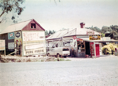
Photograph, Doney's General Store, Research, c.1969
Roadside buildings, formerly Doney's General Store. Doney's operated from the 1880s through to the late 1960s. It was situated at the head of the present day Research shops on Main Road near the corner of Raglan Road. By the 1960s it was under new ownership. The Store had a residence at the back. Signs promote The Herald and Sun newspapers, four 'n twenty pies, coca cola and more. A public phone box is in the front of the store. Beside the store is possibly an old farm building with more signs advertising honey, Streets, Tarax and a local bottle dump. Lyn Dodkins used to work in the Store after school.Digital file onlygeneral store, research (vic.), milkbar, lyn dodkins -
 Whitehorse Historical Society Inc.
Leisure object - Dolls House, Yvonne Fitzmaurice, 1974
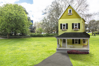
THE DOLL HOUSE _ Yvonne Fitzmaurice The ten room fully furnished American farmhouse was created from an idea by former Mitcham resident, Yvonne Fitzmaurice and was constructed between 1976 and 1978 as a birthday present for her daughter, Susan. The house is a unique interpretation of early American architecture and inferior design. It is also a representation of one woman's ability to create and complete a details snapshot of a lifestyle long gone and give pleasure to family, friends and now the community. Yvonne has had an interesting and full life, born in New Zealand where was a State Registered Nurse and she specialised in hospital theatre work. Later her curiosity bought her to Australia where she worked at the Sydney hospital and with the Australia Flying Doctors service flying in and out of Wilcannia, western New South Wales. On returning to New Zealand Yvonne acted as part of a Medical cover team for the different armed services. one session in the Nary involved pursuing submarines which she described as being very exciting. In 1958 she travelled by sea through the Suez Canal to England and as a member of British Services served in the post WWII Germany for three year in the QARANC and also worked at The London Clinic with some high-profile specialists. Yvonne was introduced to her husband-to-be at a tennis party and they lived in Cambridge, UK, where their two children, Alastair and Susan, were born. On coming to Australia in 1965 as "£10 poms" (Yvonne's words) she worked in casualty at the Box Hill hospital. Initially the family lived at Blackburn South before moving to Mitcham in 1968. To help establish a new life with her family in Australia, Yvonne worked in many different positions from nursing, machine knitting for a Prahran shop, making Christmas Cards and as a commercial traveller. As a hobby she also sold a number of pastel paintings. Following the publishing of her first family history in 1994, Yvonne became a member and volunteer at the Whitehorse Historical Society where she has contributed in producing local history publication, articles for the Newsletter and has improved access to the files by creating the detailed "green files". Her interests include art, crafts and writing. Yvonne has a great philosophy, 'each day I must achieve something - no matter how small'.Hand-made child's doll's house. Built by Mrs Yvonne Fitzmaurice and finished in 1979. This house was built as a 1:12 scale and is a model of a Californian house called Peppercorn farm. House was built by Yvonne and her family and took a period of three years. A lot of the furniture is handmade and the rest is collected from various shops. "Susan Fitzmaurice" name on front of building. Date on plaque on top of front wall.na5059, na5061, na5063, na5065, na5068, na5071, na5073, na5075, na5077, na5079, na5081, na5083 -
 Whitehorse Historical Society Inc.
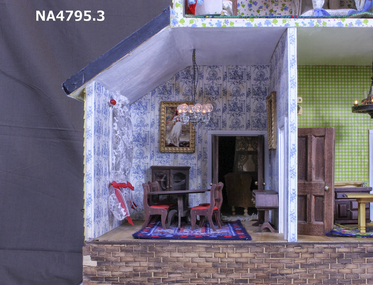
Mixed media - Doll House, Yvonne Fitzmaurice, Doll House Dining Room - contents, 1976-1978
Hand-made child's doll's house. Built by Mrs Yvonne Fitzmaurice and finished in 1979. This house was built as a 1:12 scale and is a model of a Californian house called Peppercorn farm. House was built by Yvonne and her family and took a period of three years. A lot of the furniture is handmade and the rest is collected from various shops. Catalogued books, manuals, repair kits etc used when building the house. house, dolls -
 Whitehorse Historical Society Inc.
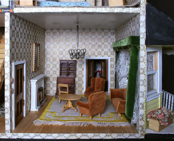
Mixed media - Doll House, Yvonne Fitzmaurice, Doll House Sitting Room - contents, 1976 - 1978
Handmade and imported furniture for doll's house made by Yvonne Fitzmaurice for the daughter, Susan, on her birthday.Hand-made child's doll's house. Built by Mrs Yvonne Fitzmaurice and finished in 1979. This house was built as a 1:12 scale and is a model of a Californian house called Peppercorn farm. House was built by Yvonne and her family and took a period of three years. A lot of the furniture is handmade and the rest is collected from various shops. Catalogued books, manuals, repair kits etc used when building the house.house, dolls, tongue depressors -
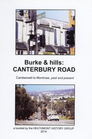 Ringwood and District Historical Society
Book, Burke & Hills: Canterbury Road Camberwell to Montrose, by Heathmont History Group - 2014
Soft cover book of 40 pages with spiral wire spine. Compilation of images and descriptive timeline of the geology, geography and European settlement history of Canterbury Road.Soon after beginning at Burke Road Camberwell, Canterbury Road moves into the gentle hills of Canterbury, then on to Surrey Hills, Box Hill and Forest Hill. Further along past these three "hills" come three "monts" - Vermont, Heathmont and at its other end, Montrose, by then in the foothills of the Dandenongs. Grand homes and churches at one end, major and minor shopping centres along the 25km, factories now where farms were, big box stores, fast food outlets, train stations, resrvoir, traffic, residential stretches, modern apartment blocks, parklands, child-minding centres, sporting ovals, a sewage farm, hotels, quarries, commercial developments, plant nurseries, a golf course, bridges, memorials, Asian food shops, telecommunication towers, bushland, creeks, crossroads, traffic lights, mansions, orchards, swamps ... Delaneys Road, renamed Canterbury Road after a 19th century Victorian Governor, is a fascinating study in land use and history as suburban Melbourne has continually diversified and pushed outwards. Compiled by Heathmont History Group, Rita James, Les Prato, Betty Colbert, Jeff Leipold, Gerry Robinson (convenor). -
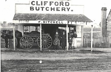 Linton and District Historical Society Inc
Photograph, Clifford Butchery near Linton, F. Mitchell Proprietor
The people in the photograph are not identified, but the man is believed to be Frederick Mitchell, who farmed at Argyle (on road now known as Mitchells Road). The farm was known as Clifford Farm. Frederick Mitchell ran a butcher's shop there from the late 1880s to the mid 1890s. Frederick Mitchell's first wife was Jane McDonagh, and his second wife was Jane's sister Isobel McDonagh.Enlarged black and white copy of original photograph. Photograph shows a shop building with a verandah, which has a shingled roof in fairly poor condition. A sign "CLIFFORD BUTCHERY" is over the shop building, and the name "F. MITCHELL" on the fascia board of the verandah. Three adults and a child are standing outside the shop under the verandah - a man wearing a coat and hat and a long apron, a woman wearing a dark dress and an apron which has a white trim, a young boy, and an older girl who is wearing a dark top and a light-coloured apron. A horse and cart are also under the verandah - horse only partly visible.mitchell family, frederick mitchell, clifford butchery, clifford farm -
 Federation University Historical Collection
Book - Book - Scrapbook, Ballarat School of Mines: Scrapbook of Newspaper Cuttings, Book 64, September 1994 to October 1994
Collection of newspaper articles related to Ballarat School Of Mines.They cover activities and advertisements for staff. The papers concerned are The Courier, Ballarat, The Australian, The Age over the period of 14 September 1994 to 22 October 1994.Book with yellow cover, front, spiral bound. teaching positions advertised, pre-employment courses, courses available, enrolment for smb courses, new secondary training program, uni awards presented, students play the streets, ben chaffey, revision program for vce students, sexual harassment, ann mccaffrey, pirates of the playground, war artist geoffrey mainwarring, joanne crosbie fitter and turner, welcome for vice chancellor, ron wild, john mcclure, pat hope, ballarat city commissioners, jan ince, gwenda mcmanus, gerry anderson, robert hook, dennis else, continuous learning improvement program, clip, challenge day contest, $6m complex for smb, courses help women on farms, smb riders on bay challenge, smb takes on the future, frank kitchen, taishan city, picnic race eating, emma-kate james, michelle loader, fiona carnes, paul armstrong, eureka and its meaning, shop ballarat this christmas -
City of Kingston
Photograph - Colour, Circa 1993
Edithvale is a suburb in the City of Kingston. It is located between Aspendale and Chelsea on the Port Phillip Bay and built within remnant areas of the Carrum Carrum swamp. The foreshore precinct comprises a wide sandy beach, with low sand dunes and numerous historic boat sheds. The suburb consists of older style dwellings and former holiday houses, combined with mid-century housing and newer homes. The large blocks are increasingly subdivided and the existing dwellings demolished to accommodate units and townhouses, thus changing the landscape of the area and reducing the tree canopy.The beachside suburb of Edithvale was previously part of the extensive Carrum Carrum Swamp. The area was once a source of fish and eels for the Mayone-Bulluk clan of the Bunurong people. Over time the area was drained and predominantly devoted to dairy farming and holiday houses. The farms were gradually sold and subdivided with a large number of homes built after World War II and in the 1960s. Edithvale is mainly residential with a shopping strip along Nepean Highway but little significant industry was ever established in the area apart from a plaster works and confectionary factory, both now closed.Aerial colour photograph of Edithvale as viewed from Alexandra Avenue in the north to Ella Grove Chelsea/Edithvale in the south. The area is built-up with residential housing and facilities including Edithvale Primary School, numerous churches and the Edithvale Railway station. Large sections depict the remnant Carrum Carrum swamp. Edithvale Common and the former "Duck Inn" (Melbourne Water/Friends of Edithvale Seaford Wetlands) can be seen. Edithvale Recreational reserve, the velodrome and Edithvale Public Golf Course are prominent. The image shows vacant land in the area now known as Aspendale Gardens and the newer residential section of Chelsea Heights is not developed. A bike path has been established to cover the secondary drain. The Golf Links Court residential development located off Hughes Avenue is a large vacant block.Yellow circular adhesive sticker on plastic Black ink (marker): * (asterisk) Black type on white adhesive sticker: P000108edithvale, aspendale, chelsea, carrum carrum swamp -
Clunes Museum
Painting - PAINTINGS, David Williams
Images of; Horse Trough & Wagon Residence 94 Bailey Street Former Presbytery St. Thomas Aquinas Former Clunes Free Library Residence 25 Camp Street Monument 100 years of gold Clunes in Melb Monument Former butcher's shop Fraser Street Residence & shops 41-43 Fraser Street Clunes School of Mines Clunes War Memorial Residence 32 Leslie St Clunes Former suspension bridge Former St Paul's Vicarage 42 Service Street Former Police Office Former Police residence Portable Lock Up Former Dow Residence 9 Hill St Former Hall & Fire Station 2 Hill St St Paul's timber Church hall St Paul's Church Masonic Lodge 23 Service St St Paul's Pulpit Masonic Lodge interior Everhard cordial bottles Scythes in Clunes Museum Ascot Blacksmith shop Former Ascot hotel MIA Hall Ascot The Coghill Monument Former Methodist Church Coghills Creek Clunes Cemetery Chapel Maiden Hill Homestead shearing shed Beckworth Court stables Beckworth Cour shearer's quarters Former School Evansford Glengower Outbuilding Amerst Former Mortuary 46-50 Fraser Street Wood fired heater Beckworth court farm shed Gold mine trolley Servant's bells Maiden Hill cow bail Former South Clunes school 29 George Street 70 Fraser Street Former Post Office "Allowah" Clunes Street Ascot "Homestead" Beackwith Court "The Meat House" Beckwith Court "Shearing Sheds" Beckwith Court Evansford Community Hall 54 watercolours remaining from the 2003 exhibition held at Clunes, all unframed, depicting Clunes and surrounds architecture and streetscapes.watercolour, 2003 exhibition -
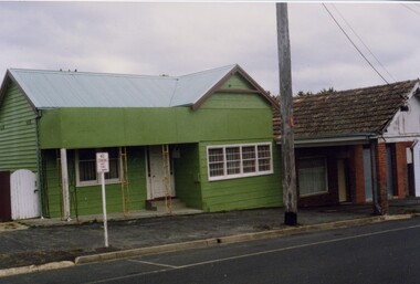 Linton and District Historical Society Inc
Photograph, Buildings, Sussex Street, Linton, 1988
Photograph taken in 1988 of buildings in Sussex Street, Linton: house was previously Bill and Georgie Hall residence and before that a cake shop run by Stella Ralf (Stella Ralf also taught piano). Next to it can be seen the former Bennett garage building. Bennett shop and garage (petrol station) 1920s-1940s. Later (1970s-1981) run as op-shop by Mrs. Surman to raise money for Maxwell Park C.E.B.S. camp. House had a later incarnation as a laundromat in 1980s - at this time many women were still without electricity on outlying farms and house blocks.Colour photograph showing green painted timber house with pitched roof and small verandah, white trim, next to brick building with pitched roof and verandah over footpath, brick pillars. "Stella Ralph's old shop (cake) later Bennett garage"stella ralf, bennett's garage, stella surman, bill hall, georgina hall -
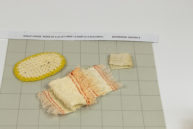 Whitehorse Historical Society Inc.
Mixed media - Doll House, Yvonne Fitzmaurice, Doll House Bathroom - contents, 1974
Hand-made child's doll's house. Built by Mrs Yvonne Fitzmaurice and finished in 1979. This house was built as a 1:12 scale and is a model of a Californian house called Peppercorn farm. House was built by Yvonne and her family and took a period of three years. A lot of the furniture is handmade and the rest is collected from various shops. Catalogued books, manuals, repair kits etc used when building the house.house, dolls -
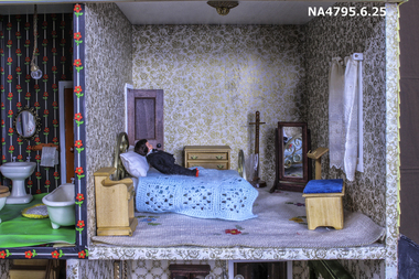 Whitehorse Historical Society Inc.
Mixed media - Doll House, Yvonne Fitzmaurice, Doll House Front Bedroom -contents, 1974
Hand-made child's doll's house. Built by Mrs Yvonne Fitzmaurice and finished in 1979. This house was built as a 1:12 scale and is a model of a Californian house called Peppercorn farm. House was built by Yvonne and her family and took a period of three years. A lot of the furniture is handmade and the rest is collected from various shops. Catalogued books, manuals, repair kits etc used when building the house.house, dolls