Showing 175 items matching "harp road"
-
 Warrnambool RSL Sub Branch
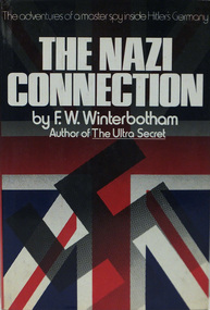
Book, THE NAZI CONNECTION The Adventures of a Master Spy inside Hitler’s Germany
Hard Cover with dust cover Harper & Row Publishers: 1978 Author: F.W. Winterbottom, CBE -
 Warrnambool RSL Sub Branch
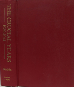
Book, THE CRUCIAL YEARS 1939-1941
... Warrnambool great-ocean-road Hanson W. Baldwin Harper & Row Publishers ...Hard Cover-Red, Title on Spine. Sub-title: The World at War Hanson W. Baldwin Harper & Row Publishers:1976 -
 Ringwood and District Historical Society
Speech, David Harper, Speech given by David Harper (Vice President Ringwood Historical Society) at the launch of the "Heathmont Sketchbook" 29 October 2017, 2017
3 typed pages of the speech given by David Harper at the launch of the 'Heathmont Sketchbook' on 29 October 2017 produced by the Heathmont Research Group -
Ringwood and District Historical Society
Pre-School description, Heathmont Pre-School Murals - explanatory note. 1999, Feb-99
Short explanatory note about the building and murals of Heathmont Pre-School Centre, listing important people involved in the development and opening. +Additional Keywords: Browning, George / Secomb, Frank / Harper, John, OBE,MA,Llm / Angliss, Lady -
Ringwood and District Historical Society
Photograph, Browning, George, Heathmont Pre-School Murals - colour photographs of the exterior murals. 1999, Feb-99
Colour photographs of the exterior murals in the Heathmont Pre-School Centre. Murals were created by George Browning. Three photographs in the set. +Additional Keywords: Browning, George / Secomb, Frank / Harper, John, OBE,MA,Llm / Angliss, Lady / Ritchie, Alan -
 Australian National Surfing Museum
Photograph, Lorne surfers 1920, 1920
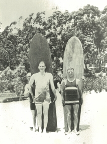
This photograph shows Louis Whyte from Geelong and friends on Lorne Beach in 1920 holding two redwood timber surfboards. In the background can be seen the Lorne foreshore.One of the earliest group photographs of surfers in Victoria. The surfboards and surfers are believed to be the first in Victoria.Black and white photographlorne beach, redwood timber surfboard, ian macgillivray, louis whyte, blue harper -
 Flagstaff Hill Maritime Museum and Village
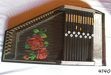
Instrument - Musical, Autoharp, circa 1900
The autoharp is a portable, stringed musical instrument. It is a member of the zither family but differs from the traditional zither in that chords can be easily played. The buttons on the chord bars of the autoharp can be pressed onto the strings to make different sounds. The labels on the autoharp denote the chords and the notes that the strings play. The instrument is played with the box resting on a flat surface such as a tabletop, with the left hand moving the chord buttons and the right hand strumming the strings, usually with a pick or plectrum . The autoharp was invented around the mid-1880s. There are models now available that have variations in the numbers of strings the instrument has, and differences in the sounds of the chords. Typically the autoharp has 36 strings.This autoharp is an example of musical instruments played at social gatherings and concerts in the late 1800s and early to mid 1900s. It was easily carried by the player. It is usually held in the crook of the left arm with the narrow end resting on the should and the left hand supporting the wider end, the hand pressing on the chord buttons. The right hand strums in a similar way to a playing a guitar, usually holding a soft pick or plectrum.Autoharp, painted dark brown with red rose flower decals. The portable stringed musical instrument is a member of the zither family. The autoharp is shaped like a hollow box with one corner cut off. Strings of various lengths are attached with equal spacing, parallel to the long edge of the box. A slotted board rests over the top of the strings at one end, and buttons on the slots can be pressed onto the felt-padded bars below them to produce chords. There are labels on the upper and lower boards that denote chords and musical notes.flagstaff hill, warrnambool, shipwrecked coast, flagstaff hill maritime museum, maritime museum, shipwreck coast, flagstaff hill maritime village, great ocean road, musical instrument, stringed instrument, harp, auto harp, zither, portable -
Glen Eira Historical Society
Article - KOOYONG ROAD, 230, CAULFIELD NORTH, ‘SANQUHAR’
This file contains two items about this property: 1/One page of handwritten research notes, compiled by Claire Barton, about a property located at 230 Kooyong Road, Caulfield North, known as ‘Sanquhar’. Barton acquired the information therein from two sources. The first source – an article from the Argus, dated 13/06/1956, accessed via Trove on 27/08/2013, and titled ‘Old Caulfield Landmark to be Cut Up for Homes’ – notes that the property is to be subdivided into 34 individual lots. The second source – the 1923 and 1942 editions of Sands & McDougall – list the persons dwelling at the property during these years. There exists a discrepancy between these two sources. The article from the Argus implies that the property was not divided until 1956. The 1942 edition of Sands & McDougall, however, implies that it was already subdivided by this date. 2/A printout of the aforementioned article from the Argus itself, again accessed via Trove, this time on 20/06/2014.‘sanquhar’, mansions, kooyong road, glen eira road, caulfield north, barton claire, slatter kate mrs, petterson carl m., petterson e. g. miss, brown jno g., goldsack w. c., robertson j.d., cypress trees, robert harper and co. ltd., robert harper & co. ltd., abercromby & beatty pty. ltd., abercromby and beatty pty. ltd., anderson & hickling, land subdivision, bell family, bell hugh j., padey e.g., jaynes gwen, caulfield city council, anderson and hickling -
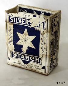 Flagstaff Hill Maritime Museum and Village
Decorative object - Starch, Robert Harper & Co, ca. 1890 to 1940
Starch is used during the laundry process to give fabric a feeling of stiffness. It is used often for linen, shirts and blouses. This box still has the remnants of starch inside it.Starch was used by many households in the late 19th and the 20th century to give linen and uniformsa firm feeling.Box: cardboard rectangular box, blue and white with star graphic. Contents inside. "The Silver Star Starch" Robert Harper and Co Ltd . "The Silver Star Starch" "Robert Harper &O Co."flagstaff hill, warrnambool, flagstaff-hill-maritime-museum, shipwreck-coast, starch, silver star starch, blue star, robert harper and co ltd ., laundry, laundering, washing, bed linen, table linen, decorative linen -
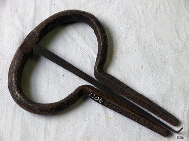 Flagstaff Hill Maritime Museum and Village
Jews Harp
Jew's Harp, metal, with spring steel tuning device placed between two metal arms. Tuning device has hook which you flick to play. Has made in England stamped on arms.flagstaff hill, warrnambool, shipwrecked-coast, flagstaff-hill, flagstaff-hill-maritime-museum, maritime-museum, shipwreck-coast, flagstaff-hill-maritime-village -
Glenelg Shire Council Cultural Collection
Film - Video - Portland Bay Swells, 1983
"Portland Bay Swells", celebrating Portland's sesquicentenary. Devised by Ken Harper and the Portland community. Record of performance at Portland Art Centre.Front: (Reproduction of "Portland Bay Swells" Poster) 1983 - (yellow sticker, l. left). Back: (no inscriptions) -
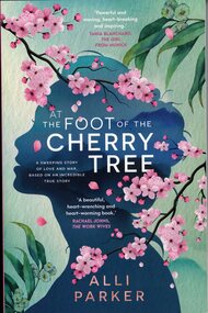 Ringwood and District Historical Society
Book, Allison Parker, At The Foot Of The Cherry Tree by Alli Parker, 2023
Novel based on facts surrounding the author's grandparents, Ringwood residents Gordon and Cherry Parker, focusing on their marriage in post-war Japan and social and beauratic difficulties surrounding their move to Australia as a family, with Cherry as Australia's first Japanese war bride. -
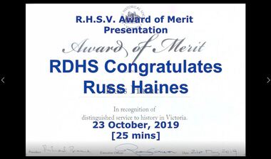 Ringwood and District Historical Society
Mixed media - Video, RDHS Meeting Presentation - Royal Historical Society of Victoria Award of Merit - 2019
Digitised video (1.89GB). Duration: 25 minutes. Recorded October, 2019 (Video is available for viewing at Ringwood & District Historical Society Archives by appointment)In this presentation to Russ Haines in recognition of distinguished service to history in Victoria, David Harper - RDHS Vice President, Don Garden - immediate past President of the Royal Historical Society, Jim Connor - Eltham District Historical Society, and Richard Carter - former RDHS President, speak of Russ’ untiring efforts for RDHS and other history groups during his twelve years as RDHS President. -
Port Melbourne Historical & Preservation Society
Book, Rosalie Thrup Bray, "32 Gellibrand Road 3207, Life and times 1941-71", Jul 2013
Written and published by the author. First edition.Book "32 Gellibrand Road 3207, Life and times 1941-71". Rosalie BRAY (THRUP). Green cover with photo of 32 Gellibrand Road on coverbuilt environment - domestic, garden city, education, war - world war ii, piers and wharves - princes pier, gellibrand road, fishermans bend, millie mclean, roy mclean, sandra sleeth, rene smith, dave mclean, phyllis moore, joe watson, nancy carroll, violet pope, len pope, june moore, lois moore, sis peat, mrs mills, mary edwards, alf edwards, judy faram, swallow & ariell ltd, robert harper & co ltd, j h boyd domestic college, mrs wood mewton, oranje, ss nairana, daisy thrup, rosalie (rosie) bray nee thrup -
Port Melbourne Historical & Preservation Society
Book, Rosalie Thrup Bray, "32 Gellibrand Road 3207, Life and times 1941-71", Jul 2013
Written and published by the author. Second edition printed 2014Book "32 Gellibrand Road 3207, Life and times 1941-71". Rosalie BRAY (THRUP). Green cover with photo of 32 Gellibrand Road on coverbuilt environment - domestic, garden city, education, war - world war ii, piers and wharves - princes pier, rosalie (rosie) bray nee thrupp, gellibrand road, fishermans bend, millie mclean, roy mclean, sandra sleeth, rene smith, dave mclean, phyllis moore, joe watson, nancy carroll, violet pope, len pope, june moore, lois moore, sis peat, mrs mills, mary edwards, alf edwards, judy faram, swallow & ariell ltd, robert harper & co ltd, j h boyd domestic college, mrs wood mewton, oranje, ss nairana, daisy thrup, rosalie (rosie) bray nee thrup -
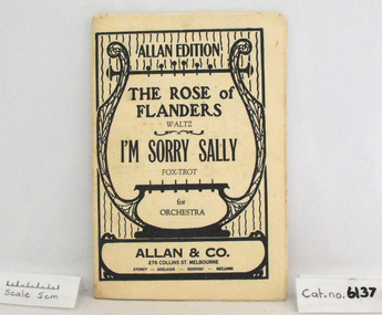 Coal Creek Community Park & Museum
Music Book, The Rose of Flanders (Waltz) / I'm Sorry Sally (Foxtrot)
Music book, white paper with black printed harp that encloses the text. Headed Allan Edition - Song titles: "The Rose of Flanders", Waltz, & "I'm Sorry Sally", Fox-trot, for orchestra. Published by Allan & Co. Melbourne -
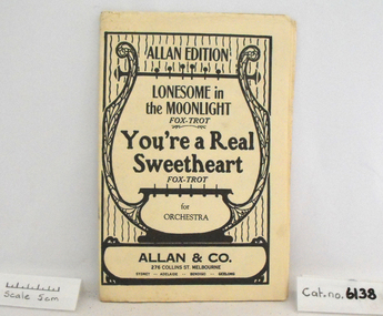 Coal Creek Community Park & Museum
Music Book, You're a Real Sweetheart (Fox-trot) / Lonesome in the Moonlight (Fox-trot)
Music book, white paper with black printed harp design enclosing the text. Headed Allan Edition - Song titles: "Lonesome in the Moonlight" (Fox-trot) & "You're a Real Sweetheart" (Fox-trot), for orchestra. Published by Allan & Co. Melbourne -
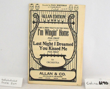 Coal Creek Community Park & Museum
Music Book, I'm Winging Home (Fox-trot) / Last Night I Dreamed You Kissed Me (Fox-trot)
Music book, white cover with black harp design enclosing text. Headed Allan Edition, Song titles: "(Like a Bird that's on the Wing) I'm Wingin' Home" (Fox-trot) & "Last Night I Dreamed You Kissed Me" (Fox-trot), for orchestra. Published by Allan & Co. MelbourneSep. 1928 -
Coal Creek Community Park & Museum
Bottle, essence, Robert Harper & Company Limited
... Coal Creek Community Park & Museum 12 Silkstone Road ...Square glass bottle tapering to neck at top with metal screw top. Label base colour yellow, with red and dark blue text and decoration.Harper's Essence Coffee and chicory 3 fluid ozs. Robert Harper and Company Limited. Manufactured in Victoria, Australia. -
Coal Creek Community Park & Museum
Tin, spice, Robert Harper & Company Limited
Small round tin with lid and paper label.Ground Nutmeg. Robert Harper & Co Ltd. 1 oz net. No.G15031 -
Coal Creek Community Park & Museum
Cooking ingredient, Robert Harper & Company Limited
... Coal Creek Community Park & Museum 12 Silkstone Road ...Cardboard package of spice with paper label.Harpers Whole Spices, 1 oz net, Allspice Pimento. Contains spices -
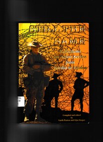 Monbulk RSL Sub Branch
Book, Garth Pratten et al, Still the same: Reflections on active service from Bardia to Baidoa, 1996
War is a noisy, confusing and frightening experience and it is the job of the soldier, usually against better judgement to walk through this storm and secure victory.Index, appendix, ill (b/w) (maps)non-fictionWar is a noisy, confusing and frightening experience and it is the job of the soldier, usually against better judgement to walk through this storm and secure victory. war - psychological aspects, military art and science - australia -
 Monbulk RSL Sub Branch
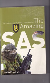
Book, Ian McPhedran, The amazing SAS: The inside story of Australia's special forces, 2005
The Amazing SAS provides a thrilling insight into the way this c0untry's SAS soldiers are selected and trained and reveals fascinating details about recent SAS deployments: East Timor, the 2000 Olympic Games, the Tampa, the Afghanistan campaign and hte regiment's action -packed mission to Iraq.Index, ill (plates, col), p.340.non-fictionThe Amazing SAS provides a thrilling insight into the way this c0untry's SAS soldiers are selected and trained and reveals fascinating details about recent SAS deployments: East Timor, the 2000 Olympic Games, the Tampa, the Afghanistan campaign and hte regiment's action -packed mission to Iraq.australia - army - special air service regiment, australia army - commando forces -
 Monbulk RSL Sub Branch
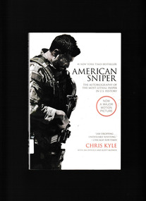
Book, Harper Collins, American Sniper: The Autobiography of the Most Lethal Sniper in U.S. Military History, 2014
The astonishing autobiography of SEAL Chief Chris Kyle, whose record 150 confirmed kills make him the most deadly sniper in U.S. military history.Ill, map, p.379non-fictionThe astonishing autobiography of SEAL Chief Chris Kyle, whose record 150 confirmed kills make him the most deadly sniper in U.S. military history. iraq war 2013, iraq war - personal recollections -
 Monbulk RSL Sub Branch
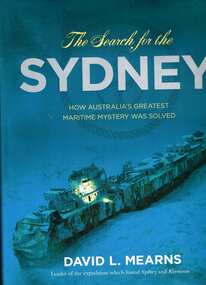
Book, Harper Collins, The search for the Sydney, 2009
Tells the action-packed story of the hunt for the Sydney - and the Kormoran - and reveals what really happened on that fateful day in November 1941.Index, Bibliography, ill, maps, p.264.non-fictionTells the action-packed story of the hunt for the Sydney - and the Kormoran - and reveals what really happened on that fateful day in November 1941.royal australian navy - history, hmas sydney - shipwrecks -
 Dutch Australian Heritage Centre Victoria
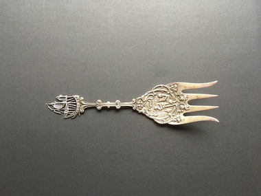
Decorative Fork
Highly decorative silver-coated object in the shape of a four-pronged fork. A sailing ship forms the top of the handle. The handle (or stem) has 2 curlices on each side. The main section depicts a homely interior in which a seated woman plays the harp, a man stands listening and a child sits on the potty. The whole is surrounded by raised vine-like patterning. A very tiny triangle is engraved in the point of the fork at the back. -
Whitehorse Historical Society Inc.
Document, Durk Marcus, /04/2006
Interview with Durk Marcus, who migrated to Australia from Holland in 1951.Interview with Durk Marcus, who migrated to Australia from Holland in 1951. Interviewed by Jan Harper 3 April 2006Interview with Durk Marcus, who migrated to Australia from Holland in 1951. marcus, durk, emigration, oral history migration program, dutch in australia -
Whitehorse Historical Society Inc.
Document - Transcription - Interview, Margaret Skey, 1/03/2006 12:00:00 AM
Interview with Margaret Skey, who migrated to Australia from England in 1957.Interview with Margaret Skey, who migrated to Australia from England in 1957. Interviewed by Jan Harper 28 March 2006. Tape at NP 3463Interview with Margaret Skey, who migrated to Australia from England in 1957. skey, margaret, emigration, oral history migration program, english in australia -
Whitehorse Historical Society Inc.
Article, Rotarian named Citizen of the Year, 25/01/1995 12:00:00 AM
... Whitehorse Historical Society Inc. 2-10 Deep Creek Road ...Article by Janet Blair on Stan Harper, named Nunawading Citizen of the Year for 1994.Article by Janet Blair on Stan Harper, named Nunawading Citizen of the Year for 1994.Article by Janet Blair on Stan Harper, named Nunawading Citizen of the Year for 1994.harper, stan -
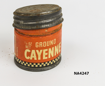 Whitehorse Historical Society Inc.
Container - Spice Tin
Used by donorSmall round spice tin. Orange body of tin with 'ground cayenne' Printed on it.Robert Harper & Co. Ltd. (Incorporated in Victoria) Australiadomestic items, food preparation