Showing 789 items
matching land allotments
-
 Bendigo Historical Society Inc.
Document - H. A. & S. R. WILKINSON COLLECTION: CONTRACT OF SALE
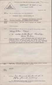
... Contract of sale of land dated 20th January, 1956 between... (purchaser). Property: land being Crown allotment 9 and part of Crown ...Contract of sale of land dated 20th January, 1956 between Sandhurst & Northern District Trustees Executors& Agency (vendor) and Mrs. M. E. Taylor (purchaser). Property: land being Crown allotment 9 and part of Crown allotment 9A section 55C Parish of Sandhurst city of Bendigo, land described in certificate of title volume 4258 folio 516 land coloured red on the plan endorsed hereon, together with brick dwelling known as 199 Bridge Street, Bendigo. Price: 2,650 Pounds.organization, business, h.a. & s.r wilkinson real estate -
 Bendigo Historical Society Inc.
Document - CONNELLY, TATCHELL, DUNLOP COLLECTION: MORTGAGE MRS BRIDGET & MR CORNELIUS DRUM TO THOMAS LUXTON
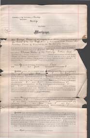
... Luxton, dated 13 Dec. 1892. Land located in Mooroopna, allotment.... 1892. Land located in Mooroopna, allotment 89A, Parish ...Mortgage document, statutory declaration ( Mrs. Drum ) and associated letters from Connelly, Tatchell & Dunlop, Thomas Luxton Stock and Share Broker, Collins St., Melbourne, regarding mortgage between Mrs. Bridget Drum and Cornelius Drum to Mr. Thomas Luxton, dated 13 Dec. 1892. Land located in Mooroopna, allotment 89A, Parish of Mooroopna, County of Rodney.organisation, union, connelly, tatchell & dunlop, thomas luxton, bridget drum, cornelius drum, mooroopna, mortgage -
 Bendigo Historical Society Inc.
Legal record - CLEE William Henry - Contract of Sale, Rogers Collection
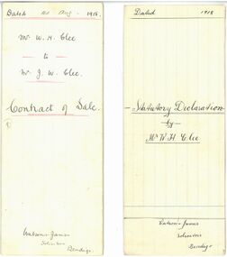
... . Farmer. The piece of land being part of Allotment one hundred... sale of land to his son James William Clee of Piavella Post ...In the early 1980s the firm of Watson, James & Rogers merged with the partnership of Every & Every and became the iconic “Rogers & Every” as known today. The firm is still located on Bull Street. https://rogersevery.com.au/about/ Mr W. H. Clee - Contract of sale and Statutory Declaration. Handwritten documents signed by Mr. William Henry Clee re sale of land to his son James William Clee of Piavella Post Office via Prairie. Farmer. The piece of land being part of Allotment one hundred and fifty-four [unknown symbol] Parish of Wanurp County of Bendigo. Statutory declaration: Shows a small mark in the margin. looks like a capitalized, cursive M. Sales Contract: Hand drawn margins. william henry clee, watson james & rogers, bendigo, legal documents, rogers & every -
 Bendigo Historical Society Inc.
Document - H. A. & S. R. WILKINSON COLLECTION: CONTRACT OF SALE
... land being allotment 326C section H land described in crown... in Havlin street adjoining the above mentioned land being allotment ...Conditions of sale by private contract dated 19th July, 1950 between R. C. Orde (vendor) and H. J. & M. E. Stephenson (purchaser). Property: all that piece of land situate in Havlin Street, Bendigo being part of Crown allotment 326A section H, Parish of Sandhurst City of Bendigo, land described in certificate of title volume 5965 folio 1192804. Also all that piece of land situate in Havlin street adjoining the above mentioned land being allotment 326C section H land described in crown Grant volume 6018 folio 1293456, together with 5 room weatherboard dwelling and all sundry outbuildings, all fly wire doors, window screens, electric light globes and shades, with exception of the shade and chains in the front bedroom. Price: 2,585 pounds.organization, business, h.a. & s.r wilkinson real estate -
 Bendigo Historical Society Inc.
Document - H.A. & S.R. WILKINSON COLLECTION: CONDITION OF SALE
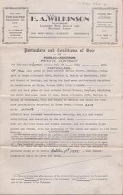
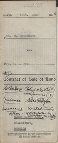
... Contract of sale of land dated 10th June, 1954 between Mrs...) and Mrs A.L. Pye (buyer) for land part of Crown allotment thirteen ...Contract of sale of land dated 10th June, 1954 between Mrs H. Edgecumbe (seller) and Mrs A.L. Pye (buyer) for land part of Crown allotment thirteen AB and twenty section K described in certificate of title volume 5223 folio 518, together with all buildings and erections thereon also all linos, blinds and electric fittings and shades. Price 1900 poundsorganization, business, h.a. & s.r wilkinson real estate -
 Bendigo Historical Society Inc.
Document - H.A. & S.R. WILKINSON COLLECTION: CONDITION OF SALE
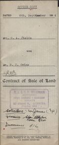
... Contract of sale of land dated 6th September 1954 between...) and Mr. B.T. Owins (buyer) for land being part of allotment 7 ...Contract of sale of land dated 6th September 1954 between Mr G.A. Fields (seller) and Mr. B.T. Owins (buyer) for land being part of allotment 7 section L, Long Gully colored red on the map hereof and being described in Indenture of Conveyance No.422 Book 610 and situate in Inglewood Street Bendigo, together with fencing thereon. Price 130 pounds.organization, business, h.a. & s.r wilkinson real estate -
 Bendigo Historical Society Inc.
Document - H. A. & S. R. WILKINSON COLLECTION: CONTRACT OF SALE
... ). Property: all that piece of land being Crown allotment 275 section... of land being Crown allotment 275 section A, at Long Gully Parish ...Contract of sale of land dated 16th September, 1953 between Miss. S. E. Thomas (vendor) and Mr. A. Truscott (purchaser). Property: all that piece of land being Crown allotment 275 section A, at Long Gully Parish of Sandhurst City of Bendigo being land described in certificate of title volume 236, folio 132 and situate Nos. 4 and 6 Duncan Street, Long Gully, together with 2 weatherboard dwellings and sundry outbuildings, subject to existing weekly tenancy of No. 6 Duncan Street, Long Gully. Price 1,000 pounds.organization, business, h.a. & s.r wilkinson real estate -
 Bendigo Historical Society Inc.
Document - H.A. & S.R. WILKINSON COLLECTION: CONDITION OF SALE
... . Prior (buyer) for land being Crown allotment 5 section 24... of sale of freehold land & dwelling by private contract dated 2nd ...Conditions of sale of freehold land & dwelling by private contract dated 2nd April, 1930, issued by T.C. Watts 7 Son licensed Real Estate Agents between R. Fletcher and T.G. Fletcher executors of the will of R.H Fletcher deceased (sellers) and J. Prior (buyer) for land being Crown allotment 5 section 24 at Eaglehawk having frontage to Campbell Street of 85 links by a depth along Church Street of 223.5 links, land described in certificate of title volume 1541 folio 308073, together with all buildings and erection thereon. Price 415 pounds.organization, business, h.a. & s.r wilkinson real estate -
 Bendigo Historical Society Inc.
Document - H. A. & S. R. WILKINSON COLLECTION: CONTRACT OF SALE
... Contract of sale of land dated 4th December, 1956 between... allotment 466 section H parish of Sandhurst, County of Bendigo, land ...Contract of sale of land dated 4th December, 1956 between Sandhurst & Northern District Trustees as executor in the estate of Catherine Beatty - deceased (seller) and Mr. A. F. & Mrs. A. Thomas (purchaser). Solicitor for purchaser Hogan & Hogan. Property: land being Crown allotment 466 section H parish of Sandhurst, County of Bendigo, land described in certificate of title volume 3047 folio 359 and situate No. 20 Hallam Street, Bendigo together with 5 roomed weatherboard dwelling and all sundry outbuildings, also all linos, blinds, curtains and lamp shades. Price 1,425 pounds.organization, business, h.a. & s.r wilkinson real estate -
 Bendigo Historical Society Inc.
Document - H. A. & S. R. WILKINSON COLLECTION: CONTRACT OF SALE
... : that piece of land being Crown allotment 327 section H Parish... of land dated 15th November, 1956 between Mr. B. A. Bolton and Mr ...Contract of sale of land dated 15th November, 1956 between Mr. B. A. Bolton and Mr. F. B. & Mrs. V. Turner. Property: that piece of land being Crown allotment 327 section H Parish of Sandhurst city of Bendigo, land described in certificate of title volume 3556 folio 136 and situate No. 184 Carpenter Street, Bendigo, together with 6 roomed weatherboard dwelling and all sundry outbuildings, also all floor coverings, inside and outside blinds, curtains, electric light fittings and shades and electric stove. Price: 2,800 pounds. .organization, business, h.a. & s.r wilkinson real estate -
 Bendigo Historical Society Inc.
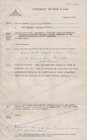
Document - H.A. & S.R. WILKINSON COLLECTION: CONDITION OF SALE
... Contract of sale of land (cash) dated 9th June, 1954... the surface and all that piece of land being part of allotment section ...Contract of sale of land (cash) dated 9th June, 1954 between Mr. R.R. Nancarrow (seller) and Mrs M.R. Potter (buyer) for land above 50 feet below the surface and all that piece of land being part of allotment section K Parish of Sandhurst, City and County of Bendigo described in the plan at the end hereof and thereon coloured red with a frontage to Atkins Street, Bendigo. Price 1,700 pounds.organization, business, h.a. & s.r wilkinson real estate -
 Bendigo Historical Society Inc.
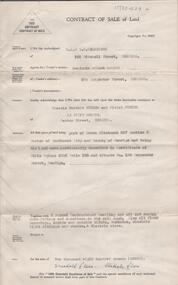
Document - H.A. & S.R. WILKINSON COLLECTION: CONTRACT OF SALE
... of Crown allotment 13 section 97C being the land delineated...) and Mr. J.R. Rose (buyer) for land part of Crown allotment 13 ...Contract of sale of land dated 21st June, 1954 between Mr. T.J. McCarthy (seller) and Mr. J.R. Rose (buyer) for land part of Crown allotment 13 section 97C being the land delineated and coloured red and blue on the map in the margin of certificate of title volume 6325 folio 837 and situate No.450 Hargreaves Street, Bendigo. Together with 7-roomed brick dwelling and all sundry. Price 2.500 poundsorganization, business, h.a. & s.r wilkinson real estate -
 Bendigo Historical Society Inc.
Document - H. A. & S. R. WILKINSON COLLECTION: FARM LEASE
... and Mr. E. W. Traeger. Lease for all that piece of land being.... Lease for all that piece of land being allotment 15B section 7 ...Farm Lease dated 5th July 1957 between Mr. N. E. Watts and Mr. E. W. Traeger. Lease for all that piece of land being allotment 15B section 7 & allotment 15J & 15H of section 7, Parish of Neering in the state of Victoria containing 7 acres 14 perches or thereabouts with dwellings, out-houses and all improvements for the term of 1 year. Terms and conditions: the term of tenancy shall be from the 8th of July 1957 to the 8th July, 1958; the rent for said period shall be 5 pounds fortnightly, the lessee has the option of leasing the property for another 12 months at the same rental; the lessee has the option of purchasing the said property for the sum of 1,350 pounds. Chattels included: 1 draught horse, harness and swings, rubber tyres cart, green feed cutter2,30 dozen egg boxes, 3 ladders, tomato frames and glasses, single furrow plough, set harrows, cultivator, iron spike roller, scuffler, linos, blinds and curtains, ice chest and table. Lessee's copy.organization, business, h.a. & s.r wilkinson real estate -
 Bendigo Historical Society Inc.
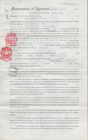
Document - H.A. & S.R. WILKINSON COLLECTION: CONTRACT OF SALE
... (buyer) for land being Crown allotment 2 section 60C having... of land dated 17th April, 1956 between Mr. F.L. & Mrs. M. Hopley ...Contract of sale of land dated 17th April, 1956 between Mr. F.L. & Mrs. M. Hopley (sellers) and Mr. A. & Mrs. V.E. Runting (buyer) for land being Crown allotment 2 section 60C having a frontage of 100 links to Mitchell Street by a depth of 250 links described in certificate of title volume 835 folio 996 and situate No.68 Mitchell Street, Bendigo, together with weatherboard dwelling and all sundry. Also all floor coverings, inside and outside blinds, curtains, electric light fittings and shades. Price 4,750 pounds. Also attached letter from Curnows (Bendigo) to Mr. A. Runting dated 23rd May, 1956 policy of insurance renewal.organization, business, h.a. & s.r wilkinson real estate -
 Bacchus Marsh & District Historical Society
Map, 'Map of Darley' circa 1877-1897
... . Landholders names can be seen on some of the allotments of land marked.... Landholders names can be seen on some of the allotments of land marked ...This map shows the early laid out streets and roads for the village of Darley and the main roads and streets in the central area of the township of Bacchus Marsh. The date of the map is not known. Landmarks indicated on the map including the Anglican Church in Church Street (Gisborne Road), opposite the Presbyterian Church, and the Baptist Church at its pre-1898 Main Street location suggest the map is dated between 1877 and 1897. Landholders names can be seen on some of the allotments of land marked in this map, including the names Clifton, Cosgrove, O'Hagan, McFarlane, Nagle, O'Hagan, Simpson and Vallence.A single page paper map showing the village of Darley and the township of Bacchus Marsh. Scale 10 chains to 1 inch. The map is pasted into a bound volume containing 76 maps or plans in total. High resolution digital image stored on BMDHS computer network. darley victoria maps, bacchus marsh victoria maps -
 Bacchus Marsh & District Historical Society
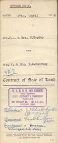
Map, Bacchus Marsh Estate sold 30th June 1888 and sold 28 December 1895
... Single page map showing allotments of land bounded... showing allotments of land bounded by Pilmer Street, Graham Street ...Blocks of land in this area of Bacchus Marsh were sold in lots between 1888 and the late 1890s. This map shows sales made in 1888 and 1895.Single page map showing allotments of land bounded by Pilmer Street, Graham Street, Sydney Street and Maddingley Road (Grant Street) in Bacchus Marsh.The area is dissected by Como Street down the central area. 43 blocks of land are shown with the names of buyers or sellers in 1888 written in black in. Buyers or sellers for December 1895 are written in red ink. Part of a set of maps which are pasted into a bound volume containing 76 maps or plans in total. High resolution digital image stored on BMDHS computer network. bacchus marsh victoria maps, land sales bacchus marsh, pilmer street bacchus marsh, graham street bacchus marsh, sydney street bacchus marsh, como street bacchus marsh, maddingley road bacchus marsh, grant street bacchus marsh -
 Bendigo Historical Society Inc.
Document - H. A. & S. R. WILKINSON COLLECTION: CONTRACT OF SALE
... (purchaser). Property: land being part of allotment 4 section 85C... part of allotment 4 section 85C being land described ...Contract of sale of land dated 7th April 1955 between Mr. G.B. & Mrs. N. M. Seddon (vendor) and Mrs. May Phillips (purchaser). Property: land being part of allotment 4 section 85C being land described in certificates of title volume 2915 olio 817 and volume 2618 folio 510 and situate No. 12 Phillips Street, Bendigo together with weatherboard dwelling and all sundry, also all linos, blinds, curtains, electric light fittings and shades, electric stovette and electric copper. Price: 1,750 pounds.organization, business, h.a. & s.r wilkinson real estate -
![Map, Plan of Town Allotments Bacchus Marsh [1891-1897]](/media/collectors/5e461d8021ea67224c82f2a1/items/66acc1c90c778f9f64a3daec/item-media/66acc3990c778f9f64a3e09b/item-fit-380x285.jpg) Bacchus Marsh & District Historical Society
Bacchus Marsh & District Historical SocietyMap, Plan of Town Allotments Bacchus Marsh [1891-1897]
... A single page paper plan showing allotments of land... Marsh A single page paper plan showing allotments of land ...This plan of town allotments in Lerderderg Street and Bennett Street also includes the location of many of the buildings, shops, businesses and houses which were present in the retail and business area of Bacchus Marsh in the 1890s. The precise date of the plan is not known but it must be sometime between 1891 and 1897. The Post Office and the Wesleyan Church are both shown on this plan. Both of these were constructed in 1890. The plan does not show the Baptist Church in Main Street which was constructed in 1898. Hence the date is sometime between 1891 and 1897.This plan of Bacchus Marsh is one of the most detailed visual representations of the location of shops, businesses and houses in the central part of Bacchus Marsh. It provides very precise locations of most of the shops and houses in the town in the 1890s. A single page paper plan showing allotments of land fronting Lerderderg and Bennett Street. Buildings, businesses and houses along most of the streets are identified by hand written annotations. Streets identified on plan: Lerderderg Street - Bennett Street - Main Street - Gell Street - Young Street - Graham Street. Physical boundaries of the map are: North border - Lerderderg Street - South border - Main Street - West border Gell Street - East border - Young Street. The plan is pasted into a bound volume containing 76 maps or plans in total. bacchus marsh victoria maps, shops bacchus marsh -
 Linton and District Historical Society Inc
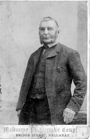
Photograph, Melbourne Photographic Company, Bridge St, Ballarat, Mr W.G Bennett, butcher
... Township, and later purchased farming land and other town... Township, and later purchased farming land and other town ...William Garnsworthy Bennett was at Linton's Diggings in 1856, when he married Susan Williams. Both had migrated from England. W. G. Bennett established a butcher's shop in Linton Township, and later purchased farming land and other town allotments. William and Susan Bennett had twelve children, eight of whom survived to adulthood. W. G. Bennett was a Trustee of the Linton Town Common, was elected to the Grenville Shire Council in 1871,and founded the Linton Rifle Club. After W. G. Bennett's death in 1903, the butcher's shop was run by the Todd family. William and Susan's daughter Elizabeth (Lizzie) married William Todd in 1882.Sepia photograph of a gentleman with long sideboards, moustache and beard, wearing a suit."Mr W G Bennett, Butcher"william garnsworthy bennett, w. g. bennett [butcher] -
 Mt Dandenong & District Historical Society Inc.
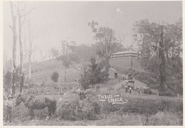
Photograph, The Busy Corner, 1907
... “Jeeves Saddle” in 1907. Isaac Jeeves special strip of land.... Isaac Jeeves special strip of land Crown Allotment “C” 7 chains ...View of Jeeves Saddle in 1907 showing everyday life and including important people and businesses from early settlement - Dodd's grocery and meat cutting carts; Beulah tea Rooms/Post Office; Mrs Hand, Fred Jeeves, Theo Hand.This photograph has a detailed inscription on the back handwritten by John Lundy-Clarke in 1974.“Jeeves Saddle” in 1907. Isaac Jeeves special strip of land Crown Allotment “C” 7 chains wide, lay between the sledge load of pea stalks and the far end of the verandah on Mrs Hand’s “Beulah Tea Rooms” which soon afterwards became the Mt Dandenong North Post Office. The coach road came up from the right behind the tall stump. The big woman in black was Mrs Hand. The wagon at the shop was Dodd’s grocery cart. The nearer wagon was the first coach on the mountain which had belonged to Briarty. The small cart was Dodd’s meat cutting cart. The elm trees are in the centre of the picture and above them is Price’s sign advertising their shop and newsagency. The big house is “Mountjoy” burnt 1975. Walker’s house is among the big trees left centre. Boy at horse’s head is Fred Jeeves. Boy on sledge is Theo Hand. The horse is “Blossom”. Barbers Road goes to the left from behind the elm trees.jeeves, theo hand, fred jeeves, isaac jeeves, barbers road, beulah tea rooms, post office, mount dandenong north, mt dandenong north, kalorama, coach, mountjoy -
 Bendigo Historical Society Inc.
Document - H. A. & S.R. WILKINSON COLLECTION: FARM LEASE
... and Mr. E. W. Traeger. Lease for all that piece of land being.... Lease for all that piece of land being allotment 15B section 7 ...Farm Lease dated 5th July 1957 between Mr. N. E. Watts and Mr. E. W. Traeger. Lease for all that piece of land being allotment 15B section 7 & allotment 15J & 15H of section 7, Parish of Neering in the state of Victoria containing 7 acres 14 perches or thereabouts with dwellings, out-houses and all improvements for the term of 1 year. Terms and conditions: the term of tenancy shall be from the 8th of July 1957 to the 8th July, 1958; the rent for said period shall be 5 pounds fortnightly, the lessee has the option of leasing the property for another 12 months at the same rental; the lessee has the option of purchasing the said property for the sum of 1,350 pounds. Chattels included: 1 draught horse, harness and swings, rubber tyres cart, green feed cutter2,30 dozen egg boxes, 3 ladders, tomato frames and glasses, single furrow plough, set harrows, cultivator, iron spike roller, scuffler, linos, blinds and curtains, ice chest and table. Attached 2 copies of letter from N. E. Watts instructing H.A & S.R. Wilkinson to pay the rent received from Mr. Traeger to Mr. J. R. Watts... Office copy.organization, business, h.a. & s.r wilkinson real estate -
 Bendigo Historical Society Inc.
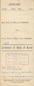
Document - H.A. & S.R. WILKINSON COLLECTION: CONTRACT OF SALE
... . Rundell for land being part of allotment 5 section A, Sailors... of land dated 23rd May, 1956 between Mr. W.T. & Mrs. A. Fuzzard ...Contract of sale of land dated 23rd May, 1956 between Mr. W.T. & Mrs. A. Fuzzard (sellers) and Mr. W.T. & Mrs. J.A. Rundell for land being part of allotment 5 section A, Sailors Gully, having a frontage of 66 feet to Sailors Gully Road, Eaglehawk by a depth of 82 feet 6 inches being land described in deed of conveyance book 463 memorial No.742 and situate No. 64 Sailors Gully Road, Eaglehawk, together with 5-roomed weatherboard dwelling. Also all linos, blinds, electric light fittings and shades and electric copper. Price 2,650 pounds.organization, business, h.a. & s.r wilkinson real estate -
 Bendigo Historical Society Inc.
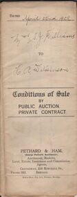
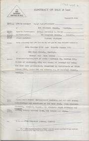
Document - H.A. & S.R. WILKINSON COLLECTION: CONDITION OF SALE
... (seller) and Henry Archibald Wilkinson (buyer) for land part... Archibald Wilkinson (buyer) for land part of Crown allotment 54 ...Conditions of sale by private contract dated 22nd April, 1922 issued by Pethard & Ham between Sarah Jane Williams (seller) and Henry Archibald Wilkinson (buyer) for land part of Crown allotment 54 section M Parish of Sandhurst, city and county of Bendigo described in certificate of title no. 2500 folio 499984. Also part of Crown allotments No. 53 and 54 certificate of title volume 2545 folio 508851, together with 7-roomed brick dwelling. Price 415 pounds Also for documents from Tatchell,Dunlop, Smalley & Palmer Solicitors to Mr. H.A. Wilkinson details the settlement of the Williams estateorganization, business, h.a. & s.r wilkinson real estate -
 Bacchus Marsh & District Historical Society
Map, Lerderderg Park Lands sale plan. 1911
... A single page paper plan showing allotments of land... allotments of land for sale from the Lerderderg Park property owned ...This plan was for the sale of parcels of land from the Lerderderg Park Estate property in 1911. Advertising for the sale appeared in the Bacchus Marsh Express newspaper through July of 1911. The property was situated only a few kilometers from the township of Bacchus Marsh. The agents for the sale were L. A. Fairbairn & Co.Lerderderg Park Estate was a significant and early colonial property in the Bacchus Marsh area. This plan provides details about the first time the property was subdivided for sale. It is therefore documents an important moment in the history of this property and the broader trend of the subdivision of older and larger properties in the district.A single page paper plan showing allotments of land for sale from the Lerderderg Park property owned by John Wills. The parcels of land for sale are coloured in red.The Lerderderg River and Pyke's Creek Irigation Channel shown on the plan are in blue ink. The rest of the plan is a dark cream or beige colur with the text in black ink. The plan has been extensively annotated with hand-written notes indicating the names of people who purchased the various parcels of lands and the prices paid for those lands. Part of the top of the plan containing some text appears to be missing. The plan is pasted into a bound volume containing 76 maps or plans in total. Top: Have received instructions to Sell, account Mr John Wills, his renowned LERDERDERG PARK LANDS, so well and favourably known throughout the Commonwealth. In areas from 3 acres to 1276 acres. Every lot is either rich lucerne land (or portion now under lucerne) with some higher land adjoining Railway Station, and 2 Milk factories within 2 miles, absolutely the finest land in Victoria. Bottom: THIS IS THE FIRST SUBDIVISIONAL SALE of Rich Flats in Bacchus Marsh since the Pyke's Creek Scheme, and every lot is commanded by it. Only 32 miles from Melbourne.bacchus marsh victoria maps, land sales, lerderderg park estate, land subdivision -
 Bendigo Historical Society Inc.
Document - H. A. & S. R. WILKINSON COLLECTION: CONTRACT OF SALE
... (purchaser). Property: land being Crown allotment 362 section... of land dated 3rd April, 1957 between Mrs. J. O. Dean (vendor ...Contract of sale of land dated 3rd April, 1957 between Mrs. J. O. Dean (vendor) and Mr. H. A. & Mrs. F. M. Smith (purchaser). Property: land being Crown allotment 362 section A Parish of Sandhurst city of Bendigo, land described in certificate of title volume 6578 folio 484 and situate No. 134 Inglewood Road, Golden Square, together with all buildings thereon, also all floor coverings, blinds, curtains and electric light fittings and shades and electric stove. Price 2,700 pounds. Attached 2 copies of statement pursuant to section 34 of the estate agents' act 1956, copy of Engagement or appointment in writing pursuant to section 33 of the estate agents' act 1956 and a letter dated 9th April, 1957 signed by solicitors Watson, James, Rogers stating they received from H.A. & S. R. Wilkinson permissive occupancy title No. W54491 in the name of Roy Clifford Dean.organization, business, h.a. & s.r wilkinson real estate -
 The Beechworth Burke Museum
Photograph, 1910
... out plans for new roads and building allotments. Land was sold... out plans for new roads and building allotments. Land was sold ...Taken in 1910, this photograph depicts a scene of Bridge road in Newtown, Beechworth. Walking on the road are two men on horseback, one of which is pulling a carriage with a small dog standing beside it. Behind them are a line of small buildings and shops. Small industries began to expand dramatically in Beechworth, particularly during the 1860s, leading to a strengthening of the towns economy. As early as 1853, areas surrounding the waterway known as Spring Creek were surveyed with the intent of mapping out plans for new roads and building allotments. Land was sold and new buildings were erected, creating an expansion of the Beechworth township and retail services. One building shown in this photograph is Straughair and Duncan's Beechworth Foundry. This business was established in 1858 through the partnership of Mark Straughair and John Duncan. It dealt mostly in the manufacturing of castings and mining machinery, receiving orders from all over the Ovens district. The Business eventually collapsed after the deaths of Straughair in 1882 and Duncan in 1896 but was reopened by W.H. Phillips in 1905. The two other buildings are both associated with the name McKenzie. Evidence suggests that the McKenzie family has a long association with the town of Beechworth. This photograph is historically significant as it provides insight into the nineteenth and twentieth century industrial expansions that happened in the area of Newtown, leading to the urbanisation of Beechworth. Black and white rectangular photograph printed on matte photographic paper mounted on card.Reverse: Newton / 1997.2648 / 33 Newton Beechworth / 84-219-1 / McKenzies / BMM3055 / newtown beechworth, bridge road, 1910, j. duncan, r. mckenzie, m. straughair, industrial growth, ford street, beechworth foundry, straughair and duncan, mckenzie and sons grainstore, mckenzie family store -
 Bendigo Historical Society Inc.
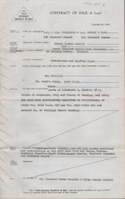
Document - H. A. & S. R. WILKINSON COLLECTION: CONTRACT OF SALE
... of land part of Crown allotment 12 section 19B Parish of Sandhurst... allotment 12 section 19B Parish of Sandhurst City of Bendigo, land ...Contract of sale of land dated 20th May, 1954 between Mrs. B. S. Grant (vendor) and Mr. J. C. & Mrs. V. C. Tarr (purchaser). Solicitors for vendor: Noel & Woodward. Solicitor for purchaser: T. M. Williams, Watson & James. Property: that piece of land part of Crown allotment 12 section 19B Parish of Sandhurst City of Bendigo, land described in certificate of title volume 2734 folio 653 and situate No. 30 Shamrock street, Bendigo, together with 5 roomed weatherboard dwelling and all sundry outbuildings, also electric stovette, electric copper, all electric light fittings and shades, rotary clothes line, all blinds and linos. Price: 2,000 pounds.organization, business, h.a. & s.r wilkinson real estate -
 Bendigo Historical Society Inc.
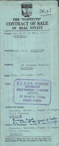
Document - H.A. & S.R. WILKINSON COLLECTION: CONTRACT OF SALE
... allotment 6, section 68c land described in Certificate of title.... Sale of piece of land part of Crown allotment 6, section 68c ...Contract of sale of real estate between Mr. R.T. & Mrs J.V. Mitchell (Vendor) and Mr. R.W. Stretton (purchaser) for property at 28 Olinda Street, Bendigo dated 12th October, 1962. Solicitor for vendor: Messrs Watson, James & Rogers - Bull Street Bendigo. Solicitor for purchaser: Messrs. Watson, James & Rogers of Bull Street, Bendigo. Sale of piece of land part of Crown allotment 6, section 68c land described in Certificate of title volume 4472, folio 399, together with a right of carriageway over the road coloured brown on the map drawn on the said certificate of title, together with all floor coverings, blinds, curtains, electric light fittings and shades, gas fire and gas copper. Price 1,850 pounds.organization, business, h.a. & s.r wilkinson real estate -
 Bendigo Historical Society Inc.
Document - H. A. & S. R. WILKINSON COLLECTION: CONTRACT OF SALE
... (purchaser). Property: piece of land part of Crown allotment 53... of land part of Crown allotment 53 section A at Eaglehawk Parish ...Contract of sale of land dated 26 March, 1956 between Mrs. I.M. Arthur (vendor) and Mr. W. R. & Mrs. V. L. O'Toole (purchaser). Property: piece of land part of Crown allotment 53 section A at Eaglehawk Parish of Nerring County of Bendigo and being land described in certificate of title volume 4870 folio 850 and situate 65 Peg Leg Road, Eaglehawk. Also all the land adjoining being part of Crown allotment 41 section A Parish of Nerring County of Bendigo land described in certificate f title volume 3198 folio 573, together with 6 room weatherboard and brick dwelling and all sundry outbuildings. Also all floor coverings, blinds, curtains and electric light fittings and shades. Price: 1,275 pounds.organization, business, h.a. & s.r wilkinson real estate -
 Kew Historical Society Inc
Plan, Melbourne & Metropolitan Board of Works : Borough of Kew : Detail Plan No.1575, 1905
... allotments of land. Many of these mansions are identified by name... mansions built on large allotments of land. Many of these mansions ...The Melbourne and Metropolitan Board of Works (MMBW) plans were produced from the 1890s to the 1950s. They were crucial to the design and development of Melbourne's sewerage and drainage system. The plans, at a scale of 40 feet to 1 inch (1:480), provide a detailed historical record of Melbourne streetscapes and environmental features. Each plan covers one or two street blocks (roughly six streets), showing details of buildings, including garden layouts and ownership boundaries, and features such as laneways, drains, bridges, parks, municipal boundaries and other prominent landmarks as they existed at the time each plan was produced. (Source: State Library of Victoria)This plan forms part of a large group of MMBW plans and maps that was donated to the Society by the Mr Poulter, City Engineer of the City of Kew in 1989. Within this collection, thirty-five hand-coloured plans, backed with linen, are of statewide significance as they include annotations that provide details of construction materials used in buildings in the first decade of the 20th century as well as additional information about land ownership and usage. The copies in the Public Record Office Victoria and the State Library of Victoria are monochrome versions which do not denote building materials so that the maps in this collection are invaluable and unique tools for researchers and heritage consultants. A number of the plans are not held in the collection of the State Library of Victoria so they have the additional attribute of rarity.Original survey plan, issued by the MMBW to a contractor with responsibility for constructing sewers in the area identified on the plan within the Borough of Kew. The plan was at some stage hand-coloured, possibly by the contractor, but more likely by officers working in the Engineering Department of the Borough and later Town, then City of Kew. The hand-coloured sections of buildings on the plan were used to denote masonry or brick constructions (pink), weatherboard constructions (yellow), and public buildings (grey). Plan No.1575 shows that in the area bounded by Wellington Street, Edgevale Road, Glenferrie Road, and Cotham Road, there had already been significant subdivision of land and houses constructed. As one of the highest points in Kew, as expected, there were already some significant mansions built on large allotments of land. Many of these mansions are identified by name on the plan such as ‘Kelso’, ‘Abbotsford’, ‘Clarendon’ and ‘Ashlyn’ in Cotham Road. Other houses of equal size are unnamed on the plan.melbourne and metropolitan board of works, detail plans, maps - borough of kew, mmbw 1575, cartography