Showing 128 items
matching land settlement in victoria
-
 Lakes Entrance Historical Society
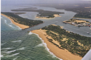
Photograph - Lakes Entrance, Gippsland Ports, 2006 c
Also another copy of same photograph number 03864.1 same sizeColour aerial photograph of the Entrance from Bass Strait into the Gippsland Lakes including Bullock Island, Cunninghame Arm and looking NW across Rigby Island Lakes Entrance Victorialand settlement, waterways, lakes entrance -
 Greensborough Historical Society
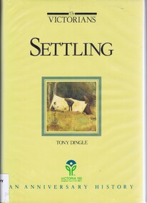
Book, Settling: The Victorians. By Tony Dingle, 1984_
... Aboriginal land use to European settlement. Published to commemorate ...Part 2 of a 3-part series deals with land use from Aboriginal land use to European settlement.Published to commemorate the 150th anniversary of European settlement in Victoria.Hard cover. 274 pages, illus., maps, end maps.victoria land use, victoria history, victoria social conditions, tony dingle -
 Lakes Entrance Historical Society
Book, Leeming, Tarnia, Lake View Hotel, 2003
Research, interpretation and recommendations for management of the Lake View Hotel, Mallacoota, Victoria, by Forestec Student.land settlement, waterways -
 Wodonga & District Historical Society Inc
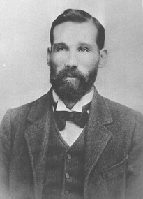
Photograph - Michael "Mick" Mulqueeney Stock Agent, Wodonga
Mick Mulqueeney was born in Kilmore and arrived in Wodonga in 1886, when it was Australia's greatest store cattle market. It was not unusual to see 10,000 cattle sold in a single day. For a few years he spent time overlanding large mobs of cattle from Queensland and the back country of N.S.W He settled in Wodonga and began business as a stock and station agent at Wodonga. He was the Wodonga representative of Edward Trenchard and Co, and other Newmarket stock agents but also conducted auctions on his own account. For several years, he was in partnership with Mr A. L. Wright. Following the retirement of Mr. Wright in 1902, Mick Mulqueeney then joined with Harry H Peck under the trade name of Peck Sons and Mulqueeney. This partnership was dissolved after about 10 years and Mick was bought out by New Zealand Loan. Later he continued in stock and station agency on his own. During this time, he also conducted a very extensive stock forwarding agency where tens of thousands of stock of all classes were shipped owing to the break of gauge from N.S.W, into Victorian trucks and vice versa. He was regarded by stock owners as a genius among stock. Michael also had a sound knowledge of land in the Wodonga district and when the settlement of returned soldiers onto the land was taking place he was appointed valuer of properties being considered by the Repatriation Department. Mick also became a Government stock inspector on the Victorian side of any stock crossing the border. At this time his forwarding agency was carried on by his son, Mr. Jack Mulqueeney. Michael Mulqueeney died on 19th June 1929 and was buried at Yackandandah, VictoriaThis photo is significant because it depicts an important member of the Wodonga community and an vital industry in Wodonga.Two black and white images showing a portrait photo of Michael Mulqueeney and the Mulqueeney family home.michael mulqueeney, stock agents wodonga, livestock sales wodonga -
 Warrnambool and District Historical Society Inc.
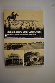
Book, StarPrinting Service Pty ltd, Soldiering On – Caramut and the Soldier Settler Movement, 2018
This book records the history of the post World War Two soldier settlement farms in the Caramut area. Number two in a series of books on Soldier Settlements in Western Victoria.This is a soft cover book of 315 pages. It has a buff-coloured cover with black and white photographs and white printing on the front cover and black printing on the spine. The book includes printed material, black and white photographs, maps and plans. non-fiction This book records the history of the post World War Two soldier settlement farms in the Caramut area. Number two in a series of books on Soldier Settlements in Western Victoria.james affleck, peterborough, soldier settlement, caramut, history of warrnambool, soldier settlement, caramut -
Lakes Entrance Historical Society
Book, Gardner, P D, Names on the Omeo Highway, 1991
Names on the Omeo Highway, Victoria, between Bairnsdale and Omeo; their origins, meanings and historysocial history, historic sites, land settlement -
Lakes Entrance Historical Society
Book, M Holding, Inquests Deaths Worant, Murphy
A folder containg inquests into deaths of two men Roland Worant and Martin Murphy each working on their own properties East Gippsland Victoriasettlers, land settlement -
 Greensborough Historical Society
Book, Making their mark: The Victorians; by Susan Priestley, 1984_
... anniversary of the European settlement of Victoria victoria land use ...This text deals with the economic development of Victoria in the 19th and early 20th century.Published to commemorate the 150th anniversary of the European settlement of VictoriaHard cover. 382 pages, illus., maps.victoria land use, victoria economic conditions, victoria history, victoria social conditions, susan priestley, melbourne suburbs -
Lakes Entrance Historical Society
Book, Stevens Miranda, Tubbut Primary School, 2003
Research, interpretation and management of the Tubbut Primary School building, Tubbut, Victoria by Forestec Studenteducation, land settlement -
Lakes Entrance Historical Society
Book, Walshe, Jemma, The Farm, 2004
Research, interpretation and management recommendations for The Farm, and early mining area at Deptford, near Bairnsdale, East Gippsland, Victoria, by a Forestec student.mines and mining, schools, land settlement -
Lakes Entrance Historical Society
Book, Ernst Jessica, Bullumwaal Cemeteries, 2004
Research interpretation, and management recommendations for the Bullumwaal Cemeteries, north of Bairnsdale, Victoria, by a Forestec Studentcemeteries, mines and mining, land settlement -
Lakes Entrance Historical Society
Book, Rodwell, Daniel J, Battens Landing, 2005
Research, interpretation and management recommendations for Battens Landing site on the Tambo River, East Gippsland, Victoria.The River Tradewaterways, land settlement, mines and mining -
Lakes Entrance Historical Society
Book, Orbost Historical Society Inc, Barns of the Snowy River Orbost, 2006
Documents the distinctive slatted barns of the Lower Snowy River, Orbost, Victoria. Includes sketch maps, barn plans, history of area and families and personal ineterviews.Ngaire Donald May Leatchland settlement, agriculture, natural disasters, transport -
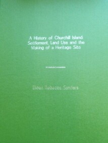 Churchill Island Heritage Precinct
Book - Thesis, Dr E. Rebecca Saunders, A History of Churchill Island: Settlement, Land Use and the Making of a Heritage Site, 2015
An exploration of the intersections between the practices of community engagement, academia and history, the thesis responds to the challenges thrown up by the History Wars and the Churchill Island Project by making a history of settlement that is both academically critical and publicly accepted.A4 format bound text, with green front and back covers and gold writing on front page.non-fictionAn exploration of the intersections between the practices of community engagement, academia and history, the thesis responds to the challenges thrown up by the History Wars and the Churchill Island Project by making a history of settlement that is both academically critical and publicly accepted.saunders, churchill island, settlement, land use, heritage site, thesis 2015 -
 Lakes Entrance Historical Society
Book, Gibson, Tim, Monumental Bairnsdale Cemetery Memories, 1996
A guide to Bairnsdale Cemetery, Victoria, including a plan of the layout, a short history of its development, and genealogical notes of some of the remarkable people buried since commencement.cemeteries, social history, land settlement, memorials -
Lakes Entrance Historical Society
Book, Goding, Alison, This Bold Venture - The Story of Lake Tyers House, 1990
The story of Lake Tyers House, Gippsland, Victoria, built in 1886, and the early tourism industry. It is also describes early transport and land settlement, and touches on Aboriginal life before and after European. Index and bibliography.tourism, aboriginals, transport, waterways -
Lakes Entrance Historical Society
Book, Fish Marie, Carpentertown A History of the New Works Cottages at Lakes Entrance by Marie Fish, 2008
The story of the cottages at the New Works area at Lakes Entrance Victoria, their relationship to the early fishing industry and the construction of the artificial entrance from Bass Strait to the Gippsland Lakes, and the past and recent residents.civil engineering, land settlement -
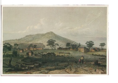 Buninyong & District Historical Society
Artwork, other - Colour reproduction of lithograph "Township of Buninyong" c1852, "Township of Buninyong" c1852
Early image of Buninyong c1852 showing evidence of land clearing, cultivation, residential and farm buildings and Mount Buninyong with tree coverBuninyong was one of the earliest settlements Victoria and became a very important place in the history of the goldrushColour reproduction of lithograph "Township of Buninyong" c1852 from the cover of "Three Times Blest"Henry Winkles Township of Buninyong c 1852 Lithograph, originally published in Montgomery Martin's "Australia" Reproduced "Three Times Blest"early settlement, henry winkles, mount buninyong, buninyong -
Lakes Entrance Historical Society
Book, McMahon, David and Fitzclarence, Eunice, Rob the Milkman - Robert Hamilton McMahon, 2009
An edited account of the diary of Robert Hamilton McMahon written 1917-1918, when he served as 'milkman' for the township of Lakes Entrance and associated settlements, from his dairy herd on Rigby Island and the Barrier, Gippsland Lakes, Victoria.township, land settlement -
Lakes Entrance Historical Society
Book, Skipp, Danny, Milly Aboriginal Massacre Site Broadribb River, 2004
Research, interpretation and management recommendations for the Milly Creek Massacre site, Brodribb River, near Marlo, East Gippsland, Victoria, by a Forestec student.aboriginals, land settlement -
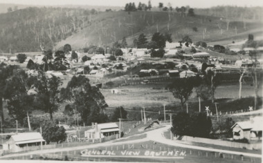 Lakes Entrance Historical Society
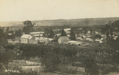
Postcard - Bruthen Victoria, H D Bulmer, 1930 c
Black and white postcard of a general view of town taken from railway station, Bruthen Hotel top right background, railway crossing lower right, Bruthen VictoriaGeneral View Bruthentownship, land settlement -
 Lakes Entrance Historical Society
Postcard - Bruthen Victoria, 1914
Letter on back written by Bruthen rail survey camp worker dated 28/ 6 /14Sepia toned postcard of view of Bruthen showing R C Church on left Congregational Church centre and Church of England just beyond it, Tambo River in the distance Bruthen Victoria. Also a larger black and white copy plus details of letter on the back of original cardBruthen 1914township, transport, land settlement -
 Narre Warren and District Family History Group
Booklet, Narre Warren & District Family History Group Inc, Casey Cardinia Collection - Nar Nar Goon Information File, 2005
Nar Nar Goon, a town in Gippsland, Victoria, has a rich history dating back to the mid-19th century. Originally part of the Kulin nation, the area was home to the Boon Wurrung people. The name "Nar Nar Goon" is believed to come from a Boonwurrung word referring to either the koala or the rakali. European settlement began with the establishment of the Mount Ararat pastoral run in 1844, followed by land sales in the 1850s and 1860s. Many settlers came from Ireland, particularly from the Monteagle estate in Limerick. The arrival of the railway in 1881 was a turning point, facilitating timber and agricultural industries. Several sawmills operated in the area, transporting timber via wooden tramways to the railway station. By the early 20th century, Nar Nar Goon had developed into a thriving township with a general store, hotel, butcher, baker, and garage. The town had strong Catholic roots, with a church opening in 1905. Over time, timber milling declined, and dairy farming became the dominant industry. In 2021, part of Nar Nar Goon was annexed to form the new suburb of Pakenham East. Today, Nar Nar Goon is known for its murals, historical buildings, and community spirit. It remains a small but significant town in Victoria’s history. [AI generated text]Display book containing a table of contents and various newspaper clippings and other information pertaining to the Nar Nar Goon area.non-fictionnar nar goon (vic.), nar nar goon (vic.) -- history, bernie byrne, jack egan, mark & sylvia jones, daisy lia, bill doherty, michael o'brien, joan & frank lindsay, paddy henwood, bob rose, harry james, ray coombs, jack payroll, deb bramley, nar nar goon-maryknoll cricket club, john byrne, bernie dingle, jan van steensel, len & mary bramley, kylie shanks, bill bickerton, james dore, red gem potatoes, brydie cunningham -
 Narre Warren and District Family History Group
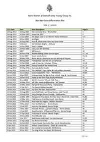
Book, James Bodell, A soldier's view of empire : the reminiscences of James Bodell, 1831-92, 1982
James Bodell was born in 1831 near Nottingham, the son of poor parents. At sixteen he enlisted in the army and was sent first to Ireland, then slowly recovering from the great potato famine, and then to Hong Kong, where most of his regiment died of malaria or other tropical diseases. He bought himself out of the army and went to Van Doiemen's Land (later Tasmania) where he kept a hotel, but eventually became disgusted with the atmosphere of a recent convict settlement. In 1856 he moved to Victoria, where the great gold rush had begun, prospered, but finally lost his money in unwise speculation during a period of excessive drinking. In 1863 he volunteered to serve in New Zealand in the Maori wars. Discharged in 1866, he was given a town lot of land as well as farming land by the government at the town of Tauranga, where he was an outstanding pioneer, making money and becoming Mayor. He later made two return trips to England to visit his family in Leicester. In about 1881 he began to write his reminiscences, an ambitious undertaking for a man with so little formal education, and in 1978, on the death of one of his English descendants, the original manuscript was offered to the Bodley Head for publication. It has been edited by Keith Sinclair and presents a unique picture of how the British Empire was colonised and what life in the British army of the time was like. This is a frank, often amusing and colourful account of the Empire seen from below. (Inside cover)non-fictionJames Bodell was born in 1831 near Nottingham, the son of poor parents. At sixteen he enlisted in the army and was sent first to Ireland, then slowly recovering from the great potato famine, and then to Hong Kong, where most of his regiment died of malaria or other tropical diseases. He bought himself out of the army and went to Van Doiemen's Land (later Tasmania) where he kept a hotel, but eventually became disgusted with the atmosphere of a recent convict settlement. In 1856 he moved to Victoria, where the great gold rush had begun, prospered, but finally lost his money in unwise speculation during a period of excessive drinking. In 1863 he volunteered to serve in New Zealand in the Maori wars. Discharged in 1866, he was given a town lot of land as well as farming land by the government at the town of Tauranga, where he was an outstanding pioneer, making money and becoming Mayor. He later made two return trips to England to visit his family in Leicester. In about 1881 he began to write his reminiscences, an ambitious undertaking for a man with so little formal education, and in 1978, on the death of one of his English descendants, the original manuscript was offered to the Bodley Head for publication. It has been edited by Keith Sinclair and presents a unique picture of how the British Empire was colonised and what life in the British army of the time was like. This is a frank, often amusing and colourful account of the Empire seen from below. (Inside cover)james bodell, maori wars -
 Narre Warren and District Family History Group
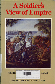
Book, WG Manifold, The wished-for-land : the migration and settlement of the Manifolds of western Victoria, 1984
History of family settlement near Geelong; includes references to incidents involving Jackey Jackey and Gowin Gowin.non-fictionHistory of family settlement near Geelong; includes references to incidents involving Jackey Jackey and Gowin Gowin.manifold family, geelong (vic.) -
 Lakes Entrance Historical Society
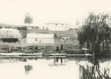
Photograph - Terraced gardens and sign for boats for let on Mitchell River near Bairnsdale Victoria, 1910 c
Sign on river bank 'Boats to Let'Black and white photograph of substancial dwelling terraced gardens and out buildings on riverside, sign indicating boats for hire and five rowing boats on Mitchell River near Bairnsdale Victoriahouses, land settlement, rivers -
 Lakes Entrance Historical Society
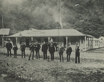
Photograph - Gilberts Hotel Walhalla Victoria, 1910
Black and white photograph showing Gilberts Walhalla Hotel and another building around corner, nine men and a boy standing on road in front, boy on horse in front of building, thick bush in background Walhalla Victoria land settlement, mining, topography -
 Lakes Entrance Historical Society
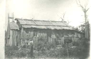
Photograph - Bark hut at Lake Tyers area Victoria, 1900 c
Second identical copy 04618.1Black and white photograph of a bark hut showing walls of vertical sheets of bark held in place by horizontal battons. On the roof overlapping sheets of bark are held in place by a horizontal log attached to the saddle pole on the roof ridge by vertical timbers. Nails were not used wooden pegs or greenhide strips kept the frame stable. This building believed to be in the Lake Tyers area Victoriahouses, land settlement -
 Lakes Entrance Historical Society
Photograph - Old Church House, Tambo Upper, Anne Macarthur, 9/10/2010 12:00:00 AM
The old Church House served the Bruthen community in 1880s when no longer required it was barged to the New Works area where it became Church and meeting hall. By the time the Entrance work was completed the contractor J R Coate had the building moved to Church Street Lakes Entrance. It was a home for various local families until abandoned then acquired by Val Northrope. After renovation by Val in Lakes Entrance it was moved again to a site beside the Northropes new home at Tambo UpperColour photograph of timber cottage surrounded by picket fence four women at gateway. Cottage situated near Bruthen Victoria. Also eight more colour photographs taken of same house showing various aspects of building. houses, land settlement, churches -
 Lakes Entrance Historical Society
Photograph, M Fish, Post and rail fence, Buggy Creek south of Buchan South Victoria, 1/05/1993 12:00:00 AM
Black and white photograph of an old corner post showing mortices to take fence rail at Buggy Creek south of Buchan South Victoria agriculture, farming, land settlement