Showing 229 items
matching loddon
-
 Tarnagulla History Archive
Registration of Birth form, 1872
A large lot of papers, including this and many other birth and death registration forms, were apparently found in the ceiling cavity of the Sandy Creek/Tarnagulla Post and Telegraph Office in the later 20th Century, during building works. Donald Clark Collection. Registration of Birth form for: Child's name: Julia Margaret Frank Date of Birth: 27th March, 1872 Place of birth: Loddon Bet Bet Shire Father: John Frank Mother: Margaret Frank (nee Derby) -
Tarnagulla History Archive
Registration of Birth form, 1871
A large lot of papers, including this and many other birth and death registration forms, were apparently found in the ceiling cavity of the Sandy Creek/Tarnagulla Post and Telegraph Office in the later 20th Century, during building works. Donald Clark Collection. Registration of Birth form for: Child's name: Emma B. Bool Date of Birth: 23rd July, 1871 Place of birth: Loddon B.B. (Bet Bet) Father: Frederick Bool Mother: Elizabeth Ellen Bool (nee Hockey) -
Tarnagulla History Archive
Registration of Birth form, 1872
A large lot of papers, including this and many other birth and death registration forms, were apparently found in the ceiling cavity of the Sandy Creek/Tarnagulla Post and Telegraph Office in the later 20th Century, during building works. Donald Clark Collection. Registration of Birth form for: Child's name: Walter Henry Classon Date of Birth: 8th March, 1872 Place of birth: Newbridge Loddon Father: John August Classon Mother: Elizabeth (Maiden name: section damaged 'Was____') -
Bendigo Historical Society Inc.
Document - MARKS COLLECTION: MAP OF VICTORIA REEF MINING CLAIMS
Copy of map. On bottom LH side of plan Plan of the Victoria Reef Sandhurst January 1867, Compiled by G.W. Hart, Mining Surveyor. Published by John N. Macartney, Argus Agent, Sandhurst. Price 4/- each On bottom Rh side J.W. Pearson & Co. Lith. Melbourne Plan shows mining claims and names of holders, scale ( 4 chains to one inch ) Loddon Road, Mount Korong Road, Ironbark Gully, township of Long Gully, Quartz Miners' Arms and Gold Mines Hotel on Loddon Road.bendigo, mining, victoria reef plan -
Federation University Historical Collection
Book, Historic Sites Survey: North Central Study Area, 1979, 1979
The North Central Study Area included the Shires of Avoca, Bet Bet, east Loddon, Goulburn, Untly, Kara Kara, Korong, Maldon, Marong, Metcalfe, McIvor, Newstead, Strathfieldsaye, Stawell, Talbot, Clunes, Tullaroop and Waranga. 153 page book with white plastic binding. It is an historic sites survey for the North Central Study Area commissioned by the Land Conservation Council, the Ministry for COnservation and the Australian Heritage Commission. castlemaine, mount alexander goldfield, maldon, percydale, warrenmang, moliagul, tarnagulla, stuart mill, the whipstick, whroo, rushworth, graytown ironbark forest, st arnoaud, new bendigo, landsborough, inglewood, kurting, wedderburn, wehla, kooroora, langham flat, mcintyre, rheola, diamond hill, fosterville, coliban water works, green gully, newstead, muckleford forest, costerfield, graytown, bailieston, waranga irrigaiton system, eucalyptus distillery, mia mia bridge, korokubeal township researce, concegella slate quarry, chewton, fryerstown, kingower, timor, talbot, majorca, carisbroook, clunes, st arnaud, taradale, icomos, dunolly, limestone, castlemaine slate quarry, harcourt granite, taradale railway viaduct, loddon united waterworks trust, gouldburn weir, carisbrook lock-up, history of tree planting in streets, history of public reserves, r.u. nicholls nurseryman, thomas lang, francis moss, ballarat botanical gardens, ballarat school of mines botanical gardens, lake wendouree, victoria park, ballarat, muont holled smith, ballaarat old cemetery planting, eastern oval, ballarat east botanical gardens, ballarat east town hall gardens, eureka stockade reserve, ballarat observatory plantings, yarrowee creek plantings, yarrowee bluestone channels, ballarat woollen mill, band and albion mullock heap, black hill plantings, yarrowee creek channels, canadian creek channel, specimen vale channel, poverty point reserve, union jack reserve buninyong, imperial mine, buninyong, victoria street plantings, bridge mall, sturt street gardens, ballarat avenue of honour plantings, white flat oval plantings, camp street, elms, burnt creek -
 Bendigo Historical Society Inc.
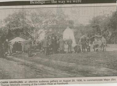
Newspaper - JENNY FOLEY COLLECTION: CAIRN UNVEILING
Bendigo Advertiser ''The way we were'' from Monday, March 12, 2001. Cairn unveiling: an attentive audience gathers on August 29, 1936, to commemorate Major (Sir) Thomas Mitchell's crossing of the Loddon River at Fernihurst. The clip is in a folder.newspaper, bendigo advertiser, the way we were -
 Bendigo Historical Society Inc.
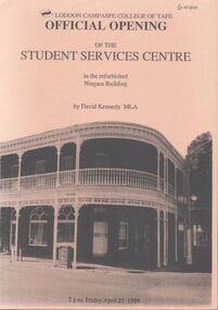
Pamphlet - Loddon Campaspe College of TAFE Program
A5 light brown Bifold pamphlet. Loddon Campaspe College of TAFE Official opening of the Student Services Centre in the refurbished Niagara Building, by David Kennedy MLA Friday April 21 1989 . Includes program and description of Niagara Hotelloddon campaspe college of tafe, niagara hotel, student services centre, david kennedy mla -
 Bendigo Military Museum
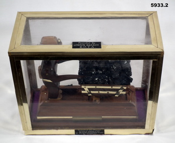
Souvenir - SOUVENIR, COAL TRUCK, Post WW2
Coal was used to run the Water Distillation Plant in Tobruk during the Seige. On plaque, "London Branch", This may actually be "Loddon Branch". Item in the collection re Ron Bollard VX14150, refer cat No 5919P for his service details..1) Base with model depiction of a soldier pushing a coal truck loaded, wood, metal, construction, each side has a brass plaque on the coal truck base, the lower base has a black plaque on..1) Brass plaque, "9th Division 1941", "replica of trucks used to carry coal". .2) On lid, "Donated by LONDON Branch R.O.T.A"sovenir, model, tobruk, coal -
 Bendigo Military Museum
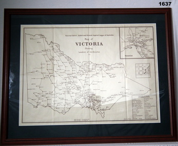
Map - MAP, FRAMED, Bethany Gallery, 1949
This map originally came via Mitiamo East Loddon RSL who when they closed their Sub branch the map and their records were handed to the Bendigo RSL for safe keeping. It was framed and was hanging in the Office of the SMI until the renovations to the building in 2016.Dark green mount with brown wooden frame. Brown printing on cream paper. Perspex covering map.Top centre of map: “Returned Sailors, Soldiers & Airmen's Imperial League of Australia Map of Victoria showing Sub Branches 1949” Stamped on rear: Bethany Gallery. Traditionally a touch of Excellence Terry ? Jarvis, 116 Bridge Street, Bendigo Vic 3550 Ph (03) 5442 4771brsl, smirsl, map rsl's -
 Bendigo Historical Society Inc.
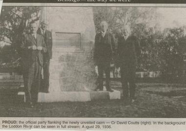
Newspaper - JENNY FOLEY COLLECTION: PROUD
Bendigo Advertiser ''The way we were'' from 2001. Proud: the official party taking the newly unveiled cairn - Cr David Coutts (right). In the background the Loddon River can be seen in full stream; August 29, 1936. The clip is in a folder.newspaper, bendigo advertiser, the way we were -
 Tarnagulla History Archive
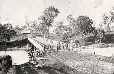
Photograph of the newly completed bridge at Newbridge, Victoria, c.1894, The newly completed bridge at Newbridge, Victoria, c.1894, 1894
Murray Comrie Collection. This photograph is a well-preserved original. Monochrome photograph depicting the newly completed wooden bridge at Newbridge, Victoria. Thirteen men are in the image, standing at one end of the bridge. These are most likely men who worked on constructing the bridge. Position of photographer is on the west bank of the Loddon, looking east.newbridge, bridge, loddon river, infrastructure, construction, roads, workers, farms, people -
 Bendigo Historical Society Inc.
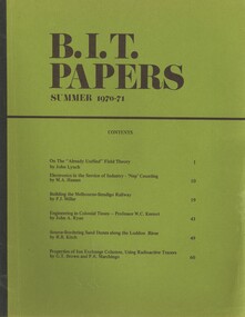
Book - BIT PAPERS, 1971
B.I.T. Papers Summer 1970-71, articles by various contributors, contents include, Building the Melbourne-Bendigo Railway, Engineering in Colonial Times, Source-Bordering Sand Dunes along the Loddon River & others, 66 pages with black and white photographs and maps..history, australian -
Bendigo Historical Society Inc.
Map - DERBY : COUNTY OF BENDIGO, 1959
Map. Derby, County of Bendigo, Bridgewater, Inglewood, Tarnagulla, Woodstock, Leichardt, Loddon River. By authority A.C. Brooks, Government Printer, Melbourne. Drawn and reproduced at the Department of Lands and Survey, Melbourne. 1959. Price 2/-. (number 54 in map cupboard 1)A.C. Brooks, Government Printer, Melbourne.map, bendigo, derby -
 Bendigo Military Museum
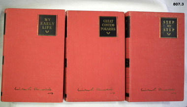
Book - SET OF BOOKS, Odhams Press Limited, 1) My Early Life; .2) Great Contempories; .3) Step by Step, 1) -.3) Reprinted 1948
3. Volume set. Autobiography by Winston Churchill; red cloth covers. Titles in gold on black panels. .1) 373 pages, plain, illustrated, black and white photographs. .2) 309 pages, plain, illustrated, black and white photographs. .3) 350 pages, plain, illustrated, map..1) - .3) Handwritten blue ink on title page "J.M. Coglin Feb 16th, 1949". .2) Handwritten blue ink on title page "Ralph ????ling Strathmore Loddon Vale"books, biography, military history -
Bendigo Historical Society Inc.
Map - DERBY : COUNTY OF BENDIGO, 1-9-09
Map. Derby, County of Bendigo, Inglewood, Loddon River, Tarnagulla, Woodstock, Leichardt, Bridgewater, Bendigo to Inglewood Railway. Photo-Lithographed at the Department of Lands and Survey, Melbourne, by T.E. McGauran 1-9-09. Price 1/-. (number 55 in map cupboard 1)T.E. McGauranmap, bendigo, derby -
Bendigo Historical Society Inc.
Tool - INDIGENOUS STONE TOOL COLLECTION: STONE AXE HEAD, LODDON AREA
Dark brown stone axe head, semi circular in shape. Number 12 stuck on stone. Interpretive sign reads' Stone Age Implements, exhibits 11 - 15. All found on the banks of the Loddon River near Bridgewater, Victoria. Stone Axe Heads'first people, indigenous, loddon river, bridgewater -
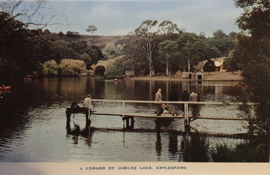 Ballarat Heritage Services
Souvenir - Image from a Postcard Booklet Image, Jubilee Lake, Daylesford, c1945
Daylesford in a tourist town with natural mineral water springs Botanical Gardens, Daylesford Vincent Street, showing Town Hall, Daylesford Vincent Street, Daylesford Glimpse of lovely Jubilee Lake, Daylesford Central Springs, Daylesford Sutton Springs, Daylesford Corner of the beautiful Botanical Gardens, Daylesford Loddon Falls, near Daylesford.daylesford, jubillee lake -
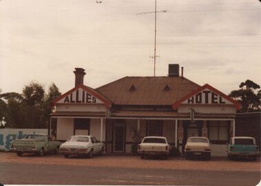 Bendigo Historical Society Inc.
Photograph - BENDIGO HOTEL COLLECTION: ALLIES HOTEL, LODDON VALLEY HIGHWAY
Colour photograph of Allies Hotel, Loddon Valley Highway, Myers Flat, single storey, white painted hotel, gable either end, chimney on LH side, iron roof, plain verandah. Could be early 1970's according to cars parked outside.bendigo, hotel, allies hotel -
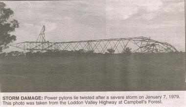 Bendigo Historical Society Inc.
Newspaper - JENNY FOLEY COLLECTION: STORM DAMAGE
BHS CollectionBendigo Advertiser ''The way we were'' from Monday, June 23, 2003. Storm damage: power pylons lie twisted after a severe storm on January 7, 1979. This photo was taken from the Loddon Valley Highway at Campbell's Forest. The clip is in a folder.newspaper, bendigo advertiser, the way we were -
Bendigo Historical Society Inc.
Map - JANIEMBER WEST : COUNTY OF BENDIGO, September 1955
Map. Janiember West, County of Bendigo, Powlett, Janiember East, Jarklan, Kinypanial, River Loddon, Kelsh's Lagoon. By authority W.M. Houston, Government Printer. Drawn and reproduced at the Department of Lands and Survey, Melbourne. Price 2/-.September 1955. (number 64 in map cupboard 1)W.M. Houston, Government Printermap, bendigo, janiember west -
Bendigo Historical Society Inc.
Booklet - Frontier Life in the Loddon Protectorate, 1967
95-page light cover booklet of Episodes from Early Days 1837-1842 in the Loddon Aboriginal Protectorate in Victoria. By Edgar Morrison. Map showing the approximate limits of the Protectorate in Victoria on title page. Map of early station boundaries on page iv. Sketch of an Aborigine holding a spear on front cover. Illustrated with B&W photos. B&W photo of Edward Stone Parker (1802-1865) Protector of Aborigines in the Loddon District. A reprint of Parker's Lecture on the Aborigines of Australia, May 10, 1854, is given in a 31-page section at the back. Foreword by Edgar Morrison Feb. 1967. Hugh McColl, Printer, 'Banner' Office, Latrobe StreetHandwritten in ink on front page. 'To Mr A. Chisholm from Alan J. Hardy (?)aborigines, loddon protectorate, edgar morrison, edward stone parker -
Bendigo Historical Society Inc.
Map - JANIEMBER WEST : COUNTY OF BENDIGO, September 1955
Map. Janiember West, County of Bendigo. Loddon River, Janiember East, Powlett, Kinypanial, Jarklan. Welsh's Lagoon. By authority W.M. Houston, Government Printer, Melbourne. Drawn and reproduced at the Department of Lands and Survey, Melbourne, September 1955, Price 5/-. (number 66 in map cupboard 1)W.M. Houston, Government Printer, Melbourne.map, bendigo, janiember west -
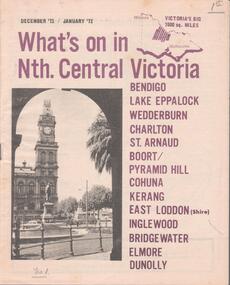 Bendigo Historical Society Inc.
Document - WHAT'S ON IN NTH CENTRAL VICTORIA
Four issues of the ''What's on in Nth. Central Victoria'' advertising booklets. The booklets cover the area of Bendigo, Lake Eppalock, Weddeburn, Charlton, St. Arnaud, Boort, Pyramid Hill, Cohuna, Kerang, East Loddon, Inglewood, Bridgewater, Elmore and Dunolly. Published from December 1971 to May 1972 -
Bendigo Historical Society Inc.
Map - TARNAGULLA : COUNTY OF BENDIGO, 1959
Map. Tarnagulla, County of Bendigo, Sheet 3, Kingower, Glenalbyn, Inglewood, Loddon River, Derby, Gladstone. Drawn and reproduced at the Department of Lands and Survey, Melbourne, 1959. Price 5/- per sheet. By authority A.C. Brooks, Government Printer, Melbourne. (number 35 in map cupboard 1)A.C. Brooks Government Printer, Melbourne.map, bendigo, tarnagulla -
Bendigo Historical Society Inc.
Map - BRIDGEWATER : COUNTY OF BENDIGO, 6-10-27
Map. Bridgewater, County of Bendigo, Inglewood, Salisbury, Derby, Leichardt, Yarraberb, Yarrayne, Bullock Creek, Loddon River, Sandhurst and Inglewood Railway. Photo-Lithographed at the Department of Lands and Survey Melbourne by W.J. Butson, 6-10-27. Price 1/-. (number 53 in map cupboard 1)W.J. Butsonmap, bendigo, bridgewater -
 Victorian Aboriginal Corporation for Languages
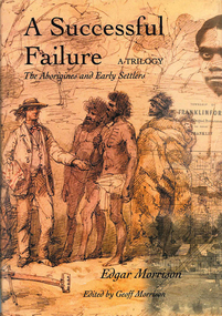
Book, Edgar Morrison, A successful failure, a trilogy : the Aborigines and early settlers, 2002
Tells of the Aboriginal Protectorate System in Colonial Victoria during the period 1838 to 1852. The system was designed to be a buffer between the original inhabitants and the influx of white squatters. That the system failed is of little wonder. This story traces the times of Edward Stone Parker, Assistant Aboriginal Protector in the Loddon region of Victoria.maps, b&w photograph, colour photographs -
 Bendigo Historical Society Inc.
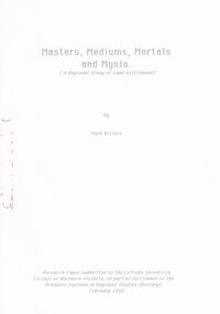
Document - ''THE LODDON LAND SWINDLERS'' CHAPTER FROM RESEARCH PAPER, 1992
''The Loddon Land Swindlers'' - chapter from Research Paper, Graduate Diploma - Regional Studies (History), LaTrobe University College of Northern Victoria (Mark Ritchie, 1992). Research Paper is titled ''Masters, Mediums, Mortals and Mysia - A Regional Study of Land Settlement'' - the first chapter - 21 pages - is titled ''The Loddon Land Swindlers''. Appendix is 'poem' (''The Charge of the Dirty Three Hundred'' (not by Tennyson). Described in the accompanying note to the B.H.S by the author as ''a fascinating event in The History of Bendigo''. It relates to the Amending Land Act of 1865 (known as the 'Grant Act') and to details of the July 1865 involvement of Bendigo people - 200 men - in the Inglewood Land Selections. Reference to 'mediums' and 'dummies'. References to reports of the time in the Bendigo Advertiser.Mark Ritchieinglewood, history, land settlement, amending land act of 1965, james macpherson grant, shamrock hotel, cobb & co, inglewood advertiser, henry byron moore, mr grant minister of lands, dummies, belle-latrobe, inglewood -
 Bendigo Historical Society Inc.
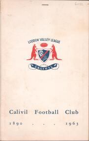
Book - CALIVIL FOOTBALL CLUB 1890-1963, 1964
41 page soft cover booklet 'Calivil Football Club 1890-1963' A history of this football club in the Loddon Valley League with B&W team photos. Edited by H.A .Lister, past player, Captain-Coach, Secretary and Presidemt of the club. Death notice of H.A.Lister stapled inside front cover.H A Lister -
 Ballarat Heritage Services
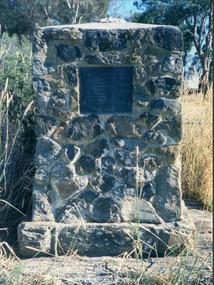
Photograph - Photograph - Colour, Clare Gervasoni, Edward Stone Parker Memorial, Franklinford, 25/10/2015
Franklinford is in the 'shadow' of Mt Franklin, the site of Edward Stone Parker's Aboriginal Protectorate.Photograph of a stone memorial cairn to Edward Stone Parker, Protector of Aborigines. "Edward Stone Parker 1802-1865 Regional Pioneer, Protector of Aborigines Established the Loddon Aboriginal Station Homestead, Church and School near this site in 1841. His devoted service remains a challenge and an Inspiration. April 1965."edward stone parker, protector of aboriginies, aboriginal protectorate, loddon aboriginal protectorate, franklinford aboriginal protectorate, franklinford -
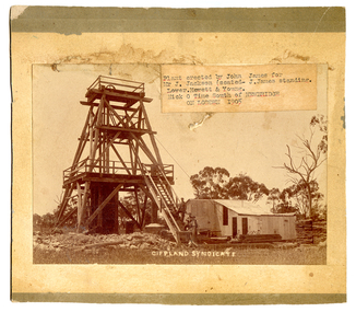 Tarnagulla History Archive
South Gippsland Syndicate mine, Nick o' Time Lead, 1905, 1905
John James is standing on the staircase. He erected the poppet head and buildings on behalf of the syndicate. He was an experienced mine manager and highly regarded local engineer. The mine was located close to and on the western side of the Newbridge-Eddington Road, approximately one kilometer north of the Poseidon Road intersection. The remains of a once-prominent mullock head can be seen on the site. Paper label stuck onto image reads 'Plant erected by John James for Mr J. Jackson (seated - J. James, standing). Lower Hewett & Young. Nick O Time South of Newbridge ON LODDON 1905'.