Showing 108 items
matching navigation chart
-
 Flagstaff Hill Maritime Museum and Village
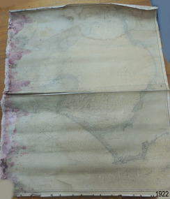
Document - Chart, Admiralty Office, Port Phillip, 1899
Accurate charts were imperative for sea farers to sail their vessels safely from one side of the world to another. The British Admiralty published many charts and updated them frequently. Specialists were employed to gather information such as depth soundings to give the navigator as many helps as possible. At regular intervals the charts had to be updated with the amount of adjustment needed to a compass to allow for magnetic variation.This chart is significant for its association with incoming and outgoin ships for trade and passengers in the late 19th century.Admiralty Chart of Port Phillip, Victoria, South Coast of Australia. It shows navigation buoys, lighthouses, tides and money other details. It was surveyed by Commander Henry L. Cox R.N. in 1864. Published by Admiralty August 19th 1865. Corrections were made by Staff Commander E.J. Stanley R.N. in 1874. The West Channel was surveyed b J.B. Mason , Engineer, in 1899. Published and cartographed in Admiralty, London, England in 1897, supervised by Capt G H Richards R N Hydrographer. Chart was updated in 1899. Sold by W D Potter Agent for Admiralty Charts 145 minorities.Printed: "Port Phillip" "Australia - South Coast, Victoria"flagstaff hill, warrnambool, maritime-museum, flagstaff hill maritime museum & village, shipwreck coast, chart, australia, south coast, port phillip, admiralty, 1899, navigation, cartography, cartographer -
 Flagstaff Hill Maritime Museum and Village
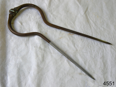
Dividers, Early 20th Century
Dividers are used by navigators to measure the distance between two points on a map or chart. Each point of the divider is places on a map point, then the distance between the points of the divider is measured against the scale of the chart or map. This helps determine the ship's path of travel, the distance travelled and the current location.Not very significant as not associated with any historical event or person, same pattern of dividers is available today from many retail outlets. Also item was probably made around 1940s to 1950sDividers; brass navigator's dividers with fine, stainless steel points. Made in Britain by W & H C (inscription). This navigational tool is used by a ship's navigator to mark the ship's position. Each end point of the divider is placed on a position on a chart or map, then the length between the points of the divider is measured on the chart's scale.Inscribed "British Made" and "W & H C". flagstaff hill, warrnambool, shipwrecked-coast, flagstaff-hill, flagstaff-hill-maritime-museum, maritime-museum, shipwreck-coast, flagstaff-hill-maritime-village, navigational dividers, navigational tool, dividers made by w & hc, w & hc britain -
 Flagstaff Hill Maritime Museum and Village
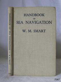
Book - Reference guide, William Marshall Smart (W M Smart), Professor of Astronomy, A Handbook of Sea Navigation, 1943
Author W M Smart, M.A., D.SC., F.R.A.S. (William Marshall Smart), (1889-1975) Regius Professor of Astronomy in the University of Glasgow, Instructor-Lieut. in the Royal Navy during World War I. and John Couch Adams Astronomer in the University of Cambridge. In 1943 he was elected as a fellow of the Royal Society of Edinburg. From 1949-1951 he was President of the Royal Astronomical Society and a member of the Royal Institute of Navigation. In 1958 he was awarded the Lorimer Medal of the Astronomical Society of Edinburgh. The publisher firm, Longmans, Green & Co, was originally founded in 1724 in London by Thomas Longman under the name Longman. In August of that year, he bought the two shops and goods of William Taylor and set up his publishing house there at 39 Paternoster Row. The shops were called Black Swan and Ship, and it is said that the 'ship' sign was the inspiration for Longman's Logo. After many changes of name and management, the firm was incorporated in 1926 as Longmans, Green & Co. Pty Ltd. The firm was acquired by Pearson in 1968 and was known as Pearson Longman or Pearson PLC. The book was sold by Collins Book Depot which was founded by Frederick Henry (Harry) Slamen in 1922. In 1929 the form became a Proprietary Limited Company with an additional two stores, at 95 Elizabeth and 361 Swanston Streets, Melbourne. Collins Booksellers is still owned by the Stamen family. It is the largest Australian-owned bookselling chain.The book is significant due to its connection with navigation at sea. Its author W M Smart was a learned astronomer and an Instructor-Lieutenant for the Royal Navy during World War I. His achievements were recognised in 1958 when he was awarded the Lorimer Medal of the Astronomical Society of Edinburgh.A Handbook of Sea Navigation: The Theory & Practice of Astronomical Navigation at Sea, with diagrams and charts Author: W M Smart, M.A., D.SC., F.R.A.S. (William Marshall Smart) Publisher: Longmans, Green and Co Printer: Collins Book Depot Date: 1943 Textured green hardcover book. Inscriptions on the Fly page.Pencil: "12/6" [12 shillings 6 pence] Sticker: "G.F. Byrne / Faunce Crescent / O'Connor, A.C.T. / Australia 2001" Stamp: "COLLINS BOOK DEPOT PTY. LTD. / Technical Book Department / 361 Swanston St., Melb. G - - -"flagstaff hill, flagstaff hill maritime museum and village, warrnambool, maritime museum, maritime village, great ocean road, shipwreck coast, longmans green and co., thomas longman, paternoster row london, w m smart, william marshall smart, astronomer, navigator, professor of astronomy, 1943, g.f. byrne, collins book depot, technical book department, 361 swanston st., melbourne, frederick henry (harry) slamen, 361 swanston street melbourne, a handbook of sea navigation, maritime handbook, navigation instructiono, sea navigation -
 Port Melbourne Historical & Preservation Society
Map - Chart, Hobson's Bay, river and navigational aids, 1839 - 1843
On back is handwritten note - Hobson's Bay pp from HMS Beagle 1838-43.Map (Chart) of Hobson's Bay, River and Navigational Aids 1839. (Latrobe Library). in photographic form.melbourne harbor trust - port of melbourne authority, hobson's bay -
 Bay Steamers Maritime Museum
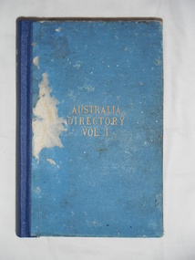
Book, Eyre and Spotiswoode, Australian Directory Volume 1, 1907
... -fiction Australia hydrography charts survey navigation anchorage ...Very significant part of Victorian maritime heritageLight blue cloth hard cover book of 890 pagesInside front cover, handwritten in black calligraphy pen "Hartley F Watson / presented by Capt. Glossop [?] R.N. 1919 / Garden Island, Sydney NSW" Also inside front cover handwritten in blue biro "To MICHAEL WOOD TOPSL SCHOONER 'ALMA DOEPEL' / with COMPLIMENTS HARTLEY F. (BILL) WATSON / c/o R.Y.C.V W'TOWN VIC"non-fiction, australia, hydrography, charts, survey, navigation, anchorage, maps, coast, maritime, marine -
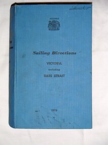 Bay Steamers Maritime Museum
Book, Ports and Harbours Division, Sailing Directions Victoria including Bass Strait, 1970
... fuel maps charts weather navigation Inside front cover, white ...Blue hard cover book of 745 pagesInside front cover, white sticker with red printing "JOHN DONNE & SON / CHARTS, MAPS & MARINE BOOKS / 372 LITTLE BOURKE ST. / MELBOURNE" non-fiction, sailing, victoria, bass strait, communications, fuel, maps, charts, weather, navigation -
 Rutherglen Historical Society
Book, Kath Bentley et al, River of Islands: Charts of the River Murray Yarrawonga Weir to Hume Dam, November 1983
Book contains information and sketch maps to aid in the navigation of the Murray River, with advice on hazards to look for as these will change over time.74 page A4 book with a drawing of a boat on the Murray River on the coverAutographed on the title page by the authors: "9-1-84 Leon Bentley | Kath Bentley"murray river, boating, river navigation, boating safety -
Moorabbin Air Museum
Document - CAC Commonwealth Aircraft Corporation, Air Navigation Regulations including Visual Terminal Chart, Visual Flight Guide and Flight Information Service Communications Chart and Area Forecast Areas
-
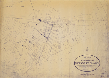 Queenscliffe Maritime Museum
Map - Survey Chart, J. P. Larkin, Re-Survey of Queenscliff Channel, 29 October 1928
A paper chart showing sounding around the Queenscliff Channel dated 1928Victoria Port Phillip October 1928, Re survey of Queenscliff Channelqueenscliff channel, surveying, navigation -
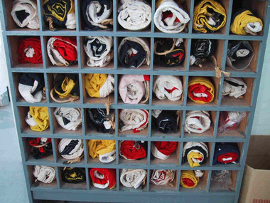 Parks Victoria - Wilsons Promontory Lightstation
Flags, Navigational
The forty-two navigational flags appear to be a complete set. Their purpose-built, grey painted wooden locker is divided into forty-two pigeonholes, each holding one of the rolled up flags. It is simply built and stands on short legs and was originally open-fronted, but has since been covered with a protective clear Perspex panel. The set of alphabetic and numeric visual signalling flags (including substitute and answering pennants) are made of wool in various colour combination designs, with canvas sewn to one end that is threaded with hemp rope. Some of the flags have metal clips attached to the rope. The flags were used for communicating messages to passing ships. Knowledge of visual signalling was mandatory for all lightkeepers and all stations maintained a set of flags. Although used for centuries, visual flag signalling formally developed in the nineteenth century and was published internationally as a system in 1857. By the early twentieth century it had developed into an effective means of conveying all kinds of short range visual messages. Most flags are in good condition and their first level significance is enhanced by their completeness and integrity as a set still housed in their original locker, and by the signal charts that remain in the museum collection which offer further insights into visual signalling.1 - 42. Navigational flag set of 42 individual flags. Coloured linen with canvas sewn to one end which has hemp rope threaded through it. Some flags have metal clips attached to the ends of the hemp rope. 43. Wooden cupboard divided into sections with wooden divides. Used to house the 42 flags. • 1. navy & white. 2. navy & yellow. 3. navy & white. 4. white. 5. red & yellow. 6. yellow & navy. 7. yellow & navy. 8.red. 9.red & white. 10. white & navy. 11. red & navy & white. 12.yellow & navy & & red. 13.navy & white. 14. navy & white. 14. navy & white. 15.navy & white. 16. navy & yellow. 17. yellow & white. 18. white & red. 19. white & red. 20. yellow & red. 21. white & navy. 22. yellow & navy. 23. navy & white. 24. white & navy. 25.red & white. 26. navy & white. 27.red & white. 28.red & white. 29. red & navy. 30. white & navy. 31. yellow. 32.red 7 navy. 33. red. 34 navy,white,red & yellow.35. red & blue. 36. white & red. 37. navy & yellow. 38.red, yellow & white. 39. white. 40. white & red. 41. yellow & red. 42.navy. 43.custom built wooden open cupboard divided into sections to house flags.Yes -
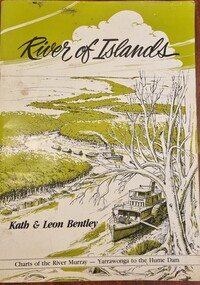 Wodonga & District Historical Society Inc
Book - River of Islands, Kath & Leon Bentley, 1985
A detailed guide to the Murray RIver, including descriptions of the terrain and settlements along the river as well as detailed charts of the river from Yarrawonga to the Hume WeirAn A4 sized publication including text, photos and maps describing the history and surrounds of the Murray River from Yarrawonga to the Hume Weir.A detailed guide to the Murray RIver, including descriptions of the terrain and settlements along the river as well as detailed charts of the river from Yarrawonga to the Hume Weirmurray river navigation, murray river settlement, leisure activities - boating -
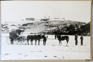 Flagstaff Hill Maritime Museum and Village
Photograph - Scene - Warrnambool, C. 1854-1871
This is an image of the Warrnambool Lighthouse Complex on Middle Island in 1854. The Store, Lighthouse Keeper's Quarters, Lighthouse and Flagstaff are in the background. The foreground shows a covered buggy drawn by two horses and a person in attendance, and another wheeled vehicle behind it with a figure nearby. There is a saddled horse to the right with two males in conversation nearby. The ground is soft, perhaps the riverbed or sandy shore. THE LIGHTHOUSE KEEPERS Lighthouse Keepers were responsible for keeping their Lighthouse’s lights shining at night. They kept a lookout for passing vessels and changes in weather. They were expected to clean, polish and maintain the equipment and buildings. They kept regular and detailed records of who was on watch, and the time the light was lit, trimmed and extinguished. They kept a journal about other events that occurred. They keep regular, accurate Meteorological Logs. It was expected that they were competent in Morse code signalling. They would be called to help in times of disasters and shipwrecks and to give official statements about these events. Many Lighthouse Keepers also volunteered as members of the lifeboat crew. The Lady Bay lighthouses were officially classified as small, so the Keepers had the official titles of Senior Assistant Lighthouse Keeper and Assistant Lighthouse Keeper. They were employed by the Public Service and paid rent to live in the Lighthouse Quarters. They were compulsorily retired at the age of 60, with most receiving a superannuation payment. Despite their time-consuming duties, there was time to follow hobbies and crafts such as growing vegetables, playing musical instruments, making models of buildings including lighthouses, and crafting furniture pieces. An example of a keeper’s skills is the carved fire screen made by /assistant Keeper Thomas Hope in the late 19th century and displayed in the Lighthouse Keeper’s cottage at Flagstaff Hill. Both Alexander and Farncombe had served under Senior Keeper Robert Deverell, who was the first and only Senior Lighthouse Keeper at the Middle Island Complex. John Alexander was the Assistant Keeper in the 1850s. Andrew Farncombe was the last Assistant Keeper at Middle Island, serving there with his family from 1864 to 1871. During 1871 and 1872 the Lighthouse Complex was moved to Flagstaff Hill on Merri Street. Farncombe and Deverell then became the first Keepers and occupants of the Lady Bay Lighthouse Complex at Flagstaff Hill. They continued their service together; overall, Deverell served from 1859 to 1885 and Farncombe from 1864 to 1974. WARRNAMBOOL'S LADY BAY LIGHTHOUSE COMPLEX - The original Lighthouse Complex was built on Middle Island in 1858-1859 then transferred stone-by-stone to Flagstaff Hill in 1871. The Complex comprised the Lighthouse, the Lighthouse Keepers’ Quarters and a Privy. The bluestone Keeper’s Quarters was a cottage divided into two compartments, one for the Senior Keeper and his family, the other for the Assistant Keeper and his family. The bluestone Store was divided into three; a store, a workshop, and an oil store (or office). The Privy comprised a small building also divided into two separate, back-to-back toilets, one for each Keeper and his family. In the 1970s the Flagstaff Hill Planning Board was set up under the chairmanship of John Lindsay. The Board was to make recommendations to the Warrnambool City Council regarding the use of the buildings and the rest of the Crown Land on the site. The Flagstaff Hill Maritime Village opened in 1975 and began renovating the Cottage in stages, during which time evidence of a 1920s fire was found in the eastern section of the cottage. Additions of a porch on the west and a washroom on the east were made in the 1980s. The western part of the building is now a Shipwreck Museum and the east has returned to a late 19th-century Lighthouse Keeper’s cottage and includes the screen made by Assistant Lighthouse Keeper Thomas Hope in the late 19th century. Hope served two periods of time at the Lighthouse. This photograph is significant as a visual record of the original Warrnambool Lighthouse Complex on Middle Island, the origin of what is now the Lady Bay Lighthouse Complex. The photograph is significant for its connection to the Complex, which is now listed on the Victorian Heritage Register, H1520, for being of historical, scientific (technological) and architectural significance to the State of Victoria. The Complex is significant as an example of early colonial development. The photograph is significant for its connection with the important navigational function of the Lighthouses, a function still being performed to this day. The photograph is also significant as it shows an example of buildings organised by the Public Works Department in Victoria in the mid-to-late 19th century. The structures tare still stand strong. Photograph of horses, a buggy and three gentlemen in the foreground and the background shows a lighthouse and accompanying buildings. Printed in black and white. (Another two horse-drawn vehicles are partially visible). The subject is the Lighthouse Complex on Middle Island, Warrnambool, dated between 1854 and 1871.An inscription is handwritten in black pen on the back of the mounting board."The lighthouse and accompanying buildings were / established on Middle Island in 1854, as this / picture shows. In 1871 they were moved to their / present site on Flagstaff Hill."flagstaff hill, flagstaff hill maritime museum, flagstaff hill maritime village, warrnambool, maritime museum, shipwreck coast, lighthouse keeper's cottage, lighthouse residence, lighthouse, chart room, quarters, privy, middle island, beach lighthouse, obelisk, lighthouse complex, lady bay complex, warrnambool port, warrnambool harbour, lady bay, keepers, lighthouse keeper, upper lighthouse, lower lighthouse, assistant keeper, ports and harbours, cottage, meteorological record, 1854, 1871 -
 Port of Echuca
Map - Navigational Chart
... river chart Captains Murray River navigation Map ...river chart, captains, murray river navigation -
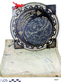 Flagstaff Hill Maritime Museum and Village
Planisphere, Early 20th Century
The word Planisphere (Latin planisphaerium) was originally used in the second century by Claudius Ptolemy to describe the representation of a spherical Earth by a map drawn in the plane. This usage continued into the Renaissance: for example Gerardus Mercator described his 1569 world map as a Planisphere. The word describes the representation of the star-filled celestial sphere on the plane. The first star chart to have the name "Planisphere" was made in 1624 by Jacob Bartsch. Bartsch was the son-in-law of Johannes Kepler, discoverer of Kepler's laws of planetary motion. A significant item of celestial mapping used by marine navigators This particular item was made and used in the first quarter to half of the 20th centuryPlanisphere of northern hemisphere, with canvas bag. Planisphere consists of a circular star chart attached at its centre to an opaque circular overlay that has a clear elliptical window or hole so that only a portion of the sky map will be visible in the window or hole area at any given time. The chart and overlay are mounted so that they are free to rotate about a common pivot point at their centres. The star chart contains the brightest stars, constellations and (possibly) deep-sky objects visible from a particular latitude on Earth. The night sky that one sees from the Earth depends on whether the observer is in the northern or southern hemispheres and the latitude. A Planisphere window is designed for a particular latitude and will be accurate enough for a certain band either side of that. Planisphere makers will usually offer them in a number of versions for different latitudes. Planispheres only show the stars visible from the observer's latitude; stars below the horizon are not included. A complete twenty-four-hour time cycle is marked on the rim of the overlay. A full twelve months of calendar dates are marked on the rim of the starchart. The window is marked to show the direction of the eastern and western horizons. The disc and overlay are adjusted so that the observer's local time of day on the overlay corresponds to that day's date on the star chart disc. The portion of the star chart visible in the window then represents (with a distortion because it is a flat surface representing a spherical volume) the distribution of stars in the sky at that moment for the Planispheres designed location. Users hold the Planisphere above their head with the eastern and western horizons correctly aligned to match the chart to actual star positions. "Made in Germany for GEORGE PHILIP & SONS Ltd. Geographical and Educational Depot, 32 Fleet Street, London" Canvas bag has "Capt. H (Howard) Tyler from Captain H. F. Woolf" "Tyler 22 ? St East Brighton" also "13 Halls St Flinders"flagstaff hill, warrnambool, shipwrecked-coast, flagstaff-hill, flagstaff-hill-maritime-museum, maritime-museum, shipwreck-coast, flagstaff-hill-maritime-village, planisphere, star map, marine navigation, maps, george philip & sons -
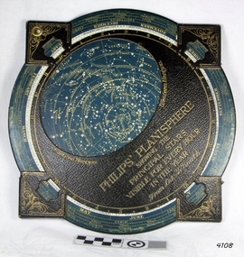 Flagstaff Hill Maritime Museum and Village
Planisphere, Early 20th Century
The word Planisphere (Latin planisphaerium) was originally used in the second century by Claudius Ptolemy to describe the representation of a spherical Earth by a map drawn in the plane. This usage continued into the Renaissance: for example Gerardus Mercator described his 1569 world map as a Planisphere. The word describes the representation of the star-filled celestial sphere on the plane. The first star chart to have the name "Planisphere" was made in 1624 by Jacob Bartsch. Bartsch was the son-in-law of Johannes Kepler, discoverer of Kepler's laws of planetary motionA significant item of celestial mapping used by marine navigators This particular item was made and used in the first quarter to half of the 20th century.Planisphere consists of a circular star chart attached at its centre to an opaque circular overlay that has a clear elliptical window or hole so that only a portion of the sky map will be visible in the window or hole area at any given time. The chart and overlay are mounted so that they are free to rotate about a common pivot point at their centers. The star chart contains the brightest stars, constellations and (possibly) deep-sky objects visible from a particular latitude on Earth. The night sky that one sees from the Earth depends on whether the observer is in the northern or southern hemispheres and the latitude. A Planisphere window is designed for a particular latitude and will be accurate enough for a certain band either side of that. Planisphere makers will usually offer them in a number of versions for different latitudes. Planispheres only show the stars visible from the observer's latitude; stars below the horizon are not included. A complete twenty-four-hour time cycle is marked on the rim of the overlay. A full twelve months of calendar dates are marked on the rim of the star chart. The window is marked to show the direction of the eastern and western horizons. The disc and overlay are adjusted so that the observer's local time of day on the overlay corresponds to that day's date on the star chart disc. The portion of the star chart visible in the window then represents (with a distortion because it is a flat surface representing a spherical volume) the distribution of stars in the sky at that moment for the Planispheres designed location. Users hold the Planisphere above their head with the eastern and western horizons correctly aligned to match the chart to actual star positions. "Sold by J DONNE & SON, Booksellers & Stationers, 349 Post Office Place Melbourne 349. Admiralty Chart Agents" and " Made in Germany for George Philip & Son Ltd" England . Signature "Capt E. B. ?..id, 22 Baund St"flagstaff hill, warrnambool, shipwrecked-coast, flagstaff-hill, flagstaff-hill-maritime-museum, maritime-museum, shipwreck-coast, flagstaff-hill-maritime-village, star map, marine navigation, maps, george philip & sons -
Moorabbin Air Museum
Book - Air Navigation, Air Navigation Royal Air Force
... Air Navigation Mathematics Maps & charts Time Navigational ...Overview of principles, mathematics, theories of air navigation circa 1944Overview of principles, mathematics, theories of air navigation circa 1944mathematics, maps & charts, time, navigational theory -
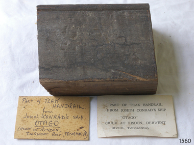 Flagstaff Hill Maritime Museum and Village
Souvenir - Wood Sample, Alexander Stephen and Sons, 1869
... , and a navigation chart of Otago Harbour. The sample of teak is significant ...This teak wood sample was part of a handrail from the wreck of the ship Otago. The Otago 1869-1931 The iron-hulled 3-masted barque Otago was built in Glasgow by Alexander Stephen & Sons Ltd, Kelvinhaugh, as a merchant ship and launched in 1869. The vessel changed hands several times in the late 19th century after being sold to an Australian firm in 1871. During one of its voyages, the captain died while the ship was in port at Bangkok. Marine author Joseph Conrad was on board and, being a qualified captain, he took command and continued the journey to Sydney and Mauritius. It was the only ship he ever commanded. In 1903 the Melbourne shipping company Huddart, Parko & Co., purchased the Otago and converted it to serve as a coal hulk for use in Sydney. The Otago was later sent to Hobart, Tasmania, where it continued as a hulk until 1931. It was sold for scrap and eventually abandoned on the banks of the Derwent River at a place now known as Otago Bay, opposite Conrad Drive, Otago. The outline of the hull is still visible and a nearby plaque tells the story. There are other vessels also named Otago, one of them in the same year. Joseph Conrad (1857-1927): - Polish-born Joseph Conrad became a British subject in 1886. He was a renowned marine fiction writer and, for a short time, a mariner and Captain. As a 13-year-old boy, Joseph Conrad desired to be a sailor. At 19, he joined the British merchant marine, working in several roles. He eventually qualified as a captain but only served in this role once: from 1888 to 1889, when he commanded the barque Otago, taking over from the deceased captain and completing the ship’s journey from Sydney to Mauritius. In 1889 he began writing his first novel, Almayer’s Folly. He retired from life as a mariner in 1894, aged 36. Conrad’s affection for Australia and his visits to Australia from 1878 to 1982 were later commemorated by a plaque in Circular Quay, Sydney. Conrad continued as an author; some characters in his books were said to be inspired by his maritime experiences and the people he had met. By the end of his life, he had completed 19 novels, many stories, and essays, plus one incomplete novel, Suspense, which was finished and published posthumously. In 1924, Prime Minister Ramsay MacDonald offered Conrad a knighthood for his work but he declined. There is an 1882 sailing ship named the Joseph Conrad, after the author, that is now preserved at the Mystic Seaport Maritime Museum in the USA as part of the fleet of historic ships, used as an exhibit and a training ship. The Danish square-rigged training ship was originally named Georg Stage but was renamed by marine author Alan Villiers when he bought It in 1934. The wood sample from the Otago is significant for its association with renowned marine author Joseph Conrad, who had once commanded the vessel; it was his only command as Captain and was known as Joseph Conrad's Otago. The maritime connection with Conrad extends to items in the collection, including some of his maritime novels based on his first-hand knowledge, a wooden ship model of a ship named after him, and a navigation chart of Otago Harbour. The sample of teak is significant as an example of materials used in the construction of the 1869 iron-hulled sailing ship, built in Glasgow, Scotland, specifically for use to sail across the world with cargo to trade between the colonies including Australian ports. Wood sample; a rectangular section of a teak wood handrail that has a bead planed along one side. Two cards with the sample have inscriptions, one handwritten and one typed. The sample is from the wreck of the barque Otago, once under the command of Captain Joseph Conrad. Handwritten card: "PART OF TEAK HANDRAIL / from / Joseph CONRAD'S ship / OTAGO / (HULK at RISDON, DERWENT River, TASMANIA) Typed card: "PART OF THE TEAK HANDRAIL / FROM JOSEPH CONRAD'S SHIP / "OTAGO" / (HILK AT RISDON, DERWENT / RIVER, TASMANIA)"flagstaff hill, flagstaff hill maritime museum and village, warrnambool, maritime museum, maritime village, great ocean road, shipwreck coast, joseph conrad, joseph conrad's ship, captain joseph conrad, otago, barque otago, merchant ship, cargo ship, hulk, 1869 ship, iron hull, sailing ship, handrail, fitting, souvenir, wood sample, teak, new zealand, sydney, newcastle, tasmania, hobart, derwent river, otago harbour, otago bay, conrad drive, 19th century, mauritius, marine author, marine novel, alex villiers, georg stage -
 Flagstaff Hill Maritime Museum and Village
Photograph - Historical, building, Late 19th to early 20th century
The black and white photograph depicts the Lady Bay Lighthouse Complex at Flagstaff Hill, Warrnambool. It was opened on this site in 1871. From left to right, the Chartroom (previously named the Store), Upper Lighthouse, Flagstaff, Lighthouse Keeper's Quarters. The bluestone buildings are facing North on Merri Street. The Harbour Pilot's Lodgings were on the east of the Complex. There are two unknown male figures standing in front of the light-coloured picket fence that encompasses the Complex. The photograph is mounted on card. WARRNAMBOOL'S LADY BAY LIGHTHOUSES In the 1800s ships sailing from England to Australia began to use Bass Strait as a faster route to Melbourne. Small navigation errors led to many tragic shipwrecks. From 1848 lighthouses were operating along Victoria’s southern coast as a guide for sailors. Coastal towns such as Warrnambool grew and the exchange of trade and passengers was of great benefit. However, the uncertain weather changes, relatively shallow waters and treacherous, hidden rocky reefs were not really suitable for a Harbour and in the 1840s and 1850s, there were many shipwrecks in the area, with some even stranded in its Lady Bay harbour. A jetty was built in 1850 and a flagstaff to guide seafarers was placed up high on what became known now as Flagstaff Hill. In November 1857 the Victorian Government recommended that Warrnambool Harbour had beacons and two lighthouses to guide vessels into and out of the Harbour safely. The white light of the Middle Island lighthouse was to be used for the first time on September 1, 1859. The red light of the Beach Lighthouse, a wooden obelisk structure, was first operated on March 25, 1860, but in 1868 this light was ‘discontinued’ due to it being too low. Melbourne’s Department of Public Works decided to relocate the Middle Island Lighthouse Complex - Lighthouse, Keeper’s Quarters, Privy, Store Room and even water tanks - to Flagstaff Hill. The lower obelisk was shortened, and a protruding gallery, railing, and external ladder were added, and the light from the Beach Lighthouse. A green guiding light was erected on the end of the jetty. The transfer of the Complex began in March 1871. Each shaped stone of the lighthouse was carefully numbered, removed then reassembled on Flagstaff Hill. In 1872 the well was sunk behind the Lighthouse Keeper’s Cottage. The Keepers and families had left Middle Island in April and moved to Flagstaff Hill in October 1871. Vessels entering Lady Bay align the Upper and Lower Lighthouse towers during the day and the lights at night. The Upper Lighthouse is a round tower, and the Lower Light is square. The Lighthouses were categorised as harbour lights rather than coastal lights, so they remain under the control of the Victorian Government’s Ports and Harbours section. The lights were originally powered by oil, then acetylene gas, later by electricity, and then converted to solar power in 1988. In 1993 the solar panel was replaced by a battery charger. A decision was made in 1936 to replace the lighthouses’ lights with unattended lights that no longer required Keepers and Assistants. At least 29 Keepers had attended to the lighthouse from its opening in 1859 to when the last official Lightkeepers left In April 1916. The Warrnambool Harbour Board rented out the Quarters from 1916 to 1936. The Board closed down but the rentals continued with other unknown landlords. In the 1970s the Flagstaff Hill Planning Board was set up under the chairmanship of John Lindsay. The Board was to make recommendations to the Warrnambool City Council regarding using the buildings and the rest of the Crown Land on the site. The Flagstaff Hill Maritime Village opened in 1975 and began renovating the Cottage in stages, during which time evidence of a 1920s fire was found in the eastern section of the cottage. Additions of a porch on the west and a washroom on the east were made in the 1980s. The western part of the building is now a Shipwreck Museum and the east has returned to a late 19th-century Lighthouse Keeper’s cottage and includes the screen made by Assistant Lighthouse Keeper Thomas Hope in the late 19th century. He served as Assistant Keeper in Warrnambool for two periods.The Warrnambool Lighthouse Complex is now listed on the Victorian Heritage Register, H1520, for being of historical, scientific (technological) and architectural significance to the State of Victoria. The Complex is significant as an example of early colonial development. The buildings are significant for their connection with the important navigational function of the Lighthouses, a function still being performed to this day. The buildings are also significant as an example of structures designed and works carried out by the Public Works Department in Victoria in the mid-to-late 19th century. The structures still stand strong. Photograph; Warrnambool Lighthouse Keeper's cottage, lighthouse, flagstaff and chartroom at Flagstaff Hill, and a light-coloured picket fence with gate. Two male figures are in front of the fence. Black and white print glued to a yellow card. The inscription is indecipherable. The right side of the cottage has a built-in, enclosed addition.Ink stamped in lower right hand corner, too faded to be legible.flagstaff hill, flagstaff hill maritime museum, flagstaff hill maritime village, warrnambool, maritime museum, shipwreck coast, lighthouse keeper's cottage, lighthouse residence, lighthouse, chart room, quarters, privy, middle island, beach lighthouse, obelisk, lighthouse complex, lady bay complex, warrnambool port, warrnambool harbour, lady bay, keepers, lighthouse keeper, upper lighthouse, lower lighthouse, assistant keeper, ports and harbours, cottage