Showing 330 items matching "nepean road"
-
 City of Kingston
Photograph - Black and white, c. 1950
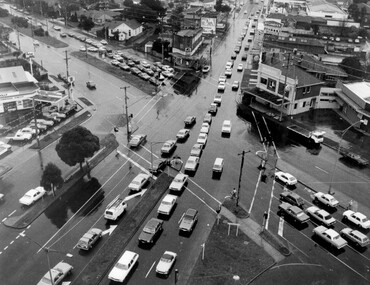
... of the intersection of Nepean Highway and South Road, taken from above... of the intersection of Nepean Highway and South Road, taken from above ...The image shows a line of traffic travelling along South Road in response to traffic light signlas while an increasing number of cars are banking up along Nepean Highway, also in response to traffic light signals.This image provides a strong contrast to images from earlier eras of the same intersection. The amount of traffic has increased enormously as well as commercial development.Black and white photograph with an aerial view of the intersection of Nepean Highway and South Road, taken from above the Moorabbin Council Chambers.Handwritten in black ink Pic [indecipherable] / 1000 Handwritten in red ink: 150%moorabbin, traffic lights, cars, nepean highway -
 City of Moorabbin Historical Society (Operating the Box Cottage Museum)
Pamphlet - St Finbar's Parish Church, East Brighton - Celebrating 150 Years 1848-1998, 1998
... St Finbar's Roman Catholic Church corner of Nepean Highway... Cottage Museum) Joyce Park Jasper Road Ormond melbourne St ...St Finbar's Roman Catholic Church corner of Nepean Highway and Centre Road, East Brighton.St Finbar's Roman Catholic Church East Brighton was erected in 1871 and was integral to the spiritual well being and social life of the early settlers.Four page AO5 brochure inviting people to join in historic 150 year celebration. Contains brief history of the Parish of St Finger's East Brighton.early settlers, parish of moorabbin, city of moorabbin, county of bourke, shire of moorabbin, were j.b., market gardeners, nepean highway, east brighton, st finbar's parish, centre road, religion, roman catholic -
 City of Moorabbin Historical Society (Operating the Box Cottage Museum)
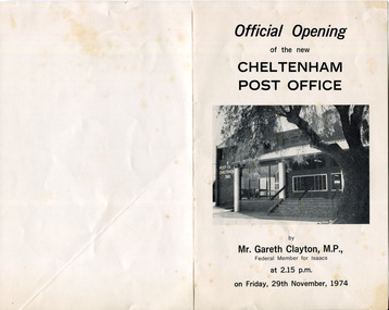
Document - Program Official Opening Cheltenham Post Office, Government Printer, 1974
... building was built 1891 in Point Nepean Road for the official... building was built 1891 in Point Nepean Road for the official ...John Hitchen was the manager of the first Cheltenham Post Office that opened 1/8/1857 in a boot and shoe store. Mail was transported to and from St Kilda to Cheltenham by coach 6 days a week and an additional service twice weekly to Tootgarook via Frankston also by coach. 1868 Post office Savings Bank began operation and the Telegraph office was established at the Railway Station 1885. A new building was built 1891 in Point Nepean Road for the official Cheltenham Post Office and a new manual telephone exchange began 1899 with 24 subscribers. By 1909 100 subscribers, 1951 there were 1700 and in 1974 12,000 subscribers . Hence this new building was designed by Oscar A. T. Gimsey & Assoc. and built by T W Morris & Sons Mordialloc. Mr G Clayton Federal MP Isaacs, opened the Post Office with Moorabbin City Council Mayor C.R McHutchison, Mr WJB Pollock, Director Posts and Telegraphs, and hands the Key of the post Office to Mr L De Longville Postmaster.The Post Office was an integral part to the development and prosperity of the Cheltenham area as the area grew from pioneer settlers in the 1850's to flourishing market gardens c1900 and industrial diversity of 1974.Program for the 'Official Opening of the Cheltenham Post Office' November 29th 1974 with a black and white photo of the building.city of moorabbin, county of bourke, moorabbin roads board, parish of moorabbin, shire of moorabbin, henry dendy's special survey 1841, were j.b., bent thomas, o'shannassy john, king richard, charman s, highett william, ormond francis, maynard dennis, post office, telegraph, st kilda station, tootgarook, frankston, clayton g mhr, mchutchison r.p mayor, pollock w j b mp, market gardens, early settlers, horse coach, de longville l postmaster -
 Chelsea & District Historical Society Inc
Photograph - Aerial Photo of Chelsea, c 1923
... past. Street in photo are Station Street, Chelsea Road, Nepean... past. Street in photo are Station Street, Chelsea Road, Nepean ...Points of interest in the photo are Fox Theatre in Station Street and Masons Theatre on the corner of Chelsea Road and Station Street; Chelsea Railway Station with a goods train going past. Street in photo are Station Street, Chelsea Road, Nepean Highway, Thames Promenade, Bath Street and The Strand. Black and white aerial photo of Chelsea. chelsea, aerial photo, station street, chelsea road, the strand, bath street, fox theatre, masons theatre, chelsea railway station, thames promenade, nepean highway -
 Melbourne Tram Museum
Photograph - TMSV tour trams 217 & 164, Keith Stodden, 13/6/1988
... , Elizabeth St) and the East Brighton (Hawthorn Road and Nepean...) and the East Brighton (Hawthorn Road and Nepean Highway) Yields ...Photographs show trams S164 and X 217 on a TMSV tour 13/6/1988 at Haymarket junction (Royal Parade and Flemington Road, Elizabeth St) and the East Brighton (Hawthorn Road and Nepean Highway) Yields information about TMSV toursSet of two colour prints.tramways, trams, tmsv, tours, haymarket, east brighton, tram 217, tram 164 -
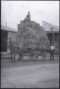
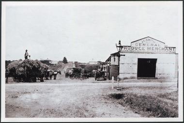 City of Moorabbin Historical Society (Operating the Box Cottage Museum)
Photograph, Black & White J. L. Smith Hay & Grain Store Bentleigh c1910, c1910
... Gates' on Point Nepean Road and Dendy Street. East Brighton... Nepean Road and Dendy Street. East Brighton. At that time ...John Logan Smith 1860-1932 , the son of Irish immigrants James and Marianne Smith was born at their home near the 'Toll Gates' on Point Nepean Road and Dendy Street. East Brighton. At that time the area had many orchards that were later replaced by market gardens. J.L.Smith at first rented a cottage 'Law Muir Den' & Shed from Mr Box and commenced business as a wood merchant - sawing logs into shorter pieces using one horse to power the saw. He purchased the property, added to the buildings , began trading in fuel and fodder as well and installed a chaff cutting mill powered by 10hp steam engine. The business prospered 1909 following the death of Tommy Bent, J/L Smith was nominated for Councillor of the Shire of Moorabbin. WW1 1914 - 18 both John and Mary Ann supported local War Relief Auxiliaries and their son Vic served as a Signaler in AIF. As Motor transport was increasing 1926 J L Smith built a small Garage on the opposite corner (Woolworths Supermarket 2005) , employed a good mechanic ( Reg Hunt ) and developed another successful business. The Grain Store was managed by family until 1930. In 1932 JL Smith assisted a man whose car had broken down, pushing it to the garage and sadly suffered a heart attack and died. He is buried in Cheltenham Cemetery. J.L.Smith was an early settler in East Brighton now Bentleigh and established successful Wood cutting, Grain & Chaff cutting and Motor garage businesses in Centre Road . He was elected Councillor of the Shire of Moorabbin and, with Mary Ann, his family were involved with local Church, Red Cross, and other community organizations.Black & white photograph of the Hay & Grain Store of John Logan Smith 1860-1932 on the corner of Jasper Rd and Centre Rd Bentleigh ( East Brighton) c1910. A Horse drawn cart loaded with hay and another outside the first building used by J L Smith -
 City of Moorabbin Historical Society (Operating the Box Cottage Museum)
Photograph, Black & White, J.L.Smith Hay & Grain Store c1916 Bentleigh, 1916
... Gates' on Point Nepean Road and Dendy Street. East Brighton... Nepean Road and Dendy Street. East Brighton. At that time ...John Logan Smith 1860-1932 , the son of Irish immigrants James and Marianne Smith was born at their home near the 'Toll Gates' on Point Nepean Road and Dendy Street. East Brighton. At that time the area had many orchards that were later replaced by market gardens. J.L.Smith at first rented a cottage 'Law Muir Den' & Shed from Mr Box and commenced business as a wood merchant - sawing logs into shorter pieces using one horse to power the saw. He purchased the property, added to the buildings , began trading in fuel and fodder as well and installed a chaff cutting mill powered by 10hp steam engine. The business prospered 1909 following the death of Tommy Bent, J/L Smith was nominated for Councillor of the Shire of Moorabbin. WW1 1914 - 18 both John and Mary Ann supported local War Relief Auxiliaries and their son Vic served as a Signaler in AIF. As Motor transport was increasing 1926 J L Smith built a small Garage on the opposite corner (Woolworths Supermarket 2005) , employed a good mechanic ( Reg Hunt ) and developed another successful business. The Grain Store was managed by family until 1930. In 1932 JL Smith assisted a man whose car had broken down, pushing it to the garage and sadly suffered a heart attack and died. He is buried in Cheltenham Cemetery J.L.Smith was an early settler in East Brighton now Bentleigh and established successful Wood cutting, Grain & Chaff cutting and Motor garage businesses in Centre Road . He was elected Councillor of the Shire of Moorabbin and, with Mary Ann, his family were involved with local Church, Red Cross, and other community organizations.Black & White photograph of J L Smith Hay & Grain Store and Crushing Mill Jasper Rd / Centre Rd Bentleigh 1916. A veranda has been added to the store, new signage attached and a Gas light and hitching post are in foreground. 3 Horse drawn carts loaded with grain bags and drivers sitting on top of loadV. Smithgas street light, hitching posts, smith vic, photography, smith j l; smith mary ann, stanley helen, smith vic, smith harry redvers, chaff cutter, horse drawn carts, toll gates brighton, motor cars 1900, steam engines, early settlers, bentleigh, parish of moorabbin, city of moorabbin, county of bourke, moorabbin roads board, shire of moorabbin, henry dendy's special survey 1841, were j.b.; bent thomas, o'shannassy john, king richard, charman s, highett william, ormond francis, maynard dennis, market gardeners, vineyards, orchards -
 City of Moorabbin Historical Society (Operating the Box Cottage Museum)
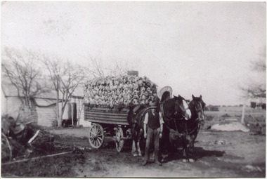
Photographs, x 2 ,Black & White, F Smith Horse drawn cart loaded, Baled Straw, Grain, c1920
... Gates' on Point Nepean Road and Dendy Street. East Brighton... Nepean Road and Dendy Street. East Brighton. At that time ...John Logan Smith 1860-1932 , the son of Irish immigrants James and Marianne Smith was born at their home near the 'Toll Gates' on Point Nepean Road and Dendy Street. East Brighton. At that time the area had many orchards that were later replaced by market gardens. J.L.Smith at first rented a cottage 'Law Muir Den' & Shed from Mr Box and commenced business as a wood merchant - sawing logs into shorter pieces using one horse to power the saw. He purchased the property, added to the buildings , began trading in fuel and fodder as well and installed a chaff cutting mill powered by 10hp steam engine. The business prospered 1909 following the death of Tommy Bent, J/L Smith was nominated for Councillor of the Shire of Moorabbin. WW1 1914 - 18 both John and Mary Ann supported local War Relief Auxiliaries and their son Vic served as a Signaler in AIF. As Motor transport was increasing 1926 J L Smith built a small Garage on the opposite corner (Woolworths Supermarket 2005) , employed a good mechanic ( Reg Hunt ) and developed another successful business. The Grain Store was managed by family until 1930. In 1932 J L Smith assisted a man whose car had broken down, pushing it to the garage and sadly suffered a heart attack and died. He is buried in Cheltenham Cemetery. J.L.Smith was an early settler in East Brighton now Bentleigh and established successful Wood cutting, Grain & Chaff cutting and Motor garage businesses in Centre Road . He was elected Councillor of the Shire of Moorabbin and, with Mary Ann, his family were involved with local Church, Red Cross, and other community organizations.2 x Black & White photographs showing horse drawn carts loaded with (a) Hay and (b) bags of grain outside J.L.Smith Grain & Chaff Store Centre Rd Bentleigh c1920smith frank, smith arch, smith tom, smith j l; smith mary ann, stanley helen, smith vic, smith harry redvers, chaff cutter, horse drawn carts, toll gates brighton, motor cars 1900, steam engines, early settlers, bentleigh, parish of moorabbin, city of moorabbin, county of bourke, moorabbin roads board, shire of moorabbin, henry dendy's special survey 1841, were j.b.; bent thomas, o'shannassy john, king richard, charman s, highett william, ormond francis, maynard dennis, market gardeners, vineyards, orchards -
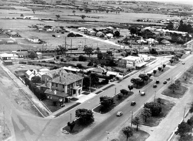 City of Kingston
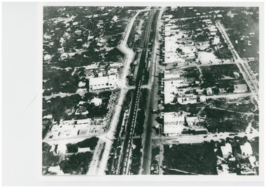
Photograph - Black and white, c. 1930
... of Nepean Highway and South Road. Moorabbin Council Chambers... of Nepean Highway and South Road. Moorabbin Council Chambers ...During the 1930s Moorabbin was an area with open grasslands, still often used for market gardening. The development of the city (and, later, suburb) can be seen emerging from the railway station.The Nepean Highway is a major highway running through the City of Kingston. This image is one of many that depicts its importance to the local community as it undergoes many changes over time.Black and white photograph of aerial view of intersection of Nepean Highway and South Road. Moorabbin Council Chambers are situated on the corner with the library, old shire building, Moorabbin railway station, St David's Anglican Church market gardens and open paddocks in the background.White round sticker on reverse with black printed text: 143 Handwritten in red ink on reverse: 156% / k000786moorabbin, council, railway station, railway, suburbs, paddocks, nepean highway -
 City of Moorabbin Historical Society (Operating the Box Cottage Museum)
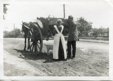
Photograph - Photograph, Black & White Mrs J.L.Smith & Butcher, 1915
... ' on Point Nepean Road and Dendy Street. East Brighton. At that time... at their home near the 'Toll Gates' on Point Nepean Road and Dendy ...The Butcher Mr Bill Ellin delivering meat to Mrs J.L.Smith in front of the house Law Muir Den 510 Centre Rd Bentleigh c 1915. Groceries, Ice, Milk, Bread, Eggs, Poultry were delivered to housewives by the traders in horse drawn carts, Also Hawkers and Pedlars plied their wares by visiting the cottages. John Logan Smith 1860-1932 , the son of Irish immigrants James and Marianne Smith was born at their home near the 'Toll Gates' on Point Nepean Road and Dendy Street. East Brighton. At that time the area had many orchards that were later replaced by market gardens. J.L.Smith at first rented a cottage 'Law Muir Den' & Shed from Mr Box and commenced business as a wood merchant - sawing logs into shorter pieces using one horse to power the saw. He purchased the property, added to the buildings , began trading in fuel and fodder as well and installed a chaff cutting mill powered by 10hp steam engine. The business prospered 1909 following the death of Tommy Bent, J/L Smith was nominated for Councillor of the Shire of Moorabbin. WW1 1914 - 18 both John and Mary Ann supported local War Relief Auxiliaries and their son Vic served as a Signaler in AIF. As Motor transport was increasing 1926 J L Smith built a small Garage on the opposite corner (Woolworths Supermarket 2005) , employed a good mechanic ( Reg Hunt ) and developed another successful business. The Grain Store was managed by family until 1930. In 1932 JL Smith assisted a man whose car had broken down, pushing it to the garage and sadly suffered a heart attack and died. He is buried in Cheltenham Cemetery. J.L.Smith was an early settler in East Brighton now Bentleigh and established successful Wood cutting, Grain & Chaff cutting and Motor garage businesses in Centre Road . He was elected Councillor of the Shire of Moorabbin and, with Mary Ann, his family were involved with local Church, Red Cross, and other community organizations.A Black and white photograph c 1915 showing the Butcher delivering meat to Mrs J.L Smith Bentleighsmith j l, smith mary ann, stanley helen, smith vic, smith harry redvers, chaff cutter, horse drawn carts, toll gates brighton, motor cars 1900, steam engines, early settlers, bentleigh, parish of moorabbin, city of moorabbin, county of bourke, moorabbin roads board, shire of moorabbin, henry dendy's special survey 1841, bent thomas, charman s, highett william, ormond francis, market gardeners, vineyards, orchards, william ellin, butcher -
 City of Moorabbin Historical Society (Operating the Box Cottage Museum)
Photograph, Black & White, V Peterson East Boundary Rd East Bentleigh loaded wagon c1900, original c1900
... the Plateways that ran along Centre Road and Nepean Highway. ... the Plateways that ran along Centre Road and Nepean Highway. The early ...The Peterson family were early settlers in Moorabbin Shire and established a market garden in East Boundary Road East Bentleigh. Vic Peterson and family loaded the crop - cabbages - onto the horse drawn wagon and set off to the Melbourne market using the Plateways that ran along Centre Road and Nepean Highway. The early settlers like the Petersons , in the Parish of Moorabbin County of Bourke after Henry Dendy's Special Survey Brighton 1841, established market gardens, fruit & flower gardens, poultry & dairy farms, vineyards as well as shop businesses, blacksmiths, chemists, nursing homes and schools & Churches.Black & White photograph showing Vic Peterson beside the horse drawn wagon loaded with 35dozen ( 12x 35) cabbages setting off to market c 1900 Original re-digitised by H Stanley 2005Back Hand written informationwagons, vulcan trucks, draught horses,, peterson vic, marriott dick, cabbage crops, vegetable crops, poliomyelitis epidemics 20thc , elster creek, plateways moorabbin shire, smith j l; smith mary ann, stanley helen, smith vic, smith harry redvers, chaff cutter, horse drawn carts, toll gates brighton, motor cars 1900, steam engines, early settlers, bentleigh, mckinnon, parish of moorabbin, city of moorabbin, county of bourke, moorabbin roads board, shire of moorabbin, henry dendy's special survey 1841, were j.b.; bent thomas, o'shannassy john, king richard, charman stephen, highett william, ormond francis, maynard dennis, market gardeners, vineyards, orchards -
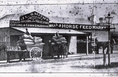
 City of Moorabbin Historical Society (Operating the Box Cottage Museum)
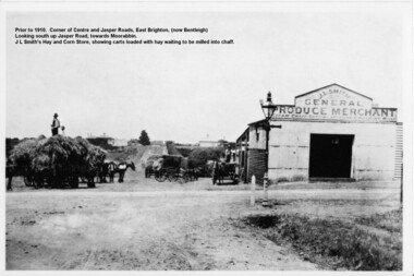
Photograph - Photograph Hay & Corn Store, Before 1910, Smith's Hay & Corn Store, Cnr. Centre and Jasper Roads, Bentleigh, Late 19th to early 20th Century
... is at the corner of Centre and Jasper Roads, East Brighton, (now known... in Point Nepean Road, Brighton, and Minnie was born in Patterson ...The first photograph was taken prior to 1910. The location is at the corner of Centre and Jasper Roads, East Brighton, (now known as Bentleigh). It is an early view of John L. and "Minnie" Smith's Hay and Corn Store, situated on the South West corner of those two roads. The first photo was taken prior to the introduction of electricity in the area. A gas lamp and horse "hitching post" can be seen "in shot". There are several loaded wagons waiting in line to have their hay milled to chaff. Farmers came from places as distant as Carrum to have their loads of hay milled into chaff. John Smith was born in 1860 in Point Nepean Road, Brighton, and Minnie was born in Patterson Road, Moorabbin, in a wattle and daub cottage with earthen floor and butter muslin over the windows. The couple married in 1884, Minnie was a devout Methodist and the family became very involved in the development of the local Methodist church. The couple had four children and during the 1890s Depression their first child died, they lost all their possessions, and John's family struggled to survive. Finally in the late 1890s JL Smith was able to rent a shed from Mr Henry Box on the corner of Centre and Jasper Roads, and he later purchased that property. With the gradual improvement in the economy, and the development of the successful market gardening industry in the Shire of Moorabbin, JL Smith's produce store became quite prosperous. Over some years the little "shed" developed into a thriving Hay and Corn Store. JL Smith went on to become Moorabbin Shire President in 1914. He and his wife were active in assisting soldiers returning injured from the 1st WW, in the local Methodist Church and other early community projects. Smith was a typical example of the majority of the early settlers in the Shire of Moorabbin, being god-fearing and devoted to the idea of service to the community. The photographs demonstrate the primitive conditions and early development of what is now a bustling and well-recognised area of Bentleigh, (known as east Brighton before 1907). The photo shows a gas lamp in use before the introduction of electricity in 1916. The Smith's story is representative of the many early pioneering traders, who elected to "set up shop", who suffered the adversity of the 1890s depression, but who survived and made their living in the largely undeveloped area of East Brighton ( now Bentleigh) district. Two black and white early photographs both of the same location. The photos are of the corner of Centre and Jasper Roads, Bentleigh. (Prior to 1907 this area was known as East Brighton.) Both photos show J.L Smith's General Merchant Produce store. "Steam Chaff Cutting and Corn Crushing Mills" and the surrounding area at differing stages. In the first photo taken prior to 1910, we can see there are several horse-drawn carts loaded with hay waiting to be milled, a gas lamp and a horse "hitching post". The store is just a single unadorned, shed. The later, second photo of the same area, shows improvements and the further development of that site. On the back of the photo "Hay and Corn Store -/ not later than 1910."/"Photographer /Victor C Smith,/ Phone Number XL1472"/hitching post, methodist church, smith minnie, moorabbin shire president, gas lamp, east brighton district, 1890s depression, wattle and daub cottage, centre road, jasper road, box henry, smith john l -
 Chelsea & District Historical Society Inc
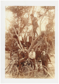
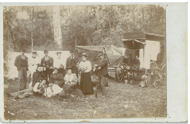
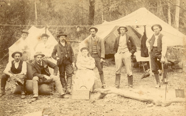
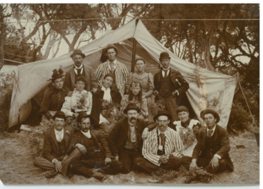
Photograph - Mr Alfred Morton with his brothers and friends, Bike picnic at Morton's property, c 1890
... provided by the Point Nepean Road (now the Nepean Highway... provided by the Point Nepean Road (now the Nepean Highway ...Alfred Louis Morton (known as Louis) was born in Geelong in 1866, the fifth of eleven children of Mark Morton and Eliza nee Heard (married 1898). Alfred began work for the Post Office at South Yarra in the 1890s. In the late 1800s it was common for people from Melbourne and north of the city to travel to Chelsea area beaches for their holidays and many liked the area so much that, like the Mortons, they moved here permanently. In the 1890s Alfred’s sister, Mrs William Ashmore, built a weekend house at the foot of what is now Foy Avenue in Chelsea. The Morton family, including Alfred, visited the area often, camping on the foreshore during the 1890s. In 1911 Alfred moved his family permanently to a house on the corner of Morton Grove and Main Road Chelsea (now known as the Nepean Highway) on property that extended from the main road to the beach. This house was destroyed in the fire of 22 December 1913 which raged amongst the ti-tree on the foreshore between Aspendale and Chelsea. Many buildings were destroyed in this fire. The Argus newspaper reported on Wednesday 24 December that 94 houses were burnt with glowing embers blown a mile and half inland. According to the Argus but for the wide break provided by the Point Nepean Road (now the Nepean Highway) and the railway line, the scrub on the other side might have caught. The Morton children, Elsa and Ivan, attended Chelsea State School (now Chelsea Primary School) and Mrs Morton was active in the establishment of St Chad’s Church of England in Chelsea. At the age of 80 in 1945 Mr Morton was concerned about reports that English children had lost their toys due to the war and so he made (as part of a wider effort in Australia) 100 toy engines that were sent to England. He died in 1946 in Chelsea. Sepia photograph of Mr Alfred Morton with his brothers in law and friend at Carrum in the 1890's, some perched in a tree others grouped at the base of the tree, bikes in the foreground.bike riding, picnic, morton, morton grove, chelsea, carrum -
 Chelsea & District Historical Society Inc
Photograph - Morton Family, Mr Alfred Morton with his mother and aunt, c 1866
... provided by the Point Nepean Road (now the Nepean Highway... provided by the Point Nepean Road (now the Nepean Highway ...Alfred Louis Morton (known as Louis) was born in Geelong in 1866, the fifth of eleven children of Mark Morton and Eliza nee Heard (married 1898). Alfred began work for the Post Office at South Yarra in the 1890s. In the late 1800s it was common for people from Melbourne and north of the city to travel to Chelsea area beaches for their holidays and many liked the area so much that, like the Mortons, they moved here permanently. In the 1890s Alfred’s sister, Mrs William Ashmore, built a weekend house at the foot of what is now Foy Avenue in Chelsea. The Morton family, including Alfred, visited the area often, camping on the foreshore during the 1890s. In 1911 Alfred moved his family permanently to a house on the corner of Morton Grove and Main Road Chelsea (now known as the Nepean Highway) on property that extended from the main road to the beach. This house was destroyed in the fire of 22 December 1913 which raged amongst the ti-tree on the foreshore between Aspendale and Chelsea. Many buildings were destroyed in this fire. The Argus newspaper reported on Wednesday 24 December that 94 houses were burnt with glowing embers blown a mile and half inland. According to the Argus but for the wide break provided by the Point Nepean Road (now the Nepean Highway) and the railway line, the scrub on the other side might have caught. The Morton children, Elsa and Ivan, attended Chelsea State School (now Chelsea Primary School) and Mrs Morton was active in the establishment of St Chad’s Church of England in Chelsea. At the age of 80 in 1945 Mr Morton was concerned about reports that English children had lost their toys due to the war and so he made (as part of a wider effort in Australia) 100 toy engines that were sent to England. He died in 1946 in Chelsea. Sepia photograph of Mr Alfred Morton as a baby, on the lap of his mother, Eliza, sitting on a chair, and his aunt, standing.morton, mr alfred louis morton -
 Chelsea & District Historical Society Inc
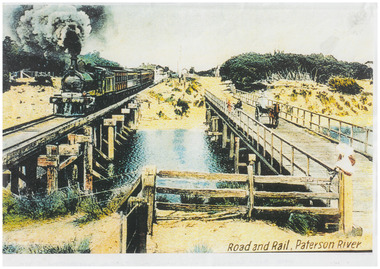
Photograph - Patterson River Postcards, Rail and Road Bridge, c 1905
... Two postcards of the road bridge (Nepean Highway... VICTORIA Two postcards of the road bridge (Nepean Highway ...The first bridge over the river was built in the early 1880's, prior to this it was a pontoon bridge. Dr. Sheldon's Magnetic Liniment was advertised as being able to relieve "at once rheumatism, lumbago, lame back, cuts, bruises or burns, will effect a cure in a remarkably short time. Price 1s 6d and 3s"Two postcards of the road bridge (Nepean Highway) with a horse and cart and people crossing and single line rail bridge , with a steam train crossing over Patterson River, near the mouth of the river. One card has been coloured, the other has been modified to advertise Dr Sheldon's Magnetic Liniment.DR SHELDON'S NEW DISCOVERY 16' & 3' BANISHES ALL PAINS AT CARRUM VICTORIApatterson river, road bridge, rail bridge, dr sheldon's linament, chelsea, steam train, transport, chelsea bridge, patterson bridge -
 Chelsea & District Historical Society Inc
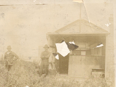
Photograph - Camping at Carrum, Morton Family, c 1890's
... provided by the Point Nepean Road (now the Nepean Highway... provided by the Point Nepean Road (now the Nepean Highway ...Mr Alfred Morton with his sisters, brothers and friends camping at Carrum in the 1890's. This area was later called Chelsea. Alfred Louis Morton (known as Louis) was born in Geelong in 1866, the fifth of eleven children of Mark Morton and Eliza nee Heard (married 1898). Alfred began work for the Post Office at South Yarra in the 1890s. In the late 1800s it was common for people from Melbourne and north of the city to travel to Chelsea area beaches for their holidays and many liked the area so much that, like the Mortons, they moved here permanently. In the 1890s Alfred’s sister, Mrs William Ashmore, built a weekend house at the foot of what is now Foy Avenue in Chelsea. The Morton family, including Alfred, visited the area often, camping on the foreshore during the 1890s. In 1911 Alfred moved his family permanently to a house on the corner of Morton Grove and Main Road Chelsea (now known as the Nepean Highway) on property that extended from the main road to the beach. This house was destroyed in the fire of 22 December 1913 which raged amongst the ti-tree on the foreshore between Aspendale and Chelsea. Many buildings were destroyed in this fire. The Argus newspaper reported on Wednesday 24 December that 94 houses were burnt with glowing embers blown a mile and half inland. According to the Argus but for the wide break provided by the Point Nepean Road (now the Nepean Highway) and the railway line, the scrub on the other side might have caught. The Morton children, Elsa and Ivan, attended Chelsea State School (now Chelsea Primary School) and Mrs Morton was active in the establishment of St Chad’s Church of England in Chelsea. At the age of 80 in 1945 Mr Morton was concerned about reports that English children had lost their toys due to the war and so he made (as part of a wider effort in Australia) 100 toy engines that were sent to England. He died in 1946 in Chelsea.Sepia photo of members of the Morton family camping at Carrum (now Chelsea). Tents and a wagon in the backgroundmorton, chelsea, carrum, post office, south yarra, camping, tents, wagon -
 Chelsea & District Historical Society Inc
Photograph - South Yarra Post Office, Group of Postal workers, c 1910's
... provided by the Point Nepean Road (now the Nepean Highway... provided by the Point Nepean Road (now the Nepean Highway ...Mr Alfred Morton with his sisters, brothers and friends camping at Carrum in the 1890's. This area was later called Chelsea. Alfred Louis Morton (known as Louis) was born in Geelong in 1866, the fifth of eleven children of Mark Morton and Eliza nee Heard (married 1898). Alfred began work for the Post Office at South Yarra in the 1890s. In the late 1800s it was common for people from Melbourne and north of the city to travel to Chelsea area beaches for their holidays and many liked the area so much that, like the Mortons, they moved here permanently. In the 1890s Alfred’s sister, Mrs William Ashmore, built a weekend house at the foot of what is now Foy Avenue in Chelsea. The Morton family, including Alfred, visited the area often, camping on the foreshore during the 1890s. In 1911 Alfred moved his family permanently to a house on the corner of Morton Grove and Main Road Chelsea (now known as the Nepean Highway) on property that extended from the main road to the beach. This house was destroyed in the fire of 22 December 1913 which raged amongst the ti-tree on the foreshore between Aspendale and Chelsea. Many buildings were destroyed in this fire. The Argus newspaper reported on Wednesday 24 December that 94 houses were burnt with glowing embers blown a mile and half inland. According to the Argus but for the wide break provided by the Point Nepean Road (now the Nepean Highway) and the railway line, the scrub on the other side might have caught. The Morton children, Elsa and Ivan, attended Chelsea State School (now Chelsea Primary School) and Mrs Morton was active in the establishment of St Chad’s Church of England in Chelsea. At the age of 80 in 1945 Mr Morton was concerned about reports that English children had lost their toys due to the war and so he made (as part of a wider effort in Australia) 100 toy engines that were sent to England. He died in 1946 in Chelsea.Black and white photo of postal works in front of the South Yarra Post Office. Members of the Morton family are in the group.morton, chelsea, carrum, post office, south yarra, postal workers -
 Chelsea & District Historical Society Inc
Photograph - Camping at Carrum, Morton Family, c 1890's
... provided by the Point Nepean Road (now the Nepean Highway... provided by the Point Nepean Road (now the Nepean Highway ...Mr Alfred Morton with his sisters, brothers and friends camping at Carrum in the 1890's. This area was later called Chelsea. Alfred Louis Morton (known as Louis) was born in Geelong in 1866, the fifth of eleven children of Mark Morton and Eliza nee Heard (married 1898). Alfred began work for the Post Office at South Yarra in the 1890s. In the late 1800s it was common for people from Melbourne and north of the city to travel to Chelsea area beaches for their holidays and many liked the area so much that, like the Mortons, they moved here permanently. In the 1890s Alfred’s sister, Mrs William Ashmore, built a weekend house at the foot of what is now Foy Avenue in Chelsea. The Morton family, including Alfred, visited the area often, camping on the foreshore during the 1890s. In 1911 Alfred moved his family permanently to a house on the corner of Morton Grove and Main Road Chelsea (now known as the Nepean Highway) on property that extended from the main road to the beach. This house was destroyed in the fire of 22 December 1913 which raged amongst the ti-tree on the foreshore between Aspendale and Chelsea. Many buildings were destroyed in this fire. The Argus newspaper reported on Wednesday 24 December that 94 houses were burnt with glowing embers blown a mile and half inland. According to the Argus but for the wide break provided by the Point Nepean Road (now the Nepean Highway) and the railway line, the scrub on the other side might have caught. The Morton children, Elsa and Ivan, attended Chelsea State School (now Chelsea Primary School) and Mrs Morton was active in the establishment of St Chad’s Church of England in Chelsea. At the age of 80 in 1945 Mr Morton was concerned about reports that English children had lost their toys due to the war and so he made (as part of a wider effort in Australia) 100 toy engines that were sent to England. He died in 1946 in Chelsea.Sepia photo of members of the Morton family camping at Carrum (now Chelsea).morton, chelsea, carrum, post office, south yarra, camping, tents -
 Chelsea & District Historical Society Inc
Photograph - Morton Family, Morton's house, Chlesea, pre 1913's
... provided by the Point Nepean Road (now the Nepean Highway... provided by the Point Nepean Road (now the Nepean Highway ...Mr Alfred Morton with his sisters, brothers and friends camping at Carrum in the 1890's. This area was later called Chelsea. Alfred Louis Morton (known as Louis) was born in Geelong in 1866, the fifth of eleven children of Mark Morton and Eliza nee Heard (married 1898). Alfred began work for the Post Office at South Yarra in the 1890s. In the late 1800s it was common for people from Melbourne and north of the city to travel to Chelsea area beaches for their holidays and many liked the area so much that, like the Mortons, they moved here permanently. In the 1890s Alfred’s sister, Mrs William Ashmore, built a weekend house at the foot of what is now Foy Avenue in Chelsea. The Morton family, including Alfred, visited the area often, camping on the foreshore during the 1890s. In 1911 Alfred moved his family permanently to a house on the corner of Morton Grove and Main Road Chelsea (now known as the Nepean Highway) on property that extended from the main road to the beach. This house was destroyed in the fire of 22 December 1913 which raged amongst the ti-tree on the foreshore between Aspendale and Chelsea. Many buildings were destroyed in this fire. The Argus newspaper reported on Wednesday 24 December that 94 houses were burnt with glowing embers blown a mile and half inland. According to the Argus but for the wide break provided by the Point Nepean Road (now the Nepean Highway) and the railway line, the scrub on the other side might have caught. The Morton children, Elsa and Ivan, attended Chelsea State School (now Chelsea Primary School) and Mrs Morton was active in the establishment of St Chad’s Church of England in Chelsea. At the age of 80 in 1945 Mr Morton was concerned about reports that English children had lost their toys due to the war and so he made (as part of a wider effort in Australia) 100 toy engines that were sent to England. He died in 1946 in Chelsea.Sepia photo of Mr Alfred Morton and his friend, Mr Doug Campbell at his holiday house, in what was to become Morton Grove, Chelsea. morton, chelsea, carrum, morton grove, holiday house -
 Chelsea & District Historical Society Inc
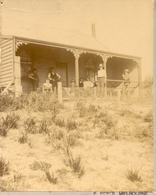
Photograph - Morton Family, Mrs Williams house in Foy Avenue, Chelsea, c 1890's
... provided by the Point Nepean Road (now the Nepean Highway... provided by the Point Nepean Road (now the Nepean Highway ...Mr Alfred Morton with his sisters, brothers and friends camping at Carrum in the 1890's. This area was later called Chelsea. Alfred Louis Morton (known as Louis) was born in Geelong in 1866, the fifth of eleven children of Mark Morton and Eliza nee Heard (married 1898). Alfred began work for the Post Office at South Yarra in the 1890s. In the late 1800s it was common for people from Melbourne and north of the city to travel to Chelsea area beaches for their holidays and many liked the area so much that, like the Mortons, they moved here permanently. In the 1890s Alfred’s sister, Mrs William Ashmore, built a weekend house at the foot of what is now Foy Avenue in Chelsea. The Morton family, including Alfred, visited the area often, camping on the foreshore during the 1890s. In 1911 Alfred moved his family permanently to a house on the corner of Morton Grove and Main Road Chelsea (now known as the Nepean Highway) on property that extended from the main road to the beach. This house was destroyed in the fire of 22 December 1913 which raged amongst the ti-tree on the foreshore between Aspendale and Chelsea. Many buildings were destroyed in this fire. The Argus newspaper reported on Wednesday 24 December that 94 houses were burnt with glowing embers blown a mile and half inland. According to the Argus but for the wide break provided by the Point Nepean Road (now the Nepean Highway) and the railway line, the scrub on the other side might have caught. The Morton children, Elsa and Ivan, attended Chelsea State School (now Chelsea Primary School) and Mrs Morton was active in the establishment of St Chad’s Church of England in Chelsea. At the age of 80 in 1945 Mr Morton was concerned about reports that English children had lost their toys due to the war and so he made (as part of a wider effort in Australia) 100 toy engines that were sent to England. He died in 1946 in Chelsea.Sepia photo of members of the Morton family on the verandah of Mrs William's house, Foy Avenue Chelsea.morton, chelsea, carrum, verandah, mrs williams -
 Chelsea & District Historical Society Inc
Photograph - Morton Family, After the 1913 fires in Chelsea, c 1913
... provided by the Point Nepean Road (now the Nepean Highway... provided by the Point Nepean Road (now the Nepean Highway ...Mr Alfred Morton with his sisters, brothers and friends camping at Carrum in the 1890's. This area was later called Chelsea. Alfred Louis Morton (known as Louis) was born in Geelong in 1866, the fifth of eleven children of Mark Morton and Eliza nee Heard (married 1898). Alfred began work for the Post Office at South Yarra in the 1890s. In the late 1800s it was common for people from Melbourne and north of the city to travel to Chelsea area beaches for their holidays and many liked the area so much that, like the Mortons, they moved here permanently. In the 1890s Alfred’s sister, Mrs William Ashmore, built a weekend house at the foot of what is now Foy Avenue in Chelsea. The Morton family, including Alfred, visited the area often, camping on the foreshore during the 1890s. In 1911 Alfred moved his family permanently to a house on the corner of Morton Grove and Main Road Chelsea (now known as the Nepean Highway) on property that extended from the main road to the beach. This house was destroyed in the fire of 22 December 1913 which raged amongst the ti-tree on the foreshore between Aspendale and Chelsea. Many buildings were destroyed in this fire. The Argus newspaper reported on Wednesday 24 December that 94 houses were burnt with glowing embers blown a mile and half inland. According to the Argus but for the wide break provided by the Point Nepean Road (now the Nepean Highway) and the railway line, the scrub on the other side might have caught. The Morton children, Elsa and Ivan, attended Chelsea State School (now Chelsea Primary School) and Mrs Morton was active in the establishment of St Chad’s Church of England in Chelsea. At the age of 80 in 1945 Mr Morton was concerned about reports that English children had lost their toys due to the war and so he made (as part of a wider effort in Australia) 100 toy engines that were sent to England. He died in 1946 in Chelsea.Sepia photo of members of the Morton family sitting on their land after the fires in Chelsea, 1913.morton, chelsea, carrum, verandah, fires -
 Chelsea & District Historical Society Inc
Photograph - Mr Morton in uniform, late 1880's
... provided by the Point Nepean Road (now the Nepean Highway... provided by the Point Nepean Road (now the Nepean Highway ...Mr Alfred Morton with his sisters, brothers and friends camping at Carrum in the 1890's. This area was later called Chelsea. Alfred Louis Morton (known as Louis) was born in Geelong in 1866, the fifth of eleven children of Mark Morton and Eliza nee Heard (married 1898). Alfred began work for the Post Office at South Yarra in the 1890s. In the late 1800s it was common for people from Melbourne and north of the city to travel to Chelsea area beaches for their holidays and many liked the area so much that, like the Mortons, they moved here permanently. In the 1890s Alfred’s sister, Mrs William Ashmore, built a weekend house at the foot of what is now Foy Avenue in Chelsea. The Morton family, including Alfred, visited the area often, camping on the foreshore during the 1890s. In 1911 Alfred moved his family permanently to a house on the corner of Morton Grove and Main Road Chelsea (now known as the Nepean Highway) on property that extended from the main road to the beach. This house was destroyed in the fire of 22 December 1913 which raged amongst the ti-tree on the foreshore between Aspendale and Chelsea. Many buildings were destroyed in this fire. The Argus newspaper reported on Wednesday 24 December that 94 houses were burnt with glowing embers blown a mile and half inland. According to the Argus but for the wide break provided by the Point Nepean Road (now the Nepean Highway) and the railway line, the scrub on the other side might have caught. The Morton children, Elsa and Ivan, attended Chelsea State School (now Chelsea Primary School) and Mrs Morton was active in the establishment of St Chad’s Church of England in Chelsea. At the age of 80 in 1945 Mr Morton was concerned about reports that English children had lost their toys due to the war and so he made (as part of a wider effort in Australia) 100 toy engines that were sent to England. He died in 1946 in Chelsea.Sepia photo Mr Morton in Fireman Uniformmorton, chelsea, carrum, fireman uniform -
 Chelsea & District Historical Society Inc
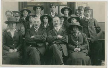
Photograph - South Yarra Post Office, Group of Postal workers
... provided by the Point Nepean Road (now the Nepean Highway... provided by the Point Nepean Road (now the Nepean Highway ...Mr Alfred Morton with his sisters, brothers and friends camping at Carrum in the 1890's. This area was later called Chelsea. Alfred Louis Morton (known as Louis) was born in Geelong in 1866, the fifth of eleven children of Mark Morton and Eliza nee Heard (married 1898). Alfred began work for the Post Office at South Yarra in the 1890s. In the late 1800s it was common for people from Melbourne and north of the city to travel to Chelsea area beaches for their holidays and many liked the area so much that, like the Mortons, they moved here permanently. In the 1890s Alfred’s sister, Mrs William Ashmore, built a weekend house at the foot of what is now Foy Avenue in Chelsea. The Morton family, including Alfred, visited the area often, camping on the foreshore during the 1890s. In 1911 Alfred moved his family permanently to a house on the corner of Morton Grove and Main Road Chelsea (now known as the Nepean Highway) on property that extended from the main road to the beach. This house was destroyed in the fire of 22 December 1913 which raged amongst the ti-tree on the foreshore between Aspendale and Chelsea. Many buildings were destroyed in this fire. The Argus newspaper reported on Wednesday 24 December that 94 houses were burnt with glowing embers blown a mile and half inland. According to the Argus but for the wide break provided by the Point Nepean Road (now the Nepean Highway) and the railway line, the scrub on the other side might have caught. The Morton children, Elsa and Ivan, attended Chelsea State School (now Chelsea Primary School) and Mrs Morton was active in the establishment of St Chad’s Church of England in Chelsea. At the age of 80 in 1945 Mr Morton was concerned about reports that English children had lost their toys due to the war and so he made (as part of a wider effort in Australia) 100 toy engines that were sent to England. He died in 1946 in Chelsea.Sepia photo of nine postal workers at South Yarra Post Office. They are wearing hats each with a different number, some have postal bags and some with letters in their hands. Mr Morton is the only one not wearing a hat.morton, chelsea, carrum, post office, south yarra, postal workers, postal uniform -
 Chelsea & District Historical Society Inc
Photograph - South Yarra Post Office, Postal workers
... provided by the Point Nepean Road (now the Nepean Highway... provided by the Point Nepean Road (now the Nepean Highway ...Mr Alfred Morton with his sisters, brothers and friends camping at Carrum in the 1890's. This area was later called Chelsea. Alfred Louis Morton (known as Louis) was born in Geelong in 1866, the fifth of eleven children of Mark Morton and Eliza nee Heard (married 1898). Alfred began work for the Post Office at South Yarra in the 1890s. In the late 1800s it was common for people from Melbourne and north of the city to travel to Chelsea area beaches for their holidays and many liked the area so much that, like the Mortons, they moved here permanently. In the 1890s Alfred’s sister, Mrs William Ashmore, built a weekend house at the foot of what is now Foy Avenue in Chelsea. The Morton family, including Alfred, visited the area often, camping on the foreshore during the 1890s. In 1911 Alfred moved his family permanently to a house on the corner of Morton Grove and Main Road Chelsea (now known as the Nepean Highway) on property that extended from the main road to the beach. This house was destroyed in the fire of 22 December 1913 which raged amongst the ti-tree on the foreshore between Aspendale and Chelsea. Many buildings were destroyed in this fire. The Argus newspaper reported on Wednesday 24 December that 94 houses were burnt with glowing embers blown a mile and half inland. According to the Argus but for the wide break provided by the Point Nepean Road (now the Nepean Highway) and the railway line, the scrub on the other side might have caught. The Morton children, Elsa and Ivan, attended Chelsea State School (now Chelsea Primary School) and Mrs Morton was active in the establishment of St Chad’s Church of England in Chelsea. At the age of 80 in 1945 Mr Morton was concerned about reports that English children had lost their toys due to the war and so he made (as part of a wider effort in Australia) 100 toy engines that were sent to England. He died in 1946 in Chelsea.Sepia photo of postal workers at South Yarra Post Office, corner of Toorak Road and Osborne Street, South Yarra. Mr Morton is standing at the counter, other workers are in the background .morton, chelsea, carrum, post office, south yarra, postal workers, postal uniform -
 Chelsea & District Historical Society Inc
Photograph - South Yarra Post Office
... provided by the Point Nepean Road (now the Nepean Highway... provided by the Point Nepean Road (now the Nepean Highway ...Mr Alfred Morton with his sisters, brothers and friends camping at Carrum in the 1890's. This area was later called Chelsea. Alfred Louis Morton (known as Louis) was born in Geelong in 1866, the fifth of eleven children of Mark Morton and Eliza nee Heard (married 1898). Alfred began work for the Post Office at South Yarra in the 1890s. In the late 1800s it was common for people from Melbourne and north of the city to travel to Chelsea area beaches for their holidays and many liked the area so much that, like the Mortons, they moved here permanently. In the 1890s Alfred’s sister, Mrs William Ashmore, built a weekend house at the foot of what is now Foy Avenue in Chelsea. The Morton family, including Alfred, visited the area often, camping on the foreshore during the 1890s. In 1911 Alfred moved his family permanently to a house on the corner of Morton Grove and Main Road Chelsea (now known as the Nepean Highway) on property that extended from the main road to the beach. This house was destroyed in the fire of 22 December 1913 which raged amongst the ti-tree on the foreshore between Aspendale and Chelsea. Many buildings were destroyed in this fire. The Argus newspaper reported on Wednesday 24 December that 94 houses were burnt with glowing embers blown a mile and half inland. According to the Argus but for the wide break provided by the Point Nepean Road (now the Nepean Highway) and the railway line, the scrub on the other side might have caught. The Morton children, Elsa and Ivan, attended Chelsea State School (now Chelsea Primary School) and Mrs Morton was active in the establishment of St Chad’s Church of England in Chelsea. At the age of 80 in 1945 Mr Morton was concerned about reports that English children had lost their toys due to the war and so he made (as part of a wider effort in Australia) 100 toy engines that were sent to England. He died in 1946 in Chelsea.Sepia photo of South Yarra Post Office, corner of Toorak Road and Osborne Street, South Yarra. Mr Morton and three other postal workers are standing at the front.morton, chelsea, carrum, post office, south yarra, postal workers, postal uniform -
 Chelsea & District Historical Society Inc
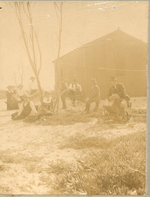
Photograph - Group of people camping at Carrum (Chelsea), c 1890
... provided by the Point Nepean Road (now the Nepean Highway... provided by the Point Nepean Road (now the Nepean Highway ...Mr Alfred Morton with his sisters, brothers and friends camping at Carrum in the 1890's. This area was later called Chelsea. Alfred Louis Morton (known as Louis) was born in Geelong in 1866, the fifth of eleven children of Mark Morton and Eliza nee Heard (married 1898). Alfred began work for the Post Office at South Yarra in the 1890s. In the late 1800s it was common for people from Melbourne and north of the city to travel to Chelsea area beaches for their holidays and many liked the area so much that, like the Mortons, they moved here permanently. In the 1890s Alfred’s sister, Mrs William Ashmore, built a weekend house at the foot of what is now Foy Avenue in Chelsea. The Morton family, including Alfred, visited the area often, camping on the foreshore during the 1890s. In 1911 Alfred moved his family permanently to a house on the corner of Morton Grove and Main Road Chelsea (now known as the Nepean Highway) on property that extended from the main road to the beach. This house was destroyed in the fire of 22 December 1913 which raged amongst the ti-tree on the foreshore between Aspendale and Chelsea. Many buildings were destroyed in this fire. The Argus newspaper reported on Wednesday 24 December that 94 houses were burnt with glowing embers blown a mile and half inland. According to the Argus but for the wide break provided by the Point Nepean Road (now the Nepean Highway) and the railway line, the scrub on the other side might have caught. The Morton children, Elsa and Ivan, attended Chelsea State School (now Chelsea Primary School) and Mrs Morton was active in the establishment of St Chad’s Church of England in Chelsea. At the age of 80 in 1945 Mr Morton was concerned about reports that English children had lost their toys due to the war and so he made (as part of a wider effort in Australia) 100 toy engines that were sent to England. He died in 1946 in Chelsea.Sepia photograph of a of Mr Alfred Morton with his sisters, brothers and friends camping at Carrum in the 1890's. bike riding, picnic, morton, morton grove, chelsea, carrum, camping -
 City of Moorabbin Historical Society (Operating the Box Cottage Museum)
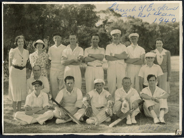
Photograph, Black & White, St Matthew's Church of England Cricket Team c 1940, c1940
... of England was erected in Cheltenham beside the Nepean Highway near... was erected in Cheltenham beside the Nepean Highway near Charman Road ...The Cheltenham parish was created in 1865 by excising a portion of the parish of St Andrews Brighton. A small brick church was completed in 1867 to serve a rural community stretching from Brighton South (Moorabbin) to Mordialloc. 1867 St Matthew's Church of England was erected in Cheltenham beside the Nepean Highway near Charman Road. The early settlers established a tennis club, cricket team and social groups.St Matthew's Church of England Cheltenham was erected in 1867 and was integral to the spiritual well being and social life of the early settlers.Black & White photograph of the St Matthews Church of England Cricket team Cheltenham c 1940Front ; Church of England Cricket Team 1940 Back ; Written - Ladies / Hilda Biehl, Bertha Schneeberber, Mrs Wootton, / We made afternoon tea from / a kerosene tin for 30 players / each Saturday they played at home !!smith j l; smith mary ann, stanley helen, chaff cutter, horse drawn carts, toll gates brighton, motor cars 1900, steam engines, early settlers, bentleigh, parish of moorabbin, city of moorabbin, county of bourke, moorabbin roads board, shire of moorabbin, henry dendy's special survey 1841, were j.b.; bent thomas, o'shannassy john, king richard, charman s, highett william, ormond francis, maynard dennis, market gardeners, vineyards, orchards, -
 City of Kingston
Photograph - Black and white, 20 December 1945
... at the intersection of Bay Road and Nepean Highway. A visible large parcel... Road and Nepean Highway. A visible large parcel of land ...This aerial photograph depicts the changing landscape of Cheltenham and Highett since WWII. Photographed in 1945, there is a mix of urban dwellings and industrial development and precedes the major transformation of Cheltenham with the development of the Southland shopping centre in the 1960s and expansion in the 1990s.A large part of Cheltenham was originally established as a rural market gardening community. The railway line and station brought urban development to the area and in the north, the Highett area was dominated by the Highett Gas Works. Cheltenham became a major destination for shopping in the 1960s with the opening of Southland.Aerial photograph taken in 1945 of Cheltenham and Highett within the City of Kingston. The image includes the Highett Reserve, (top right), the Methodist Children Homes (now Southland), Nepean Highway and Jamieson Street. Highett Gas Works is visible in the top left and the land now named William Fry Reserve at the intersection of Bay Road and Nepean Highway. A visible large parcel of land on the corner of Bay Road and Nepean Highway was developed in the 1990s as the west side addition to Southland. The densely vegetated area in the upper right sector of the image is now dense with housing. Tulip Grove, Heather Grove and Gilford Street are visible bottom left. This image is possibly from the collection of aerial photographs commissioned by the Department of Crown Lands and Survey and taken by Adastra Airways.Black ink: 57252 White lettering: VIC-10 57252 20.12.45 [lens information indecipherable] PROJ. No.5 MELB. METROP AREA Black pencil: 80highett, cheltenham, highett gas works, urbanisation -
 City of Kingston
Photograph - Black and white, 20 December 1945
... at the intersection of Bay Road and Nepean Highway. A visible large parcel... at the intersection of Bay Road and Nepean Highway. A visible large parcel ...This aerial photograph depicts the changing landscape of Cheltenham and Highett since WWII. Photographed in 1945, there is a mix of urban dwellings and industrial development and precedes the major transformation of Cheltenham with the development of the Southland shopping centre in the 1960s and expansion in the 1990s.A large part of Cheltenham was originally established as a rural market gardening community. The railway line and station brought urban development to the area and in the north, the Highett area was dominated by the Highett Gas Works. Cheltenham became a major destination for shopping in the 1960s with the opening of Southland.Aerial photograph taken in 1945 of Cheltenham and Highett within the City of Kingston. The image includes the Highett Reserve, (top right), the Methodist Children Homes (now Southland), Nepean Highway and Jamieson Street. Highett Gas Works is visible in the top left and the land now named William Fry Reserve at the intersection of Bay Road and Nepean Highway. A visible large parcel of land on the corner of Bay Road and Nepean Highway was developed in the 1990s as the west side addition to Southland. The densely vegetated area in the upper right sector of the image is now dense with housing. Tulip Grove, Heather Grove and Gilford Street are visible bottom left. This image is possibly from the collection of aerial photographs commissioned by the Department of Crown Lands and Survey and taken by Adastra Airways.Black type: Reverse lettering VIC-10 57252 20.12.45 [lens information indecipherable] PROJ. No.5 MELB. METROP AREA White lettering: Reverse writing 57252cheltenham, highett, highett gas works, urbanisation -
 City of Kingston
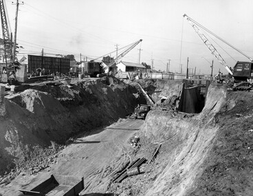
Photograph - Black and white, c. 1958
... with other construction works on Nepean Highway and South Road... with other construction works on Nepean Highway and South Road ...Moorabbin station sits on the Frankston line which first opened in 1882 when the line was extended from Mordialloc. Moorabbin station opened in 1881 and was originally called South Brighton station. It was renamed Moorabbin station in 1907. In 1958 the station was relocated below street level which coincided with other construction works on Nepean Highway and South Road. This image is part of a larger collection of images from the Public Transport Corporation displaying train stations and streetscapes in what is now the City of Kingston.Black and white photograph showing excavations for Moorabbin station to be moved below street level. Stamped in blue ink on reverse: COPYRIGHT / Public Transport Corporation / For re-ordering photographs / Please quote negative No M6004 / Enquiries C/- PTC Photographic Unit / Telephone switchboard 619 111moorabbin, railway station, construction works, suburbs, nepean highway