Showing 102 items
matching north-east vic
-
 Kew Historical Society Inc
Photograph - Yarra Valley at Kew, 1912
During the nineteenth century, the land abutting the south side of the Yarra in Kew was devoted to dairy farming. In the twentieth century, before and after the construction of the Eastern Freeway, much of this low-lying area was used as golf courses and public parks.Real-photo postcard of the farmland in the Yarra Valley in what is believed to be North Kew in 1912. Verso: "Willsmere / East Kew / 1912"yarra river, yarra valley, farming -- kew (vic.) -
 Kew Historical Society Inc
Photograph - Civic event in Stradbroke Park, 1976
Stradbroke Park. Extent: Kilby Road to Harp Road at Burke Road. Historical Documentation: 1851 - Portion 91 purchased by Edward Glynn; 1888 - The Harp of Erin Estate (which included Section 91) offered for sale; 1896 - The area now known as Stradbroke Park was bisected by a creek that flowed from the Yarra via Hay's Paddock (q.v.) and extended through to Burke Road; 1943 - W.D. Birrell, Town Clerk of Kew, proposed that the creek be filled and a reserve created; 1954 - Entire area designated as 'open space' and named 'Stradbroke Park'. The line of the creek that ran through the Park created a further reserve on the north side of High Street, now known as 'Harrison Reserve'. Existing Condition: The park is largely of mown grass that has mature trees set into it It is possible that a number of these are remnant of the original vegetation, while there are also a number of exotic trees introduced, particularly at the northern end of the park. The southern end is dominated by playing fields. (Source: Sanderson, P 1988. Kew Conservation Study)Colour photographic positive (with colour degradation) of sporting teams at a civic event in Stradbroke Park in Kew East in May 1976. The event was officiated by the Mayor of Kew, Cr Alan Hutchinson. Sporting teams in uniform included: footballers, athletes, cricketers, hockey players. Stradbroke Park is situated on the western boundary of Kew at Burke and Harp Roads.stradbroke park, cr alan hutchinson, team sports -- kew (vic.) -
 Kew Historical Society Inc
Photograph - Civic event in Stradbroke Park, 1976
Stradbroke Park. Extent: Kilby Road to Harp Road at Burke Road. Historical Documentation: 1851 - Portion 91 purchased by Edward Glynn; 1888 - The Harp of Erin Estate (which included Section 91) offered for sale; 1896 - The area now known as Stradbroke Park was bisected by a creek that flowed from the Yarra via Hay's Paddock (q.v.) and extended through to Burke Road; 1943 - W.D. Birrell, Town Clerk of Kew, proposed that the creek be filled and a reserve created; 1954 - Entire area designated as 'open space' and named 'Stradbroke Park'. The line of the creek that ran through the Park created a further reserve on the north side of High Street, now known as 'Harrison Reserve'. Existing Condition: The park is largely of mown grass that has mature trees set into it It is possible that a number of these are remnant of the original vegetation, while there are also a number of exotic trees introduced, particularly at the northern end of the park. The southern end is dominated by playing fields. (Source: Sanderson, P 1988. Kew Conservation Study)Colour photographic positive (with colour degradation) of sporting teams at a civic event in Stradbroke Park in Kew East in May 1976. The event was officiated by the Mayor of Kew, Cr Alan Hutchinson. Stradbroke Park is situated on the western boundary of Kew and bordered by Burke and Harp Roads.stradbroke park, cr alan hutchinson, team sports -- kew (vic.) -
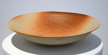 Federation University Art Collection
Ceramic, Roswitha Wulff, Woodfired Bowl by Roswitha Wulff, 1986, 1986
"I am an Australian of German parents born in Persia. I was taught by Peter Rushforth, with a very strong Japanese influence. My work attempts to incorporate these four elements of my history. For form, my influence comes from Art Nouveau, or Jugendstil as it is called in Germany. Techniques are informed by pottery from Japan, China, Korea and Germany. My colours are inspired by the Australian landscape. Using the language of woodfiring, I create a personal vocabulary with new subjects, grammar and syntax, which make each pot a one-off object containing all my diverse influences." (Roswitha Wulff)Roswitha WULFF (1941- ) Born Tabrize, Iran. Arrived Austrqalia c1949 Roswitha Wulff spent her early childhood with her mother, potter Helma Klett, in Germany. In 1964, she obtained a ceramics certificate from the East Sydney Technical College. From 1964-65, she worked with Robin Welch and Ian Sprague at Sprague's Mungeribar Pottery in Upper Beaconsfield, VIC. In 1966 she worked at the Sturt Pottery in Mittagong, NSW under Les Blakebrough. Between 1967 and 1969 Roswitha Wulff travelled overseas, spending 6 monthe with Robin Welch after his return to England and 9 months as a full-time thrower at Briglin Pottery, London, as well as working in potteries in Denmark and Germany. From 1969-70, she worked in North-West Pakistan as a research scholar for the Smithonian Institute and the University of NSW. Returning to Australia in 1970, she set up a workshop in Paddington, NSW, with the help of an Australia Council grant and taught part-time at the East Sydney Technical College and the Willoughby Workshop Art Centre. Since then she has been a lecturer and Head of Ceramics in many institutions, including the National Art School. In the 1990s she moved her studio to Botany Bay, NSW.. While working with the vessel form, she sees her pots as abstract landscapes. Recently she has also been working with wall tiles. During a residency at the Canberra School of Art in 2002, she developed tiles that looked like woodfired pillows with soft rounded rims. In 2007, she used such tiles to create a mural commemorating the Sesquicentenary of St Vincent's Hospital in Paddington. Woodfired stoneware bowl with flay ashSigned on baseroswitha wulff, jan feder, jan feder memorial ceramics collection, woodfire, ceramics, gippsland campus, botany bay studio pottery -
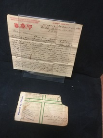 Mont De Lancey
Letter, 1945
Written by Robert Gaudion. Australian Military Forces - envelope.Letter to Mrs. T. Gaudion - 3 pages from her son Bob during Second World War. 3rd August 1945.Envelope addressed to Mrs. T. W. Gaudion, Wandin East Vic.letters, personal letters, correspondence -
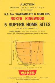 Ringwood and District Historical Society
Flyer, Land Auction, Cnr Warrandyte and Oban Roads, North Ringwood, Vic. - 1974
Single yellow page advertising Auction of five home sites to be sold separately on Saturday, 11th May, 1974. Details include vendor terms, subdivision services, and location map (north-east corner of Warrandyte and Oban Roads).(Agent) Eric Weber & Co. Pty. Ltd., 148 Wellington Parade, East Melbourne, 3002, Phone: 416025, Mr Elliott A.H. 8577502. Later handwritten notation suggests vendor was possibly Country Roads Board (VicRoads) after completion of road widening works. -
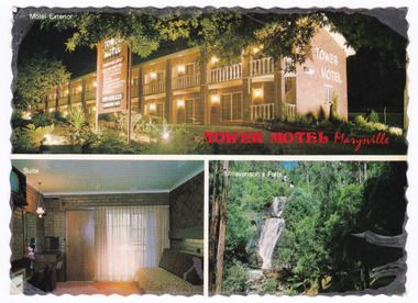 Marysville & District Historical Society
Postcard (item) - Colour postcard, Nucolorvue Productions Pty. Ltd, TOWER MOTEL Marysville, Unknown
A colour postcard from the Tower Motel in Marysville. The postcard was published by Nucolorvue as a souvenir of Marysville. The Tower Motel was one of the few buildings in Marysville that survived the 2009 Black Saturday bushfires.A colour postcard from the Tower Motel in Marysville. The postcard was published by Nucolorvue as a souvenir of Marysville.A/ NU-COLOR-VUE/ OF/ AUSTRALIA PLACE/ STAMP/ HERE POST CARD Product of Australia RP66 NUCOLORVUE PRODUCTIONS PTY. LTD./ COPYRIGHT TOWER MOTEL/ Murchison St., Marysville, Vic./ Phone (059) 63 3225 New luxury Motel, 100 km north/ east of Melbourne in the heart of/ the big timber country - just a/ short drive from the magnificent/ floodlit Steavenson's Falls - the/ tallest in Victoria. Units equipped with all modern/ facilities, including colour T.V. and/ air conditioning.marysville, victoria, australia, tower motel, accommodation, postcard, souvenir, nucolorvue productions pty. ltd., 2009 black saturday bushfires -
 Falls Creek Historical Society
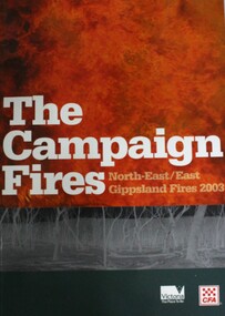
Book - The Campaign Fires - North-East/East Gippsland Fires 2003, Lyndel Hunter
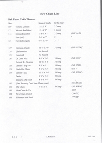
A description of efforts to fight the bushfires in Gippsland in 2003, including maps and illustrations. This volume was published as a tribute to the work of staff and volunteers who put themselves at risk to protect local communities. It shows the impact on those communities in Victoria and the support they gave to those involved in fighting largest bushfires in Victoria for 60 years. The Alpine bushfires started on 8th January 2003, a day of Total Fire Ban. Lightning ignited 87 fires in the North-East and East Gippsland regions. Eight of these fires were unable to be contained; they joined together to form the largest fire in Victoria since the Black Friday fires in 1939. The majority of the area burnt in Victoria was public land, 1.19 million hectares of parks and forests, including 60 per cent of the Alpine National Park and 81 per cent of the Mt Buffalo National Park. Firefighting efforts were made difficult in hard-to-access, remote forest terrain. Approximately 90,000 hectares of private land was burnt.This book is significant because it documents the 2003 Victorian Bushfires and serves as a tribute to the CFA staff and volunteers who fought them.This publication of 119 pages features text, colour images, maps and detailed information related to the 2003 bushfires in Victoria.At bottom of front cover:- CFA Victoria Logo Victorian Government Logovictorian fires 2003, cfa (vic) -
 Bendigo Historical Society Inc.
Document - NEW CHUM LINE OF REEF - REFERENCE TO CALEB THOMAS PLANS
Five pages of reference numbers used on Caleb Thomas plans. Has the mine's name, size of shaft and on other pages, the height of the sill. One mine on the Sheepshead Line, the New St Mungo is mentioned. Many mines along the reef are mentioned.document, gold, mines, new chum line of reef, reference to caleb thomas plans, catherine reef extd., new franklin, murchison, catherine reef united, catherine reef (south), acadia catherine, william's united, york & durham, belmont & saxby, ellenborough, sadowa, (old) st mungo, lady barkly, princess alice (sth st mungo), unicorn trib, pheonix, hopewell, united devonshire (princess alex), west united devonshire, east united devonshire, duchess of edinburgh, south devonshire, duchess tribute, new st mungo, new st mungo, new vict catherine, gt extd vict, herc new chum (late pearl), pearl south, north herc & energetic, herc & energetic, ironbark, vict consols, south new chum, lansell's 616, south belle vue, eureka extd, new chum rly, south old chum, new chum consolidated, ellesmere (south shaft), garibaldi, cravens, young chum, ellesmere nth shaft, new chum united, new chum vic, old chum, lazarus, cent new chum, lansell's 222, north old chum, lansell's big 180, advents advance, gt cent vict, hamboldt, ballerstedt, victoria quartz, herc & energetic, herc (old), shenandoah, victoria reef gold, victoria consols -
 Ringwood and District Historical Society
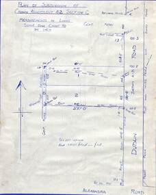
Drawing - Plan of Subdivision of Crown Allotment 42, Section C, Ringwood, Vic (Undated), Hand-drawn outline of residential allotments in Dublin Road north of Alexandra Road, Ringwood East, Victoria
Pen drawing on cardboard backing.