Showing 627 items matching "original plan"
-
 Robin Boyd Foundation
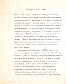
Document, Robin Boyd, Chapter XI - Campus Prospect
... Wilkinson in the late 1920s. Elements of Desbrowe-Annear's original... Wilkinson in the late 1920s. Elements of Desbrowe-Annear's original ...Boyd presents a thorough description of Harold Desbrowe-Annear's 1915 design for The University of Western Australia, Crawley with a focus on siting and how this was revised by Leslie Wilkinson in the late 1920s. Elements of Desbrowe-Annear's original layout plan that were retained, include the placement of the medical school and sporting facilities.Typewritten, carbon copy, foolscap, 12 pagesBlue pen mark up on pages 1, 2, 3, 4, 8, 9, 10, 11. Pencil mark up on pages 5, 6.university of western australia, crawley, harold desbrowe-annear, leslie wilkinson, talbot hobbs, professor whitfeld, w.b. hardwick, a.r.l. wright -
 Whitehorse Historical Society Inc.
Map, Schwerkolt property by Arthur Schwerkolt, 1993
... Map of Schwerkolt property and rough plan of original stone...,Schwerkolt Cottage Map of Schwerkolt property and rough plan ...Map of Schwerkolt property and rough plan of original stone house produced by Arthur Schwerkolt. Also copy of covering letterschwerkolt cottage -
 Buninyong Visitor Information Centre
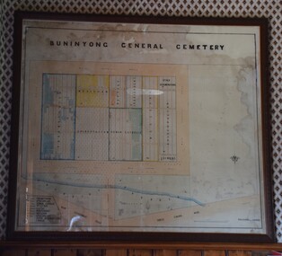
Plan - Cemetery Plan, Buninyong General Cemetery
... Framed and glazed original large hand drawn plan... and glazed original large hand drawn plan of the Buninyong General ...Plan of the complete layout of the Buninyong General Cemetery drawn by Robert [surname unclear] on 6 April 1871.Framed and glazed original large hand drawn plan of the Buninyong General Cemetery, showing the locations of denominational sections and plots. Buninyong General Cemeterycemeteries, historic sites, buninyong -
Glen Eira Historical Society
Letter - Gardenvale Road, 78, Gardenvale
... Breedon’s objections to the proposed plan. Copy of original plans... of original plans for the dwellings dated 12/09/2008. Copy of amended ...This file contains six items. Five items of typed correspondence concerning application to build four double-storey dwellings at 78 Gardenvale Road. Correspondence between City of Glen Eira and residents R.A. and P. Darke from 08/12/2008 to 20/03/2009, and Paul Siedle. Typed copy of resident Jonathon Breedon’s objections to the proposed plan. Copy of original plans for the dwellings dated 12/09/2008. Copy of amended plans for the four dwellings dated November 2008. Typed letter dated 20/03/2009 from Glen Eira Senior Town Planner to Richard and Peta Darke notifying of council’s decision of intention to grant a planning permit for the dwellings. Typed five page notice of decision to grant a planning permit for the four dwellings dated 20/03/09. Included is a one page description of the appeal process.gardenvale road, magnolia road, gardenvale, city of glen eira, city hall, glen eira road, hawthorn road, lloloma receptions, caulfield south, darke peta, darke richard, elster avenue, elsternwick, torres ron, kokkinos stella, glen eira city council, statutory planning department, breedon jonathon, lantana road, peter l. brown architects pty ltd., glen eira planning scheme, elsternwick library, bentleigh library, carnegie library, caulfield library, staniland grove, jasper road, shepparson avenue, bentleigh, carnegie, caulfield, siedle paul, townhouses, town planning, plans, aerial photographs, architectural drawings, architects, brick houses -
Port Melbourne Historical & Preservation Society
Document - File, Port Melbourne Yacht Club, 1970s - 1990s
... - including plans .02 - PMYC expansion report. Original 1976... - PMYC expansion report. Original 1976 including plans and photos ...Port Melbourne Yacht Club .01 -Sewerage connection 1975 - including plans .02 - PMYC expansion report. Original 1976 including plans and photos .03 - Rebuilding of clubhouse 1992. Including plans sport - yachting, built environment - recreational facilities -
 Kew Historical Society Inc
Plan - Subdivision Plan, Corsewall Estate, Hawthorn, 1938
... by the auctioneers. The original plan must have contained a photograph, which... by the auctioneers. The original plan must have contained a photograph, which ...The Kew Historical Society collection includes almost 100 subdivision plans pertaining to suburbs of the City of Melbourne. Most of these are of Kew, Kew East or Studley Park, although a smaller number are plans of Camberwell, Deepdene, Balwyn and Hawthorn. It is believed that the majority of the plans were gifted to the Society by persons connected with the real estate firm - J. R. Mathers and McMillan, 136 Cotham Road, Kew. The Plans in the collection are rarely in pristine form, being working plans on which the agent would write notes and record lots sold and the prices of these. The subdivision plans are historically significant examples of the growth of urban Melbourne from the beginning of the 20th Century up until the 1980s. A number of the plans are double-sided and often include a photograph on the reverse. A number of the latter are by noted photographers such as J.E. Barnes.This is a second, more complete version of the Corsewall Estate subdivision that is held by the Society. The Coreswall Estate was a subdivision, bordering on Barkers Road and Auburn Road, which created Corsewall Close. This relatively late subdivision included 29 allotments. The subdivision plan includes the dimensions of each lot as well as the width of the existing and projected roads and turning circles. The Corsewall Close Precinct is now listed on the Victorian Heritage Database (HO147) and is noted for its ‘consistent flat-type development over the entire street, which has been cleverly designed to make multi-unit dwellings appear as single buildings’. In this second version of the plan, the rarity of this late subdivision is emphasised by the auctioneers. The original plan must have contained a photograph, which is unfortunately truncated here.subdivision plans - hawthorn, corsewall estate -
Port Melbourne Historical & Preservation Society
Plan - Proposed Bayside development, Sep 1987
... Large plan of original proposed Bayside development.... This is the altered plan, with alterations drawn in red on the original ...SCDC plans for the Bayside development were revised as investigations into water circulation in artifical canals/harbour were completed. This is the altered plan, with alterations drawn in red on the original proposal, for the EES hearing in September 1987. The EES hearing, scheduled for three days in September, ran for 57 sessions into February 1988.Large plan of original proposed Bayside development as submitted to council in 1987; as 502.01 but with alterations superimposed in red, It was this altered plan that was submitted at the enquiry into the Environmental Effects Statement in September.In blue: EES Variation September 1987:In red: markings to indicate alterations to land configurationtown planning - proposals shelved - bayside, sandridge city development co pty ltd, scdc -
 Warrnambool and District Historical Society Inc.
Map - Warrnambool Port 1879, 1879
... and drawn up in 1879 was to accompany. The original plan.... The original plan was eventually modified because of the cost ...The port facilities in Warrnambool Bay were in constant use from the first years of Warrnambool’s settlement but there were also difficulties for the shipping trade – a small and unsafe anchorage, the lack of loading facilities and little natural protection from the southerly gales. From the 1870s on there was local agitation for some sort of Breakwater to be built and an Andrew Kerr design was approved by the Warrnambool Council but no funds were made available from the Victorian Government. Throughout the 1870s the building of a Breakwater was a major political issue in the district with preliminary work being funded and started in 1874. In 1879 the Government agreed to a further inspection of the area and an official report. Sir John Coode (1816-1892) was commissioned to make this report. He had come to Australia in 1872 to advise on harbour construction. Coode recommended a 1800 feet long Breakwater and wharf connected to the shore and it was this proposal that the plan described herein and drawn up in 1879 was to accompany. The original plan was eventually modified because of the cost and a Breakwater was completed in 1890 under the direction of the engineer, Arthur Dudley Dobson, with extensions early in the 20th century. This plan is of great interest as it shows in simple graphic form the original plans proposed by Sir John Coode for the Warrnambool Breakwater. It is therefore of great historical importance. The Breakwater was not the maritime success that it was hoped it would be but it is today a significant feature of our foreshore. This is a Plan drawn up in 1879 by Victorian Harbours to accompany Sir John Coode’s Report on the proposed Warrnambool Breakwater. The chart detail is hand-drawn and hand-tinted on canvas with the names of places, geographical and marine features and local points of interest added in print. The edges of the chart are rubbed and the chart is somewhat faded and dirty but the main colours of red, green and brown are still clearly discernible. The title of the plan is printed in an oval inset at the top of the chart. The plan shows two possible Breakwater designs, one from the Borough Surveyor (Andrew Kerr?) and one from Sir John Coode.Victorian Harbours Warrnambool Plan to accompany Sir John Coode’s report Dated 28th Feby 1879 warrnambool breakwater, andrew kerr, sir john coode, arthur dudley dobson, warrnambool, warrnambool harbour, warrnambool history, warrnambool beach -
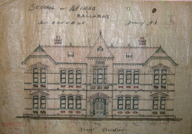
 Federation University Historical Collection
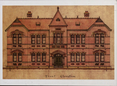
Plan - Postcard, Front Elevation of the Ballarat School of Mines New Classrooms (now Administration Building), 1898, 16/02/1899
... Postcard of the original hand coloured plan on linen... building architectural plans Postcard of the original hand coloured ...In 1900 this building was described as 'handsome in design, well lit, well ventilated, commodious - containing Council room, office, chemical laboratory, mineralogical laboratory, students room and six lecture rooms. Postcard of the original hand coloured plan on linen of the Ballarat School of Mines New Classrooms (from 2014 known as the Federation University Australia SMB campus Administration Building). The plan shows the front elevation, section on line, ground and 1st floor plan. ballarat school of mines, new classrooms, administration building, architectural plans -
 Federation University Historical Collection
Plan, Ballarat School of Mines New Classrooms (now Administration Building), 1899, 16/02/1899
... Original hand coloured plan on linen of the Ballarat School... building architectural plans a building Original hand coloured plan ...In 1900 this building was described as 'handsome in design, well lit, well ventilated, commodious - containing Council room, office, chemical laboratory, mineralogical laboratory, students room and six lecture rooms. Original hand coloured plan on linen of the Ballarat School of Mines New Classrooms (in 2014 known as the Federation University Australia SMB campus Administration Building). The plan shows the front elevation, section on line, ground and 1st floor plan. Copy in black frame with cream mount.ballarat school of mines, new classrooms, administration building, architectural plans, a building -
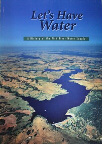 Wodonga & District Historical Society Inc
Book - Let's Have Water - A history of the Fish River Water Supply, Robin McLachlan, Denis Barrett, Jack Domis, Nick Welling, 1997
... construction began in the 1940s, but original plans have been extended... construction began in the 1940s, but original plans have been extended ...A history of the development of the management of the Fish River Water Supply Scheme in Central NSW. The scheme extends across the local government areas of the Shire of Oberon, the City of Lithgow and the City of the Blue Mountains.non-fictionA history of the development of the management of the Fish River Water Supply Scheme in Central NSW. The scheme extends across the local government areas of the Shire of Oberon, the City of Lithgow and the City of the Blue Mountains.water nsw, fish river region nsw, oberon dam, water resources development nsw australia -
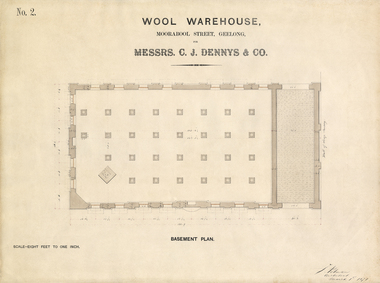
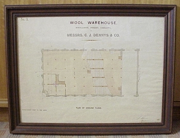
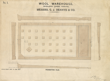 National Wool Museum
Plan - Architectural Plan, Wool Warehouse, Moorabool St, Geelong for Messrs C.J. Dennys & Co., Foundation Plan No. 1
... Original Jacob Pitman architectural plan of the Dennys...-and-the-bellarine-peninsula Original Jacob Pitman architectural plan ...Original Jacob Pitman architectural plan of the Dennys Lascelles bluestone woolstore dated 1 March 1871. Titled "Wool Warehouse, Moorabool St, Geelong for Messrs C.J. Dennys & Co., Foundation Plan No. 1".Wool Warehouse, Moorabool St, Geelong for Messrs C.J. Dennys & Co., Foundation Plan No. 1wool stores, pitman, mr jacob, dennys lascelles wool store -
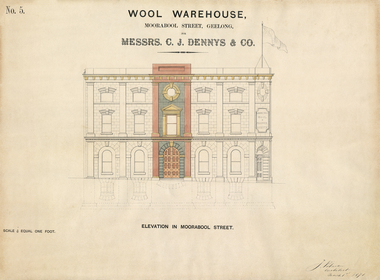 National Wool Museum
Architectural Plan, Wool Warehouse, Moorabool St, Geelong for Messrs C.J. Dennys & Co., Plan Elevation in Moorabool Street
... Original Jacob Pitman architectural plan of the Dennys...-and-the-bellarine-peninsula Original Jacob Pitman architectural plan ...Original Jacob Pitman architectural plan of the Dennys Lascelles bluestone woolstore dated 1 March 1871. Titled "Wool Warehouse, Moorabool St, Geelong for Messrs C.J. Dennys & Co., Plan Elevation in Moorabool Street".Wool Warehouse, Moorabool St, Geelong for Messrs C.J. Dennys & Co., Plan Elevation in Moorabool Streetwool stores, pitman, mr jacob, dennys lascelles wool store -
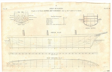 Flagstaff Hill Maritime Museum and Village
Drawing - Vessel Line Drawing, Ship Building Clipper Ship Schomberg, 1855-1876
... well-joined pieces of paper. The original plans would have been..., as it is made from two well-joined pieces of paper. The original plans ...This draft plan, a line etching, is of the wooden clipper ship "Schomberg" . It can be assumed from the heading "Ship Building." and the phrase "Built by Messrs. A Hall & Co. of Aberdeen" that the drawing is an example of plans for building a ship, and that the Schomberg ship has chosen to demonstrate this. The plan may have possibly been in a book, as it is made from two well-joined pieces of paper. The original plans would have been drawn up, discussed, reviewed and drawn in more detail before the building of the ship in Aberdeen, Scotland, in 1855. Information on the draft Is as follows: “Principal dimensions: Length between the perpendiculars: 262 feet 6 inches Length of keel 245 feet Breadth extreme: 45 feet Breadth of frame: 42 feet Depth of hold: 29 feet 9 inches Burthen in tons, Builders Old Measurement: 2600 Tons” The publisher firm A & C Black, was founded by Adam and Charles Black in Edinburgh in 1807. Over the years the company has published editions of Encyclopedia Britannica and Whose Who, and reference books, guides and technical books. The printer G Aikman (1788-1865) or his son G Aikman (1830-1905), were both named George. George senior was an early-19th century Scottish printer and publisher. After his death his son became the sole proprietor of the firm until he sold it in 1876. The draft plan uses the vessel Schomberg as its example ship building plan for demonstration purposes. It is significant for its association with the Victorian Heritage Registered shipwreck, the Schomberg. It is an example of a shipo building plan. The Schomberg collection is primarily significant because of the relationship between the objects, as together they have a high potential to interpret the story of the Schomberg. The Schomberg collection is archaeologically significant as the remains of an international passenger ship. The shipwreck collection is historically significant for representing aspects of Victoria’s shipping history and its potential to interpret sub-theme 1.5 of Victoria’s Framework of Historical Themes (living with natural processes). The collection is also historically significant for its association with the shipwreck and the ship, which was designed to be fastest and most luxurious of its day. The Schomberg collection meets the following criteria for assessment: Criterion A: Importance to the course, or pattern, of Victoria’s cultural history. Criterion B: Possession of uncommon, rare or endangered aspects of Victoria’s cultural history. Criterion C: Potential to yield information that will contribute to an understanding of Victoria’s cultural history.Plan; line engraving; draft of the wooden clipper ship 'Schomberg', built in 1855. The drawing on cream paper is made from two well- joined pages. The drawing gives the principal dimensions and labels for the Body Plan, Middle Section, Sheer Plan and Half Breadth Plan. Inscriptions are on the drawing and its rough cardboard storage folder. Publisher: A & C Black. Edinburgh. Printer: G. Aikman sc. EdinborughOn drawing: "SHIP BUILDING" "Draught of the Wooden CLIPPER SHIP SCHOMBERG", Buiilt by Messrs A Halt & Co. of Aberdeen" "Vol XX" "Plate III" "Principal Dimensions""BODY PLAN" "MIDDLE SECTION" "SHEER PLAN" "HALF BREDTH PLAN" "Published by A & C Black, Edinburgh" "G Aikman sc. Edinr" On storage folder: "Receipt Number 381A: "Line engraving draught of wooden ship "Schomberg" "warrnambool, flagstaff-hill-maritime-museum, shipwreck-coast, schomberg, schomberg plan, vessel schomberg, ship building, g. aikman ship plan draftsman, a.& c. black publisher aberdoon, a. hall & co. maker aberdeen, peterborough, clipper ship, captain forbes, black ball line, ship's plan, ship's drawing, line drawing, vessel plan, draft plan, line engraving, vol xx plate iii, a & c black, ship building example drawing, g aikman, 19th century -
 Parks Victoria - Mount Buffalo Chalet
Plans x 4, " Additions to Government Chalet Mt Buffalo
... Original plans for the Mount Buffalo Chalet, framed... Mount Buffalo National Park Mt Buffalo high-country Original ...Original plans for the Mount Buffalo Chalet, framed architectural drawings for the Chalet, titled " Additions to Government Chalet Mt Buffalo. Dated 1909. Signed Jas G Spence & E F Leary. "Ground Plan, first floor plan, elevation, Section M5 and side elevation –beautiful coloured plan, hand price onit of £970, also called Drawing No. 1.Beautiful plan suitable for reproduction for graphic work." (Pg 45. Heritage Impact Assessment, September 2013. MGS Architects and McDougall & Vines, Conservation and Heritage Consultants) 'The Mount Buffalo Chalet opened in April 1910 as a remarkable Victorian State government venture into alpine tourism and recreation. Designed by Public works Department architect, George Austin (1860-1921)." (Pg 4 Historica, 2011). "The collection of ephemera builds on the Chalet's holding of archival material with a range of interesting, original items. Dinner menus., stationery., luggage labels, tickets, dockets and plans help to interpret the structured routine and social conventions of the Chalet that held sway for so many years." (pg 127 MBCC) These plans drawn were most likely to have been drawn upon recommendation by Government Tourist Officer, J.C.Boyce. John Newton (the Lessee) suggests the addition of 2 new wings (24 rooms) and creation of a billiards room. Treasury approved money for these extensions which were not completed until1914. Listed in Draft Inventory of Significant Collection Items. Four framed hand-drawn and coloured drawings / plans of the Chalet. Framed and mounted behind glass. 1: Dated 1911 -1912. 2: -dated 6th oct 1909 3: -Dated 25th Sept 1909. 4: -Dated 6th Oct 1909.Handwritten at the top of each drawing," Mount Buffalo / Wood Chalet" -
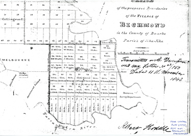 University of Melbourne, Burnley Campus Archives
Plan - Photocopy, Sketch of the Proposed Boundaries of the Village of Richmond, 1843
... site as "Reserve. Survey Department." original in Central Plan... site as "Reserve. Survey Department." original in Central Plan ...Sketch of the proposed boundaries of the village of Richmond in the County of Bourke Parish of Jika-Jika. Handwritten on original: "Transmitted with Description and my letter No 43/150 Dated 11th November 1843 Robert Hoddle." Shows Burnley Gardens site as "Reserve. Survey Department." original in Central Plan Office, Department of Natural Resources and EnvironmentIn ink: From Central Plan Office Dept. Nat. Resources & Environmentrichmond, jika-jika, survey department, yarra river, robert hoddle -
 National Wool Museum
Architectural Plan, Wool Warehouse, Moorabool St, Geelong for Messrs C.J. Dennys & Co., Basement Plan No. 2
... Original Jacob Pitman architectural plan of the Dennys...-and-the-bellarine-peninsula Original Jacob Pitman architectural plan ...Original Jacob Pitman architectural plan of the Dennys Lascelles bluestone woolstore dated 1 March 1871 mounted in a wood frame under glass. Titled "Wool Warehouse, Moorabool St, Geelong for Messrs C.J. Dennys & Co., Basement Plan No. 2."Wool Warehouse, Moorabool St, Geelong for Messrs C.J. Dennys & Co., Basement Plan No. 2wool stores, pitman, mr jacob, dennys lascelles wool store -
 National Wool Museum
Architectural Plan, Wool Warehouse, Moorabool St, Geelong for Messrs C.J. Dennys & Co., Ground Floor No. 3
... Original Jacob Pitman architectural plan of the Dennys...-and-the-bellarine-peninsula Original Jacob Pitman architectural plan ...Original Jacob Pitman architectural plan of the Dennys Lascelles bluestone woolstore dated 1 March 1871 mounted in a wood frame under glass. Titled "Wool Warehouse, Moorabool St, Geelong for Messrs C.J. Dennys & Co., Ground Floor No. 3".Wool Warehouse, Moorabool St, Geelong for Messrs C.J. Dennys & Co., Ground Floor No. 3wool stores, pitman, mr jacob, dennys lascelles wool store -
 Flagstaff Hill Maritime Museum and Village
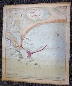
Document - Plan, Victorian Harbours Warrnambool, Victorian Harbours, Warrnambool, Plan to Accompany Sir John Coode's Report, 28-02-1879
... the Warrnambool Breakwater. His original plan was too expensive so he... the Warrnambool Breakwater. His original plan was too expensive so he ...This plan is of great significance to the local history of Warrnambool, in particular the Breakwater and its impact on Warrnambool's maritime and trade history. The plan shows the existing jetties at the Port of Warrnambool, plus the partially erected Breakwater and proposed works to the Breakwater by both the Borough of Warrnambool Surveyor and Sir John Coode. The plan was signed 28th February 1879 by Sir John Coode. The legend at the bottom left describes the existing works and the proposed works. The Warrnambool Breakwater Sir John Coode was a British harbour engineer. He was brought to Melbourne by the Melbourne Harbour Trust to advise on works to improve the Port of Melbourne. The Victorian Government commissioned him to present a plan to complete the Warrnambool Breakwater. His original plan was too expensive so he prepared a revised plan for a shorter structure. The work was completed in 1890. The construction proved to be too short to protect adequately from the weather and didn't allow enough depth for larger vessels to come into port. The decreasing trade was further affected by siltation in the bay due to the breakwater, and the completion of the railway line. The situation of the harbour became a real problem that, by 1910, required continuous dredging. In 1914 the Breakwater was extended but proved to be a failure because the work began to subside and by 1920 about two thirds of the harbour was silted up. Alterations made in the 1920's increased the silting problem and by the 1940's the harbour was no longer used. More alterations were made in the 1950's and 1960's. The Warrnambool Breakwater is registered as a place of significance on the Victorian Heritage Database. This plan of the proposed works for the existing Warrnambool Breakwater is of great significance to the local history of Warrnambool, in particular the Breakwater and its impact on Warrnambool's maritime and trade history. The Warrnambool Breakwater is registered as a place of significance on the Victorian Heritage Database (VHR H2024). It is historically significant to Victoria as one of the most important maritime engineering projects in Victoria in the late 19th century. The Warrnambool Breakwater is of historical significance as one of the most important maritime engineering projects in Victoria in the late nineteenth century. It is evidence of Victoria's nineteenth century investment in regional port infrastructure and the development of Victorian coastal shipping. It is of significance for its association with the English civil engineer Sir John Coode, the most distinguished harbour engineer of the nineteenth century, who was brought to Victoria to advise on works to improve the Port of Melbourne, but was retained by the Government to advise on improvements to the harbours at Portland, Geelong, Port Fairy, and Lakes Entrance, as well as Warrnambool. His projects for Melbourne, Lakes Entrance and Warrnambool were major engineering projects of the nineteenth century. The breakwater is historically significant as a reminder of Warrnambool's early maritime history as a Western District port, and as one of Victoria's major 'outer ports'. While the Warrnambool Breakwater is a demonstration of the engineering skills of the nineteenth century, it also demonstrates the limitations of knowledge relating to sedimentology at the time and the confidence apparent in a number of nineteenth century plans which assumed that natural forces could be overcome or contained by engineering.Plan of Warrnambool Harbour, Port of Warrnambool, dated 28 Feb 1879. Plan shows existing Breakwater and work proposed by both Warrnambool Borough Surveyor and Sir John Coode. Plan has gold coloured quarter-dowel rods top and bottom and a metal ring at the top. Stamped with title. Signed by Sir John Coode.Stamped "VICTORIAN HARBOURS / WARRNAMBOOL / PLAN / to accompany / SIR JOHN GOODE'S REPORT / DATED 28 FEB 1879" Signature "John Coode"flagstaff hill, warrnambool, maritime museum, shipwreck coast, great ocean road, sir john coode, borough of warrnambool surveyor, plan of warrnambool, victorian harbours, warrnambool harbour, warrnambool breakwater, port of warrnambool, vhd vhr h2024, flagstaff hill maritime museum & village, maritime village, map, chart, plan, lady bay, breakwater, jetty, pier, vhr h2024, proposed works, 1879 -
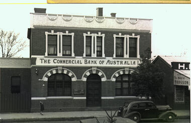 Bacchus Marsh & District Historical Society
Photograph, Commercial Bank of Australia Main Street Bacchus Marsh
... building is now in use as a newsagency. The original architectural... building is now in use as a newsagency. The original architectural ...The Commercial Bank of Australia building was constructed by J. F. Taylor in 1907 and shortly after commenced operations as a bank. The building was in use as a CBA bank until 1976 when it was demolished and a new building erected. The CBA continued its operations at this location; subsequently, various banks, such as the Bank of Melbourne and Westpac operated there. Part of the new building is now in use as a newsagency. The original architectural plans for this building designed by Walter Butler are held by the State Library of Victoria and can be viewed online through the Library's website: Citation: Butler, W. R., & Taylor, J. F. (1906). Design for banking premises at Bacchus Marsh for the Commercial Bank of Australia Ltd. URL: http://handle.slv.vic.gov.au/10381/473561 Black and white photographic print. Photograph of the Commercial Bank 138 Main Street Bacchus Marsh. On the left is a smaller brick building adjoining the bank. On the right there is a partial shot of a shop called The House of Hodgson. The bank building itself is shown as a substantial two-story brick building, the top storey appearing to be a dwelling with three ornamented windows furnished with curtains and blinds. The storeys are divided by a white panel bearing the words "The Commercial Bank of Australia Ltd". The lower storey has a central entrance with a panelled door. The door is flanked by two windows with reinforced lattices. The windows and door are surmounted by decorative arches reminiscent of Spanish Moorish architecture. A car (possibly a 1937 Dodge) is parked on the street. A lone girl stands on the footpath waving at the photographer.On the back: In pencil: 1937 Dodge?shops bacchus marsh vic., main street bacchus marsh vic., banks bacchus marsh vic., commercial bank of australia bacchus marsh -
Glen Eira Historical Society
Document - Grange Road, 77, Glen Huntly
... and the purchasers Mr & Mrs Hulbert Gorrie. 3/ The original blueprint plan... and the purchasers Mr & Mrs Hulbert Gorrie. 3/ The original blueprint plan ...This file contains 4 items about the purchase and construction of this property: 1/ The original contract of sale of land dated 25/09/1936 for Gertrude & Hulbert Gorrie situated on the corner of Grange and Neerim Road. 2/ The original typed building agreement dated 25/09/1936 between the contractor Ernest F Barnard and the purchasers Mr & Mrs Hulbert Gorrie. 3/ The original blueprint plan of a brick villa at the corner of Grange & Neerim Road for Mr & Mrs Hulbert Gorrie. Dated 25/09/1936. 4/ The original specification for the dwelling on the corner of Grange & Neerim Road, Glen Huntly for Mrs Gertrude Gorrie & Mr Hulbert Hopetoun Gorrie by builder Ernest F Barnard.barnard ernest f, gorrie gertrude, gorrie hulbert hopetoun, hobart john bertram, coorigil road, carnegie, holloway st, ormond, chemists, parish of prahran, caulfield county of bourke, building agreement, brick houses, builders, plans, architectural drawings, grange road, glen huntly, holloway street, ormond, emma street, grange road, neerim road, gorrie h.h, gorrie gertrude, gorrie hulbert h, legal documents, barnard ernest franklin, e. j. & h. amos, hintons nursery, real estate agents, murrumbeena, caulfield -
University of Melbourne, Burnley Campus Archives
Plan, Royal Botanic Gardens Melbourne, 1978
... ) Original coloured plan and reduced size photocopy. More labelling...) Original coloured plan and reduced size photocopy. More labelling ...Plan of RBG with grid references. Produced by Dept. of Crown Lands and Survey, Victoria, Division of Survey and Mapping. Prepared in 1978 from surveys completed in 1976. (1) 2 copies plan. Main areas, buildings, etc., labelled, beds outlined. (2) Original coloured plan and reduced size photocopy. More labelling, particularly beds (handwritten). Labelled Jeremy J. Wallace with handwritten notes on reverse re a project. (3) Reduced size photocopy. Handwritten labelling of beds. (4 - 11) Enlarged photocopies of sections of (1) Handwritten notes and plant labelling. (1). Photgraphed copies by FRESCO 510131-TA. (12) Plan on a grid, coloured. "No Public Access," areas marked.jeremy j. wallace, royal botanical gardens melbourne, department of crown land and survey division of survey and mapping, ornamental lakes -
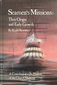 Mission to Seafarers Victoria
Book, Roald Kverndal, Seamen's Missions: Their origin and Early Growth. A contribution to the History of the Church Maritime, 1986
... during World War II. His original plan for a career in shipping... during World War II. His original plan for a career in shipping ...Hardback cover book with white Title (see above) and author text, KVERNDAL, Roald, on pink grey cover. pp 903, ills. Cover image depicts a masted galleon ship at anchor with interior lights at dusk or dawn flying from the stern of the ship is the blue BETHEL flag featuring a star and dove of peace in top and lwr corners respectively. xxviii, 903 p. : ill. ; 24 cmnon-fictionmerchant seamen, missions and charities, royal navy chaplains, missions-to-seamen, mission to seafarers, roald kverndal -
 Flagstaff Hill Maritime Museum and Village
Document - Navigation Chart, Admiralty Office, Lady Bay and Warrnambool Harbour, 1893
... to complete the Warrnambool Breakwater but his original plan was too... but his original plan was too expensive. He prepared a revised ...This navigation cart of Lady Bay and Warrnambool Harbour was originally surveyed in 1870 but this version includes the update for magnetic variation in 1893. Since the printing of the chart several annotations have been added. These include an additional stamp dated 15-8-1910, a handwritten comment across the top of the page dated August 1910, and another handwritten comment regarding the ‘Proposed Extension of Dock’ dated 19-2-1925, plus connected drawings, notes and figures. The 1925 proposal on this chart may have been a reaction to the Royal Commission of 1923, when the damaged stonework on the seaward side of the Warrnambool Breakwater, caused by the action of the sea, was the subject of enquiry. A conference between the Public Works, Water Commission and the Harbour Trust concluded that it would less costly to make repairs to prevent further damage rather than replaced the damage portion of the wall. A contract was raised in late 1924 to deposit rubble on the damaged side of the breakwater to minimise the Southern Ocean’s destructive action and work had started by August 1925. The Breakwater construction had begun in 1874 and was completed in 1890. The Victorian Government had commissioned Sir John Coode, a British harbour engineer, to present a plan to complete the Warrnambool Breakwater but his original plan was too expensive. He prepared a revised plan for a shorter structure. The construction proved to be too short to protect adequately from the weather and didn't allow enough depth for larger vessels to come into port. The decreasing trade was further affected by siltation in the bay due to the breakwater, and the completion of the railway line. The situation of the harbour became a real problem by 1910 and required continuous dredging. In 1914 the Breakwater was extended but proved to be a failure because the work began to subside and by 1920 about two thirds of the harbour was silted up. Alterations made in the 1920's increased the silting problem and by the 1940's the harbour was no longer used. More alterations were made in the 1950's and 1960's. This chart is significant for its strong connection to the maritime history of Warrnambool Harbour and Lady Bay and the Warrnambool Breakwater. The Warrnambool Breakwater is registered as a place of significance on the Victorian Heritage Database (VHR H2024). The Warrnambool Breakwater is one of the most important late 19th century maritime engineering projects in Victoria and significant in the development of Victorian coastal shipping. It is also significant for its connection with British harbour engineer, Sir John Coode. The chart is a historical record of structures existing in 1893; the Warrnambool Jetties, Warrnambool Breakwater in Lady Bay, the leading lights (lighthouses), streets, roads, bridges and many buildings. It also shows the lay of the land and seabed. Navigation Chart: Lady Bay and Warrnambool Harbour, Australia - South Coast - Victoria. Surveyed by Nav. Lieut. H.J. Stanley, R.N., 1870. Updated for Magnetic Variation, 1893. The rectangular chart is printed on heavy cream paper. Stamps are shaped rectangular, oval and round. Around the Breakwater and Jetty area are handwritten notes, dotted and joined lines, numbers and signatures, and shading of red and green. The chart shows the surrounds of Warrnambool Harbour, Lady Bay, the Breakwater and Jetty, roads, bridges and the streets in Warrnambool. It has sounding details, and angles of line from the leading lights.Stamp, rectangular, including "AUG 1910" Stamp, double oval " - - - -CHART" Stamp, hand drawn, red circle, with "B" inside Hand written note "22-8-1910 - - - - - of surveying C. Ca - - - request of 15-8-10 [initials] " Notes and lines in red pen, including a grid of sounding numbers: "1300" "1050" "1200" "Possible Extension of Dock" "19-2-25" "Dock Dredged to 20 Ft" Notes and lines in blue pen "Extension of Dock to accommodate vessels drawing 20 Feet" and "Light not visible south of this line" Red dots (4) with yellow highlight at both leading lights, breakwater and jettyflagstaff hill, warrnambool, flagstaff hill maritime museum & village, maritime museum, maritime village, shipwreck coast, map, chart, navigation chart, plan, lady bay, warrnambool harbour, port of warrnambool, breakwater, jetty, pier, dock extension, proposed extension, vhr h2024, 1870, 1893, 1910, 1925, warrnambool town late 1800s, warrnambool streets late 1800s royal commission, 1923, public works, water commission, harbour trust, victorian harbours, sir jon coode -
 Kew Historical Society Inc
Plan, Melbourne & Metropolitan Board of Works : Borough of Kew : Detail Plan No.1592, 1905
... Original survey plan, issued by the MMBW to a contractor... survey plans - borough of kew mmbw 1592 cartography Original ...The Melbourne and Metropolitan Board of Works (MMBW) plans were produced from the 1890s to the 1950s. They were crucial to the design and development of Melbourne's sewerage and drainage system. The plans, at a scale of 40 feet to 1 inch (1:480), provide a detailed historical record of Melbourne streetscapes and environmental features. Each plan covers one or two street blocks (roughly six streets), showing details of buildings, including garden layouts and ownership boundaries, and features such as laneways, drains, bridges, parks, municipal boundaries and other prominent landmarks as they existed at the time each plan was produced. (Source: State Library of Victoria). This plan forms part of a large group of MMBW plans and maps that was donated to the Society by the Mr Poulter, City Engineer of the City of Kew in 1989. Within this collection, thirty-five hand-coloured plans, backed with linen, are of statewide significance as they include annotations that provide details of construction materials used in buildings in the first decade of the 20th century as well as additional information about land ownership and usage. The copies in the Public Record Office Victoria and the State Library of Victoria are monochrome versions which do not denote building materials so that the maps in this collection are invaluable and unique tools for researchers and heritage consultants. A number of the plans are not held in the collection of the State Library of Victoria so they have the additional attribute of rarity.Original survey plan, issued by the MMBW to a contractor with responsibility for constructing sewers in the area identified on the plan within the Borough of Kew. The plan was at some stage hand-coloured, possibly by the contractor, but more likely by officers working in the Engineering Department of the Borough and later Town, then City of Kew. The hand-coloured sections of buildings on the plan were used to denote masonry or brick constructions (pink), weatherboard constructions (yellow), and public buildings (grey). In MMBW Plan No.1592, the pink line indicates that area of the plan for which the contracting engineer was responsible. Included in the Plan are a number of primarily brick villas in a section of Belmont Avenue off Cotham Road. The house ‘Uvadale’ north of Belmont Avenue, and facing Cotham Road is also included in the contract. Excluded from the contract but shown on the Plan are ‘Glendonald’, ‘Mont Belmont’ and ‘Gilden’.melbourne and metropolitan board of works, detail plans, survey plans - borough of kew, mmbw 1592, cartography -
 Kew Historical Society Inc
Plan, Melbourne & Metropolitan Board of Works : Borough of Kew : Detail Plan No.1561, 1905
... Original survey plan, issued by the MMBW to a contractor... mmbw 1561 cartography Original survey plan, issued by the MMBW ...The Melbourne and Metropolitan Board of Works (MMBW) plans were produced from the 1890s to the 1950s. They were crucial to the design and development of Melbourne's sewerage and drainage system. The plans, at a scale of 40 feet to 1 inch (1:480), provide a detailed historical record of Melbourne streetscapes and environmental features. Each plan covers one or two street blocks (roughly six streets), showing details of buildings, including garden layouts and ownership boundaries, and features such as laneways, drains, bridges, parks, municipal boundaries and other prominent landmarks as they existed at the time each plan was produced. (Source: State Library of Victoria). This plan forms part of a large group of MMBW plans and maps that was donated to the Society by Mr Poulter, City Engineer of the City of Kew in 1989. Within this collection, thirty-five hand-coloured plans, backed with linen, are of statewide significance as they include annotations that provide details of construction materials used in buildings in the first decade of the 20th century as well as additional information about land ownership and usage. The copies in the Public Record Office Victoria and the State Library of Victoria are monochrome versions which do not denote building materials so that the maps in this collection are invaluable and unique tools for researchers and heritage consultants. A number of the plans are not held in the collection of the State Library of Victoria so they have the additional attribute of rarity.Original survey plan, issued by the MMBW to a contractor with responsibility for constructing sewers in the area identified on the plan within the Borough of Kew. The plan was at some stage hand-coloured, possibly by the contractor, but more likely by officers working in the Engineering Department of the Borough and later Town, then City of Kew. The hand-coloured sections of buildings on the plan were used to denote masonry or brick constructions (pink), weatherboard constructions (yellow), and public buildings (grey). MMBW Detail Plan 1561 outlines those residences in the area bordered by Burke Road, Loxton Street, Mount Street and Barkers Road that had been constructed by 1905 when the land was surveyed. At this time, the area nearest Burke Road had been subdivided and developed whereas the lands to the west were as yet undeveloped. The houses represented are not named on the Plan.melbourne and metropolitan board of works, detail plans, mmbw 1561, cartography -
 Kew Historical Society Inc
Plan, Melbourne & Metropolitan Board of Works / Borough of Kew, Detail Plan No.1593, 1905
... Original survey plan, issued by the MMBW to a contractor... survey plans - borough of kew mmbw 1593 cartography Original ...The Melbourne and Metropolitan Board of Works (MMBW) plans were produced from the 1890s to the 1950s. They were crucial to the design and development of Melbourne's sewerage and drainage system. The plans, at a scale of 40 feet to 1 inch (1:480), provide a detailed historical record of Melbourne streetscapes and environmental features. Each plan covers one or two street blocks (roughly six streets), showing details of buildings, including garden layouts and ownership boundaries, and features such as laneways, drains, bridges, parks, municipal boundaries and other prominent landmarks as they existed at the time each plan was produced. (Source: State Library of Victoria)This plan forms part of a large group of MMBW plans and maps that was donated to the Society by the Mr Poulter, City Engineer of the City of Kew in 1989. Within this collection, thirty-five hand-coloured plans, backed with linen, are of statewide significance as they include annotations that provide details of construction materials used in buildings in the first decade of the 20th century as well as additional information about land ownership and usage. The copies in the Public Record Office Victoria and the State Library of Victoria are monochrome versions which do not denote building materials so that the maps in this collection are invaluable and unique tools for researchers and heritage consultants. A number of the plans are not held in the collection of the State Library of Victoria so they have the additional attribute of rarity.Original survey plan, issued by the MMBW to a contractor with responsibility for constructing sewers in the area identified on the plan within the Borough of Kew. The plan was at some stage hand-coloured, possibly by the contractor, but more likely by officers working in the Engineering Department of the Borough and later Town, then City of Kew. The hand-coloured sections of buildings on the plan were used to denote masonry or brick constructions (pink), weatherboard constructions (yellow), and public buildings (grey). The laborious task of hand-tinting these Board of Works plans was not without hazards as is evidenced by Plan No. 1593. On the Plan, the original colourist spilt black and green ink, partially obscuring some parts. The most obvious casualty is ‘Clifton’ located on the corner of Cotham Road and Park Street [now Adeney Avenue]. Included in this Plan, and outlined in pink is that part of the section that the contracting engineer was tasked with completing. This included sewering on both sides of this part of Cotham Road, but excluded properties such as ‘Glendonald’ and ‘Monnington’. This area was to undergo a series of subdivisions including the ‘Clifton Estate’, which created housing lots on Adeney Avenue and Florence Avenue in 1916. The most notable occupant of Clifton was William Adeney [died 1893], a pioneer of Camperdown, after which Park Street was later renamed.melbourne and metropolitan board of works, detail plans, survey plans - borough of kew, mmbw 1593, cartography -
 Uniting Church Archives - Synod of Victoria
Photograph, St Philip's College Alice Springs - Principal Chris Tudor & Deputy Principal Chris Eldridge, 09/1986
... the original plan to turn St Philip’s College into a fully fledged... that the time was right to complete the original plan to turn St ...In 1945 the Reverend Harry Griffiths, who worked for the Methodist Inland Mission in Alice Springs, saw the need for a boarding facility for children of families living in remote areas in Central Australia who needed access to schools. He and his wife established Griffiths House, on a site in the town centre, and for many years it became home for students from all over the Outback, including many young Aboriginal people. In the late 1950's the Rev Fred McKay, successor to the Rev John Flynn as Superintendent of the Australian Inland Mission, lobbied the United Church in the Northern Territory to build and expand on this important start. Together the Presbyterian, Methodist and Congregational churches embarked on a missionary venture to develop St Philip's College - a new, larger residential hostel which would one day become a full boarding school. An ideal site - 22 acres of bush at the junction of the Charles and Todd Rivers and backing on to the Telegraph Station National Park - was secured and after six years of planning, construction began in 1964. Fred McKay led the legendary work parties comprised of volunteers from all over Australia who travelled to Alice Springs, paying their own way and volunteering their expertise, time and labour, to turn a dream into a reality. This fantastic tradition continues today, with work parties arriving each mid-year holiday. On 13 February 1965 the first boarders moved in to St Philip's College. For the first 24 years, therefore, St Philip's College operated as a residential hostel only. The College’s ninth Headmaster, Mr Christopher Tudor, arrived in 1986. He and the Council Chairman, Mrs Jan Heaslip, judged that the time was right to complete the original plan to turn St Philip’s College into a fully fledged independent boarding/day school, serving not only “bush” families, but also the growing population of Alice Springs. The then College Council embraced the idea and three years of frantic, determined preparation and planning commenced, culminating in an extensive $2 million building program in 1988. To this day there continues to be further development with the new landscaping underway near The Minnamurra Hall, Reception and Rivergum Cafe, plus the recent completion of the Science & Food Technology building and the new Rivergum Cafe.Head & Shoulders of Chris Eldridgest. philip's college, tudor, chris, eldridge, chris -
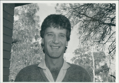
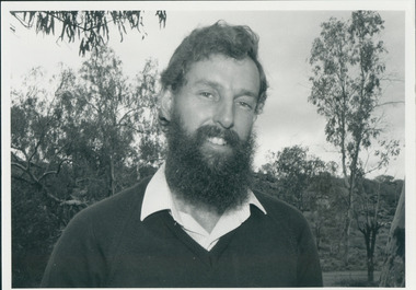 Uniting Church Archives - Synod of Victoria
Photograph, St Philip's College Alice Springs - Principal Chris Tudor & Deputy Principal Chris Eldridge, 09/1986
... the original plan to turn St Philip’s College into a fully fledged... that the time was right to complete the original plan to turn St ...In 1945 the Reverend Harry Griffiths, who worked for the Methodist Inland Mission in Alice Springs, saw the need for a boarding facility for children of families living in remote areas in Central Australia who needed access to schools. He and his wife established Griffiths House, on a site in the town centre, and for many years it became home for students from all over the Outback, including many young Aboriginal people. In the late 1950's the Rev Fred McKay, successor to the Rev John Flynn as Superintendent of the Australian Inland Mission, lobbied the United Church in the Northern Territory to build and expand on this important start. Together the Presbyterian, Methodist and Congregational churches embarked on a missionary venture to develop St Philip's College - a new, larger residential hostel which would one day become a full boarding school. An ideal site - 22 acres of bush at the junction of the Charles and Todd Rivers and backing on to the Telegraph Station National Park - was secured and after six years of planning, construction began in 1964. Fred McKay led the legendary work parties comprised of volunteers from all over Australia who travelled to Alice Springs, paying their own way and volunteering their expertise, time and labour, to turn a dream into a reality. This fantastic tradition continues today, with work parties arriving each mid-year holiday. On 13 February 1965 the first boarders moved in to St Philip's College. For the first 24 years, therefore, St Philip's College operated as a residential hostel only. The College’s ninth Headmaster, Mr Christopher Tudor, arrived in 1986. He and the Council Chairman, Mrs Jan Heaslip, judged that the time was right to complete the original plan to turn St Philip’s College into a fully fledged independent boarding/day school, serving not only “bush” families, but also the growing population of Alice Springs. The then College Council embraced the idea and three years of frantic, determined preparation and planning commenced, culminating in an extensive $2 million building program in 1988. To this day there continues to be further development with the new landscaping underway near The Minnamurra Hall, Reception and Rivergum Cafe, plus the recent completion of the Science & Food Technology building and the new Rivergum Cafe.Head & Shoulders of Chris Tudor.st. philip's college, tudor, chris, eldridge, chris -
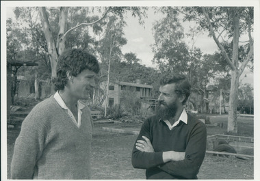 Uniting Church Archives - Synod of Victoria
Photograph, St Philip's College Alice Springs - Principal Chris Tudor & Deputy Principal Chris Eldridge, 09/1986
... the original plan to turn St Philip’s College into a fully fledged... that the time was right to complete the original plan to turn St ...In 1945 the Reverend Harry Griffiths, who worked for the Methodist Inland Mission in Alice Springs, saw the need for a boarding facility for children of families living in remote areas in Central Australia who needed access to schools. He and his wife established Griffiths House, on a site in the town centre, and for many years it became home for students from all over the Outback, including many young Aboriginal people. In the late 1950's the Rev Fred McKay, successor to the Rev John Flynn as Superintendent of the Australian Inland Mission, lobbied the United Church in the Northern Territory to build and expand on this important start. Together the Presbyterian, Methodist and Congregational churches embarked on a missionary venture to develop St Philip's College - a new, larger residential hostel which would one day become a full boarding school. An ideal site - 22 acres of bush at the junction of the Charles and Todd Rivers and backing on to the Telegraph Station National Park - was secured and after six years of planning, construction began in 1964. Fred McKay led the legendary work parties comprised of volunteers from all over Australia who travelled to Alice Springs, paying their own way and volunteering their expertise, time and labour, to turn a dream into a reality. This fantastic tradition continues today, with work parties arriving each mid-year holiday. On 13 February 1965 the first boarders moved in to St Philip's College. For the first 24 years, therefore, St Philip's College operated as a residential hostel only. The College’s ninth Headmaster, Mr Christopher Tudor, arrived in 1986. He and the Council Chairman, Mrs Jan Heaslip, judged that the time was right to complete the original plan to turn St Philip’s College into a fully fledged independent boarding/day school, serving not only “bush” families, but also the growing population of Alice Springs. The then College Council embraced the idea and three years of frantic, determined preparation and planning commenced, culminating in an extensive $2 million building program in 1988. To this day there continues to be further development with the new landscaping underway near The Minnamurra Hall, Reception and Rivergum Cafe, plus the recent completion of the Science & Food Technology building and the new Rivergum Cafe.Tudor and Eldridge in conversation with the College in the background.st. philip's college, tudor, chris, eldridge, chris