Showing 5192 items
matching palm-avenue
-
 Kew Historical Society Inc
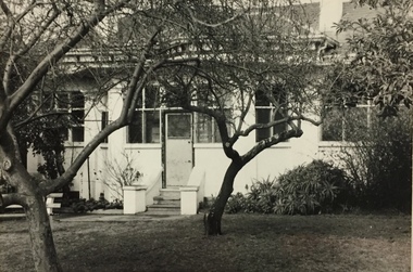
Photograph, Glendonald School for the Deaf, Marshall Avenue, 1955-1965
Glendonald School for Deaf Children was run by the Victorian Education Department. It provided education and some residential services for deaf children. The school was situated in Marshall Avenue, Kew and operated from 1951–91. Deaf children whose families lived too far to travel daily were housed in a grand Victorian mansion in Belmont Avenue, Kew, the John Cannon Hostel. The school and hostel also accommodated a small number of wards of the state. (Source: Glendonald School for Deaf Children 1951–91)Glendonald was a significant mansion in Kew (now demolished) built for the industrialist and manufacturer Donald Leslie in 1886. The school was purchased by the Victorian Department of Education on 29 November 1950 for the sum of 16,500 pounds.Rear view (sic) of Glendonald, Marshall Avenue (Kew).Reverse: "The old school for the deaf at 17 Marshall Ave for children from the age of six years to ten years old, then they would go to 25 Marshall Ave to finish their schooling leaving age 16 years old."glendonald - marshall avenue - kew (vic), education - deaf children - victoria -
 Greensborough Historical Society
Photograph - Digital image, Marilyn Smith, House, Poulter Avenue Greensborough 2016, 11/08/2016
Two photographs of the 4 Poulter Avenue Greensborough. Front and rear aspects.Digital copy of colour photograph.poulter avenue greensborough -
 Greensborough Historical Society
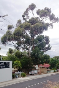
Photograph - Digital image, Marilyn Smith, Tree, Poulter Avenue and Main Street, 20/10/2016
This established tree in Poulter Avenue Greensborough is at risk from development of the surrounding properties.Established trees such as this have been removed as the area is developed.Digital copy of 3 colour photographspoulter avenue greensborough -
 Whitehorse Historical Society Inc.
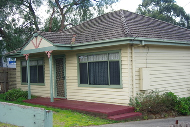
Document, 8 Hazelmere Avenue, Mitcham, c1975
Plan and specifications for property extensions and alterationsPlan and specifications for property extensions and alterations to 8 Hazelmere Avenue, Mitcham for Mr O.M.J. Grant.Plan and specifications for property extensions and alterations grant, max, hazelmere avenue, mitcham, no 8 -
 Eltham District Historical Society Inc
Photograph, Gayle Blackwood, Mudbrick home, 23 Stanley Avenue, Eltham, 2002, 2002
Home and garden at 23 Stanley Avenue; Charles Hanlin, builder; Landscape by Gordon Ford.11 colour prints 10 x 15 cmhouses, mudbrick, gayle blackwood collection, charles hanlin, gordon ford, stanley avenue, eltham -
Whitehorse Historical Society Inc.
Legal record - Correspondence, 8 Hazelmere Avenue, Mitcham, 1950 - 1953
Correspondence and accountsCorrespondence and accounts, relating to the construction of a house at 8 Hazelmere Avenue, Mitcham for Max Grant. J. Chugg, Builder.Correspondence and accountschugg, max, hazelmere avenue, mitcham, no 8 -
 Victorian Interpretive Projects Inc.
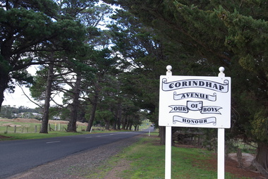
Photograph - Colour, Corindhap Avenue of Honour, 2015, 23/08/2015
"The Corindhap Avenue of Honour, located on Colac-Ballarat Road, was planted to commemorate those who served in the First World War. The avenue was planted on the 15th September 1917 as a mark of admiration for the men of Corindhap who had left to fight in the Great War." (Ballarat Courier, 19th September 1917) A number of colour photographs showing trees from the Corindhap Avenue of Honour. The trees are not in good condition, and one has fallen over. corindhap, corindhap avenue of honour, avenue of honour, world war one -
 Glen Eira Historical Society
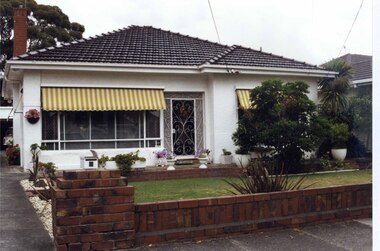
Photograph, Beauville Avenue, 6, Murrumbeena, 2001
Originally labelled "Beauville Estate, Established 1936, Still Thriving 65 years on, 10th March 2001", the Beauville Estate Album contains colour photographs of houses in the Estate. They were taken around the time of the Beauville Estate’s 65th Heritage Celebration held on 10/03/2001 and donated to the Caulfield Historical Society shortly afterwards. Photographer Bev Baxter. City of Glen Eira’s Heritage Management Plan Vol 2 p79 (this is p84 of the pdf version) – HO12 Beauville Estate and environs, Murrumbeena: The Beauville Historic Area is important at the State level as the first large housing estate undertaken by the AV Jennings Construction Co, later Jennings Group Limited, Victoria’s largest home builder. It is important also as a very early estate development incorporating a range of features other than houses and including made roads, shops and recreation facilities. In this respect it was the forerunner of the comprehensively planned housing estate of the post war era. The estate is distinguished by its aesthetic values, as is the earlier and comparable Hillcrest Estate, which are formed by a combination of restrained diversity in house styles, with the exception of no. 30 in the emerging International style, and by a landscaped garden environment. Colour photograph of a white rendered house with striped yellow and white window awnings. Other features include a tiled roof, a cast iron work front porch door, garden urns in front of the house and a low unpainted brick fence in the foreground with a car in its garage down the drive to the left. The garden beds are also supported by walls of the same unpainted bricks with plants including a palm and succulents.murrumbeena, houses, beauville avenue, architectural styles, 1930's, inter war style, a.v. jennings, av jennings, jennings, brick houses, beauville estate, porches, sir albert victor jennings, a v jennings construction co, beauville estate heritage area, glen eira city council, architectural features, jennings group limited, land subdivision, gardens, beauville historic area, cast iron work gates, striped awnings, outdoor ornaments, brick fences, drives, cars, garages (private), palm trees, brick chimneys -
 Surrey Hills Historical Society Collection
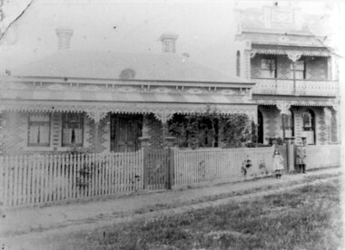
Photograph, 'Maitland', 1 Bedford Avenue, Surrey Hills, c 1900, 1900
Maitland' was built in 1889 for Thomas Zeplin, who was a Professor of Music. He owned all the land bound by Union Road, Wilson and Montrose Streets and the railway line. 1 Bedford Avenue stayed in family ownership until purchased by Camberwell Council in 1986, initially for a car park. However it was renovated to become part of Surrey Hills Neighbourhood Centre. It was opened on 23 November 1990. No 3 Bedford Avenue was built for Thomas Zeplin's daughter and named 'Mervyl' or 'Merryl'. Mrs Brodecky (donor) was the great-granddaughter of Thomas Zeplin. The 2 girls are granddaughters of Thomas Zeplin. Electoral roll information: 1972 & 1977: Albert Vojteck Brodecky, manager, 1 Bedford Avenue. 1977: Ray Nanette Brodecky. There are 2 copies. Thomas had this built for his son and family. The house was occupied by his family, though sometimes rented out. His great-grand-daughter Mrs. A. Brodecky sold to the Camberwell Council in 1986. This was the only surviving photo in the family after the fire. Courtesy: Mrs. A. BrodeckyBlack and white photo of 2 houses taken from the street front. On the LHS is a Victorian double-fronted single-storey villa of Hawthorn brick construction, with wrought iron lacework to the veranda, slate roof and picket fence, with an established garden. Next door at No 3 is a double-storey Victorian terrace with a similar fence and building materials. There are 2 young girls standing in front between the properties.maitland, bedford avenue, 1900, surrey hills neighbourhood centre, victorian style, mervyl, merryl, mr thomas zeplin, mrs nanette brodecky, mr albert vojteck brodecky -
 Bacchus Marsh & District Historical Society
Photograph, Osage Orange Avenue Taverner Street Bacchus Marsh
A.C. (Arthur Charles) Simon a pioneer orchardist in the Bacchus Marsh district planted this avenue of Osage orange trees in about 1883, creating an imposing entrance to his property from Taverner Street. Simon also believed that the trees on his orchard property would provide a protective shelter for his other plants. Osage orange trees (Maclura pomifera) are a small deciduous tree or large shrub, native to the south-central United States. It usually grows to about 8 to 15 metres high. The distinctive fruit, a multiple fruit that resembles an immature orange, is roughly spherical in shape, about 8 to 15 centimetres in diameter, and turns bright yellow-green in the autumn. A. C. Simon is believed to have imported the Osage orange seeds from America around the 1860s and later used them to plant the trees depicted in this image. The date of this image is not certain but it probably shows the trees around the 1900s or 1910s. The avenue of trees was known for many years in Bacchus Mars as 'Simons Avenue', and were featured in a Rose series postcard dating from around 1900-1920. The remnants of this avenue or grove of trees can be seen on some of the properties on the north side of Taverner Street Bacchus Marsh and along the Werribee River west of the FIsken Street bridge.The Bacchus Marsh Heritage Study of 1995 described the Osage Orange Tree avenue as being of regional historical significance as a landscaping practice, pioneering of its type, It was also described as of local significance as a well-known landmark due to it be being represented on widely distributed post cards which depicted scenes of Bacchus Marsh in the early part of the twentieth century. This early photographic image is evidence of this social and cultural significance.A black and white photograph print mounted on mounting board showing an avenue of Osage orange trees. trees, osage orange trees, simon family bacchus marsh, arthur charles simon 1833-1924, orchardists -
 Whitehorse Historical Society Inc.
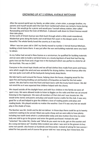
Document, Growing Up At 1 Vernal Avenue, 1947 - 1962
Childhood memories of Jenny Brash & her neighbours. She grew up at 1 Vernal Avenue, Mitcham and later Glenburnie Road.Childhood memories of Jenny Brash & her neighbours as she grew up at 1 Vernal Avenue, Mitcham and later Glenburnie Road.Childhood memories of Jenny Brash & her neighbours. She grew up at 1 Vernal Avenue, Mitcham and later Glenburnie Road.vernal avenue mitcham no1, brash jenny, orient avenue mitcham, wills jack, wills victor, glenburnie road mitcham no25 -
Whitehorse Historical Society Inc.
Document, 8 Hazelmere Avenue Mitcham, c1953
Plan and elevation for proposed brick veneer residencePlan and elevation for proposed brick veneer residence, 8 Hazelmere Avenue, Mitcham for O.M.T. Grant Esq. J. Chugg, 2 Morey Street, Burwood, Builder.Plan and elevation for proposed brick veneer residencegrant, max, hazelmere avenue, mitcham, no 8, j.r.., chugg -
 Emerald Museum & Nobelius Heritage Park
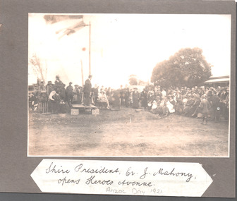
Mounted Photograph, 25/4/1921
The object is historically and socially significant as it shows the opening of Heroes Avenue (Avenue of Honor) three years after the end of Word War I. The trees planted in the Avenue came from the Nobelius Nursery.Photograph mounted on card of the opening of Heroes Avenue, Emerald on ANZAC Day 1921. Showing Shire President Cr J Mahony opening the AvenueShire President Cr J Mahony, opens Heroes Avenue. ANZAC Day 1921anzac, heroes avenue, avenue of honor, emerald -
 Phillip Island and District Historical Society Inc.
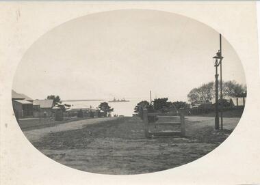
Photograph, Thompson Avenue, Cowes Phillip Island, 1920
This is from Jessie Smith's collection presented by Stan McFee. The vessel is HMS Australia. Avenue shows young Cypress trees planted in 1912 approx.Black & White Photograph of Thompson Avenue, looking north across Western Port Bay. Silhouetted ship in middle. Young Cypress in middle with lamp-post and pole at extreme right.HMS Australia 1920 Coweslocal history, photographs, mains street - streetscape - cowes, phillip island, black & white photograph, jessie smith, main street cowes 1920, stan mcfee -
 Ringwood and District Historical Society
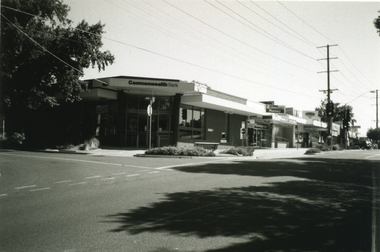
Photograph-B&W, Joan Walker, East Ringwood 2000- Railway Avenue cnr Stanley Avenue (Commonwealth Bank on corner) opposite railway station, 2000
East Ringwood 2000- Railway Avenue cnr Stanley Avenue (Commonwealth Bank on corner) opposite railway station- B&W Photo from Album 6501 -
 Emerald Museum & Nobelius Heritage Park
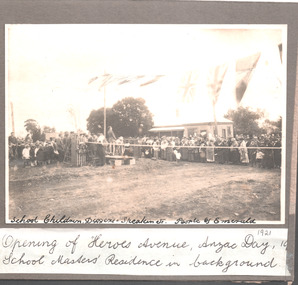
Mounted Photograph, 25/4/1921
The object is historically and socially significant as it shows the opening of Heroes Avenue (Avenue of Honor) three years after the end of Word War I. The trees planted in the Avenue came from the Nobelius Nursery.Photograph mounted on card of the opening of Heroes Avenue, Emerald on ANZAC Day 1921. Showing opening of Heroes AvenueSchool Children, Diggers + Speakers ect. People of Emerald. Opening of Heroes Avenue, ANZAC Day 1921, School Masters' Residence in backgroundanzac, heroes avenue, avenue of honor, emerald -
 Ringwood and District Historical Society
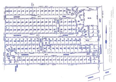
Map, Subdivision Plan - Rosebank Avenue area, North Ringwood, Vic. - circa 1960s
Single page plan printed on green background showing allotments included in un-named subdivision layout surrounding "Rosebank" property, Warrandyte Road, Ringwood North. Subdivision includes Through Road, Rosebank Avenue, Macey Grove, Goldsmith Avenue, Dillon Grove, Lockhart Road, and Warrandyte Road.Typewritten notation against "Rosebank" property - "Mrs Godbehear, Snr.". "Goldsmith is maiden name of Mrs. Godbehear, Senior. (1960). Lockhart is town where their property "Rosebank" is situated. (In Riverina)". Additional Rosebank Avenue allotments blueprint clipping on light cardboard backing incldes handwritten title reference LP57659. -
 Glen Eira Historical Society
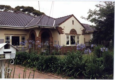
Photograph, Beauville Avenue, 10, Murrumbeena, 2001
Originally labelled "Beauville Estate, Established 1936, Still Thriving 65 years on, 10th March 2001", the Beauville Estate Album contains colour photographs of houses in the Estate. They were taken around the time of the Beauville Estate’s 65th Heritage Celebration held on 10/03/2001 and donated to the Caulfield Historical Society shortly afterwards. Photographer Bev Baxter. From Glen Eira’s Heritage Management Plan by Andrew Ward (1996) Vol 2 p63: The inclusion of shops in Murrumbeena Road and a common parkland developed at the rear of the properties were complemented by the construction of a gas display home at No. 10 Beauville Avenue.City of Glen Eira’s Heritage Management Plan Vol 2 p79 (this is p84 of the pdf version) – HO12 Beauville Estate and environs, Murrumbeena: The Beauville Historic Area is important at the State level as the first large housing estate undertaken by the AV Jennings Construction Co, later Jennings Group Limited, Victoria’s largest home builder. It is important also as a very early estate development incorporating a range of features other than houses and including made roads, shops and recreation facilities. In this respect it was the forerunner of the comprehensively planned housing estate of the post war era. The estate is distinguished by its aesthetic values, as is the earlier and comparable Hillcrest Estate, which are formed by a combination of restrained diversity in house styles, with the exception of no. 30 in the emerging International style, and by a landscaped garden environment. Colour photograph of cream rendered house with decorative unpainted brown brick features. Other features include a porch with two decorative open arches, tiled roof, 2 sets of matching double sashed windows with large square pane within each set, agapanthus lining the brick paved driveway and a cast iron work metal letterbox with number "10" on it. murrumbeena, houses, beauville avenue, architectural styles, 1930's, inter war style, a.v. jennings, av jennings, jennings, brick houses, beauville estate, porches, arches, sir albert victor jennings, a v jennings construction co, beauville estate heritage area, glen eira city council, architectural features, jennings group limited, land subdivision, gardens, beauville historic area, brick features, sash windows, paved drives, cast iron work, letter boxes, gas display houses -
Ringwood and District Historical Society
Report, Ringwood Bypass and Suda-Larissa Avenue pedestrian crossing reports. 1992, 14-Jul-92
Brief notes and a locality map issued to local householders about a meeting to discuss the Suda-Larissa Avenue pedestrian crossing.Brief notes and a locality map issued to local householders about a meeting to discuss the Suda-Larissa Avenue pedestrian crossing. Report comprising three white A4 pages: two with typed notes and one of Ringwood Bypass notes. +Additional Keywords: Adams, Chris -
 Lakes Entrance Historical Society
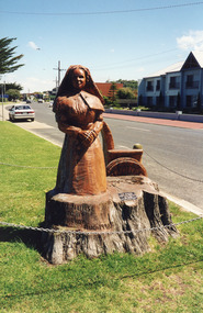
Photograph - WW1 Memorial avenue cypresses tree carvings by John Brady, 1999
most westerly chain saw carving made from trunk of WW1 Memorial avenue cypresses. On lawn verge, south of Princes Highway, opposite Bellevue, Lakes Entrance Victoria Carved by chainsaw artist John Brady August 1998.Colour photograph of the most westerly chain saw carving made from trunk of WW1 Memorial avenue cypresses. On lawn verge, south of Princes Highway, opposite Bellevue, Lakes Entrance Victoriaworld war 1914-1918, memorials -
 Whitehorse Historical Society Inc.
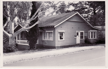
Photograph, The Avenue Neighbourhood Centre
Black and white photograph of The Avenue Neighbourhood House established in the former Manse of the Avenue Uniting Church on the corner of Blackburn Road and the Avenue. 1980s Blackburnthe avenue neighbourhood house, the avenue uniting church, blackburn, community houses, blackburn road, neighbourhood houses -
 Kew Historical Society Inc
Photograph - Photographs, Former Baptist Church, Woodlands Avenue, Kew East, 2018, 2018
The former Baptist Church, at 8-12 Woodlands Avenue, Kew East, was nominated by the Society for protection as part of the Kew East Heritage Gap Study. W D Vaughan in his 'Kew's Civic History' (1960 writes that: "With the development of East Kew, local Baptists considered the establishment of a church was necessary. A block of land was purchased in Woodlands Avenue and the foundation stone of a new church was laid on August 8, 1931. A fine Sunday school has since been erected, and special emphasis has been given to providing activities for the young people of the church"Three colour photographs of the former Baptist Church in Woodlands Avenue, Kew East. The photographs are of the front and side of the clinker brick building. One of the photographs shows the foundation stone, laid by AH Lewis Esq, 8 August 1931.churches - kew (vic), baptist church - woodlands avenue - kew (vic) -
 Glen Eira Historical Society
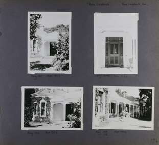
Album - Album page, Rose Craddock, Rose Craddock Avenue, Circa 1972
This photograph is part of the Caulfield Historical Album 1972. This album was created in approximately 1972 as part of a project by the Caulfield Historical Society to assist in identifying buildings worthy of preservation. The album is related to a Survey the Caulfield Historical Society developed in collaboration with the National Trust of Australia (Victoria) and Caulfield City Council to identify historic buildings within the City of Caulfield that warranted the protection of a National Trust Classification. Principal photographer thought to be Trevor Hart, member of Caulfield Historical Society. Most photographs were taken between 1966-1972 with a small number of photographs being older and from unknown sources. All photographs are black and white except where stated, with 386 photographs over 198 pages. From Victorian Heritage Database citation for H0589 Rosecraddock 4-10 Craddock Avenue and 2-8 Keverell CAULFIELD NORTH https://vhd.heritagecouncil.vic.gov.au/places/35279 as at (30/10/2020) "Rosecraddock" is regionally important as a surviving large villa from the early Victorian (1850's) period, offering insight into the lifestyles of the privileged in Caulfield at that time. Its importance is enhanced through its long association with the Langdon family and, in particular, Henry Joseph Langdon, founder of H.J. Langdon and Company, China merchants. Victorian Heritage Database HO16 Rosecraddock, 2-8 Keverell Road & 4-10 Craddock Avenue Caulfield North https://vhd.heritagecouncil.vic.gov.au/places/35279 (as of 17/02/2021) A single storeyed stuccoed villa with west facing facade consisting of a parapeted and recessed central section with hipped slate roof and timber posted verandah with cast iron lace. Projecting pavilions have bayed windows and a secondary wing runs north with angled corners and prominent chimney stack. The front entrance is situated at the north end of the central section and is given emphasis by a small hip roof and false pediment to the verandah. Outbuildings include the timber stables with characteristic hay loft gablet and fretted barges to the south-east. Rear additions in brick and timber are of an early date and utilitarian in character. Also see https://vhd.heritagecouncil.vic.gov.au/places/277 for Significance Statement for the H0589 Victorian Heritage Register listing.Page 174 of Photograph Album with four photographs of Rose Craddock.Handwritten: "Rose Craddock" Rose Craddock Ave. top right] / Neg 197 Nov 1972 [under top left photo] / Neg 209 Nov 1972 [under top right photo] / Neg 196 Nov 1972 [under bottom left photo] / Neg 195 198 Nov 1972 [under bottom right photo] / 174 [bottom right]trevor hart, chimneys, porch, rose craddock, rosecraddock, ringwood, 1850's, henry joseph langdon, h.j. langdon, h.j. langdon and company, china merchants, rosecraddock place, slate roof, return verandah, decorative brackets, keverell road, caulfield north, early victorian style, protruding bay windows, cast iron work, rendered walls, entrances, mansions, craddock avenue -
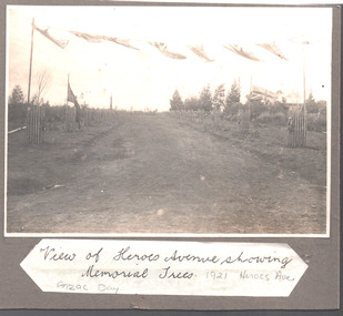 Emerald Museum & Nobelius Heritage Park
Mounted Photograph, 25/4/1921
The object is historically and socially significant as it shows the opening of Heroes Avenue (Avenue of Honor) three years after the end of Word War I. The trees planted in the Avenue came from the Nobelius Nursery.Photograph mounted on card of the opening of Heroes Avenue, Emerald on ANZAC Day 1921. Showing The newly planted memorial trees..View of Heroes Avenue showing Memorial Trees. ANZAC Day 1921 Heroes Aveanzac, heroes avenue, avenue of honor, emerald -
 Mt Dandenong & District Historical Society Inc.
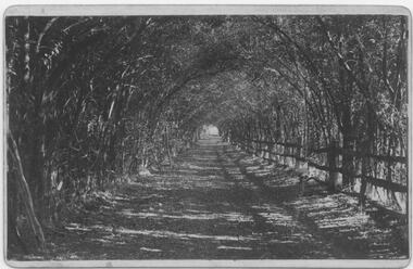
Photograph, Clematis Avenue, Sassafras, c1913
This set of 8 photographs was produced by the Rose Stenograph Co. c1913 to be included in photograph albums. The show tourist scenes of Sassafras and surrounds. The photographs were donated by a family in Western Australia whose parents lived in Sassafras c1918.Small b & w photograph from a series of 8 showing scenes from Sassafras produced by the Rose Stenograph Co. c1913.On reverse - Clematis Avenue, Sassafras.sassafras, clematis avenue -
Friends of Ballarat Botanical Gardens History Group
Work on paper - Ballarat Botanical Gardens by Lake Wendouree, The Fernery (Palm House), C 2002
The article was produced by the Ballarat City Council entitled "The Fernery". It deals with developments, purpose and plans for the Fernery from 1955.This page testifies to the importance Ballarat City Council attached to the Fernery around the turn of the century and the plan to make it "the next landmark project", after the Australian Ex-POW Monument was finished in 2004.One page of 6 paragraphs in font 12.Logo, central top of page, "Ballarat Botanical Gardens by Lake Wendouree" in black and white.john garner, doctor, john garner collection, ballarat botanical gardens, the fernery, friends of ballarat botanical gardens, ballarat botanical gardens masterplan and management strategy, ballarat city council, gardens, ballarat -
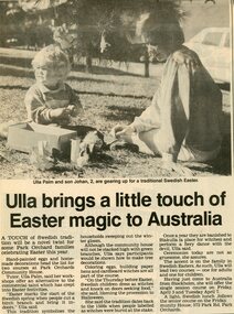 Park Orchards Community House
Newspaper, Swedish Easter classes at Park Orchards Community House with tutor Ella Palm. Doncaster and Templestowe News, 24 March 1987
-
 Stawell Historical Society Inc
Photograph - Oban Stawell RSL, Stawell RSL with Palm Tree
Stawell R.S.L. Formerly "Oban" Private residence of a Mine Owner.Former mine owners residenceB/W photo Stawell R.S.L. after balconies removed taken from Scallon St. Sows front door and steps. Lattice fence to back yard. removed white with black lettersstawell houses -
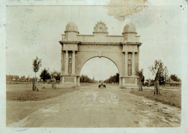 Federation University Historical Collection
Photograph - Photograph - Black and White, Ballarat Avenue of Honour
Two digital copies of early photographs of the Ballarat Avenue of Honour showing small trees in the Avenue of Honour, and a muddy dirt road. ballarat avenue of honour, ballarat arch of victory, world war one, sturt street -
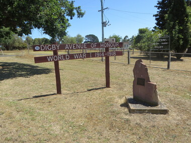 Ballarat Heritage Services
Photograph - Colour, Clare Gervasoni, Digby Avenue of Honour, Victoria, 22/12/2015
Colour photograph of the Dignby Avenue of Honour.digby, digby avenue of honour, world war one