Showing 3055 items matching "public building"
-
 City of Ballarat Libraries
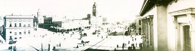
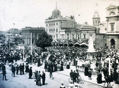
Photograph - Card Box Photographs, Panorama view of Sturt Street, Ballarat circa 1903
... Streetscape Building Public Commerical Panorama view of Sturt Street ...Panoramic view of Sturt Street looking south west taken from the GPO Building.panorama, sturt street, streetscape, building, public, commerical -
 City of Ballarat Libraries
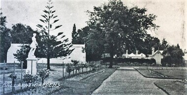
Postcard - Card Box Photographs, Keel Glasshouse and Caretaker's House, Ballarat Botanic Gardens 1929
... Gardens Gardens Building Public Statues Keel Glasshouse ...This area is now the Prime Minister's Avenue.keep glasshouse, caretaker's house, ballarat botanic gardens, gardens, building, public, statues -
 City of Ballarat Libraries
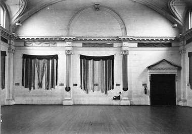
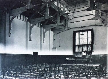
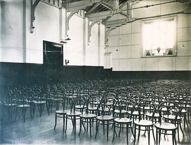
Photograph - Card Box Photographs, Ballarat Town Hall interior circa 1950
... Building Public Ballarat Town Hall interior circa 1950 Photograph ...Upstairs Back Hall.ballarat town hall, building, public -
 City of Ballarat Libraries
Photograph - Card Box Photographs, East Ballarat Town Hall & Court House circa 1890s
... Court House Gardens Building Public East Ballarat Town Hall ...east ballarat town hall, east ballarat court house, gardens, building, public -
 City of Ballarat Libraries
Photograph - Card Box Photographs, Interior of the Ballarat Town & City Mission Hall circa 1930
... . Ballarat Town & City Mission Building Public Interior ...The hall was located on Main Road.ballarat town & city mission, building, public -
 City of Ballarat Libraries
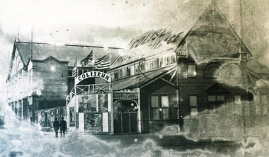
Photograph - Card Box Photographs, Coliseum Picture Palace circa 1920
... Grenville Street Building Public Coliseum Picture Palace circa 1920 ...The Coliseum was burnt down 26th March 1936. It stood on Grenville Street.coliseum picture palace, grenville street, building, public -
 City of Ballarat Libraries
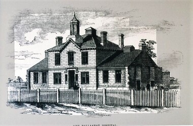
Postcard - Card Box Photographs, The original Ballarat Hospital 1858
... . Ballarat Hospital Building Public The original Ballarat Hospital ...Sketch of early miner's hospital in Lydiard Street North before being rebuilt in Drummond Street North.ballarat hospital, building, public -
 City of Ballarat Libraries
Photograph - Card Box Photographs, Vale's Corner, Ballarat circa 1880
... is now. Vale's Corner Building Public Persons Commerical Vale's ...The building was located on the south east corner of Sturt and Grenville Streets. Possibly, where Priceline is now. vale's corner, building, public, persons, commerical -
 City of Ballarat Libraries
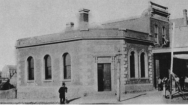
Photograph - Card Box Photographs, East Ballarat Fire Station circa 1900
... Ballarat East goldfields East Ballarat Fire Station Building Public ...east ballarat fire station, building, public -
 City of Ballarat Libraries
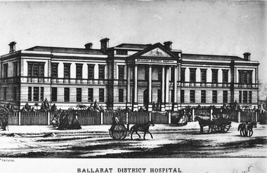
Postcard - Card Box Photographs, Ballarat District Hospital circa 1868
... . Ballarat District Hospital Drummond Street North Building Public ...This could possibly be an architect's sketch. The building was located on Drummond Street North.ballarat district hospital, drummond street north, building, public -
 City of Ballarat Libraries
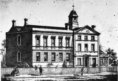
Photograph - Card Box Photographs, Ballarat District Hospital circa 1860
... on the Drummond Street North site. Ballarat District Hospital Building ...Possibly the 2nd hospital built on the Drummond Street North site.ballarat district hospital, building, public, drummond street north -
 City of Ballarat Libraries
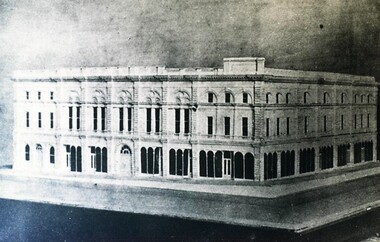
Photograph - Card Box Photographs, Proposed design for the 3rd Ballarat Town Hall circa 1868
... Ballarat East goldfields Ballarat Town Hall Building Public ...ballarat town hall, building, public -
 City of Ballarat Libraries
Photograph - Card Box Photographs, Proposed design for the 3rd Ballarat Town Hall circa 1868
... Ballarat East goldfields Ballarat Town Hall Building Public ...ballarat town hall, building, public -
 City of Ballarat Libraries
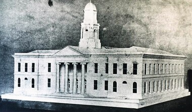
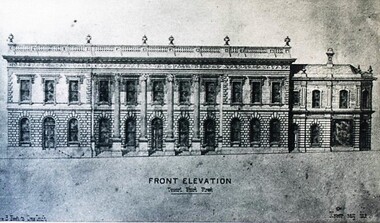
Photograph - Card Box Photographs, Winning design for 3rd Ballarat Town Hall circa 1868
... Town Hall Building Public Winning design for 3rd Ballarat Town ...Design submitted by H.R. Caselli.ballarat town hall, building, public -
 City of Ballarat Libraries
Photograph - Card Box Photographs, Interior of the Ballarat Town & City Mission Hall circa 1940
... Ballarat East goldfields Ballarat Town & City Mission Building ...ballarat town & city mission, building, public -
 City of Ballarat Libraries
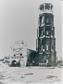
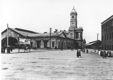
Photograph - Card Box Photographs, Ballarat Railway Station circa 1920
... Railway Station Building Public Persons Ballarat Railway Station ...Sign advertising Picnic Excursion Trains to Stawell, Camperdown, Maryborough, Murtoa and Dimboola.ballarat railway station, building, public, persons -
 City of Ballarat Libraries
Photograph - Card Box Photographs, Unveiling of the Boer War Statue, Ballarat 1906
... Building Public Commerical Unveiling of the Boer War Statue ...People stand around the Queen Victoria statue watching the unveiling of the Boer War statue.boer war statue, queen victoria statue, sturt street, persons, monument, building, public, commerical -
 City of Ballarat Libraries
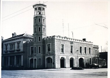
Photograph - Card Box Photographs, Ballarat City Fire Station 1969
... on Sturt Street. Ballarat City Fire Station Sturt Street Building ...Includes fireman's house adjoining on Sturt Street.ballarat city fire station, sturt street, building, public -
 City of Ballarat Libraries
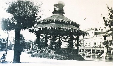
Photograph - Card Box Photographs, Alexandra Bandstand, Ballarat 1938
... Bandstand Sturt Street Ballarat Centenary Celebrations Building ...Located in Sturt Street, the Bandstand was decorated for the Ballarat Centenary Celebrations.alexandra bandstand, sturt street, ballarat centenary celebrations, building, public -
 City of Ballarat Libraries
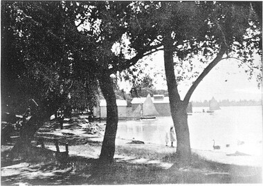
Photograph - Card Box Photographs, Boat Sheds, Lake Wendouree
... Ballarat East goldfields Boat Sheds Lake Wendouree Yacht Building ...boat sheds, lake wendouree, yacht, building, public -
 University of Melbourne, Burnley Campus Archives
Photograph, Pruning Day 1980, 1980
... pruning fruit trees burnley public day administration ...pruning, fruit trees, burnley, public day, administration building, agnotes, blossom tree, pruning demonstrations, orchard, field station -
 Flagstaff Hill Maritime Museum and Village
Document - Framed Poster, Borough of Warrnambool, Victoria, Australia, after 30/06/1875
... and facilities, public buildings and institutions, imports and exports... location, public buildings and institutions, harbor facilities..., Harbour and facilities, public buildings and institutions, imports ...This document, also referred to as a word picture or Tablet, is framed in glass and timber with gilt trim, is handwritten with colour highlights. The penned letters rest on ruled guide lines, decorated where the lines intersect. The writing gives a description of the state of Borough of Warrnambool around 1875; its location, the area it covers, its population, Harbour and facilities, public buildings and institutions, imports and exports, financial worth, number of houses, connection with other areas of the Colony. A possible reason and origin for the document is found in an article ‘Link with US Exhibition’ from the Warrnambool Standard of December 19, 1981, written by local historian Bruce Morris. The writer mentions that the Warrnambool Borough Council met on 15th June 1875 and recorded a letter from G.C. Levey , secretary to the Melbourne group of commissioners representing the Colony, and Victoria in particular, for the Philadelphia Centennial Exhibition of 1876. The letter asks Council to provide “statistics as to the population, social condition and commercial and industrial state of the district in and around Warrnambool.” A sub committee was formed for the project. The Mayor, Cr. Thomas King, wrote and signed a Report, presented to the council on July 14, 1875, in which “The Committee … begs to recommend that a Tablet be prepared setting for the particulars respecting the following matters relating to the Borough”. The matters included area, population, annual income, churches, schools, other public buildings, societies and companies, general description of houses erected, and returns of exports and imports for 1874. The minutes note that the Report was adopted. The article above also notes the opinion of Warrnambool printers who have examined the document; it is almost certainly to be an old lithograph, which means there could be several copies. It is possible that there may be a copy in Melbourne and another in Philadelphia. It is interesting to note that (1) the quoted location co-ordinates are for an “Unnamed Road, Packsaddle NSW 2880, Australia”, and that the DMS co-ordinates for Warrnambool’s Council Offices differ, being 38.23.9.12 South, 142.28.52.887. (2) the date for “Exports and Imports for the Year Ending 30th June 1875” is different to the period mentioned by Cr. King in the sub committee’s Report of recommendation “returns of exports and imports for 1874”. The information required to have the figures for the end of June 1875 would need to have been compiled very quickly for the Tablet to be ready for the opening of the Philadelphia Exhibition on 10 May 1876. The document/certificate shows the following – - - - - - - - - - - - - - - -- - - - - - - - - - - - - - -- - - - - - - - - - - - - - -- - - - - - - - - - - - - - - “Victoria Australia, Borough of Warrnambool. Latitude, 30.24.50 South, Longitude 142.32 East The Principal Port in the Western District of the Colony and the Centre of its Choicest Agricultural Lands. Established a Municipality in 1855, and Created a Borough 1863. Population in 1875 4,500. Warrnambool is the nearest Port to Melbourne on the Western Seaboard, being about 160 miles distant. Coaches run to and from the Metropolis daily, in connexion [connection] with the Railway of Geelong and Steamers belonging to Local Companies sail between Melbourne, Warrnambool, Belfast [renamed Port Fairy], and Portland several times weekly. The Harbour is known as Lady Bay, and is partially protected by a reef of rocks stretching from the mouth of the Hopkins River. The formation of a Breakwater has been decided upon by the Government, to extend 600 yards, at an estimated cost of £100,000. There are two substantial Jetties, one of 800 and the other of 600 feet in length. The former is connected with the Town by means of a Tramroad, along which Goods, inwards & outwards, are conveyed, & the latter has been constructed solely for the purpose of facilitating the transit of material for the formation of the Breakwater. In addition to the trade of the Borough and District, the principal Townships up country receive their supplies from Melbourne and ship their exports through Warrnambool. Potatoes form the staple produce of the district, and the richness of the soil can be estimated by the fact that the Government Statistics for 1875 give as the average yield a return of Seven Tons to the acre. Several thousand acres between Warrnambool and Tower Hill are now being laid down in Potatoes by Tenants who have leased the lands at rates up to £5 per acre for the season 1875-6. Wool, Tallow, hides &c are also largely exported, while the shipments of all descriptions of Farm Produce are annually increasing. Area of Borough, 3362 Acres. Net Annual Value £27,000. Annual Revenue £5,500. Number of Houses in Borough 800. Public Buildings and Institutions Churches. Church of England, Roman Catholic, Presbyterian, Wesleyan, Congregational and Baptist. Schools. Three State Schools, average attendance nearly 1000. New Building in course of erection. Several private establishments. Banks. Bank of Australasia, Bank of Victoria, National Bank, Colonial Bank and Savings Bank. Public Buildings. Court house, Custom house, Post & Telegraph Offices, Survey & Land Offices, Shire £, Town Hall, Mechanics Institute, Volunteer Orderly Room, Odd Fellows Hall, Hospital & Benevolent Asylum, Temperance Hall &c. Companies & Societies. Steam Navigation Co, Woolen Mill Co, Gas Co, Racing Club, Amateur Turf Club, Agricultural Society, Farmers’ Club, Cricket Club, Anglers’ Society, Building Society, Freemasons Odd Fellows, Foresters, Druids, Hibernians. Protestant Alliance, Rechabites, Sons of Temperance, &c, Fire Brigade &c. --- Exports and Imports for the Year Ending 30th June 1875 –-- --Exports Total Tonnage 27,800 (Calculated at the Current Warrnambool Market Prices) Potatoes Wool Wheat Barley Hides Skins Fowls Butter Cheese Eggs Tallow Leather Ale Pigs Sheep Sundries --Imports 13,000 Tons Of the Estimated Value of £520,000 Total Tonnage of Exports and Imports 40m900 Tons, Value £806,627 Passenger Travels, to ad from Warrnambool during year, 10,000 persons Revenue from all sources paid through Warrnambool Sub Treasury From 1860 to June 1875 £1, 292, 300 Thomas King [signed] Mayor Henry T Read [signed] Town Clerk” - - - - - - - - - - - - - - -- - - - - - - - - - - - - - -- - - - - - - - - - - - - - -- - - - - - - - - - - - - - - The document is of historical, social, economic and local significance in that it summarises activities, business, community, trade, travel and government at a point in time in Warrnambool’s history – 30th June 1875.Document, also referred to as a ‘word picture’ or ‘tablet’. Document is framed in glass and timber with gilt trim, handwritten with colour highlights. The penned letters rest on ruled guide lines, decorated where the lines intersect. Document outlines the establishment of Warrnambool as a Municipality in 1855 and Borough in 1863, with a population of 4,500 in 1875. It states geographic location, public buildings and institutions, harbor facilities and imports and exports for the year ending 30th June 1875. Two signatures "Thomas King" Mayor and "Henry T Read" Town Clerk. It shows the Coat of Arms of the Borough of Warrnambool.Signatures - "Thomas King" Mayor and "Henry T Read" Town Clerk. Warrnambool Coat of Arms; “British Coat of Arms, above sailing vessel and sheaf of wheat in sun, motto “By these we flourish” and around circumference “Borough of Warrnambool 1855”flagstaff hill, warrnambool, shipwrecked coast, flagstaff hill maritime museum, maritime museum, shipwreck coast, flagstaff hill maritime village, great ocean road, borough of warrnambool, municipality of warrnambool, document borough of warrnambool 1875, word picture of warrnambool 1875, tablet of borough of warrnambool 1875, statistics borough of warrnambool 1875, lithograph borough of warrnambool 1875, coat of arms warrnambool, warrnambool city motto – in these we flourish, establishment of warrnambool, warrnambool history, thomas king mayor of warrnambool, henry t read town clerk of warrnambool, warrnambool breakwater, warrnambool jetty, warrnambool imports and exports 1875, warrnambool agriculture 1875, warrnambool business 1875, warrnambool population 1875, centennial exhibition philadelphia 1876, framed certificate -
 Bendigo Historical Society Inc.
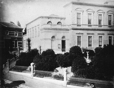
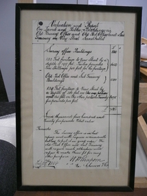
Document - VALUATION AND REPORT ON LAND AND PUBLIC BUILDINGS, 1888
... Framed document, valuation and report on land and public... DOCUMENT Certificate public buildings Framed document, valuation ...Framed document, valuation and report on land and public buildings vis old survey office and Post Office and sub Treasury in View Street Sandhurst, hand written in black ink and signed N P Simpson Feby 22nd 1888. Under glass in a thin black wooden frame.document, certificate, public buildings -
 Tatura Irrigation & Wartime Camps Museum
Folio, Tatura Mechanics Institute, Jun-01
... public building... was Tatura's first public building victory hall documents reports ...Mechanics Institute Hall opened 1881 was Tatura's first public buildingPhotographic and photocopiedrecords of archival materials covering development 1881-1972, 1977-1983victory hall, documents, reports -
 Buninyong & District Historical Society
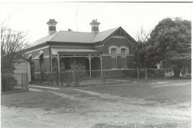
Photograph - B/W photograph, Mr C J Brooks, Former Police Station and residence, Scott St. Buninyong, July 1993
... Historic public building, built by Richard Rennie... public building, built by Richard Rennie, prominent local builder ...Historic public building, built by Richard Rennie, prominent local builderHistoric BuildingB/W Photo of former Police Station and Residence, built by Richard Rennie c1880, brick building, L-fronted, verandah, rendered cornice and window cappings.buninyong, police station, richard rennie, streetscape, scott st -
 Kew Historical Society Inc
Plan - Subdivision Plan, Riversdale Estate, 1939
... at right lists the major public buildings in the area: Burnely... Plan at right lists the major public buildings in the area ...The Kew Historical Society collection includes almost 100 subdivision plans pertaining to suburbs of the City of Melbourne. Most of these are of Kew, Kew East or Studley Park, although a smaller number are plans of Camberwell, Deepdene, Balwyn and Hawthorn. It is believed that the majority of the plans were gifted to the Society by persons connected with the real estate firm - J. R. Mathers and McMillan, 136 Cotham Road, Kew. The Plans in the collection are rarely in pristine form, being working plans on which the agent would write notes and record lots sold and the prices of these. The subdivision plans are historically significant examples of the growth of urban Melbourne from the beginning of the 20th Century up until the 1980s. A number of the plans are double-sided and often include a photograph on the reverse. A number of the latter are by noted photographers such as J.E. Barnes.The Riversdale Estate in Hawthorn created a subdivision of 20 allotments bordering on Riversdale Road and Riversdale Court (which was created by the subdivision). The Locality Plan at right lists the major public buildings in the area: Burnely Horticultural Gardens, Hawthorn Tram Depot and Railway Station, Scotch College and the River Yarra and The Boulevard.subdivision plans - hawthorn, riversdale estate -
 Buninyong & District Historical Society
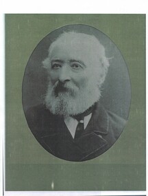
Photograph - Framed Photograph, Black and white photograph of Richard Rennie
... Rennie 1816-1906 of prominent public buildings in Buninyong... of prominent public buildings in Buninyong Richard Hutchinson Rennie ...A copy of a photograph of the well known builder Richard Rennie 1816-1906 of prominent public buildings in BuninyongRichard Hutchinson Rennie was a well known builder of public buildings including the Buninyong Town Hall/Court House 1886/7, Crown Hotel 1883 and the original Shire Hall 1869Black and white copy of an image of Richard Rennierichard rennie, buninyong town hall, public buildings -
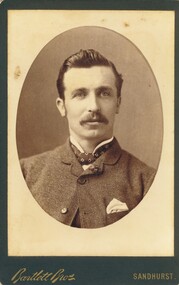 Bendigo Historical Society Inc.
Photograph - HARRIS COLLECTION: MALE PHOTO, Ninteenth Century
... , Sandhurst, Williamson Street, opposite Shamrock Hotel & New Public... Shamrock Hotel & New Public Buildings' printed on reverse ...Black & White studio photograph. Male aged early forties head & shoulders. Turned up collar with cravat. Buttoned jacket with handkerchief in pocket. Bartlett Bros Sandhurst printed on Front. Ornate scrolled 'Bartlett Bros, Photographers, Sandhurst, Williamson Street, opposite Shamrock Hotel & New Public Buildings' printed on reverse.Bartlett Bros Sandhurstphotograph, person, male -
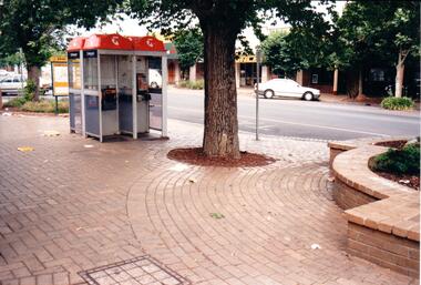 Hume City Civic Collection
Photograph, Late 1980's
... occurred on public buildings... occurred on public buildings vandalism evans street taxi ranks ...The series of seven photographs highlight examples of vandalism within the town centre precinct. Most of the vandalism occurred on public buildingsA coloured photograph of public telephones and the taxi rank in Evans Street. The telephone directories have been torn up an thrown around the brick pavement along with other litter. The trunk of an elm tree is in the middle of the photograph.vandalism, evans street, taxi ranks, public telephones, telstra, telecom, george evans collection -
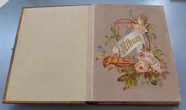 Bacchus Marsh & District Historical Society
Album, Jeremeas Family Album of Photographs of Bacchus Marsh and District in 1883 by Stevenson and McNicoll
... in Bacchus Marsh, public buildings like the Court House and Bacchus..., public buildings like the Court House and Bacchus Marsh Primary... and businesses in Bacchus Marsh, public buildings like the Court House ...In late 1883 the Melbourne based photographers Stevenson and McNicoll visited the Bacchus Marsh township and nearby districts. They are known to have been visiting the town in September 1883 and by November 1883 they were reported to have moved on to Myrniong and Ballan. During their visit they took numerous photographs. The images produced comprise scenes of shops and businesses in Bacchus Marsh, public buildings like the Court House and Bacchus Marsh Primary School, houses and their owners and several broader views of streets. The photos were then offered for sale. Photography businesses also sold albums for purchasers to display their photos.A unique and comprehensive set of images of people and places in the Bacchus Marsh town and district at a particular period in time, September-November 1883. This album of "carte de visites" photographs presents a rare compilation of the work of the Stevenson and McNicoll photography business. This team of photographers are known to have made several visits to towns and districts in the rural areas of Victoria and southern New South Wales in the 1880s and this album represents a very rare example of their non-portrait photography. The album is an example of the Victorian middle-class fashion to display family photographs for themselves and their visitors. These albums were often very expensive and in themselves evidence of the affluence of the family. They were made possible by the popularisation of photography as a social medium and were a forerunner of the coffee-table book. Medium sized leather-bound album, brown, front cover engraved with gold tooling in a starburst pattern. Pages are gold-lined. The inside front and end covers are in pale blue silk embossed with a gold floral pattern. The metal locking clasp is broken. The front page has a floral wreath of roses and forget-me-nots and a dragon-fly. The word "Album" is in the centre of the wreath, printed in gold in Gothic print. There are nine pages with pockets for four 65mm x 105mm sized "carte de visites" style photographs. Several feature pages have a single pocket for a larger photograph, or double pockets, possibly designed for family portraits. These portrait pages are also decorated with floral wreaths and insects, reflecting the theme of the frontispiece page. The smaller photos in the album were taken by the Melbourne photographers Stevenson and McNicoll, There are 48 of these smaller images. The images were created around September 1883 when photographers for Stevenson and McNicoll are known to have visited Bacchus Marsh and district. The images comprise scenes of shops and businesses in Bacchus Marsh, public buildings like the Court House and Bacchus Marsh Primary School, houses with their owners and several broader views of streets. References to various photos being created and being available for sale are mentioned in the Bacchus Marsh Express newspaper during September to November 1883. Each smaller photo has printed on the verso: Light & Truth. Copies of this Portrait can be had at any time by sending the Name and Post Office Money Order or Stamps for the amount of order to Stevenson & McNicoll, late Benson & McNicoll, Photographers. 108 Elizabeth Street, Melbourne.bacchus marsh vic. history, streetscapes, shops bacchus marsh vic., roads and streets bacchus marsh vic., stevenson and mcnicoll photographers, stevenson and mcnicoll 1883 photographs of bacchus marsh and district