Showing 242 items
matching quartz reef
-
 Rutherglen Historical Society
Image, c1990
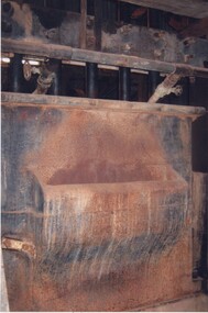
... . The battery's purpose was to crush quartz from nearby quartz reefs.... The battery's purpose was to crush quartz from nearby quartz reefs ...This photograph is of Battery Box, showing the mouth where quartz is fed in. The five stamper rods can also be seen. This is one of a series of photographs of the Rutherglen Gold Battery. The battery's purpose was to crush quartz from nearby quartz reefs and extract gold from within. The battery was erected in 1908 and consists of a five-head battery, Wilfrey table, Bergin pan, portable steam engine and shed. The battery was restored in 2011/12 and can be viewed daily between 9.00am and 5.00pm. See website for details. Colour photograph of a large piece of machinery inside a buildinggold battery, gold processing -
 Rutherglen Historical Society
Image, c1990
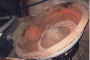
... was to crush quartz from nearby quartz reefs and extract gold from.... The battery's purpose was to crush quartz from nearby quartz reefs ...This photograph is of the Burdun Pan where small quantities of quartz material can be crushed. The Pan revolves and the large manganese iron ball does the crushing. This is one of a series of photographs of the Rutherglen Gold Battery. The battery's purpose was to crush quartz from nearby quartz reefs and extract gold from within. The battery was erected in 1908 and consists of a five-head battery, Wilfrey table, Bergin pan, portable steam engine and shed. The battery was restored in 2011/12 and can be viewed daily between 9.00am and 5.00pm. See website for details. Colour photograph of a metal pan, mounted on a geared shaft, with a metal ball.gold battery, gold processing -
 Rutherglen Historical Society
Image, c1990
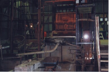
... . The battery's purpose was to crush quartz from nearby quartz reefs.... The battery's purpose was to crush quartz from nearby quartz reefs ...This photograph is a general view of the machinery of the Gold Battery. The Bergin Pan is on the left, Stamper Box and in foreground concrete bed for Wilfrey table which has been removed. This is one of a series of photographs of the Rutherglen Gold Battery. The battery's purpose was to crush quartz from nearby quartz reefs and extract gold from within. The battery was erected in 1908 and consists of a five-head battery, Wilfrey table, Bergin pan, portable steam engine and shed. The battery was restored in 2011/12 and can be viewed daily between 9.00am and 5.00pm. See website for details.Colour photograph of a number of large pieces of machinery inside a buildinggold battery, gold processing -
 Rutherglen Historical Society
Image, c1990
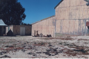
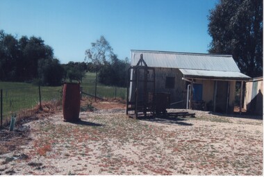
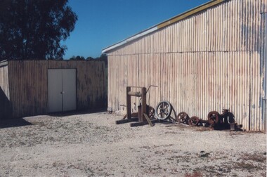
... from nearby quartz reefs and extract gold from within... from nearby quartz reefs and extract gold from within ...This photograph is of the side of the main building of the Gold Battery with workshop at rear (now demolished). Beside building is a hand windlass, along with some old pulleys and various parts. This is one of a series of photographs of the Rutherglen Gold Battery. The battery's purpose was to crush quartz from nearby quartz reefs and extract gold from within. The battery was erected in 1908 and consists of a five-head battery, Wilfrey table, Bergin pan, portable steam engine and shed. The battery was restored in 2011/12 and can be viewed daily between 9.00am and 5.00pm. See website for details.Colour photograph of the side of a corrugated iron building with a smaller building at the left, and a number of pieces of machinery next to the buildinggold battery, gold processing -
 Rutherglen Historical Society
Image, c1990
... . The battery's purpose was to crush quartz from nearby quartz reefs.... The battery's purpose was to crush quartz from nearby quartz reefs ...This photograph shows the workers' amenities at the Gold Battery. The building has a bedroom and kitchen. In front is a Baler Bucket and a cage. This particular cage was for raising and lowering the skips which brought the material to the surface. This is one of a series of photographs of the Rutherglen Gold Battery. The battery's purpose was to crush quartz from nearby quartz reefs and extract gold from within. The battery was erected in 1908 and consists of a five-head battery, Wilfrey table, Bergin pan, portable steam engine and shed. The battery was restored in 2011/12 and can be viewed daily between 9.00am and 5.00pm. See website for details.Colour photograph of a corrugated iron cottage, with several pieces of machinery around it.gold battery, gold processing -
 Rutherglen Historical Society
Image, c1990
... from nearby quartz reefs and extract gold from within... from nearby quartz reefs and extract gold from within ...This photograph is of the back end of the side of the main building of the Gold Battery with workshop at rear (now demolished). Beside building is a hand windlass, along with some old pulleys and various parts. This is one of a series of photographs of the Rutherglen Gold Battery. The battery's purpose was to crush quartz from nearby quartz reefs and extract gold from within. The battery was erected in 1908 and consists of a five-head battery, Wilfrey table, Bergin pan, portable steam engine and shed. The battery was restored in 2011/12 and can be viewed daily between 9.00am and 5.00pm. See website for details.Colour photograph of the side of a corrugated iron building with a smaller building at the left, and a number of pieces of machinery next to the buildinggold battery, gold processing -
 Rutherglen Historical Society
Image, c1990
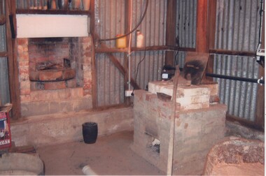
... nearby quartz reefs and extract gold from within. The battery... nearby quartz reefs and extract gold from within. The battery ...This photograph shows the pre-heater on the left and the furnace on the right. After clean up of stamper table, amalgam is placed in a retort, then placed in the furnace where mercury is condensed and runs down the small pipe into an enamel bucket and can be reused. This is one of a series of photographs of the Rutherglen Gold Battery. The battery's purpose was to crush quartz from nearby quartz reefs and extract gold from within. The battery was erected in 1908 and consists of a five-head battery, Wilfrey table, Bergin pan, portable steam engine and shed. The battery was restored in 2011/12 and can be viewed daily between 9.00am and 5.00pm. See website for details.Colour photograph of the interior of a room with corrugated iron walls, with a fireplace on the left and a furnace on the right.gold battery, gold processing -
 Flagstaff Hill Maritime Museum and Village
Ephemera - Miner's Right - Collins, 1888
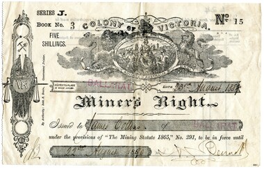
... quartz reefs in the colony.” A James Collins (1842-1918... quartz reefs in the colony.” A James Collins (1842-1918 ...This Miner’s Right was issued post the rush of the 1850s-60s but is testament to the ongoing interest in gold although the great rush had dwindled. Local papers continued to report on findings and hopes of success, including syndicates and explorations across the south-west district of Victoria and Otways. The Warrnambool correspondent of the “Hamilton Spectator”, 31/1/1878, p4 attest to the price of a good season of potatoes comparing “favourably with the unsteady returns of any precarious gold-bearing quartz reefs in the colony.” A James Collins (1842-1918) is listed in the Pioneers’ Register, Warrnambool, Township and Shire 1839-1900, Volume One, A.I.G.S Warrnambool Branch, 2004, p137. As are numerous other Collins pioneer families of the district. This item is significant in that it illustrates that people associated with the region were interested in taking their chances in prospecting for gold similar to many others. A lure that is still present for some today. Although the southwest region found it's source of wealth in other industries from whaling and fishing, wool and other agricultural pursuits. This is a top to bottom upright image of a Miner’s Right. It is a buff coloured document printed in black ink. It was issued in “BALLARAT” and rubber stamped twice in red ink. The issue to “James Collins”, is dated “23rd August 1889” to “22nd August 1890”. The signature of the authority could be Bennet. All handwriting is script style in black ink. Looking from the front the lefthand side has a serrated edge. The back is printed in black ink and there are no “particulars of registration”. The Miner’s Right is from “Series J, Book No. 3, ticket “No. 15”. A “Colony of Victoria” coat of arms is displayed at the top of the document. An insignia runs along the lefthand side of the license featuring coat of arms with a kangaroo and emu, then a miner’s pick and shovel, two crossed Union Jack flags sit behind a monogram “VR” with a hanging set of scales supported by a sword. "By Authority Robt. S. Brain, Government Printer.""Series J. Book No. 3 Five Shillings. No. 15. Colony of Victoria. Miner's Right"flagstaff hill, warrnambool, shipwrecked coast, flagstaff hill maritime museum, maritime museum, shipwreck coast, flagstaff hill maritime village, great ocean road, james collins, australian goldfields, miner's rights, the history of ballarat, gold rush -
 Warrnambool and District Historical Society Inc.
Financial record - Receipt: Grassmere Gold Mining Company, 1898
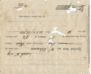
... . The gold-bearing quartz reefs were discovered in 1885 and worked... kilometres north west of Swifts Creek. The gold-bearing quartz reefs ...Grassmere is a small hamlet about 12 kilometres from Warrnambool. It is a farming area. The Grassmere Gold Mining Company, presumably established by local people in Grassmere, was created in 1898 for the purpose of acquiring from Messrs James and Mewha a lease of a Cassilis gold mine (23 acres). The Manager of the Company was Horatio Dickson of Melbourne and the brokers were McMeekin and Co. of Melbourne and Warrnambool and Dickson and Osborne of Melbourne. This reef mine was one of several in Cassilis, Gippsland, 12 kilometres north west of Swifts Creek. The gold-bearing quartz reefs were discovered in 1885 and worked to 1914. It is not known whether the Grassmere Cassilis mine was a financial success but the mining operations were impeded by the hardness of the stone in the area. William Robinson was a farmer in the Grasmere area. This receipt is of considerable interest as one of only three items the Warrnambool and District Historical Society that is connected to the establishment of the Grassmere Gold Mining Company. The gold mine establishment was one of the many minor events in the district in the 1890s. This is an 1899 receipt for William Robinson upon payment of six shillings and three pence, being part payment for shares in the Grassmere Gold Mining Company. The buff-coloured paper has black printing and black-ink handwriting. There are two stamps – one is the stamp of ‘H.S.Dickson’ and the other is the stamp of the ‘Grassmere Gold Mining Company, No Liability’. The certificate has silver fish damage at the top and the right-hand side‘May 30th 1899, Received from Mr Wm. Robinson the sum of six shillings and three pence, being the amount of 5th call of 1½ per share, due on 50 shares, nos. 12651/12700 in the above company, H.S. Dickson, Manager’grassmere, grassmere gold mining company, william robinson, warrnambool -
 Rutherglen Historical Society
Post Card, W. Hine Bookseller, 1904
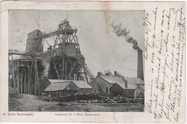
... 200 miners. There are several rich quartz reefs here which... rich quartz reefs here which are now receiving attention ...Black and white postcard photograph of the above ground structures of the Great Southern Mine.Printed below photograph: "W. Hine, Rutherglen" "Southern No. 1 Mine, Rutherglen" Written to the right of the photo: "Rutherglen, 21/8/04. This mine is one of a number of rich alluvial mines near R'glen. It employs, when working full swing, about 200 miners. There are several rich quartz reefs here which are now receiving attention" On back of card: "Miss F. Burgum, 74 Railway St., West Melbourne" Also a 1d postage stamp with a postmark Melbourne, 22/8/04gold mining, great southern, mine structures -
 Warrnambool and District Historical Society Inc.
Document, Receipt March 11 1899, 1898
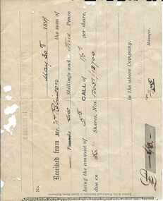
... . The gold-bearing quartz reefs were discovered in 1885 and worked.... The gold-bearing quartz reefs were discovered in 1885 and worked ...Grassmere is a small hamlet about 12 kilometres from Warrnambool. It is a farming area. The Grassmere Gold Mining Company, presumably established by local people in Grassmere, was created in 1898 for the purpose of acquiring from Messrs James and Mewha a lease of a Cassilis gold mine (23 acres). £5000 was to be raised in shares of five shillings and one shilling each. The Manager of the Company was Horatio Dickson of Melbourne and the brokers were McMeekin and Co. of Melbourne and Warrnambool and Dickson and Osborne of Melbourne. This reef mine was one of several in Cassilis, Gippsland, 12 kilometres north west of Swifts Creek. The gold-bearing quartz reefs were discovered in 1885 and worked to 1914. It is not known whether the Grassmere Cassilis mine was a financial success but the mining operations were impeded by the hardness of the stone in the area. William Robinson was a farmer in the Grasmere district. This receipt is of considerable interest as one of only three items the Warrnambool and District Historical Society has that is connected to the Grassmere Gold Mining Company. The gold mine establishment was one of the minor events in the district in the 1890s. This is a buff-coloured 1899 receipt for William Robinson who has paid six shillings and threepence for part payment of his shares in the Grassmere Gold Mining Company. The receipt has black printing and black-ink handwriting. There is one stamp of the Manager ‘H.S. Dickson’ and another of ‘Grassmere Gold Mining Company No Liability’. The receipt has several holes caused by silver fish damage. ‘March 11th 1899, Received from Mr Wm. Robinson the sum of six shillings and threepence being the amount of 3rd call of 1½ per share due on 50 shares nos. 12651/12700 in the above Company, H.S.Dickson, Manager’ grassmere, grassmere gold mining company, william robinson -
 Warrnambool and District Historical Society Inc.
Document, Share Certificate
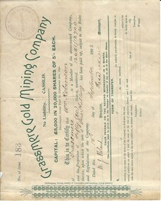
... . The gold-bearing quartz reefs were discovered in 1885 and worked.... The gold-bearing quartz reefs were discovered in 1885 and worked ...Grassmere is a small hamlet about 12 kilometres from Warrnambool. It is a farming area. The Grassmere Gold Mining Company, presumably established by local people in Grassmere, was created in 1898 for the purpose of acquiring from Messrs James and Mewha a lease of a Cassilis gold mine (23 acres). £5000 was to be raised in shares of five shillings and one shilling each. The Manager of the Company was Horatio Dickson of Melbourne and the brokers were McMeekin and Co. of Melbourne and Warrnambool and Dickson and Osborne of Melbourne. This reef mine was one of several in Cassilis, Gippsland, 12 kilometres north west of Swifts Creek. The gold-bearing quartz reefs were discovered in 1885 and worked to 1914. It is not known whether the Grassmere Cassilis mine was a financial success but the mining operations were impeded by the hardness of the stone in the area. William Robinson was a farmer in the Grassmere district. This certificate is of considerable interest as one of only three items the Warrnambool and District Historical Society has that is connected with the establishment of the Grassmere Gold Mining Company. The gold mine establishment was one of the many minor events in the district in the 1890s. This is a small buff-coloured certificate detailing the shares of William Robinson in the Grassmere Gold Mining Company (1898). The certificate has green printing and black-ink handwriting. The bottom section (Form of Transfer) is not filled in. There is a stamp of the Grassmere Gold Mining Company with the words ‘No Liability’. There is a decorative pattern in green on the left margin with the address of the company and the name of the printer. ‘This is to certify that Wm. Robinson of Grassmere is a member of the above-named company and the proprietor of fifty (50) shares, numbering 12651/12700 therein, upon which the sum of one shilling has been paid up, subject to the Rules and Regulations of the Company. Dated this 15th day of September, 1898. W.J. Roland, Director, .H. (es) Dickson, Manager.’grassmere, grassmere gold mining company, william robinson, warrnambool -
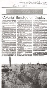 Bendigo Historical Society Inc.
Newspaper - LONG GULLY HISTORY GROUP COLLECTION: COMMUNITY FOCUS - COLONIAL BENDIGO ON DISPLAY
... . showing the excavation of quartz reef and mine buildings near Iron... 1875. showing the excavation of quartz reef and mine buildings ...Copy of a newspaper article titled Colonial Bendigo on display. Date written at the top of the page Dec 1 - 1984. Article mentions an exhibition organised by the Bendigo Art Gallery of the early photographers on the gold field. Wet plate photography was used. Other mediums were also used such as engraving, artists drawings, lithography, water colours and diorama. Artists mentioned are George Rowe, S T Gill, Alex Fox, Nicholas Caire, Wet Plate Photography, Thomas Ham, Edwin Stocqueler and Ludwig Becker. There is also a photo by Nicholas Caire, taken 1875. showing the excavation of quartz reef and mine buildings near Iron bark Hill.bendigo, history, long gully history group, the long gully history group - community focus - colonial bendigo on display, bendigo art gallery, george rowe, s t gill, alex fox, nicholas caire, wet plate photography, thomas ham, edwin stocqueler, the advertiser, ludwig becker, burke and wills expedition, mine buildings near ironbark hill, victoria hill -
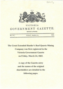 Bendigo Historical Society Inc.
Document - GREAT EXTENDED HUSTLERS: GAZETTE ENTRY OF NAMES OF ORIGINAL SHAREHOLDERS
... shareholders in the Great Extended Hustlers Reef Quartz Mining Co... Extended Hustlers Reef Quartz Mining Co., first registered ...Display copy (3 pages) of the names of the original shareholders in the Great Extended Hustlers Reef Quartz Mining Co., first registered in the Victoria Government Gazette on Friday March 24, 1865.bendigo, mining, great extended hustlers -
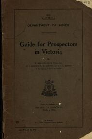 Federation University Historical Collection
Book, Guide for Prospectors in Victoria, 1931, 1931
... deposits, quartz reefs, indicators, economic minerals, assistance... quartz reefs alluvial deposits indicators victorian goldfields ...The handbook was intended for those with little experience who wanted to prospect of fossick.Grey soft covered book of 90 pages. Includes fold out map of a portion of Victoria showing auriferous areas and mineral localities. Also show Counties of Victoria and localities of minerals such as tin, antimony, copper, silver lead, Malybdenite, tungsten ores, manganese, platinum, osmiridium and iron. Chapter heading s include: working alluvial deposits, equipment, geology of Victoria, gold deposits, quartz reefs, indicators, economic minerals, assistance to prospectors, Miners' Right, mining bye-law, mining leases, forest regulations and glossary. Descriptions are given of a god dish, puddling tub, cradle, puddling machine, ground sluicing, boring, windlass, whim, hand dollying, sweeping, California pump, and wing dam.mining, baragwanath, gold, prospector, geology, quartz reefs, alluvial deposits, indicators, victorian goldfields, miners rights, mining leases, forest regulations, sluicing, sluice box, puddling machine, miner's cradle, whim, whip, california pump, gold nuggets, saddle reef, ballarat indicators, state batteries -
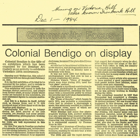 Bendigo Historical Society Inc.
Document - LONG GULLY HISTORY GROUP COLLECTION: COLONIAL BENDIGO ON DISPLAY
... , taken in 1875, showing the excavation of quartz reef and mine..., taken in 1875, showing the excavation of quartz reef and mine ...Copy of an Advertiser Article titled Colonial Bendigo on display. The article mentions an exhibition organised by the Bendigo Art Gallery to celebrate Victoria's 150th anniversary. Mentioned are the artists George Rowe and S T Gill. The photographers Alex Fox and Nicholas Caire. Thomas Ham introduced engraving in a commercial capacity. Edwin Stocqueler and Ludwig Becker are also mentioned. Written above the article is: Mining on Victoria Hill, also known as Ironbark Hill. Dec 1 - 1984. On the back glass plates are mentioned. Also S T Gills water colours, lithographs and engravings. There is a photograph by Nicholas Caire, taken in 1875, showing the excavation of quartz reef and mine buildings, popper legs and chimneys near Ironbark Hill.bendigo, history, long gully history group, the long gully history group - colonial bendigo on display, bendigo art gallery, george rowe, s t gill, alex fox, nicholas caire, thomas ham, edwin stocquelerthe advertiser, ludwig becker, burke and wills, victoria hill, ironbark hill -
 Bendigo Historical Society Inc.
Photograph - MINERS AT WORK: BENDIGO
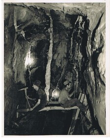
... - note white quartz reef on wall face ' On small paper... - note white quartz reef on wall face ' On small paper inclusion ...black and white photograph of two workmen seated on bush timber fitted between vertical rock faces. The ladder is probably from the level immediately below. The lamps are ' Bendigo bucket carbide lamps ' Some advisers consider consider that this photograph is posed as workers are not safely placed. In grey lead ' miners at work ' down below' in Bendigo ' a signature ' J.J. Stanistreet ' a caption ' Hercules Mine ' ? On back in black pen ' miners shaping shaft prior to ' boxing in' with red gum slabs - note white quartz reef on wall face ' On small paper inclusion ' Miners placing staging for stoping on spurs' Mining Revival C 1930's.. James Lerk 26 Nov. 1999 - not as described in ink on rear 'person, group, mining -
 Bendigo Historical Society Inc.
Document - ALBERT RICHARDSON COLLECTION: EARLY HISTORY OF THE BENDIGO GOLDFIELD
... the first gold discovery, how gullies were worked, quartz reefing... include the first gold discovery, how gullies were worked, quartz ...Typed foolscap two sided document with information about the early history of the Bendigo Goldfield. Topics include the first gold discovery, how gullies were worked, quartz reefing, gold cakes, hand dollies and Chilian mills. Some brief statistics of the Bendigo goldfield include the total gold yield of 17,370,561 ounces plus 5,000,000 oz sold outside Bendigo. The greatest depth reached by any mine in the State, 4,593 feet below surface, or 3,700 feet below sea-level, was attained by the Victoria Quartz Company. About 100 shafts exceed a depth of 1,000 feet, of which 40 are between 2,000 and 3,000 feet deep, fifteen are between 3,000 and 4,000 feet and two are over 4,000 feet.bendigo, mining, mines department -
 Stawell Historical Society Inc
Photograph, Main Street Stawell looking West c1907. Kay's Star Hotel on Right
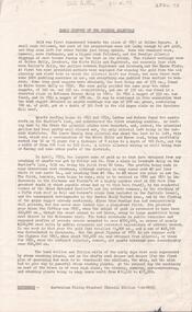
... to Main Street Quartz Reefs in 1860 and had many tenants over... to Main Street Quartz Reefs in 1860 and had many tenants over ...Main Street Looking West. Kays Star Hotel c1907 The Star Hotel had a chequered life. Like a number of other hotels it started life on Commercial Street Pleasant Creek, the first License being held by Mr. William Francis in 1858. It was shifted to Main Street Quartz Reefs in 1860 and had many tenants over a long period. For many years it stood in the centre of the roadway in Main Street and had to be moved to give more room for traffic. It is one of the reasons we have a bend in the Main Street. As a Hotel it had 54 years without a conviction against it. Although it had many licensees it was owned by one family for the last 27 years of its life as a Hotel. It was delicensed in 1916 because it was too close to the Albion which was a better building. Currently (2025) occupied by the Stawell Club and is licensed. The walkway beside it to the carpark is names Star Lane.Main Street Stawell looking West c1907. Bull & Mouth Hotel with verandahs on Left, Kay's Star Hotel on Right. Group of men talking in roadway at right. Telegraph pole prominent near centre of photo.Main St. Stawell Looking West.stawell, hotel -
 Federation University Historical Collection
Plan, White Horse Range Ballarat, 1885, 06/1885
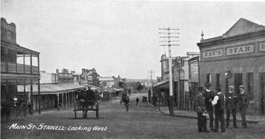
... leads, rivers, streets and topography. Quartz reefs include.... Quartz reefs include: Yorkshire, Try Again, Promised Land ...Two plans .1) Plan of the Ballarat Goldfields showing leads, rivers, streets and topography. Quartz reefs include: Yorkshire, Try Again, Promised Land, Western Slates, Norwegian, Robert's Lode, Finn's, Band and albion, Rothschild, Old Post Office, Queen Lode. Leads include: Navy jacks, Gays, Canadian, Prince Regent, Sailors Gully, White Horse, Little White Horse, Milkmans, Nightingale, Golden Point, Gravel Pits. Scale is 8 Chains to 1 inch .2) Plan showing lines of quartz reefs, alluvial workings and leads, White Horse Range, Ballarat. Leads include White Horse LEad, Little White Horse Lead, One Eye Gully, Terrible Lead, Sailor's Gully, Canadian Lead, Prince Regent Gully, Canadian Lead, Cavs Lead, Navy jacks Lead, Eureka Lead, Old Gravel Pits Lead, Gravel Pits Lead, Nightingale Lead, Malakoff Lead, Milkmans Lead, Redan Lead, Woolshed Lead, Jacksons Lead, Winters Lead, SCtochman's Lead, Canadian Lead. Reefs include: Promised Land, Daniash, Sir Garnet Wolsley, Norwegian, Rothschile, Band and Albion, Finns, Llanberis, Roberts Lode, Tynworths and Black Hill, Oregan, Yorkshire, Try Again, Yorkshire, Post Office, Clarke's, Western Slates, Black Slate, Danks Slates, Eastern Slates, Queen's Lode, Fire Brigade. Mines include Red Streak, New Chum, Tinworths, Woah Hawp, Normanby, Speedwell, Llanberris Extended, Llanberis, Last Chance, Major, Countess, Pioneer and a number of batteries along Main Road Hills include: Mount Clear, Pennyweight Hill, Sovereign Hillballarat, plan, white horse range, white horse, goldfields, mines, reefs, indicators, leigh river, cgt, tinworth, mining -
 Bendigo Historical Society Inc.
Document - JOAN O'SHEA COLLECTION: VICTORIA HILL GOLDMINING AREA BOOKLET, March 1972
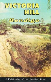
... on the Richest Quartz Reef in Bendigo, from 1854 to 1916. Colour.... Victoria Hill Bendigo Gold Mining on the Richest Quartz Reef ...Joan O'Shea Collection. Victoria Hill Bendigo Gold Mining on the Richest Quartz Reef in Bendigo, from 1854 to 1916. Colour and Black and White Booklet 16 Pages. Includes Maps of the Victoria Hill Area, photographs of the remains of a twenty head crushing battery, burnt ground from quartz roasting, The Victoria Quartz Mine Photograph from Australian Mining Standard June 1899, The compressor beds and concrete foundations for the poppet legs all that remain today of the Victoria Quartz Mine deepest mine on Bendigo Goldfield 4613 feet or 1406.04 metres. Also included photograph of the view of Victoria Hill from The New Chum Hill in the 1870s. The Location of the 3 mines Ballerstedt's open cut, North Old Chum and Lansell's 180 are marked. A depiction of Rae's Open Cut gives an understanding of the primitive nature of early workings on the Goldfields. The Booklet also provides a brief history of Victoria Hill itself.Bendigo Trust Publication March 1972. Printed in Bendigo Cambridge Press.bendigo, mining, victoria hill -
 The Beechworth Burke Museum
Photograph, Unknown
... as Castle Reef, Castle Point, and Raspberry Creek, which developed... as Castle Reef, Castle Point, and Raspberry Creek, which developed ...The A1 Gold Mine is located north of Woods Point, near Jamieson, in the Upper Goulburn region of Victoria. Gold was discovered at the A1 site in 1861 and mining operations began in 1864. The A1 Mine Settlement refers to a small township known variously as Castle Reef, Castle Point, and Raspberry Creek, which developed in the 1860s around mining industry centred on a crushing machine that worked the three gold reefs in the area. Historically, the name "A1"referred to the high quality of gold found in the quartz reefs at depths of at least two thousand feet. Along with the Morning Star mine at Woods Point, the A1 gold mine produced almost sixty percent of Victoria's gold output in the 1950s to 1970s and continued operating until 1992 when it went into administration. Operations at the site were revived in 2016 and the A1 Mine is now considered one of Victoria's premier gold mines. The A1 mine is part of the extensive and prospective Lachlan Fold Belt, a north-west trending belt of tightly folded Early Devonian sedimentary rocks extending from New South Wales to Victoria. Mineralisation is hosted within or immediately adjacent to diorite dykes. Contemporary development of the 'Queens Lode' at the A1 mine signals a move from high-grade, narrow vein airleg mining into larger scale, mechanical mining designed to increase ore production volume. This original, undated photograph of the A1 Mine appears to depict an area or phase of disuse or abandonment. The aged and humble appearance of the cottage suggests association with the historical A1 Mine Settlement, therefore the image may have been taken prior to the 1950s-1970s revival period in which the A1 mine is known to have produced high gold yields. The photograph contributes to our understanding of the A1 Gold Mine's impact on the landscape and the social, environmental impacts of mining on communities and may be compared with others in the Burke Museum's extensive collection of mining photographs to deepen our understanding of mining in the Jamieson area.Black and white rectangular photograph printed on photographic paperReverse: 5577 / A1 Mine / Near Jamieson / Vic. /burke museum, beechworth museum, beechworth, gold fields, gold rush, victorian gold rush, mining tunnels, gold ming history, colonial australia, australian gold rushes, mining technology, beechworth historic district, indigo gold trail, indigo shire, upper goulburn shire, jamieson, woods point-walhalla goldfield, a1 gold mine, victorian high country, modern mining methods, orogenic gold province, gold mineralisation, devonian, dykes -
 Bendigo Historical Society Inc.
Document - THE JOHN BROWN KNITWEAR FACTORY AND ITS HISTORICAL ASSOCIATIONS
... ; Big 180 mine; Victoria Reef Quartz mine; Victoria Quartz...; Big 180 mine; Victoria Reef Quartz mine; Victoria Quartz ...''The John Brown Knitwear Factory and its Historical Associations'' (A Richardson), a. Two pages of typed text; b. Two pages of hand-written text. References to: New Chum mine; Victoria mine; Big 180 mine; Victoria Reef Quartz mine; Victoria Quartz company; Little 180 mine; New Chum and Victoria crushing battery; ''Jeweller's Shop''; Advance mine;A. Richardsonbendigo, business, john brown knitwear, victoria hill, little 180 mine, new chum and the victoria crushing battery, marong road -
 Federation University Historical Collection
Book - Ledger, Ballarat School of Mines Assay and Analysis Ledger, 1887-1890, 1887-1890
... on sample quartz drillings from quartz reef submitted by H. Morris...' assay report on sample quartz drillings from quartz reef ...The Ballarat School of Mines had a 'Model Mine' that was used to teach students. Practical work was undertaken for a fee, supervised by laboratory superintendents. Copies of assays undertaken are compiled together in this book. Leatherbound ledger with transfer copies assay reports from the Ballarat School of Mines. Those seeking assaying work from the Ballarat School of Mines are listed in alphabetical order in the front of the ledger. The ledger contains 543 pages. .2) Foolscap assay report on foolscap Ballarat School of Mines letterhead, and signed by Alfred Mica Smith, Superintendent of Laboratories. The report was on eight samples of Quartz submitted by R.C. Morgan, Scotts, Hotel, Melbourne .3) Assay report on Ballarat School of Mines letterhead, dated 14 August 1985, and signed by Andrew Berry, Registrar. The assay was supervised by Professor Alfred Mica Smith, and undertaken for James Burke, Broken Hill, New South Wales. .4) Assay report on Ballarat School of Mines letterhead, dated 18 August 1988, and signed by Alfred Mica Smith, Superintendent of Laboratories. The assay was undertaken on samples of Limonite submitted by James Burke and others, Broken Hill, New South Wales. The report includes information the the Ballarat School of Mines museum and the search for geological specimens from all Australian colonies for the collection. .5) A 'rough' assay report on samples of stone submitted by H. Major Senr, Wilcannia, New South Wales. 5) A 'rough' assay report on sample quartz drillings from quartz reef submitted by H. Morris, Egerton, and an sample of quartz and pyrites for determination by Professor Krause submitted by R.M. Serjeant. ballarat school of mines, a.c. allan, brittania g.m. co., s. body, black horse company, john m. bickett, william bell, james barker, w. bliss, w. bailey, william barrou, w.h. batten, w. bechervaise, band and albion, budd bros, charles barker, i. cahir, a. chamber, w. cahill, james coglan, d. clarke, a.w. dobbie, john dosett, john dunstan, j.a. evans, l. eggleton, charles forbes, d. fitzpatrick, e. ford, michael goold, j. graham, john greenwood, james hayes, ed hardy, arthur harvey, george hodges, john hall, jubilee gold mining company, krause, luplau, lempiere, mt lyell co, john law, ed meadway, john murray, j.h. middleton, c.m. miles, m. muir, e. mcmillan, w. mcdougall, c. napier, w.r. nicholls, napier freehold, w.b, ochiltree, oakleigh gold mining company, dr pinnock, c. quin, james ross, c.b. retallack, e. rowlands, royal standard, linton, frank rabling, william russell, charles soloman, f. selby, w.j. scott, sulieman pasha co, south clunes united, h.w. sinclair, george selby, e.h. schroeder, horsham, e.w. spain, c.h. sheary, sir henry loch gold mining company, a. sutherland, saxon consols, j.b. triggs, h. townsend, harold turnley, c. taylor, melbourne, c. thorpe, a. vandenberg, charles walker, charles wilson, thomas wellington, a. wynne, r. warne, e. wattis, john wood, walter warner, armidale, c. winterbottom, w.l. willliams, j.c. young -
![View of Victoria Hill, Bendigo, taken from Old Chum Hill / [by] Nicholas Caire, circa 1876](/media/collectors/550653872162f11fb04854aa/items/577752a3d0cdd10a5c16e654/item-media/57775308d0cdd10a5c171c46/item-fit-380x285.jpg) Kew Historical Society Inc
Kew Historical Society IncPhotograph, Anglo-Australasian Photographic Company, View of Victoria Hill, Bendigo, taken from Old Chum Hill, c. 1876
... of the principal Quartz-reef claims in the district of Bendigo... of the principal Quartz-reef claims in the district of Bendigo ...Nicholas Caire was born on Guernsey in the Channel Islands in 1837. He arrived in Adelaide with his parents in about 1860. In 1867, following photographic journeys in Gippsland, he opened a studio in Adelaide. From 1870 to 1876 he lived and worked in Talbot in Central Victoria. In 1876 he purchased T. F. Chuck's studios in the Royal Arcade Melbourne. In 1885, following the introduction of dry plate photography, he began a series of landscape series, which were commercially successful. As a photographer, he travelled extensively through Victoria, photographing places few of his contemporaries had previously seen. He died in 1918. Reference: Jack Cato, 'Caire, Nicholas John (1837–1918)', Australian Dictionary of Biography.An original, rare photograph from the series 'Views of Victoria: General Series' by the photographer, Nicholas Caire (1837-1918). The series of 60 photographs that comprise the series was issued c. 1876 and reinforced a neo-Romantic view of the Australian landscape to which a growing nationalist movement would respond. Nicholas Caire was active as a photographer in Australia from 1858 until his death in 1918. His vision of the Australian bush and pioneer life had a counterpart in the works of Henry Lawson and other nationalist poets, authors and painters.Albumen silver photograph on boardprinted in ink on support l.c.: VIEW OF STURT STREET, BALLARAT, TAKEN FROM THE TOWN HALL TOWER. / COPYRIGHT REGISTERED. printed in ink on support reverse c.: VIEWS OF VICTORIA. / (GENERAL SERIES.) / No. 13. / VIEW OF VICTORIA HILL, BENDIGO, TAKEN FROM OLD CHUM HILL. / This scene represents two of the principal Quartz-reef claims in the district of Bendigo, with their surface / excavations. The one nearest the foreground is the North Old Chum's Company's claim, which is very rich with / gold-bearing quartz. The other claim, on the hill side, is the private property of Mr. George Lansell, and is even / more valuable than the former, giving employment to over 100 men. The building on the right is the quartz-crushing / plant belonging to the new Chum and Victoria Companies. The excavations are several hundred feet in depth. printed in ink on support reverse l.c.l.: J.W. FORBES, Agent, printed in ink on support reverse l.c.: ANGLO-AUSTRALASIAN PHOTOGRAPHIC COMPANY, MELBOURNE. printed in ink on support reverse l.c.r.: 10 Temple Court, Collins Street West.nicholas caire (1837-1918), landscape photography, victoria hill - bendigo - victoria -
 The Beechworth Burke Museum
Photograph - Photograph - Reproduction, Unknown
... to work old or abandoned quartz reefs, often persisting without... to work old or abandoned quartz reefs, often persisting without ...This image is a reproduction of an 1899 original depicting the 'Williams Good Luck Mine' on the Mopoke Reef (also called 'Morepork Gully') in the Dingle Ranges, approximately three miles from Beechworth. The foreground of the image is littered with piles of smashed rock and detritus, known as ‘mullock’, beside a reinforced mine shaft, a vertical access passageway allowing miners to enter the mine and haul ore out using lifting technology such as a poppet heads, whims or windlasses. A group of miners and a dog appear close to an open-sided miner’s hut. Following the discovery of gold at Beechworth in 1852, rushes quickly followed at surrounding creeks and gullies in the district. In the late nineteenth and early twentieth centuries, small syndicates of miners continued to work old or abandoned quartz reefs, often persisting without the assistance of heavy machinery to remove the large amounts of rock, in order to obtain yields at ever greater depths. The group of miners in this photograph are Mr. Roger Williams and Sons, who revived operations at the ‘Old Good Luck’ mine on the Mopoke Reef in the Dingle Range near Beechworth around 1892, working the site for more than two decades. An emigrant from Cornwall with experience in the tin mining industry, 19 year old Roger Williams senior sailed to New Zealand in 1840, then to Australia where he spent time in the Bendigo Gold Fields before settling in Beechworth in the early 1860s. Mr Williams senior worked on various mining activities in the district, including the Rocky Mountain Tunnel project. Conversant with the character of gold-bearing reefs in the area, the syndicate dug an eight hundred foot tunnel, digging down as far down as two hundred feet with little capital save their labour, to connect and provide better working access to the mass of reefs and veins in the vicinity. Progress was hampered by poor air quality charged with fumes from dynamite and large quantities of rock had to be crushed to obtain payable yields. The Victorian Goldfields are filled with ruins and remnants of the area's rich mining history, ranging from small alluvial diggings to the remains of huge mining companies. Site names often changed several times throughout the nineteenth and twentieth centuries. Some sites were abandoned and forgotten, others were worked continuously over many decades. The names of mines were often repeated at different locations throughout the Victorian Goldfields. For example, there is a Mopoke Gully heritage mine near Fryers Creek, Victoria. 'Mopoke' is a common onomatopoeic name for Morepork and Australian Boobook owls. This image has historical, social and research significance for patterns of emigration during of the Victorian Gold Rush, and the historical, social and environmental impacts of mining at Beechworth at the turn of the nineteenth and twentieth centuries. As gold became scarce and government support and large company investment waned, poor hard-working miners laboured intensively to make a living through periods of high unemployment. This image can be compared and studied alongside other historical mining photographs and objects in the Burke Museum Collection. It has potential to improve our understanding of miners working conditions and the shifting character of mining in the Beechworth district. Black and white rectangular reproduction photograph printed on matte photographic paper.Obverse: Williams Good Luck Mine Beechworth / Roger! / Reverse: 6858 / burke museum, beechworth museum, beechworth, gold fields, gold rush, victorian gold rush, gold ming history, colonial australia, australian gold rushes, mining technology, beechworth historic district, indigo gold trail, migration, indigo shire, good luck gold mine, victorian goldfields, mining syndicates, gold fever, quartz-mining, small-scale mining, old good luck mine, mopoke gully, quartz reefs beechworth -
 The Beechworth Burke Museum
Photograph
... of miners continued to work old or abandoned quartz reefs, often... of miners continued to work old or abandoned quartz reefs, often ...This image is a reproduction of an 1899 original depicting the 'Williams Good Luck Mine' on the Mopoke Reef (also called 'Morepork Gully') in the Dingle Ranges, approximately three miles from Beechworth. A large opening to a mine can be seen behind the men in the photograph, with a wheeled cart on a track leading to the men's position, where the soil and rocks have been hauled away. This photograph interestingly contains dogs alongside the miners. While dogs have been recorded as deterrents to thieves in the Victorian goldfields, these dogs appear as companions to these men. Following the discovery of gold at Beechworth in 1852, rushes quickly followed at surrounding creeks and gullies in the district. In the late nineteenth and early twentieth centuries, small syndicates of miners continued to work old or abandoned quartz reefs, often persisting without the assistance of heavy machinery to remove the large amounts of rock, in order to obtain yields at ever greater depths. The group of miners in this photograph are Mr. Roger Williams and Sons, who revived operations at the ‘Old Good Luck’ mine on the Mopoke Reef in the Dingle Range near Beechworth around 1892, working the site for more than two decades. An emigrant from Cornwall with experience in the tin mining industry, 19 year old Roger Williams senior sailed to New Zealand in 1840, then to Australia where he spent time in the Bendigo Gold Fields before settling in Beechworth in the early 1860s. Mr Williams senior worked on various mining activities in the district, including the Rocky Mountain Tunnel project. Conversant with the character of gold-bearing reefs in the area, the syndicate dug an eight hundred foot tunnel, digging down as far down as two hundred feet with little capital save their labour, to connect and provide better working access to the mass of reefs and veins in the vicinity. Progress was hampered by poor air quality charged with fumes from dynamite and large quantities of rock had to be crushed to obtain payable yields. The Victorian Goldfields are filled with ruins and remnants of the area's rich mining history, ranging from small alluvial diggings to the remains of huge mining companies. Site names often changed several times throughout the nineteenth and twentieth centuries. Some sites were abandoned and forgotten, others were worked continuously over many decades. The names of mines were often repeated at different locations throughout the Victorian Goldfields. For example, there is a Mopoke Gully heritage mine near Fryers Creek, Victoria. 'Mopoke' is a common onomatopoeic name for Morepork and Australian Boobook owls.This image has historical, social and research significance for patterns of emigration during of the Victorian Gold Rush, and the historical, social and environmental impacts of mining at Beechworth at the turn of the nineteenth and twentieth centuries. As gold became scarce and government support and large company investment waned, poor hard-working miners laboured intensively to make a living through periods of high unemployment. This image can be compared and studied alongside other historical mining photographs and objects in the Burke Museum Collection. It has potential to improve our understanding of miners working conditions and the shifting character of mining in the Beechworth district.Sepia coloured rectangular photograph printed on gloss photographic paper mounted on card. Obverse: Williams/ Good/ Luck Reverse: A02498/ 1997. 2498/ Good Luck/ Mine/ 1899/ Mopoke. burke museum, beechworth museum, beechworth, gold fields, gold rush, victorian gold rush, gold ming history, colonial australia, australian gold rushes, mining technology, beechworth historic district, indigo gold trail, migration, indigo shire, good luck gold mine, victorian goldfields, mining syndicates, gold fever, quartz-mining, small-scale mining, old good luck mine, mopoke gully, quartz reefs beechworth -
 The Beechworth Burke Museum
Photograph
... to work old or abandoned quartz reefs, often persisting without... to work old or abandoned quartz reefs, often persisting without ...This image is a reproduction of an 1899 original depicting the 'Williams Good Luck Mine' on the Mopoke Reef (also called 'Morepork Gully') in the Dingle Ranges, approximately three miles from Beechworth. The foreground of the image is littered with piles of smashed rock and detritus, known as ‘mullock’, beside a reinforced mine shaft, a vertical access passageway allowing miners to enter the mine and haul ore out using lifting technology such as a poppet heads, whims or windlasses. A group of miners and a dog appear close to an open-sided miner’s hut. Following the discovery of gold at Beechworth in 1852, rushes quickly followed at surrounding creeks and gullies in the district. In the late nineteenth and early twentieth centuries, small syndicates of miners continued to work old or abandoned quartz reefs, often persisting without the assistance of heavy machinery to remove the large amounts of rock, in order to obtain yields at ever greater depths. The group of miners in this photograph are Mr. Roger Williams and Sons, who revived operations at the ‘Old Good Luck’ mine on the Mopoke Reef in the Dingle Range near Beechworth around 1892, working the site for more than two decades. An emigrant from Cornwall with experience in the tin mining industry, 19 year old Roger Williams senior sailed to New Zealand in 1840, then to Australia where he spent time in the Bendigo Gold Fields before settling in Beechworth in the early 1860s. Mr Williams senior worked on various mining activities in the district, including the Rocky Mountain Tunnel project. Conversant with the character of gold-bearing reefs in the area, the syndicate dug an eight hundred foot tunnel, digging down as far down as two hundred feet with little capital save their labour, to connect and provide better working access to the mass of reefs and veins in the vicinity. Progress was hampered by poor air quality charged with fumes from dynamite and large quantities of rock had to be crushed to obtain payable yields. The Victorian Goldfields are filled with ruins and remnants of the area's rich mining history, ranging from small alluvial diggings to the remains of huge mining companies. Site names often changed several times throughout the nineteenth and twentieth centuries. Some sites were abandoned and forgotten, others were worked continuously over many decades. The names of mines were often repeated at different locations throughout the Victorian Goldfields. For example, there is a Mopoke Gully heritage mine near Fryers Creek, Victoria. 'Mopoke' is a common onomatopoeic name for Morepork and Australian Boobook owls.This image has historical, social and research significance for patterns of emigration during of the Victorian Gold Rush, and the historical, social and environmental impacts of mining at Beechworth at the turn of the nineteenth and twentieth centuries. As gold became scarce and government support and large company investment waned, poor hard-working miners laboured intensively to make a living through periods of high unemployment. This image can be compared and studied alongside other historical mining photographs and objects in the Burke Museum Collection. It has potential to improve our understanding of miners working conditions and the shifting character of mining in the Beechworth district.Sepia coloured rectangular photograph printed on gloss photographic paper mounted on card.Obverse: Reverse: A02497/ 1997.2497/ 'Good/ Luck/ Mine'/ Morepork/ Gully/ Mrs Joyce/ Bright/ Tunnel/ 800 ft/ 1899. burke museum, beechworth museum, beechworth, gold fields, gold rush, victorian gold rush, gold ming history, colonial australia, australian gold rushes, mining technology, beechworth historic district, indigo gold trail, migration, indigo shire, good luck gold mine, victorian goldfields, mining syndicates, gold fever, quartz-mining, small-scale mining, old good luck mine, mopoke gully, quartz reefs beechworth -
 Ballarat Heritage Services
Photograph - Photograph - Colour, Steele's Pioneer Mine Ruins, Yandoit, 2016, 18/01/2016
... Steele's Reef was opened in 1859 along with a number... Reef Quartz Mining Company fixed steam pumping machinery ...Steele's Reef was opened in 1859 along with a number of other reefs in the Yandoit area. The reef was worked by small mining parties until the late 1880s. In 1887, the Steele's Reef Quartz Mining Company fixed steam pumping machinery and commenced sinking a shaft. The company were unable to find a profitable ore body and after two years work closed down. By this time their shaft had reached a depth of 150 feet. The mine was then taken over by the Pioneer Quartz Mining Company who appear not to have worked the mine. In 1906, the Steele's Pioneer Company commenced work, erecting a winding winch at the old shaft sunk by the Steele's Company. The next year the company erected a 10-head battery, set of poppet legs, a pumping engine. Sinking the shaft a further 100 feet, the company struggled to find payable ore and soon closed down.Colour photographs of the remnants of Steele's mine at Yandoit, Victoria. steele's mine, yandoit, mining, ruins -
 Federation University Historical Collection
Plan, Sulieman Pasha Co Plan Transverse Section
... ounces of gold, the twelfth highest quartz reef gold production... highest quartz reef gold production for any mine on the Ballarat ...The Sulieman Pasha is possibly named after the most important Sultan of the Ottoman Empire, Suleiman One, or Suleiman the Magnificent, when the Ottoman Empire was at its peak. Or potentially a number of Ottoman governors, statesmen and military commanders with the same name after, however the spelling is slightly different to the mine name. No Turkish connection was found relating to the formation of the company, and remains unconfirmed. The mine operated from two shafts; No. 1 near the corner of Humffray and Mair streets, and also near where the Welcome Nugget (2217 ounces) was found years earlier; and the controversial No. 2 shaft several blocks south bordering the northern side of the main highway through Ballarat. The company produced 62 666 ounces of gold, the twelfth highest quartz reef gold production for any mine on the Ballarat goldfield. Some crushing figure examples are January-June 1881: 3674 tonnes 1085 ounces; January-June 1885: 2949 tonnes 1281 ounces; July-December 1885: 4459 tonnes 1119 ounces; January-June 1887: 1869 tonnes 730 ounces; July-December 1892: 1450 tonnes 771 ounces; July-December 1896: 4365 tonnes 1372 ounces. Like many mines in the area, gold grades were low. John Watson was noted as mine manager in the 1880s, and John Williams 1890s. The company was re-organised twice increasing the number of shares from 4000 to 24 000, and increasing the capital available. The Sulieman Pasha Company was formed in 1878. David Fitzpatrick was given the honour of turning the first sod of both the No.1 and later No. 2 shafts. The first dividend was given to shareholders in July 1881. The company obtained a prospecting vote (government grant) to start, and was very proud to be the first Victorian gold mining company to pay the funds back to the government. The event was marked by a lavish banquet laid out for ministers and government officials by the company. Leases were purchased to the south in 1885 to the Llanberris Mine boundary, after poor results began accumulating from the small No. 1 shaft. To take advantage of this new land the company planned to sink a second shaft. Initially this was to take place on government land, but the uproar from nearby residents caused the company to purchase land along the Main Road (now Western Highway), and the old Yarrowee Hotel which had occupied the site since the alluvial digger days of the 1850's was demolished. The area had since those days become heavily occupied with a number of shops, houses, a post office, church and two schools in the immediate area. The thought of an underground mine next door drew considerable opposition. The company (before the days of public relations departments) wrote 'most people would have thought that progress as vital as mining would be supported by tradesmen whose business rely on the mining industry. It seems when it comes to mining they are bereft of their senses, and considering the low ebb of mining in Ballarat East, the action of our opponents are unaccountable. (Sarcastically) There are certain engineering difficulties in moving the quartz reefs to a new location, but if we could to appease our opponents we would'. The company also wanted to take over 4 acres of the St Paul's school oval for machinery, but accused the St Paul's Church of wanting extortionate amounts of money upfront, and on a yearly basis for the privilege. It stated the church could not be opposed to mining when several years earlier it had formed its own company to mine the land, only for shareholders to lose their money. In 1886, the company approached the Minister for Mines, and attended heated public meetings on the matter. The local residents, shop owners, and church submitted a 60 person petition to the local council and government authorities. They stated the shaft contravened the mining statutes, which stating no mining could take place within 150 yards of a public building or church. A speech by a resident stated 'mining always comes with glorious pictures of the great benefits which would accrue all parties concerned if their request is granted, but if property is destroyed or depreciated in value, no-one then comes forward and compensates them'. The No. 2 shaft was approved including taking over part of the school oval. In 1888, workers at the company's No. 2 shaft went on strike to try and bring their wages in line with other mines in the district (the No. 1 shaft was operated by tributers). William Madden (26) was killed from a fall of earth underground the same year, while a year later his father John Madden (70) was similarly killed in the Madame Berry Mine elsewhere in the district. In 1897 as the amount of gold being found fell away, it came to light part of the deal to purchase the Yarrowee Hotel site was a 5% royalty on gold found. Shareholders could not understand why they were paying a royalty to the former owners of the property. The mine closed in 1898 due to a lack of gold. In 1902 a boy (age unknown) called Charles Lee was killed from a fractured skull while working to dismantle the Sulieman Pasha plant. The fuss over the No. 2 shaft had a sequel. On the company winding up, the land was purchased by J.S. Trethowan who built a house next to the shaft. In 1907, the shaft caved-in creating a sinkhole immediately at the back of the house. A Mr Chamberlain heard a deep rumbling sound at 5am, and looked out the window to see his fowl house and thirteen chickens disappear down an expanding hole. He then went back to bed, and called the police later in the day. The shaft was 1050 feet deep, and the hole at the surface that developed was 20 feet by 17 feet across, and 20 feet depth. In 1930 it is reported a syndicate had been formed to clean out the old shaft, and re-open the mine. It is assumed this was the No. 1 shaft but no more was found. (https://www.mindat.org/loc-304239.html, accessed 07/08/2019) A transverse section plan of the Sulieman Pasha Mine.sulieman pasha company, plan, mining, united black hill mine, victoria united mine, victoria street, britannia united mine, last chance mine, llanberris mine, ottoman empire, john watson, john williams, david fitzpatrick