Showing 3251 items matching "road map"
-
 Bacchus Marsh & District Historical Society
Map, Gaynor Street Area Land Sales, Maddingley, 1888
... , Typpynge Street, Finn Street and East Maddingley Road. . The map... Street and East Maddingley Road. . The map is pasted ...This map was produced for a major sale of land in the Maddingley area of Bacchus Marsh in 1888. The sale was conducted by two firms from Melbourne, Carney and Kelly 12 Swanston Street Melbourne. and 'Richardson, Kerr & Co. 40 Flinders Lane Melbourne. 136 blocks were for sale.A single page paper map showing land allotments for sale in the Maddingley area of Bacchus Marsh. Locations shown include Gaynor Street, Maddingley Road South, Parwan Road, Mitchem Street, Typpynge Street, Finn Street and East Maddingley Road. . The map is pasted into a bound volume containing 76 maps or plans in total. High resolution digital image stored on BMDHS computer network. bacchus marsh victoria maps, maddingley victoria maps, land use, maddingley victoria history, land sales bacchus marsh, land sales maddingley -
 Bacchus Marsh & District Historical Society
Map, Gaynor Street Land Sales, Maddingley, circa 1880s-1890s
... , Typpynge Street, Finn Street and East Maddingley Road. . The map..., Typpynge Street, Finn Street and East Maddingley Road. . The map ...This map was produced for a major sale of land in the Maddingley area of Bacchus Marsh. The precise date of the sale has not been determined. Features present on the map such as the Bacchus Marsh Railway Station indicate the land sale must have taken place some time after 1887 when the Railway Station opened. A single page paper map showing land allotments for sale in the Maddingley area of Bacchus Marsh. Locations shown include Gaynor Street, Maddingley Road South, Parwan Road, Mitchem Street, Typpynge Street, Finn Street and East Maddingley Road. . The map is pasted into a bound volume containing 76 maps or plans in total. High resolution digital image stored on BMDHS computer network. bacchus marsh victoria maps, maddingley victoria maps, land use, maddingley victoria history, land sales bacchus marsh, land sales maddingley -
 Ringwood and District Historical Society
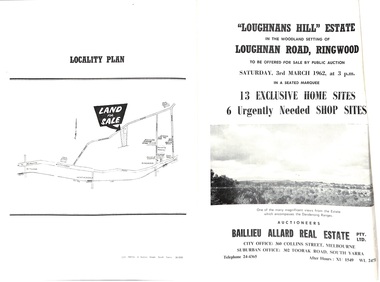
Document - Folder, Subdivision Auction - Loughnans Hill Estate 1962, Ringwood, Victoria
... Court and 6 shop sites in Loughnan Road, with map of subdivision... in Loughnan Road, with map of subdivision, terms of sale, and summary ...Double-sided bifold page advertising auction on Saturday 3rd March, 1962 - 13 residential allotments in Hearthside Court and 6 shop sites in Loughnan Road, with map of subdivision, terms of sale, and summary of features and services. Adjoining service station shown on accompanying Plan of Subdivision - Part of Crown Allotment 28 Parish of Warrandyte, also showing location of property known as "Hearth", hence Hearthside Court.Auctioneers - Baillieu Allard Real Estate Pty Ltd., 360 Collins Street, Melbourne, and 302 Toorak Road, South Yarra. Telephone 24-4365, After hours XU1549, WL2471. -
 Whitehorse Historical Society Inc.
Document, Municipal Chambers, Nunawading, 23/07/2001 12:00:00 AM
... Whitehorse Road, Nunawading, and of 13 Walkers Road, Nunawading... Road, Nunawading. Includes maps, plans, photos ...Papers relating to applications for Council permits, objections and VCAT hearingsPapers relating to applications for Council permits, objections and VCAT hearings concerning development of 360-362 Whitehorse Road, Nunawading, and of 13 Walkers Road, Nunawading. Includes maps, plans, photos and architectural assessment of 360 Whitehorse Road by Andrew Ward.Papers relating to applications for Council permits, objections and VCAT hearings associated planning consultants, arrowsmith, valda, nunawading and district historical society, municipal chambers, whitehorse road, nunawading, no 360, no 362, walkers road, no. 13, victorian civil and administrative tribunal, ward, andrew, city of whitehorse -
 Anglesea and District Historical Society
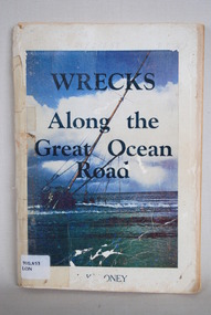
Book, J Loney, Wrecks Along the Great Ocean Road, 1967
... along the Great Ocean Road. Illustrated with both maps... Road. Illustrated with both maps and photographs ...Book first published in 1967 dealing with the shipwrecks along the Great Ocean Road. Illustrated with both maps and photographs and with a chrononolgy of the list of wrecks from pre-1800 through to 1958.Title: WRECKS / Along the / Great Ocean / Road J.K. LONEYjack loney, dewey no 910.453, book -
 Ringwood and District Historical Society
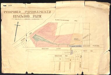
Map, Proposed Improvements to Ringwood Park (Ringwood Lake) dated 14 January 1927
... is incorrectly labelled Whitehorse Road. The map shows Rosedale Crescent... Dandenong Road is incorrectly labelled Whitehorse Road. The map ...Proposed Improvements to Ringwood Park (Ringwood Lake) dated 14 January 1927, signed Cr McCaskill. Main Road is Whitehorse Road (Maroondah Highway), and Mt Dandenong Road is incorrectly labelled Whitehorse Road. The map shows Rosedale Crescent and Railway Parade, both of which exist in 2024. On the bottom of the map, south of the railway line, showing proposed streets - Graham Road, Anderson Street and Adams Street - in preparation for the sale of the Theo Anderson property. That area is now Bedford Park. -
 Kew Historical Society Inc
Map, MMBW, MMBW Plan No.66 Kew, 1900-1910
... by Burke Road. The map shows the extent of urban development... Road, and in the east by Burke Road. The map shows the extent ...The Melbourne and Metropolitan Board of Works (MMBW) was established by an act of the Victorian Parliament in 1890 to prepare for and to implement a sewerage and water reticulation system across what was then inner Melbourne, its surrounding and middle distance suburbs, including Kew. The MMBW was disbanded in 1991.The map collection of the Kew Historical Society has at its core the historic maps assembled and originally stored in the City Engineer's Department of the City of Kew. These include maps in a number of scales. The vast majority of maps were produced by the MMBW in the first two decades of the twentieth century, and are solid working maps, backed by linen for durability. These maps are historically significant to Kew, the City of Boroondara and to the history of the development of state utilities in Victoria. A number of the Kew maps have additional details added by former municipal officers, including the levels reached by various floods. As these were working documents, information was added to them long after the period of their initial production and distribution.Early map of part of the Borough of Kew, created in the first decade of the twentieth century, at a scale 160 ft to 1 inch. The map covers what was then the south eastern part of Kew, bordered on its north by Adeney Avenue, in the west by Sackville Street, in the south by Barkers Road, and in the east by Burke Road. The map shows the extent of urban development by that time, prominent institutions and the outlines of built structures in the municipality. Contour lines were added in ink to the map at a later stage.MELBOURNE AND METROPOLITAN BOARD OF WORKS / PLAN NO. 66 / KEW melbourne & metropolitan board of works, mmbw maps, mmbw plans, borough of kew, cartography -
 Melbourne Tram Museum
Photograph - Digital Image, Public Transport Victoria (PTV), "Buses replace trams - route 58", Oct. 2020
... , map and road closures.... Park. Has details on the bus replacement services, map and road ...Digital Image of a pamphlet "Buses replace trams - route 58", November and December 2020 for the reconstruction of the tram track through Royal Park. Has details on the bus replacement services, map and road closures.trams, tramways, royal park, trackwork, track -
Port Melbourne Historical & Preservation Society
Flyer, Suggested ring road around Port, 2018 - 2019
... in community. . Flyer regarding proposed ring road around Port... road around Port Melbourne. Map of proposed route and listing ...These items were collected by a PMHPS member during 2018-19 and they have been retained as a group of ephemeraVarious ephemera of local interest showing changes in community. . Flyer regarding proposed ring road around Port Melbourne. Map of proposed route and listing key contact people. Campaign by Social Media Realty.built environment, ring road, social media ready -
 Melbourne Tram Museum
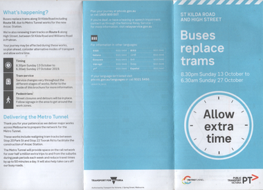
Pamphlet, Public Transport Victoria (PTV), "Buses replace trams - St Kilda Road and High Street", Oct. 2019
... Pamphlet - "Buses replace trams - St Kilda Road and High...Melbourne Tram Museum 8 Wallen Road Hawthorn melbourne ...Pamphlet - "Buses replace trams - St Kilda Road and High Street" - part of the Metro tunnel project works, Oct 2019 affecting mainly route 6 trams along with St Kilda Road routes. Includes a map of the work zone and bus replacement services.Demonstrates a passenger information document about trackworks.Pamphlet - 6 fold DL printed trams, tramways, st kilda road, high st, route 16, metro tunnel, trackworks -
 Kew Historical Society Inc
Map, MMBW, MMBW Plan No.67 Kew, 1900-1910
... by High Street, and in the east by (about) Belford Road. The map... by (about) Belford Road. The map shows the extent of urban ...The Melbourne and Metropolitan Board of Works (MMBW) was established by an act of the Victorian Parliament in 1890 to prepare for and to implement a sewerage and water reticulation system across what was then inner Melbourne, its surrounding and middle distance suburbs, including Kew. The MMBW was disbanded in 1991.The map collection of the Kew Historical Society has at its core the historic maps assembled and originally stored in the City Engineer's Department of the City of Kew. These include maps in a number of scales. The vast majority of maps were produced by the MMBW in the first two decades of the twentieth century, and are solid working maps, backed by linen for durability. These maps are historically significant to Kew, the City of Boroondara and to the history of the development of state utilities in Victoria. A number of the Kew maps have additional details added by former municipal officers, including the levels reached by various floods. As these were working documents, information was added to them long after the period of their initial production and distribution.Early map of part of the Borough of Kew, created in the first decade of the twentieth century, at a scale 160 ft to 1 inch. The map covers what was then the north central part of Kew, bordered on its north by the Outer Circle Railway Spruzen and Beresford Avenues, in the west by Princess Street, in the south by High Street, and in the east by (about) Belford Road. The map shows the extent of urban development by that time, prominent institutions and the outlines of built structures in the municipality. Contour lines were added in ink to the map at a later stage.MELBOURNE AND METROPOLITAN BOARD OF WORKS / PLAN NO. 67 / KEW melbourne & metropolitan board of works, mmbw maps, mmbw plans, borough of kew, cartography -
 Kew Historical Society Inc
Map, MMBW, MMBW Plan No.68 Kew, 1900-1910
... Early map of part of the Borough of Kew, created... and Burke Road. The map shows the extent of urban development ...The Melbourne and Metropolitan Board of Works (MMBW) was established by an act of the Victorian Parliament in 1890 to prepare for and to implement a sewerage and water reticulation system across what was then inner Melbourne, its surrounding and middle distance suburbs, including Kew. The MMBW was disbanded in 1991.The map collection of the Kew Historical Society has at its core the historic maps assembled and originally stored in the City Engineer's Department of the City of Kew. These include maps in a number of scales. The vast majority of maps were produced by the MMBW in the first two decades of the twentieth century, and are solid working maps, backed by linen for durability. These maps are historically significant to Kew, the City of Boroondara and to the history of the development of state utilities in Victoria. A number of the Kew maps have additional details added by former municipal officers, including the levels reached by various floods. As these were working documents, information was added to them long after the period of their initial production and distribution.Early map of part of the Borough of Kew, created in the first decade of the twentieth century, at a scale 160 ft to 1 inch. The map covers what was then the north central part of Kew, bordered in the north by Oak Avenue, in the west by the Yarra River and Connor's Creek, in the south by Beresford and Carnegie Avenues, and in the east by Glass's Creek and Burke Road. The map shows the extent of urban development by that time, prominent institutions and the outlines of built structures in the municipality. Contour lines and the levels of historic floods were added in ink to the map at a later stage.MELBOURNE AND METROPOLITAN BOARD OF WORKS / PLAN NO. 68 / KEW melbourne & metropolitan board of works, mmbw maps, mmbw plans, borough of kew, cartography -
Melbourne Tram Museum
Ephemera - Timetable, Melbourne & Metropolitan Tramways Board (MMTB), "New Bus services Footscray - Sunshine and Footscray - Moonee Ponds", Original 1936
... either Maribyrnong Road or Ascot Vale Road. Includes a map... or Ascot Vale Road. Includes a map and a magazine or newspaper item ...Set of three A4 sheets from photocopies collected by Keith Kings about the provision of bus services from Footscray, with services commencing 6/12/1936. Details the timetable for services from Footscray - Sunshine and Footscray - Moonee Ponds via either Maribyrnong Road or Ascot Vale Road. Includes a map and a magazine or newspaper item.trams, tramways, footscray, buses, moonee ponds, sunshine -
 City of Kingston
Pamphlet - Colour, Farrow Falcon Press, Printers, Ozone Estate, Bluff Road, Hampton, c.1940
... Estate, Bluff Road Hampton. Incorporates a map of the estate... Estate, Bluff Road Hampton. Incorporates a map of the estate ...Sales plan for land in the suburb of Hampton (Highett), bounded by Bluff Road, Wickham Road, Peterson Street and June Street. Includes Morley Street, Follett Avenue, and Parrett StreetThe developing urban area of Highett within the City of Kingston. This land sale pamphlet illustrates the subdivision of land within the municipality and the changing demographic of the district as new houses are constructed close to infrastructure.Colour pamphlet advertising for private sale the Ozone Estate, Bluff Road Hampton. Incorporates a map of the estate bordered by Bluff Road, Wickham Road, June Street and Peterson Street including Morley Street, Follett Avenue and Parrett Street.Handwritten in grey pencil on reverse: Ozone Printed in purple ink on front top right-hand corner: Vendors are - Leslie Harcourt MacGowan, Esq / Neerim Road, Caulfield / & / Arthur Alfred Parrett, Esq / 311 Flinders Lane / Melbourneland sales, estate, hampton, highett -
 City of Kingston
Pamphlet - Colour, Farrow Falcon Press, Printers, Ozone Estate, Bluff Road, Hampton, c. 1940
... Estate, Bluff Road Hampton. Incorporates a map of the estate... the Ozone Estate, Bluff Road Hampton. Incorporates a map ...Sales plan for land in the suburb of Hampton (Highett), bounded by Bluff Road, Wickham Road, Peterson Street and June Street. Includes Morley Street, Follett Avenue, and Parrett StreetThe developing urban area of Highett within the City of Kingston. This land sale pamphlet illustrates the subdivision of land within the municipality and the changing demographic of the district as new houses are constructed close to infrastructure.Colour pamphlet advertising for private sale the Ozone Estate, Bluff Road Hampton. Incorporates a map of the estate bordered by Bluff Road, Wickham Road, June Street and Peterson Street including Morley Street, Follett Avenue and Parrett Street.Handwritten in grey pencil on rear: Ozone Estateland sales, estate, highett, hampton -
 Bacchus Marsh & District Historical Society
Map, Bacchus Marsh Tuesday 23rd Oct. 1888, Lodge & Dunn's Paddocks 1888. Business and Mansion Sites
... along the Parwan Road in Maddingley. The map is pasted... Marsh Victoria Maps Maddingley Victoria Maps At bottom on left ...This map was created as a plan for an auction of land close to the Bacchus Marsh Railway Station. The auction took place on 23 October 1888. 102 allotments of land from an area known as Lodge and Dunn's paddocks was offered for sale. The auction was conducted by auctioneers based in Melbourne and was advertised in Melbourne newspapers as well as in the Bacchus Marsh Express newspaper. The auction plan contains a range of details including the selling agents, Munro and Baillieu; W.P. Lockhart; and John Turner, all of Melbourne, deposit terms for purchases, price of railway passes for a return trip from Melbourne to Bacchus Marsh of 1 shilling, and a description of the land as having 'magnificent views and perfect drainage'. A single page paper map showing allotments of land for sale along the Parwan Road in Maddingley. The map is pasted into a bound volume containing 76 maps or plans in total. High resolution digital image stored on BMDHS computer network. At bottom on left side: 'Harston & Co. Lith, Melb.'land sales bacchus marsh, land sales maddingley, bacchus marsh victoria maps, maddingley victoria maps -
 Bacchus Marsh & District Historical Society
Map, Bacchus Marsh Suburban Allotments Parwan Road Lodge & Dunn's Paddocks 1888
... along the Parwan Road in Maddingley. The map is pasted... for sale along the Parwan Road in Maddingley. The map is pasted ...This map was created as a plan for an auction of land close to the Bacchus Marsh Railway Station. The auction took place on 23 October 1888. 102 allotments of land from an area known as Lodge and Dunn's paddocks was offered for sale. A single page paper map showing allotments of land for sale along the Parwan Road in Maddingley. The map is pasted into a bound volume containing 76 maps or plans in total. High resolution digital image stored on BMDHS computer network. land sales bacchus marsh, land sales maddingley, bacchus marsh victoria maps, maddingley victoria maps -
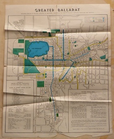 Ballarat Tramway Museum
Map, Greater Ballarat Association and George Netherway, "Map of Ballarat", c1950
... On rear is a road map of the Ballarat area, lists of statistics.... Includes the Lake Wendouree Rowing course On rear is a road map ...Yields information about Greater Ballarat, including trams, buses, locations and streets. Has a strong association with George Netherway.Four colour map of Ballarat, showing streets, places of interest, Parks, tram routes, bus routes, railway lines, prepared by G. C. Netherway, Greater Ballarat Association. Shows suburbs names, location of places of interest, some development north of Howitt St, in Wendouree. Map is part diagrammatic and is not entirely to scale. Includes the Lake Wendouree Rowing course On rear is a road map of the Ballarat area, lists of statistics, beauty spots, look outs, art and culture, points of historical interest, industrial products and recreation. Printed by Waller & Chester on paper produced by Ballarat Paper Mills Pty Ltd. See Reg item 2074 for photographic image of this version of the map. See Reg Item 2776 for another version of this map. Contained originally within Reg Item 5507 at the back of the binder. For items see btm5507 loose items list.pdf John Whiting in an email of 17-9-2021 noted: The rowing course along Lake Wendouree is noted, so perhaps this map is post 1956? The Mt Pleasant tram line is shown to terminate at Morton St, not Cobden St (which of course is incorrect) Someone's come along and drawn in black ink the branch of the View Point tram line!trams, tramways, ballarat, tram routes, bus routes, map, lists -
 Whitehorse Historical Society Inc.
Map - Parish Map, Parish of Nunawading, 1892
... . The map includes roads, railway, stations, names of property... and Boundary Road, Mulgrave to the north. Maps Parish of Nunawading ...A map copied from 'Directory maps - parishes and counties' dated 26 Nov 1892. Compiled and lithographed by G.S. Bonney. The map includes roads, railway, stations, names of property owners. It has a scale [ca. 1:31,680] 40 chains to an 1 inch.A map copied from 'Directory maps - parishes and counties' dated 26 Nov 1892. Compiled and lithographed by G.S. Bonney. The map includes roads, railway, stations, names of property owners. It has a scale [ca. 1:31,680] 40 chains to an 1 inch.non-fictionA map copied from 'Directory maps - parishes and counties' dated 26 Nov 1892. Compiled and lithographed by G.S. Bonney. The map includes roads, railway, stations, names of property owners. It has a scale [ca. 1:31,680] 40 chains to an 1 inch.maps, parish of nunawading -
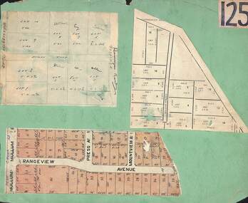 Ringwood and District Historical Society
Card, Collage of Residential Subdivision Map Clippings - Ringwood, Victoria - (Undated)
... Road Park Orchards. Map with acres roods and perches... Road Park Orchards. Map with acres roods and perches ...Three maps mounted on green cardboard - Hand-drawn map of residential allotments off Warrandyte Road in Milne Road and Berringa Road Park Orchards. Map with acres roods and perches measurements of allotments in Canterbury Road and Miller Street Heathmont. Clipping from a land sale brochure with street names not existing together in the area - Rangeview Avenue, Press Avenue and Mountview Avenue. -
Bendigo Historical Society Inc.
Map - CAMPBELL COLLECTION: BENDIGO & DISTRICT MAPS, 21-8-1972
... Map. Strathfieldsaye. Locality Plan, Scale 1 inch, also... Inc. History House 11 Mackenzie Street Bendigo goldfields MAP ...Map. Strathfieldsaye. Locality Plan, Scale 1 inch, also marked are : Shire of Huntly, Shire of McIvor, Shire of Metcalfe, Shire of Maldon, Shire of Marong, City of Bendigo, Lake Eppalock, and various lanes and roads. Mileage on some roads. (number 370 in map cupboard 1)M.Higgsmap, bendigo, rural -
Bendigo Historical Society Inc.
Map - MILLOO : COUNTY OF BENDIGO, 29-2-24
... Map. Milloo, County of Bendigo. Wanurf, Dingee, Kamarooka.... Price 1/-. Janiember to Rochester Road. (number 72 in map ...Map. Milloo, County of Bendigo. Wanurf, Dingee, Kamarooka, Pannoomilloo, Waranga Mallee Channel, Elmore to Kerang Road, Pannoo Estate. By authority A.J. Mullett, Govt. Printer. Photo-Lithographed at the Department of Lands and Survey, Melbourne, by W.J. Butson, 29-2-24. Price 1/-. Janiember to Rochester Road. (number 72 in map cupboard 1)A.J. Mullett, Government Printer.map, bendigo, milloo -
Glenelg Shire Council Cultural Collection
Booklet - Brochure - Promoting Portland, Victoria, Victorian Railways Print, Oct-38
... cover, black line map with roads marked in orange. Black... line map with roads marked in orange. Black and white photos ...Brochure promoting Portland, folds out to A3 printed on light card. Front cover, white and blue stylised sky with sea and a seabird. 'PORTLAND, VICTORIA, AUSTRALIA' -printed in red. Back cover, black line map with roads marked in orange. Black and white photos of harbour, Dutton Beach, Gardens cottage, Henty Beach, 'Burswood', Henty Memorial, plus printed information about Portland and district.portland -
 Bendigo Historical Society Inc.
Map - Bush Fire Control Map Bendigo District
... Cream coloured parchment map showing roads, railway lines... A Bush Fire Control map is a valuable tool used by emergency ...A Bush Fire Control map is a valuable tool used by emergency services and communities to respond to respond to bushfires.Cream coloured parchment map showing roads, railway lines, telephone lines, rivers, creeks and water courses. Also marked are houses, Post Offices, Police stations, bush fire brigades, water channels, swamps, marshes, dense, medium and scattered timber, aqueducts and reservoirs. Villages, districts and Towns are clearly marked. Printed in red, green, black and blue. Very clear and easy to read. Undated.bush fires, bendigo area map -
 Ballarat Tramway Museum
Pamphlet, Public Transport Corporation (PTC), "White Night Ballarat", Feb. 2017
... , transport map and road closures. Published by Visit Victoria...., transport map and road closures. Published by Visit Victoria. "White ...Set of two pamphlets distributed at the time for the "White Night Ballarat" Festival Saturday 4 March 2017. .1 - a grab rail pamphlet listing the bus services for the festival - piece of heavy card with a round top and a slit to enable it to be placed on a grab rail within the bus itself. .2 - 4 fold - DL sheet - titled "Give me the night" for the "White Night Ballarat" festival, with an map of the various events, messages of support, transport map and road closures. Published by Visit Victoria.trams, tramways, ballarat public transport, buses, ptv, public transport victoria, timetables, white night -
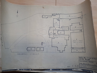 Vision Australia
Plan - Image, RVIB Maintenance drawing, April 1963 - November 1966
... by an architectural firm. These plans include: 1 - St Kilda Road Property...Vision Australia 454 Glenferrie Road Kooyong melbourne ...A series of maintenance drawings were made or copied by an architectural firm. These plans include: 1 - St Kilda Road Property - a site map of the buildings and grounds with the names of the various areas added. 2 - St Kilda Road Central Building (copied from a RAAF drawing) showing rooms on the ground floor. 3 - St Kilda Road Central Building (copied from a RAAF drawing) showing rooms on the first floor. 4 - St Kilda Road Central Building roof plan. 5 - St Kilda Road Factories showing the layout on the ground floor. 6 - St Kilda Road Factories showing the layout on the first floor. 7 - St Kilda Road building showing all three floors of the building rented out to Alfred Hospital. 8 - St Kilda Road caretaker, factory, fundraising and rehabilitation training buildings. 9 - Raleigh Street, Prahran hostel layout for both girls and boys.9 pages of plans of buildings on St Kilda road siteVarious - see individual plansmyer house, royal victorian institute for the blind, plans, raleigh street hostel, alfred hospital -
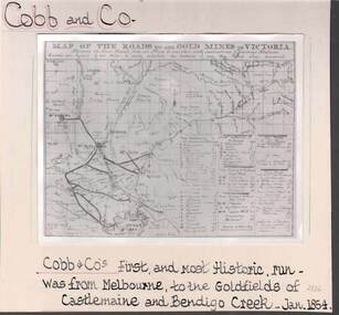 Bendigo Historical Society Inc.
Photograph - COBB & CO,., MAP OF COACH RUN TO BENDIGO
... map of roads to all gold mines in Victoria., showing Cobb & Co... and white image ( copy ) on board : image shows map of roads to all ...black and white image ( copy ) on board : image shows map of roads to all gold mines in Victoria., showing Cobb & Co., routes. Written on board: Cobb and Co., Cobb & Co's first and most historic run was from Melbourne to the goldfields of Castlemaine and Bendigo Creek, Jan 1854./// image shows -'Map of the roads to all gold mines in Victoria., showing the Cross roads from one mine to another with indications of various stations divided into squares of ten miles to easily calculate the distance of any new mines when discovered ///There is a list of towns with their distance from Melbourne and to & from distances for other destinations Cobb & Co., routesbusiness, transport, cobb & co., cobb & co., bendigo, transport -
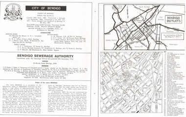 Bendigo Historical Society Inc.
Document - LONG GULLY HISTORY GROUP COLLECTION: CITY OF BENDIGO
... of the name Bendigo. There is a small map of Bendigo Outlet roads... of the name Bendigo. There is a small map of Bendigo Outlet roads ...Page with the titled City of Bendigo includes when the County was created, proclaimed a Borough, then a City and a name change, the area, population, swellings and Mayoral Allowance. Darling Ward Councillors were: Cr R L Campbell, The Mayor, Cr N C Jeffrey, and Cr J Pearce. Sutton Ward Councillors, Cr M Petersen, Cr R F Turner, and Cr C Stoltz. and Barkly Ward Councillors, Cr P T Tomkinson, Cr C Davies and Cr P Mansell. Bendigo Sewerage Authority Members: T R Flood, C Stoltz, P Tomkinson, R Campbell, R F Turner, A L Roy, K Houlahan, E Knight, J Bowles, M Brennan, H A Moors and V F Moyle. Also mentioned is the Origin of the name Bendigo. There is a small map of Bendigo Outlet roads and another map with services, attractions, churches, etc.bendigo, history, long gully history group, the long gully history group - city of bendigo, cr r l campbell, cr n c jeffrey, cr j pearce, cr m petersen, cr r f turner, cr c stoltz, cr p t tomkinson, cr c davies, bendigo disposals, cr p mansell, bendigo sewerage authority, t r flood, bendigo city council, a l roy, borough of eaglehawk, k houlahan, shire of strathfieldsaye, e knight, shire of marong, j bowles, shire of huntly, m brennan, h a moors, v f moyle, abednego, john wesley, abednego thompson, battling bendigo, richard sherratt, thomas myers, castleton, sandhurst, military college of sandhurst england -
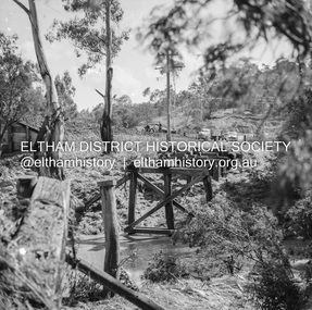 Eltham District Historical Society Inc
Negative - Photograph, J.A. McDonald, Eltham-Diamond Creek Road, 21 Sep 1959
... not exist and was merely a road reserve on the map. The bridge... not exist and was merely a road reserve on the map. The bridge ...Bridge construction Eltham-Diamond Creek road over the Diamond Creek (Wattletree Road), Eltham, September 1959 After some delay in receiving funds, work started on the bridge approaches in early September 1959. Traffic was still using the old bridge upstream. On Sunday, 20 September 1959, heavy flooding occurred in the stream and at 3:53 pm the old bridge was washed out. This photo was taken the day after. To the left is the Diamond Creek side abutment for the new Wattletree Road bridge under construction. Where the trucks are parked is near the present-day intersection with Progress Road. At the time Progress Road did not exist and was merely a road reserve on the map. The bridge was originally built as a replacement for an older private bridge built by a man named Foley around 1880. In 1911 Heidelberg and Eltham agreed to share the costs to build a new bridge. Construction began in June 1915 and it was officially opened by Cr. Taylor on Cup Day, November 1915.Record of various Shire of Eltham infrastructure works undertaken during the period of 1952-1962 involving bridge and road reconstruction projects, sometimes with Eltham Shire Council Project Reference numbers quoted. It was during this period that a number of significant improvements were made to roads and new bridges constructed within the shire that remain in place as of present day (2022). In many situations, the photos provide a tangible visible record of infrastructure that existed throughout the early days of the Shire. The album was put together by or under the direction of the Shire Engineer, J.A. McDonald.infrastructure, shire of eltham, bridge construction, bridge, diamond creek (creek), eltham, eltham north, glen park bridge, 1959-09-21, flood damage, wattletree road bridge -
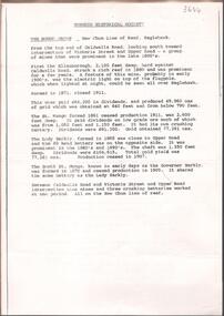 Bendigo Historical Society Inc.
Document - NEW CHUM LINE OF REEF MUNGO GROUP EAGLEHAWK
... . Victoria Street and Upper Road marked on the map. 'Between... Street and Upper Road marked on the map. 'Between Caldwells Road ...Two page document detailing the Mungo Group of Mines along the New Chum line of reef, Eaglehawk. The mines described are: Ellenborough, 2100 feet deep St Mungo, 2,600 feet deep The Lady Barkly, 1,350 feet deep, close to Upper Road with a 40 head battery on the other side. South St Mungo, known as the Governor Barkly in the earlier days. Small map on second page shows the location of the Sadowa shaft, St. Mungo shaft and the Lady Barkly shaft. Victoria Street and Upper Road marked on the map. 'Between Caldwells Road and Victoria Street and Upper Road intersection, nine mines and three crushing batteries worked at one period. All on the New Chum line of reef.' Not signed but most probably written by Albert Richardson.bendigo, mining, mungo group of mines, eaglehawk