Showing 124 items
matching sand dune
-
 Peterborough History Group
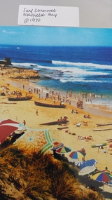
Photograph - Surf Carnival, Newfield Bay, Jocelyn Burt
... over the sand dunes. Spectators cars were parked in the area... the sand dunes. Spectators cars were parked in the area which ...Unusual choice of location by Port Campbell Surf club due to Port Campbell beach being too small. The Surf Carnival was held at Newfield Bay (possibly for two years running). Eyewitness accounts advise that one year the surf was so rough that the event was abandoned. This photograph appears to show calmer sea. In order to get the surf boats onto the beach a track was bulldozed over the sand dunes. Spectators cars were parked in the area which is now the airstrip, on the corner of the Port Campbell Peterborough Road and the Timboon Peterborough road.Town eventOriginal photograph of the surf carnival, taken from the west looking towards the east, with the Crown of thorns visible in the background. Surf boats are on the beach and umbrellas are visible. Occurred in the early 1970's.Written on the back is Jocelyn Burt, who is a photographer.newfield bay, surf lifesaving carnival, peterborough, jocelyn burt, crown of thorns rock formation -
 Orbost & District Historical Society
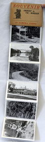
post cards, ca. 1945
... , Snowy River at Orbost, Marlo from the sand dunes, Prince's..., Snowy River at Orbost, Marlo from the sand dunes, Prince's ...This is a souvenir of Orbost from 1945.A set of 13 black and white postcards in a fold-out format. Pictures are of : Nicholson Street, Snowy Rriver flats from Grand View, avenue leading to Obost. Snowy River bridge at Orbost, Snowy River at Orbost, Marlo from the sand dunes, Prince's Highway at Victorian-NSW. border, Genoa River and bridge at Genoa, Prince's Highway at Mt. Drummer, Cann River hotel, fern scene, Euchre Valley, ponsasinorum near Cann River. SOUVENIR Orbost to Vic Border 13 camera viewspostcard souvenir photographs orbost cann-river -
 Lakes Entrance Historical Society
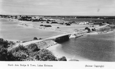
Postcard - Lakes Entrance from Jemmys Point, Bulmer H D, 1950c
... in Cunninghame Arm, and sand dunes. Caravan parked beside concrete brick... in Cunninghame Arm, and sand dunes. Caravan parked beside concrete brick ...Township of Lakes Entrance from Jemmys PointColour tinted postcard of township showing bridge across North Arm; town buildings including Club Hotel, Methodist Church, Maranui Guest House; tower of Central Hotel; jetties in Cunninghame Arm, and sand dunes. Caravan parked beside concrete brick constructed toilet block opposite road to Bullock Island. Footbridge across Cunninghame Arm in distance, also lookout tower on Esplanade, and Life Saving tower over hummocks. Lakes Entrance VictoriaNorth Arm Bridge and Town, Lakes Entrancetownship, jetties, guesthouses, islands, hotels -
 Lakes Entrance Historical Society
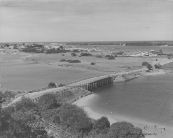
Postcard - Lakes Entrance 1945, 1945c
... and Club Hotel; jetties in Cunninghame Arm; sand dunes...; jetties in Cunninghame Arm; sand dunes; and concrete brick toilet ...North Arm Bridge and TownColour photograph of bridge across North Arm, showing town and Club Hotel; jetties in Cunninghame Arm; sand dunes; and concrete brick toilet block built beside Highway between Club Hotel and North Arm. Concrete brick toilet block opposite road to Bullock Island built after World War 2 bricks made on Kimmels Farm, toilet at Harbecks Wharf and cricket club pavilion built same era. Lakes Entrance Victoriatownship, hotels, bridges -
 Warrnambool and District Historical Society Inc.
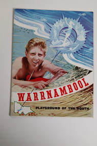
Document - Warrnambool Playground of the South Tourist Guide, Collett & Bain, 1959
... on the sand dunes, a small map of Victoria locating Warrnambool... an illustration of a young man on the sand dunes, a small map of Victoria ...A 1959 tourist guide showcasing Warrnambool attractions.This guide gives an insight into tourist attractions and facilities in Warrnambool in the late 1950'sThis 24page paper booklet contains colour and black and white photographs and text showcasing Warrnambool as a tourist destination. The front cover has an illustration of a young man on the sand dunes, a small map of Victoria locating Warrnambool in the bottom left hand corner and stylised tourist activities in the top right hand quadrant. The rear cover has a photograph of a woman in a swimsuit holding a green surf board surrounded by stylised tourist activities printed in red ink. There is a blue banner across the bottom of the rear cover.Front cover: Warrnambool Playground of the South Rear cover: A Warrnambool Holiday for Everyonewarrnambool, warrnambool tourist guide -
 Flagstaff Hill Maritime Museum and Village
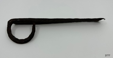
Functional object - Latch, before 1890
... is just inland from the sand dunes of the Coastal Reserve at Tower... Lane is just inland from the sand dunes of the Coastal Reserve ...In Flagstaff Hill’s collection are items associated with the Ancient Wreck, (also called the Gold Ship, Mahogany Ship or Ancient Vessel). Three relics were located in 1890, due to the ‘interest of a public works inspector, James Gilroy, who dug in the ship’s remains’. One of the relics was a heavily oxidated ‘quantity of ironwork’. The other two, now part of Flagstaff Hill’s collection, are - an iron latch probably from a galley oven door or fireplace - a bronze bolt (spike or pin) Both of these relics are listed on the same page in the records of the Old Warrnambool Museum, found by K.A.G. (or H.A.G.) on the site of the Ancient wreck in 1890. Interestingly, another item in these records is ‘Notes on Ancient wreck, near Gorman’s Lane’. Gorman’s Lane is just inland from the sand dunes of the Coastal Reserve at Tower Hill. The current location of these Notes is unknown. Another item thought to be a relic from the Mahogany Ship was the amphora or jug, also in Flagstaff Hill's collection. It was found in 1934 on a local property and donated in 1985. The Museum opened in 1886 and continued until 1963, when it was closed by the Warrnambool City Council and the whole collection was put into storage. The council then transferred items to various places including Flagstaff Hill and the current Warrnambool Art Gallery. Flagstaff Hill’s early Accession Records book lists the items as being received from the Old Warrnambool Museum collection; the Latch is record 152 and the Pin is record 153. An article, ‘Birthplace of our History’ by Don Dean, is on file in the Warrnambool and District Historical Society. It was published in the Australian POST, on March 17, 1955. This article describes the finding of the items going back to 1890, along with other information about sightings of what has come to be known as the Mahogany Ship. The mystery of the Mahogany Ship began in 1836 when two shipwrecked sealers discovered the remains of an “ancient vessel” in the sand dunes about four miles west of Warrnambool. Since the last recorded sightings in the 1880’s the true origin of the Mahogany Ship has remained one of Australia’s most famous historical mysteries. One of the more recent theories is that the vessel was one of the Portuguese ships exploring the Australian coast in 1522. For over one hundred years searchers have attempted to locate and identify the wreck. The search continues for the tangible evidence which will once and for all establish the Mahogany Ship’s place in Australia’s History. The latch has local historic significance as it was found in the sand dunes of Warrnambool in 1890. The latch is also significant for being part of the original 1886 Warrnambool Museum's collection. The latch is significant for its possible link to one of Victoria’s and Australia’s maritime mysteries, the Mahogany Ship (also known as the Ancient Wreck). It is one of very few known relics that could give evidence of the existence and history of the vessel. It is listed on the Victorian Heritage Register S438 as it is one of Victoria’s oldest recorded shipwrecks. The identity of the vessel has the potential to change Australia’s history.Latch, iron. Flat iron latch tapers inward from loop handle to narrow end with prongs. Handmade. warrnambool, shipwrecked coast, flagstaff hill maritime museum, shipwreck coast, mahogany ship, latch, relic, old warrnambool museum, ancient vessel, ancient wreck, oven latch, fireplace latch, galley oven, gold ship, gorman's lane, coastal reserve, tower hill -
 Flagstaff Hill Maritime Museum and Village
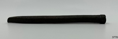
Functional object - Bolt, before 1890
... Lane is just inland from the sand dunes of the Coastal Reserve... Lane is just inland from the sand dunes of the Coastal Reserve ...Flagstaff Hill’s collection has items that are thought to be relics from the Ancient Wreck, (also called the Gold Ship, Mahogany Ship or Ancient Vessel). Three relics were located in 1890, due to the ‘interest of a public works inspector, James Gilroy, who dug in the ship’s remains’. One of the relics was a heavily oxidated ‘quantity of ironwork’. The other two, now part of Flagstaff Hill’s collection, are - an iron latch probably from a galley oven door or fireplace - a bronze bolt (spike or pin) Both of these relics are listed on the same page in the records of the Old Warrnambool Museum, found by K.A.G. (or H.A.G.) on the site of the Ancient wreck 1890. Interestingly, another item in these records is ‘Notes on Ancient wreck, near Gorman’s Lane’. Gorman’s Lane is just inland from the sand dunes of the Coastal Reserve at Tower Hill. The current location of these Notes is unknown. Another relic is thought to be the amphora, discovered in 1934 on a local property. The Museum opened in 1886 and continued until 1963, when it was closed by the Warrnambool City Council and the whole collection was put into storage. The council then transferred items to various places including Flagstaff Hill and the current Warrnambool Art Gallery. Flagstaff Hill’s early Accession Records book lists the items as being received from the Old Warrnambool Museum collection; the Latch is record 152 and the Pin is record 153. An article, ‘Birthplace of our History’ by Don Dean, is on file in the Warrnambool and District Historical Society. It was published in the Australian POST, March 17, 1955. This article describes the finding of the items going back to 1890, along with other information about sightings of what has come to be known as the Mahogany Ship. The mystery of the Mahogany Ship began in 1836 when two shipwrecked sealers discovered the remains of an “ancient vessel” in the sand dunes about four miles west of Warrnambool. Since the last recorded sightings in the 1880’s the true origin of the Mahogany Ship has remained one of Australia’s most famous historical mysteries. One of the more recent theories is that the vessel was one of the Portuguese ships exploring the Australian coast in 1522. For over one hundred years searchers have attempted to locate and identify the wreck. The search continues for the tangible evidence which will once and for all establish the Mahogany Ship’s place in Australia’s History. The bolt has local historic significance as it was found in the sand dunes of Warrnambool in 1890. The bolt is also significant for being part of the original 1886 Warrnambool Museum's collection. The bolt is significant for its possible link to one of Victoria’s and Australia’s maritime mysteries, the Mahogany Ship (also known as the Ancient Wreck). It is one of very few known relics that could give evidence of the existence and history of the vessel. It is listed on the Victorian Heritage Register S438 as it is one of Victoria’s oldest recorded shipwrecks. The identity of the vessel has the potential to change Australia’s history.Bolt, also referred to as spike or pin. Bronze bolt, round body with head on one end that has straight sides, tapers to a point at the other end.warrnambool, shipwrecked coast, flagstaff hill maritime museum, shipwreck coast, mahogany ship, relic, pin, spike, old warrnambool museum, nail, ancient vessel, ancient wreck, portuguese ship, gold ship, gorman’s lane, coastal reserve, tower hill -
 Flagstaff Hill Maritime Museum and Village
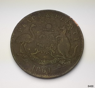
Currency - Coin, Robert Hyde & Co. Shipping Merchants, 1861
... token coin in the sand dunes of Lady Bay, Warrnambool, in 2023....) of this coin found this penny token coin in the sand dunes of Lady Bay ...The donor (a local resident.) of this coin found this penny token coin in the sand dunes of Lady Bay, Warrnambool, in 2023. The coin could have come from a local shipwreck, passengers, or members of the community. Trade was carried out along the southwest coast of Victoria between Melbourne and Portland, with the Port of Warrnambool receiving passengers and goods by coastal traders, the steamboat that set off from ports every few days. One such vessel was the steamship SS Edina that made her first voyage from Melbourne to Portland in 1863. For around a decade or so in the Gold Rush period in Australia there was a shortage of official government currency. It was acceptable during this time to use token coins minted by local businesses to be used within their store, much like the loyalty and rewards cards that businesses give their customers in modern times. The tokens were also a good way to advertise their wares and details. The first token was introduced in Melbourne in 1848 and were used until 1868, when they became illegal in New South Wales. They were minted in Australia and overseas. The token was issued by Robert Hyde & Co. who traded in second-hand goods such as old clothes, sheets, metal items and glass, which they resold to be re-manufactured, or "recycled".A token such as this one identifies businesses existing in the post-Gold Rush period in Australia. Round copper coin. Penny token coin bearing the Australian Coat of Arms and motto. The coin also has the company's name, location, nature of business and motto. The coin has grooves around the edge. It was made in 1861.OBVERSE: Logo: (Australian Coat of Arms), Motto: "PEACE & PLENTY", Date: 1861 REVERSE: "ROBERT HYDE & CO MELBOURNE", "GENERAL MARINE STORE, SHIPPERS OF RAGS GLASS METALS &.C"flagstaff hill maritime museum and village, warrnambool, great ocean road, shipwreck coast, merchant token, melbourne, token, australian token, trade token, coins, merchants, medal, colonisation, gold rush, robert hyde & co., general marine store, shippers of rags glass metals etc., numismatics, second-hand scrap, scrap goods -
 Flagstaff Hill Maritime Museum and Village
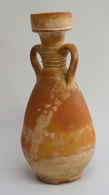
Ceramic - Amphora, mid-to-late 1800s
... . The presence of the amphora in the sand dunes, and the amphora itself... was discovered by Joe O'Keeffe in 1934 in a sand blowout west of Levy's ...This amphora or jug, with a silhouette shaped like a woman with hands on hips wearing a long flared-out skirt. The design was used in ancient Greece for pottery storage jars, the neck being narrower than the body. The amphora was discovered by Joe O'Keeffe in 1934 in a sand blowout west of Levy's Point west of Warrnambool while he was planting marram grass for Mr Duncan. An article in the Warrnambool Standard newspaper of December 21, 1985, states that the amphora may be linked to the wooden sailing ship called the Mahogany Ship (also called the Ancient Wreck). Thermoluminescence testing indicates the relic was made in the mid-to-late 1800s and experts suggest it was of North African origin. The presence of the amphora in the sand dunes, and the amphora itself, are still a mystery. The amphora was donated to Flagstaff Hill on a long-term loan by the Duncan family and displayed to the public for the first time on December 21, 1985, until February 2023 when the display was returned to storage to rest with the redevelopment of the Assistant Lighthouse Keepers Cottage (Shipwreck Museum). An extensive search for members of the Duncan Family has been undertaken by Flagstaff Hill and stakeholders to resolve the loan term loan, but the family is not known. As such to properly care for the amphora, it has been registered until ownership can be determined.The object is significant for its possible link to one of Victoria’s and Australia’s maritime mysteries, the Mahogany Ship (also known as the Ancient Wreck). It is one of very few known relics that could give evidence of the existence and history of the vessel. It is listed on the Victorian Heritage Register S438 as it is one of Victoria’s oldest recorded shipwrecks. The identity of the vessel has the potential to change Australia’s history.Amphora or jug; earthenware, orange clay with areas of cream. The vessel has a wide mouth, a deep lip, two opposing handles between the neck and shoulder, and a bulbous body. The curved handles have a design of six bands between them. There are three rings of small dots encircling the body. The underside has concentric circles in the clay, uneven edge and pinhole markings. Pinhole patterns: [3 holes above 3 holes] opposite [3 holes above 3 holes], 1 hole] [ 1 hole above 2 holes]flagstaff hill maritime museum and village, warrnambool, great ocean road, shipwreck coast, amphora, jug, mahogany ship, ancient wreck, joe o'keefe, duncan, thermoluminescence, north africa, levy point, pottery, storage jar -
 Phillip Island and District Historical Society Inc.
Photograph - Photographs of Phillip Island, 1920s and 1940s
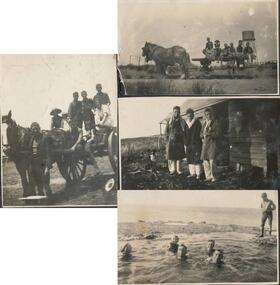
... of 3 women and 1 girl sitting on sand dunes. 314-08... and 1 girl sitting on sand dunes. 314-08. Photograph of 3 boys ...Photographs associated with Public Schools camp, that started in the 1930s. Some boys worked on chicory at McFee's farm. 314-05 was possibly located at Trenavin Farm, Ventnor. (Source Jan Andrews ) Photo of people on cart with tank stand was off to a 7 picnic at the Nobbies 1917. [See 1124-01] Keeston Sambell driving, behind him is Betty Parker. on side from left is May Lambert, Jim Patterson, Jim Blake, Carmen Sambell and Bill Sambell.[ Source Jim Blake] Eight black & white photographs. 314-01. Photograph of horse and cart with 2 women, 2 girls and 5 boys. 314-02. Photograph of a mixed group of 7 people on a horse and drag. 314-03. Photograph of 3 young adult males and a dog standing in front of a wooden building. 1926 “Campers Rest” Labelled The Immortal camp at Ventnor. Poss. Trenavin Park 314-04. Photograph of 5 boys and 1 woman swimming in rock pool. 1 boy watching. 314-05. Photograph of old wooden hut with tank and chimney. Appears to have been used by boys when camping. 314-06. Photograph of 4 boys - 2 in swimming costumes - on the beach. 314-07. Photograph of 3 women and 1 girl sitting on sand dunes. 314-08. Photograph of 3 boys in uniform and 1 man sitting on bench - maybe watching sporting event?scotch college camp phillip island, scotch college boys, s j mcfee, c.k. newman, f. r. newman, trenavin park phillip island, sambell family, jim blake, betty parker -
 Lakes Entrance Historical Society
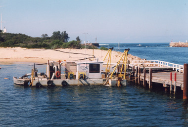
Photograph, Sand Dredge Lakes Entrance Victoria
... across sand. Scrub on dune, flagstaff and weather station on dune... on beach showing pipe line from dredge across sand. Scrub on dune ...Colour photograph of transfer pump moored to north end of Eastern Pier. Dredged sand on beach showing pipe line from dredge across sand. Scrub on dune, flagstaff and weather station on dune - top left. Entrance and tip of western pier top right. Lakes Entrance Victoriaboats and boating, dredging, beaches -
 Lakes Entrance Historical Society
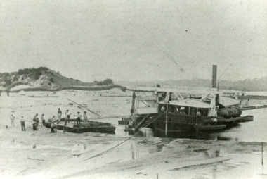
Photograph - Wombat, 1885c
... removing sand from between piers. Dunes on western side on left... and white photograph showing bucket dredge Wombat removing sand from ...The dredge 'Wombat' owned by John Carpenter, contractor for stage one of cutting the entrance from the lake through to ocean - Bass Strait. Photo shows channel partly dredged and men on work platform in front of dredge.Black and white photograph showing bucket dredge Wombat removing sand from between piers. Dunes on western side on left, lakes in background, hills of Kalimna and Nungurner in distance. Work platform in front of dredge with workers. Lakes Entrance Victoria waterways, public works, dredging -
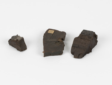 The Beechworth Burke Museum
Geological specimen - Coorongite
... and sand dunes which extend for a considerable distance east... and sand dunes which extend for a considerable distance east ...Coorongite is a dark, rubber-like, highly resilient structureless algal deposit. In the Coorong district of South Australia it occurs in moderate quantities associated with the coastal swamps and sand dunes which extend for a considerable distance east of the mouth of the Murray. This particular specimen was recovered from the south of the Coorong River, South Australia. A type of sediment rich in organic matter, Coorongite is the unlithified end-member of the sapropelic coal series. The members of the sapropelic coal series can be ranked in order as sapropel (the unlithified form), sapropelic-lignite, and sapropelic-coal (the lithified forms) based on increasing carbon content and decreasing volatile content. Sapropel (Coorongite) is an unlithified dark, pulpy, fine organic mud containing concentrations of algae and miospores that are more or less identifiable. Coorongite is typically found as an algae like substance, that can be found in irregular size pieces. Coorongite was believed to be dried up oil due to its rubber-like texture. The Coorongite is also soft to the point where it can be cut into with a knife or it can be broken and torn by hand. Otherwise known as 'Kurangk', the Coorong River is home to the Ngarrindjeri people, which acts as both a place for gathering food and a spiritual place. In 1852 the first sight of Coorongite was found along the Coorong River. The finders mistook the Coorongite for dried up oil, which lead to the belief that there were oil reserves under the Coorong River. Between the 1860s and the 1930s the Coorong River became a place where mining oil and Coorongite became precedent. Nowadays, the local council and the South Australian Government are working together with the Ngarrindjeri people to sustain and preserve the Coorong River and the culture that is with it. Soon after gold was discovered in 1851, Victoria’s Governor La Trobe wrote to the Colonial Office in London, urging ‘the propriety of selecting and appointing as Mineral Surveyor for this Colony a gentleman possessed of the requisite qualifications and acquaintance with geological science and phenomena’. Alfred Selwyn was appointed geological surveyor in Australia in 1852 which began the Geological Survey of Victoria. Selwyn went on to collect geological samples and catalogue thousands of specimens around Australia. In 1853-69 the Geological Survey issued under Selwyn's direction sixty-one geological maps and numerous reports; they were of such high standard that a writer in the Quarterly Journal of the Geological Society of London bracketed the survey with that of the United States of America as the best in the world. During his years spent in Australia, Selwyn collected numerous significant geological specimens, examples of which are held in collections such as the Burke Museum.Coorongite is considered to be a mineral with a unique texture, where it can be both hard and soft. Coorongite can also be considered to be a rare mineral, as it is only located along the Coorong River and due to the mining of it, has left very few sources. It was believed at one point that Coorongite could be used to replace oil. This specimen is part of a larger collection of geological and mineral specimens collected from around Australia (and some parts of the world) and donated to the Burke Museum between 1868-1880. A large percentage of these specimens were collected in Victoria as part of the Geological Survey of Victoria that begun in 1852 (in response to the Gold Rush) to study and map the geology of Victoria. Collecting geological specimens was an important part of mapping and understanding the scientific makeup of the earth. Many of these specimens were sent to research and collecting organisations across Australia, including the Burke Museum, to educate and encourage further study.Three solid varyingly hand-sized pieces of wooden appearing organic matter derived from the river in the Coorong District in South Australia. A rubber-like, highly resilient structureless algal deposit.Specimen 245 page 69 / in Descriptive Register / "Elcestic Bitumen, / Coorangite" South of / Coorung River, South Australia . / C. WIllman / 15/4/21burke museum, beechwoth, indigo shire, beechworth museum, geological, geological specimen, mineraology, coorong, coorong river, kurangk, ngarrindjeri, south australia, coorongite, coorongite specimen -
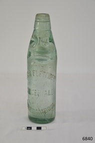 Flagstaff Hill Maritime Museum and Village
Container - Bottle, c. 1905
... . It was found in August 2014 in the sand dunes at Levy's Point, near... Fletcher’s ginger cordial. It was found in August 2014 in the sand ...This bottle once contained John Fletcher’s ginger cordial. It was found in August 2014 in the sand dunes at Levy's Point, near McKinnon's quarry, Warrnambool. ABOUT JOHN FLETCHER of WARRNAMBOOL John Fletcher Cordial (or Beverage) Co . Warrnambool, supplied cordial and aerated drinks to the Western district of Victoria. John Fletcher was named as a cordial manufacturer in the Warrnambool Standard of June 13th 1895, when he attended a Publican’s Association meeting. Mr John Fletcher, aerated water and cordial manufacturer of Koroit Street Warrnambool, had a summary of his factory printed in a short article in the Advocate, Melbourne, in February 1901. The article said “one of the most complete plants outside the metropolis … spacious … well appointed …old-established business … noted for the excellence of the quality … a trial [of the beverage] is solicited.” John Fletcher and Harold Caffin, trading as J.S. Rowley & co cordial manufacturers in 1903; were prosecuted in September 1903 when the Board of Health found an analysed sample of Raspberry Vinegar to contain coal tar colouring, which could be injurious to health, particularly to the kidneys. The factory was still in operation in December 1924, when sadly, Mr S. Fletcher, who was carrying bottles of aerated water at Mr John Fletcher’s cordial factory, sustained an eye injury when one of the bottles burst. Later the eye had to be removed at the Warrnambool Base Hospital. ABOUT CODD BOTTLES During the mid-to-late 1800s there were many inventions to keep the fizz in carbonated drinks such as ginger ale, soda water and fruit drinks. Hiram Codd, an English engineer invented a successful process that he patented as “Codd’s patented globe stopper bottle” in 1872. The Codd-neck bottle (commonly called Codd or marble bottle) is manufactured in two parts. The body of the bottle is cast in two sections. At the time of joining the sections a glass marble and rubber seal are inserted into the neck section. The lip is then applied to the top of the bottle. The Codd bottle is filled upside down as the pressure of the gas from the carbonated liquid holds the marble up and out of the way. When the bottle stands upright the gas pushes the marble up against the washer, creating a firm seal to keep the fizz inside. The bottle is opened by pushing the marble down firmly to allow some of the gas to escape. The marble drops down and is caught in a depression formed in the neck. When the bottle is tilted to pour or drink the liquid the marble rests in a dimple. Some have said that the bottle as a character, the shape having a face with its mouth keeping the marble out of the drink and eyes that catch the marble so that it doesn’t roll into the mouth of the drinker. The Codd bottle was expensive to produce and children loved to destroy the marbles to play with the marbles inside. Many shops and factories added a deposit to the cost of buying the drink to encourage children to return the bottles rather than break it for the marble. Codd bottles are still being produced in India and Japan for soft drinks. A Codd bottle with the same markings as this one is valued on today’s Australian auction sites from $35 - $75 AUD. Bottle, aqua/green glass, with glass marble inside. John Fletcher's Ginger Ale, Warrnambool. Container is often called a "Codd neck bottle", “marble bottle” or “Codd’s patent bottle”. Bottle made by Dobson. Inscription on bottle and base. c. 1905Marks moulded into glass; "JOHN FLETCHER / GINGER ALE / WARRNAMBOOL" and “DOBSON” and on base “G”. flagstaff hill, warrnambool, shipwrecked coast, flagstaff hill maritime museum, maritime museum, shipwreck coast, flagstaff hill maritime village, great ocean road, codd bottle, codd neck bottle, marble bottle, ginger beer bottle, john fletcher soft drinks, warrnambool soft drinks and cordials, john fletcher cordial (or beverage) co ., codd neck bottle, glass stopper bottle, hiram codd, antique bottle, harold caffin, john fletcher -
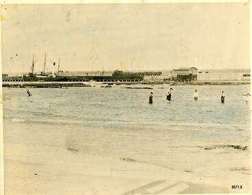 Flagstaff Hill Maritime Museum and Village
Photograph - Vessel S. S. Casino in Lady Bay Warrnambool, 1920's - 1930's
... to the beach, planting marram grass on the sand dunes, building new... to the beach, planting marram grass on the sand dunes, building new ...This photograph was one of ten photographs donated to Flagstaff Hill Maritime Museum and Village by Fred Trewartha. Frederick John Fox Trewartha (Fred) was a well-known Warrnambool businessman. He was born in Beeac near Geelong in 1920 and came to Warrnambool with his family as a very young child. He was apprenticed to his father John, as a saddler and later opened his own shop on Raglan Parade. He then moved into working with tarpaulins and canvases for the trucking industry. Fred was keenly interested in photography (and was a member of the Warrnambool Cine Club), yachting and boat building. He kept his yacht moored at Port Fairy for many years and participated in sailing events locally and interstate. He also built boats with his sons. He had the opportunity to meet many older sailors and it's thought this photo (and others in the set) may have been given to him by one of these men. Fred Trewartha died in 2016 in Warrnambool. Warrnambool by the 1920's and 1930's had become a popular holiday destination with visitors arriving by steamer and train. It was during these decades that a "Surf Bathers Association" began in Warrnambool in response to the growing popularity of local sea bathing. They worked with the local council to develop a "Beach Improvement Fund" and a comprehensive plan of "Beach Improvement" which included erecting and maintaining beach boxes, building a kiosk, improving paths and roads to the beach, planting marram grass on the sand dunes, building new enclosures for vehicles and horses and generally making the beach more attractive for visitors and townspeople. The 1930's was also an era when free "Herald" Learn-to-Swim classes were being held throughout Victoria. In 1931 it was reported in "The Age" newspaper that "over the past week in Warrnambool, 250 pupils had passed through the hands of the local life saving club swimming instructors". The Port of Warrnambool - In the early years the Port of Warrnambool was a busy port. Steamships and sailing ships were frequent visitors to the port. Steam navigation companies were plentiful, carrying passengers and freighting cargo such as coal, timber, food, livestock, furniture, hardware and haberdashery between Melbourne and the ports along the southwest coast of Victoria, including Warrnambool. The carts would take their loads into the township for distribution. The Breakwater was built (using 32 ton blocks of concrete) between 1874 and 1890 to provide ships with greater protection from the Southern Ocean. The Lifeboat and Rocket House - The coastline of South West Victoria has had over 600 shipwrecks and many lost lives; even in Warrnambool’s Lady Bay there were around 16 known shipwrecks between 1850 and 1905, with eight lives lost. In 1859 the first Government-built lifeboat arrived at Warrnambool Harbour and a shed was soon built to house it, followed in 1864 by a rocket house to safely store the Rocket Rescue equipment. In 1878 the buildings were moved to the Breakwater area, and in 1910 the new Lifeboat Warrnambool arrived with its ‘self-righting’ design. For almost one hundred years the lifeboat and rocket crews, mostly local volunteers, trained regularly to maintain and improve their skills, summoned when needed by alarms, gunshots, ringing bells and foghorns. Some became local heroes but all served an important role. By the end of the 1950s the lifeboat and rescue equipment had become obsolete. The S.S. Casino was a passenger and freight steamer built in Dundee, Scotland, in 1882 for the Newcastle and Hunter River Steam Navigation Company of N.S.W. She weighed 425 tons gross with a length of 160.4 feet, beam of 24.1 feet and a depth of 10.2 feet. She had saloon accommodation for 35 people, a fore cabin for 25 more people, and she carried 300 tons of cargo. While on her delivery journey on May 30th 1882, the S.S. Casino called in at the Port of Warrnambool for coal, narrowly escaping going ashore in gale force winds due to the quick action of the pilot. At that time, still at anchor, she impressed the directors of the Belfast and Koroit Steam Navigation Company so much that they bought her immediately; she was ideal for trade along the West Coast of Victoria. (The Belfast and Koroit Steam Navigation Company was first managed by Messers. Saltau and Osburne and after the passing of Mr. Osburne, by produce merchants Messers H. Sautau and Sons, who had a hay and corn store and shipping agency on the corner of Liebig and Koroit Streets in Warrnambool. ) The S.S. Casino became “the most famous steamer to operate in Victorian waters along the West Coast” by author Jack Loney. Captain Boyd was her first Master, followed by Captain Chapman, who stayed with her from 1890 until 1924. Captain W. Robertson followed for a short term, and then Captain Middleton then took command from 1925 - 1932. An article published on Monday 11th June 1932 in The Sun News Pictorial (Melbourne) giving a detailed history of S. S. Casino said "owned by Port Fairy interests, she was an integral part of the town's development ... for a long time, her arrival in Port Fairy was an event, the townspeople going down to the wharf to see her come in". It also said "Except when the weather was bad, the Casino hugged the coast on her trips and passengers obtained wonderful views of the sandstone terraces and caves. A little time ago every member of her regular crew except one, was a Scotsman." The S.S. Casino had several mishaps during her life. One was on 3rd January 1898 when she collided with the S.S. Flinders in Apollo Bay with minor damage. Another was on 24th October 1924 when she grounded on a reef at Point Hawdon near Grey River and most of her cargo (of Christmas goods) had to be dumped into the sea. Then in February 1929 she was ‘holed’ when she struck a submerged object as she entered Lady Bay, Warrnambool. In the years following the turn of the century, the S.S. Casino remained the only regular trader with normal passenger accommodation along the West Coast. From 1882 she had made at least 2,500 voyages on the one run. On the morning of 10th July 1932, after attempting to berth at Apollo Bay jetty in heavy seas, Captain Middleton decided to take her out into the bay and wait until the seas abated. It was not realised that the anchor used to steady her as she manoeuvred to her berth had pierced her hull. She put about and headed for the beach but sank. Captain Middleton and nine others lost their lives; nine people were rescued including the two female passengers. Captain Middleton had been in charge of the S.S. Casino for seven years. He was the first ship’s Master to lose his life in a shipwreck in the West Coast trade. In June 1932, the directors of the Belfast and Koroit Steam Navigation Company had proposed to celebrate the completion of fifty years of trading by the steamer Casino in August, but tragically the Casino was wrecked only one month later (and "was only one month off completing its fifty years of valuable service between Melbourne and Portland.") Flagstaff Hill’s collection has a photograph of a portrait of Captain Chapman, a ship model of the S.S. Casino that shows both forms of power under which she sailed, steam and sail. The ship is painted green and flies three flags. The inscription across the case of the ship model, incorrectly dated, tells the sad story of the wreck of the ship and the loss of lives on July 10th 1932 at Apollo Bay. A print in the Collection shows S.S. Casino underway in the heavy sea off Point Lonsdale, another two photographs show her at the Port of Warrnambool, leaving from the Breakwater in Lady Bay and another identifies the S.S. Casino as a ship from the Belfast and Koroit Steam Navigation Company. (Belfast is the original name for the township of Port Fairy).This photograph is significant because of its association with the coastal trader S.S. Casino and its significance to trade along Victoria's West Coast in the late 19th and early 20th centuries. The wreck of the S.S. Casino is considered an important part of Victorian and Australian cultural heritage and as such has been declared and protected as an Historic Shipwreck under State and Commonwealth Law in the Commonwealth Historic Shipwrecks Act (1976). It is also significant as it shows the early years of tourism in Warrnambool and the important role the beach played in the lives of residents and visitors.A black and white photograph (with colour tinting) showing Lady Bay in Warrnambool with the Breakwater in the background. The S. S. Casino is moored at the Breakwater and the lifeboat shed and a coal train can be seen on the Breakwater. Six swimmers are standing in the water. On the back of the photograph are the donor's name and telephone number (written in black biro) and the name of the S. S. Casino and its tonnage written in blue ink. A blurred number has been stamped on plus a "M' written in pencil.Donor's name, address and phone number / "S. S. Casino" / "500 TONS" / "REG" "- - - 09 " (blurred numbers) / "M"warrnambool, great ocean road, shipwreck coast, lady bay, breakwater, fred trewartha, frederick john fox trewartha, surf bathers association, sea bathing, swimming, warrnambool beach, beach improvement fund, port of warrnambool, steamships, lifeboat house, rocket house, lifeboat crew, s. s. casino, belfast and koroit steam navigation company, saltau and osburne, captain middleton, apollo bay, apollo bay shipwreck -
 Phillip Island and District Historical Society Inc.
Photograph
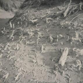
... & white photograph coastline cape woolamai sand dunes Dr A B ...One of a collection of over 400 photographs in an album commenced in 1960 and presented to the Phillip Island & Westernport Historical Society by the Shire of Phillip IslandPhotograph of Marram Grass plantings in the dunes at Woolamai Promontorylocal history, photography, dunes at cape woolamai, black & white photograph, coastline, cape woolamai, sand dunes, dr a b edwards, john jenner, bryant west -
 Phillip Island and District Historical Society Inc.
Photograph
One of a collection of over 400 photographs in an album commenced in 1960 and presented to the Phillip Island & Westernport Historical Society by the Shire of Phillip IslandPhotograph of calcareous moulds formed by early forms of vegetation and subsequent action of wind and sand.local history, photography, calcareous moulds, black & white photograph, coastline, dunes, john jenner, bryant west -
 Federation University Historical Collection
Report, Environmental/Physical Plan for Sorrento/Portsea Tourism Development, 1993
... victorian tourisim industry tourism sorrento portsea sand dunes ...Report compiled by five students of Tourism at University of Ballarat (later Federation University Australia)victorian tourisim industry, tourism, sorrento, portsea, sand dunes, clifftops -
 Monbulk RSL Sub Branch
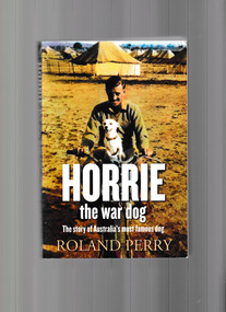
Book, Allen and Unwin, Horrie the War Dog, 2013
... Australian Machine Gun Battalion, found a starving puppy on a sand ...In the harsh Libyan desert in the middle of the second world war, Private Jim Moody, a signaller with the First Australian Machine Gun Battalion, found a starving puppy on a sand dune. Moody called the dog Horrie. Much more than a mascot, Horrie's exceptional hearing picked up the whine of enemy aircraft two minutes before his human counterparts and repeatedly saved the lives of the thousand-strong contingent. The little Egyptian Terrier's ritual of sitting, barking, then dashing for the trenches, had the gunners running for cover before their camp was strafed and bombed. Where Moody went, Horrie went too, through the battle zones of the Middle East and far beyond. As the Japanese forces began their assault in Asia Moody and his soldier mates joined the fight, but not before they had smuggled Horrie onto a troop ship and a harrowing journey back to Australia where they thought their little friend would be safe. The war over, Moody brought Horrie out of hiding to raise money for the Red Cross, and the brave little dog's story became widely known. When quarantine officers pounced and demanded that the dog be put down there was a huge public outcry. Horrie had saved a thousand lives. How could a cruel bureaucracy heartlessly kill him? But defying the authorities would mean gaol for Moody and certain death for Horrie. Was Horrie, the gunner's hero, condemned to die or could Moody devise a scheme to save him?Ill, p.336.non-fictionIn the harsh Libyan desert in the middle of the second world war, Private Jim Moody, a signaller with the First Australian Machine Gun Battalion, found a starving puppy on a sand dune. Moody called the dog Horrie. Much more than a mascot, Horrie's exceptional hearing picked up the whine of enemy aircraft two minutes before his human counterparts and repeatedly saved the lives of the thousand-strong contingent. The little Egyptian Terrier's ritual of sitting, barking, then dashing for the trenches, had the gunners running for cover before their camp was strafed and bombed. Where Moody went, Horrie went too, through the battle zones of the Middle East and far beyond. As the Japanese forces began their assault in Asia Moody and his soldier mates joined the fight, but not before they had smuggled Horrie onto a troop ship and a harrowing journey back to Australia where they thought their little friend would be safe. The war over, Moody brought Horrie out of hiding to raise money for the Red Cross, and the brave little dog's story became widely known. When quarantine officers pounced and demanded that the dog be put down there was a huge public outcry. Horrie had saved a thousand lives. How could a cruel bureaucracy heartlessly kill him? But defying the authorities would mean gaol for Moody and certain death for Horrie. Was Horrie, the gunner's hero, condemned to die or could Moody devise a scheme to save him? animals - war use, australia - armed forces - mascots -
 Koorie Heritage Trust
Book, Breidahl, Harry, A guide to Point Nepean's past, 1992
... Nepean-Kooris-history Contents: Ice ages & sand dunes; Koories ...Contents: Ice ages & sand dunes; Koories & the Great Flood; European Settlers; Limeburning; Ships & Shipwrecks; Fear of fever; The quarantine station; Protecting the Colony; Point Nepean Forts; Manning the Forts; Guns that disappeared; Mark VII Guns; First Shots; Exploring Point Nepean.32 p. : ill. ; maps; 17 x 24 cm.Contents: Ice ages & sand dunes; Koories & the Great Flood; European Settlers; Limeburning; Ships & Shipwrecks; Fear of fever; The quarantine station; Protecting the Colony; Point Nepean Forts; Manning the Forts; Guns that disappeared; Mark VII Guns; First Shots; Exploring Point Nepean.point nepean-history, point nepean-kooris-history -
Lakes Entrance Historical Society
Photograph, Eastwood Bros, 1889c
Sepia photograph showing the just opened Entrance to Bass Strait. Sand not completely cleared from channel, buildings on dunes, dredge Wombat moored off Bullock Island. Rock groynes being built in lake. Lakes Entrance Victoriawaterways, islands, jetties, houses -
 Port Fairy Historical Society Museum and Archives
Photograph
East beach car park and sandColoured photograph of Expanse of East Beach from the car park people playing on sandeast beach, car park, sandcastle, caras, dune -
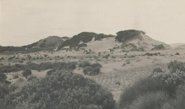
 Port Fairy Historical Society Museum and Archives
Photograph
The first year planting of Marrum Grass on Boarding School Bay dunes to stop the erosion of the sand caused by denuding the dunes of the scrubby tea tree that would have covered the dunes. They cut the tea trees down to use for tanning animal hides for leather and clothing rare photograph of the first years progress of the planting of marrum grass on the dunes of Boarding School Bay to halt the sand drift caused by the removal of tea trees.black and white photograph of the newly planted Marram Grass on the dunes at South Beachhandwritten: About 1884 See also 10.00.002 --- W.H.Storey - Marrum Grass. 1st Year. Boarding School Bay. Port Fairybotanical, marrum grass, boarding school bay, samuel avery -
City of Kingston
Photograph - Colour, 1993
... food and found refuge in the sand dunes. The Swamp was drained ...Carrum is a suburb in the City of Kingston bordered by the Patterson River in the north and Kananook Creek in the south. To the east the suburb is adjacent to Patterson Lakes. The Carrum Station was opened in 1882, when the railway line from Mordialloc was extended to Frankston. In the early 20th century, it was a destination for holidaymakers occupying tents and cabins. The area now consists of older housing and over time there have been many new housing developments.Carrum is located in the area that was originally part of the Carrum Carrum Swamp. The district had originally been the home of the Bunerong people who fished, gathered food and found refuge in the sand dunes. The Swamp was drained in 1879 when the Patterson Cut was formed and became known as Patterson River. Apart from local farmers, fishermen and hotel-keepers, there were few permanent residents until the early 20th century when it had become popular as a beach resort. In the 1920s and 1930s the area became occupied by more permanent residents.Laminated aerial colour photograph of Carrum and Patterson Lakes in the City of Kingston. The photograph also includes Kananook Creek and the northern section of Seaford. Prominent features include Roy Dore Reserve, Carrum Primary School, Patterson River Secondary College, Keast Park Seaford, the Seaford Swamp Drain and a section of Downs Estate situated on the traditional lands of the Bunurong people.Black type on white adhesive sticker: No. 7140 Black type of white adhesive sticker: 31-1-93 Black handwritten ink (marker): * [an asterisk] Yellow circular adhesive stickerpatterson lakes, seaford, carrum carrum swamp -
 Lakes Entrance Historical Society
Photograph - Western sand Hummocks, 1946
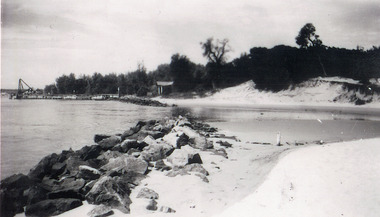
Black and white photograph showing lake shoreline on western side of entrance piers, with rock retaining wall, walings and crane left middle distance and front of Schnapper cottage, dense vegetation on dune and some erosion to beach. Lakes Entrance Victoria machinery, waterfront, houses -
 Lakes Entrance Historical Society
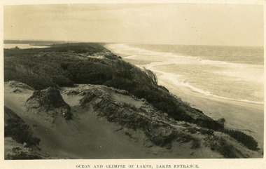
Postcard - Sand Hummocks, Bulmer H D, 1940
Black and white postcard taken from the hummocks to the west. View is looking to the east showing ocean and beach, wind swept scrub covered dunes, and distant view of Gippsland Lakes. Lakes Entrance Victoriawaterfront, ocean, topography -
 Lakes Entrance Historical Society
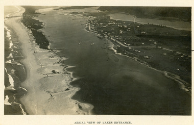
Photograph - Lakes Entrance, 1923c
Two copies 16.5 x 25.5 very darkBlack and white photograph showing early aerial view of township of Lakes Entrance, photo shows highway going along Myer Street and along Roadknight Street, no shops in Myer Street appears to be no foot bridge, therefore taken prior to 1937, sparce vegetation on foreground dunes, four barriers built on dunes to stop erosion through sand, two masted sailing boat in lake. Bullock Island in distance appears very small, Snake Island of Rigby Island in centre distance. Lakes Entrance VictoriaAerial View of Lakes Entrancewaterways, coast, aerial photograph, islands, township -
 Lakes Entrance Historical Society
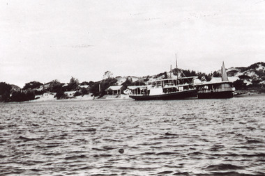
Photograph - New Works Jetty, 1920 c
Also one black and white copy of the same image.Black and white photograph showing two steamers at New Works wharf, Cunninghame Arm,Cottages on dune behind steamers. Top of sail visible behind steamer. Sand showing between vegetation on dunes. Lakes Entrance Victoria.ships and shipping, waterways, jetties, islands -
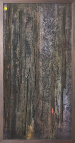 Merri-bek City Council
Mixed media - Callistemon charcoal and ink on marine ply, Brian McKinnon, Bush Fire I “Redgum Sleeper”, 2019
... tin and timber from the rubbish tip over the sand dune. Our ... -
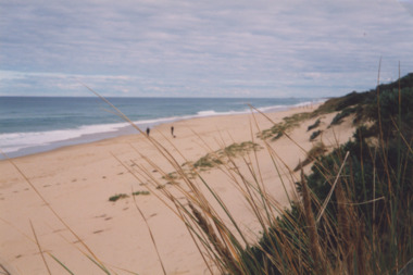 Lakes Entrance Historical Society
Photograph - Ocean Beach, Lakes Post Newspaper, 1/06/2000 12:00:00 AM
... covered coastal dunes, two people on sand Lakes Entrance Victoria... calm ocean and shrub covered coastal dunes, two people on sand ...Colour photograph taken from Eastern Beach looking towards the west showing expanse of sand between calm ocean and shrub covered coastal dunes, two people on sand Lakes Entrance Victoriacoast, ocean, waterways