Showing 14001 items
matching snowy-river-bridge
-
 Orbost & District Historical Society
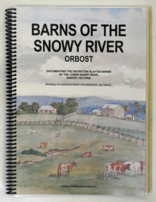
book, Barns of the Snowy River Orbost, 2006
This is a book written by a local historian containing historical information pertaining to Orbost and the surrounding district. A spiral bound book of 191pp. On the front and back covers are coloured print of the Morgan Barn c 1900, an original watercolour, artist unknown. The book documents the distinctive slatted barns of the lower Snowy River, Orbost, Victoria. The book was published by the Orbost Historical Society and was written by May Leatch and Ngaere Donald. It contains B/w photographs, drawings and stories of the barns and their histories.history-agriculture-orbost barns-slatted -
 Orbost & District Historical Society
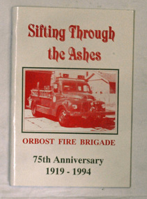
books, Sifting Through The Ashes, 1994
The book was collated by Debbie Hall. Orbost Fire brigade was founded in 1919. The first captain was George Hodgson, assisted by Lieutenant Reg Macalister, Secretary J.F.McCoy and fifteen members. .As there was no fire station the ree l ( a cast off fro m the Bairnsdale Brigade ) w as kep t in the shed at the back of the Council Chambers until the present Station was built in 1922 in its present location in Gladstone Street, Orbost. This book is a written record of the first one hundred years of the Orbost Fire Brigade.Two copies of a paperback book with a white cover and red print. On the cover is a photo of a fire truck in a rectangular frame. The book was produced for the 75th Anniversary of Orbost Fire Brigade 1919-1994. The book contains black and white photographs of Fire brigade activities and extracts from the "Snowy River Mail".In blue pen - "Presented to the Orbost Historical Society from Orbost Fire Brigade - November 12th 1994"book orbost-fire-brigade -
 Kew Historical Society Inc
Photograph, Marnie McLeod, Floods on the River Yarra at Kew, 1916
The donation was accompanied by the following letter from the donor: "Hi. I found these in with family photos. Taken by family as Mamie McLeod was living in Fellows Street, Kew, so would be near there. Retain (or discard) as you see fit." [Donor's name and address withheld from public view]. To gain an insight into the flood levels at Kew, it is worth reading newspaper accounts of the event. The Age published an article - Valuable Gardens Destroyed at Kew - on 25 September 1916: "VALUABLE GARDENS DESTROYED AT KEW. From the heights of Studley Park, Kew, a splendid view of the flood waters can be obtained, and yesterday afternoon, despite continuous rain, crowds of citizens assembled there to witness the spectacle. There is a vast stretch of water some 300 or 400 yards broad, above the foot bridge connecting Gipps-street, Collingwood, and Studley Park. The river is only about 3 feet from the top of the embankment connecting with the ramp of the bridge on the Studiey Park side. When the upper llood waters come down it is almost a certainty that tne embankment will be submerged and the bridge rendered impassible. Below the bridge the waters again stretch out, and have submerged all the low-lying land on the Collingwood side and invaded the back premises ot the Kodak Co., Phoenix Biscuit Factory, a tannery adjoining thereto, the Shamrock Brewery, and Chinese gardens in the vicinity. At Walmer-street-bridge, at the end of Studley Park, the low-lying land on the Kew side is covered with water to the depth of many feet. Tlie land in question is owned in a great part by Mr Frank Lavers who haa gone in for intense culture on a pretty liberal scale on both the slopes of the hill and on the river flat. On the latter he is cultivating many acres of asparagus, and has at a considerable cost spent three years in preparing the ground and installing an irrigation system, reticulated from the Yan Yean water supply. This year the asparagus was put down, and the plants were in a promising condition. Tlie flood waters are now flowing fast over the land. The crop is ruined, and three years' work and expenditure destroyed. Mr. Laver's private residence fortunately is high above flood level, but two houses he owns off Young-street have been flooded out. Having been warned in time, the tenants removed their furniture hefore the water came down to Mr. Laver's residence, where they themselves have been given accommodation in the meantime. All the river flats in East Kew are under water. One or two low-lying houses have been flooded. Chipperfield's boat shed at Willsmere is nearly covered, and some Chinese gardens in the vicinity are several feet under water."This, and the other three photographs donated of floods in Kew are believed to be the earliest in the collection. Together with our original MMBW River Yarra map showing flood levels, these items, when compared allow researchers to gain a visual perspective of the extent of the flood in 1916. Panoramic view, believed to be looking north towards Fairfield from the Zig-Zag Bridge on the River Yarra. The inscription on the reverese identifies it as taken before 1920.Inscription on reverse in ink "(pre 1920) Flood from Zig-zag bridge Yarra River, Kew Vic."river yarra, kew, floods 1916, zig-zag bridge -
 Orbost & District Historical Society
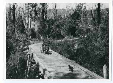
black and white photograph, 1913
This photograph is of the low level bridge across the Bemm River about 50 km east of Orbost in East Gippsland.This is a pictorial record of the 1913 low level bridge across the Bemm River, East Gippsland.A large black / white photograph of a horse - drawn wagon on the low level Bemm River bridge. In the foreground on the bridge is a dog.on back - "Country Roads Board Princes Highway low level bridge" -
 Orbost & District Historical Society
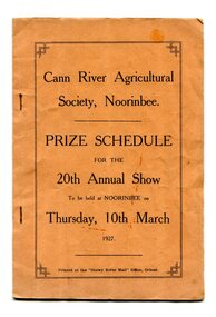
program, Snowy River Mail, 1927
Cann River is a town in the East Gippsland region of Victoria in Australia. The town is located on the Cann River at the junction of the Princess Highway and the Monaro Highway, in the Shire of East Gippsland. Before 1929 the original Cann River settlement was where Noorinbee now stands.Agricultural shows are an important part of cultural life in small country towns and these shows form an integral part of local history. This item reflects the significance of a volunteer group which no longer exists.A stapled paper program, orange with black print,"Cann River Agricultural Society, Noorinbee Prize Schedule for the 20th Annual Show to be held at Noorinbee on Thursday 10th March 1927" inside a rectangular black frame. -
 Orbost & District Historical Society
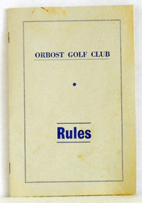
booklet, Snowy River Mail as "Mail" Print, Orbost Golf Club Rules, 1968
Published by the Orbost Golf Club.The golf club was established in 1906 it was originally formed as the Snowy River Golf Club and played on private land near the banks of the Snowy River just to the south of town. In the 1930’s the Golf Club relocated to its present site and was renamed Orbost Golf Club. The land was shared by the Show grounds and Racing Club. Orbost Golf Club later acquired the land outright to provide a permanent home for golfers in Orbost and surrounding district.A thin, 24pp booklet with a grey cover titled "Orbost Golf Club Rules". It contains the rules of the Orbost Golf Club and has a loose sheet with amendments. The cover has blue print.orbost-golf-club recreation sport golf -
 Orbost & District Historical Society
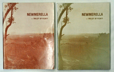
books, Snowy River Mail, Newmerella - Valley of Plenty, March 1978
This book is a useful reference tool on the history of Newmerella.Four copies of a 80 pp soft covered stapled book with a light brown cover with the title, "NEWMERELLA - VALLEY OF PLENTY' in a darker brown print at the top. Below is an illustration of the Snowy River flats. It contains an outline of the history of Newmerella from the beginning of the 19th century until 1978. There are black/white photographs, detailed information and maps.newmerella-history valley-of-plenty -
 Orbost & District Historical Society
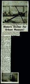
newspaper clippings, 1928 - 1975
These newspaper articles were collated by Mary Gilbert. Mary Isabelle Gilbert was born in 1905 in Orbost, Australia. She was born to John Gilbert and Annie Cameron Gilbert, and had seven sisters and one brother. Four siblings died at a young age. She was a teacher historian loved and respected by her family and the wider community.These articles are contemporary records of events in the history of Orbost and as such are useful reference tools.A manila folder containing black / white newspaper cuttings of articles relating to the local history of Orbost. They are from the Snowy River Mail. 746.1 is titled, "Historic anchor for Orbost Museum". 746.2, August 9, 1967, is titled, ""Orbost Historical Museum". 746.3 is titled, "When The Snowy Was Angry". On the back is "Resident's Sudden Death - Mrs Ada Bowtell (67)". 746.4 from 1934 is titled, "The Duke's Visit - Welcome at Cann River'. 746.5, Wednesday November 24, 1954 is titled, "Naming of Orbost District Landmarks". 746.6, Wednesday November 24, is titled, " Convict First White Settler in Orbost District?". 746.7, Wednesday, July 25, 1928 is titled, " Dedication of St James' Memorial Church, Orbost". 746.8 and 746.9, Wednesday September 24, 1975 are titled, "Piece of History Returns".orbost- museum anchor-orbost street-names-orbost st-james'-orbost -
 Port Fairy Historical Society Museum and Archives
Photograph
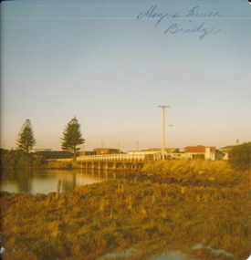
Moyne River Bridge 1970's North sideColoured photograph of Moyne river traffic bridge taken from the North side on the West bankMoyne River Bridge- on frontmoyne river, bridge, west side -
 Orbost & District Historical Society
black and white photograph, August 1897
This is a photograph of the bridge from the Orbost side. The first pile bridge over the Snowy River was just completed by Mr Jim Granter when the 1891 flood took out the centre,. There were differences of opinion as to whether the council should pay . The Shire Secretary, Mr John Draffin, persuaded them to honour their obligations. Mr Granter and Mr Clarke finished it as a suspension bridge which was opened by Mrs William Watt. Soon after a mob of cattle stampeded, the weight snapped the cable, letting one side sag. Mr R.P. Cameron repaired it and this bridge remained until 1922. "In 1890 the contract for a bridge was let to Mr James Granter for £1450. This structure with additions and improvements made to it was to cost the ratepayers about £2,500, and its erection was proceeded with in a very satisfactory manner until, just as the greater-part of the work had been completed, the flood of 1891 came down on it, piling up mountains of logs, timber and debris against the piers, which had not been made wide enough apart to allow for. contingencies of this kind. The structure held out bravely until the turn of the flood and then gave way with a crash, about five bays from the centre disappearing in the stream." ( Snowy River Mail August 12 1893) This item is a pictorial record of one of the first bridges across the Snowy River in Orbost.A black / white photograph of the old wooden suspension bridge over the Snowy River. There are two copies 919.1 and 919.2. There are two other photos showing the whole bridge taken from further back.on back - "Orbost Bridge...."snowy-river-bridge-orbost granter-james -
 Stawell Historical Society Inc
Slide, Ian McCann, Wimmera River Bridge at Joel 1957, 1957
Wimmer River Bridge at Joel 1957wimmera river, joel area, joel bridge -
 Orbost & District Historical Society
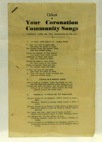
booklet, Your Coronation Community Songs, 1953
This booklet was printed by the Snowy River Mail newspaper to be used at a community event celebrating the Coronation of Her Majesty Queen Elizabeth II in the Abbey Church of St. Peter, Westminster, on Tuesday, the second day of June, 1953. The coronation of Queen Elizabeth 11 was a significant event in 1953. This booklet is representative of a community event.A booklet containing word of songs for a community celebration of the coronation of Queen Elizabeth 11. It is titled "Your Coronation Community Songs". For Tuesday June 2 1953 at 7.45pm.coronation booklet-songs souvenir -
 Orbost & District Historical Society
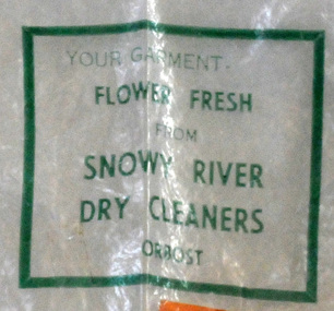
plastic bag, c 1960's
Snowy River Dry Cleaners was situated in Stanley Street, Orbost (previously a hat factory). There was also a shop in the CBD of Orbost. Basil Dowie moved his dry cleaning business from Nicholson Street to 31 Stanley Street where Stuart Hats had been. He had originally bought the business from Laurie Harrington in August 1950. (more information in Orbost & District Historical Society Newsletter No. 138 - John Phillips) This item is from a business no longer existing.A clear plastic bag with green print. - Snowy River Dry Cleaners. attached is orange card - E. Scott 004408Your garment Flower Fresh from Snowy River Dry Cleaners Orbostdry-cleaners-orbost laundry -
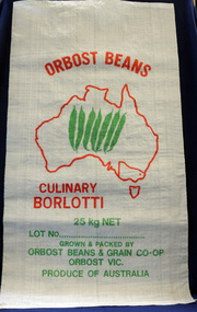 Orbost & District Historical Society
seed bag, mid 20th century
Orbost Beans & Grains Co-Op was an extension of Snowy River Sweet Corn Co-Op which also sold fresh produce such as corn, squash, zucchini and cucumbers. This bag is unused and would have been packed with borlotti beans.Snowy River Seeds started life as a farmers' co-operative (Snowy River Co-op) in 1967. This item is significant because it was specially made for the seed bean industry which was a major industry in the Orbost district for over a century. A white woven synthetic bag used for packing borlotti beans. Inside a red outline of Australia are seven green beans. Victoria is outlined and Orbost is indicated with a red d t. Print is red and green. On front : Grown & Packed By Orbost Beans & Grain Co-Op 25 kg Orbost Victoria Produce of Australia seed-bag snowy-river-co-op agriculture farming orbost-beans -
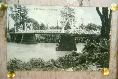
 Orbost & District Historical Society
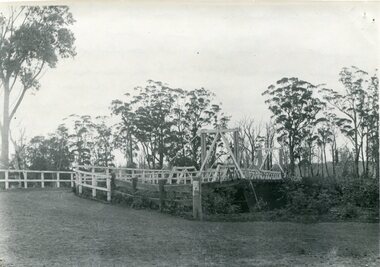
black and white photograph, Howard D. Bulmer, first half 20th century
... Snowy-River-bridge ...A new bridge over the Snowy River at Orbost was opened for traffic on June 20th 1922. It was intended as a road and rail bridge, and was again partly washed away by flood waters in 1934. After the end of the first World War the Victorian Railways considered an extension of the railhead across the river at Orbost, and in 1922 a new timber and steel girder structure, a joint Country Roads Board — Victorian Railways venture, was built and completed at a cost of £41,000 (the steel girders came from the Flinders Street viaduct reconstruction). Subsequently it was decided decided not to take the railway across the river, and the bridge was only used by road traffic. This is a pictorial record of an early bridge over the Snowy River at Orbost.A black / white postcard photograph of a bridge across a shallow river with men on horseback underneath.snowy-river-bridge -
 Ballarat Heritage Services
Photograph, Lisa Gervasoni, Bridge over the Avoca River, Victoria, 2011, 06/08/2011
Colour photographs of a bridge over the Avoca Riveravoca, avoca river, pre olympic swimming pool -
 Ballarat Heritage Services
Photograph, River Boats Below Murray Bridge, South Australia
River Boats on Murray Bridge, South Australia.river boats, murray bridge, south australia -
 Ballarat Heritage Services
Photograph - Colour, L.J. Gervasoni, Bridge Over the River, Avoca, 2011, 06/08/2011
Colour photograph of the Bridge Over the River at Avoca.avoca, bridge, avoca river -
 Ballarat Heritage Services
Photograph - Colour, L.J. Gervasoni, Bridge Over the River, Avoca, 2011, 06/08/2011
Colour photograph of a bridge over the Avoca River.avoca, bridge, avoca river -
 Lakes Entrance Historical Society
Photograph - Bridges, 1920
First bridge over the Snowy River at Orbost built 1891Black and white photographic print showing early first bridge across Snowy River thick vegetation along river banks. Orbost Victoriabridges, waterways -
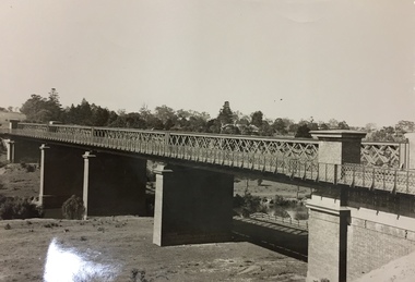
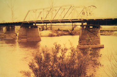 Orbost & District Historical Society
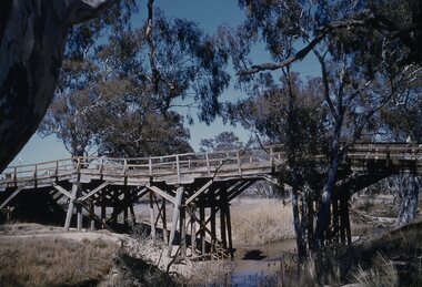
photograph, first half of 20th century prior to 1976
Purchased from Orbost Op shop several years ago. Original owner unknown. This bridge over the Snowy River was opened on July 4 1922. It was constructed in 1922 alongside the previous suspension bridge. Its building was a combined effort of the Victorian Railways and the Country Roads Board at a cost of 35,000 pounds. It was replaced in 1976 by the present bridge after several major floods.This bridge was replaced in 1976 after several major floods.A wooden framed photograph of the second Snowy River bridge at Orbost.photograph snowy-river-bridge -
 Stawell Historical Society Inc
Photograph, Bridge over Wimmera River at Glenorchy
Bridge over Wimmera River at Glenorchy. Church in background on right is the former Presbyterian now United Church. Original photograph taken by Charles Nettleton.Black & white photograph of a timber lined water body with bridge and building in the background. water -
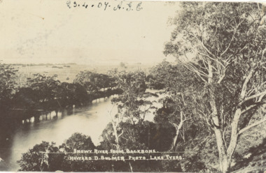 Lakes Entrance Historical Society
Postcard - Snowy River showing Backbone Point, H D Bulmer, Orbost Victoria, 1905 c
Black and white postcard of Snowy River showing Backbone point Orbost VictoriaSnowy River from Backbonerivers, topography -
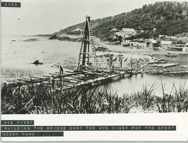 Lorne Historical Society
Photograph, Building of the bridge at Wye River, on G.O.R
Photograph showing construction of the bridge at Wye River on the G.O.R.g.o.r; wye-river; g.o.r; bridge-construction; -
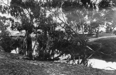
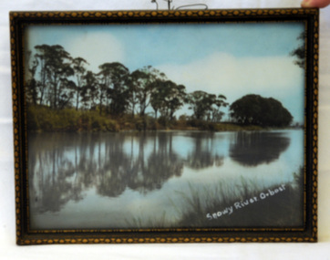 Orbost & District Historical Society
photograph, 1937
The photo was probably taken by Will Herbert and used at the 1937 "Back to Orbost" celebrations. The photo depicts the Snowy River at Orbost when it was at a high level.A coloured photograph in a brown wooden frame which has gold painted decorated edges. A wire hanger is attached. The photo shows reflections of trees along the bank of the Snowy River in 1937.On bottom right of photo - Snowy River Orbost On back of frame - Back to Orbost 1937 from Will Herbertphotography snowy-river orbost-1937 -
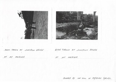 Buninyong & District Historical Society
Photograph - Photocopy of two original B/W photographs, Mt Mercer Junction Bridge, photocopy made in 1995
Photos taken of the Junction Bridge at Mt Mercer, documenting the location, date unknown.The photos document the physical status of the location of the Junction Bridge at Mt Mercer at the time of photography, date unknown.Mt Mercer Junction Bridge. Photo 1 shows two men on the river bed probably looking at the bridge. Photo 2 shows Elsie Gibson sitting on the river bank with the bridge in the background.Photo 1. Photo taken at Junction Bridge at Mt Mercer. Photo 2. Elsie Gibson at Junction Bridge at Mt Mercer. Donated by Ian Hill of Hepburn Springsjunction bridge, mt mercer, bridge, elsie gibson, gibson, landscape -
 Kew Historical Society Inc
Photograph, Outer Circle Railway Viaduct, 1919
Railway Viaduct constructed for the Outer Circle Railway. Bridge designed by John Monash, engineer. Converted into a state highway, 1930s.Dateable photo of an important piece of Victorian railway infrastructure.Photograph of Outer Circle Railway Bridge over River Yarra, Fairfield. Looking toward Lugton Street, showing fence underneath taken from the Chandler Highway. Reverse: "Outer Circle Railway Bridge over River Yarra Fairfield, H0276, Property of Miss Foley"railway viaduct, chandler highway -
 Orbost & District Historical Society
programs, 1961
The Snowy River Shire was a local government area in the Australian Alps region of New South Wales, Australia from 1939 until May 2016. It was named after the Snowy River that runs through it. Prior to 1936, it had been named as Dalgety Shire since establishment in 1906. This opening of the Monaro - Gippsland Road took place on 4th May 1961. There had long been a movement in Monaro for the construction of a road to connect Monaro and Gippsland, via Inglebyra and Black Mountain. The only track was for stock, made by pioneers many years ago, and it was very circuitous. It was stated at a meeting at Dalgety that the road would open up large areas for settlement for grazing, and for timber suitable for bridgé building. The road would assist stock deal ing between Monaro and Gippsland. It would also considerably shorten the distance from Victoria for tourists visiting Canberra and Kosciusko. A committee was formed to put the proposal before the Dalgety Shire Council in the 1930s.This item is a useful research tool.Four copies of a road opening program. It has black print on white. There are black / white photographs, historical details and details of the official opening.program monaro-road snowy-river-shire -
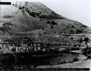 Lorne Historical Society
Photograph, St George River Bridge opening 1926
Photograph showing crowd at the opening of the bridge over the George River in 1926 g.o.r; george river bridge 1926; -
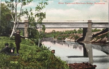 Kew Historical Society Inc
Postcard, Valentine's Series, River Yarra and Hawthorn Bridge, Melbourne, c.1907
Valentine's Series postcard, printed in Great Britain by Valentine’s Co. Ltd. (Valentine & Sons 1825-1963) for Australian distributionEarly postcard of the Hawthorn to Burnley Railway Bridge on the River Yarra. Station picnic on left. Tay Creggan on right. Buildings and location identified by Marshall Slattery in 1977. The postcard was printed in Great Britain and was published as one of Valentine's Series. "KH.87. Donated by Mrs B. Challen 2.2.76. Burnley to Hawthorn Railway Bridge. Station Picnic on left. "Tay Creggan" on right. Marshall Slattery 1977".river yarra, railway bridge - hawthorn, postcards -- hawthorn (vic.)