Showing 294 items matching "stone's corner"
-
 Flagstaff Hill Maritime Museum and Village
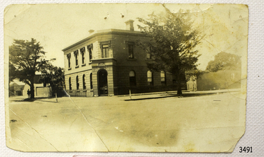
Photograph - Building, Bank of Australasia Warrnambool, ca. 1860
This sepia coloured photograph show the image of the former Bank of Australasia in Warrnambool. The two-storey building was built for the bank on the corner of Timor and Kepler Streets and opened there for business in 1860. It is now one of the City's Historic Buildings. The Bank of Australasia was incorporated by Royal Charter of England in March 1834. It came to Australia on 14th December 1835, opening in Sydney. The Acting Superintendent of the Bank of Australasia in Sydney at that time was David Charters McArthur. He was Superintendent from 1867-to 1876. The Melbourne branch of the Bank of Australasia opened on 28th August 1838 in a two-roomed brick cottage on the north side of Little Collins Street. Two huge mastiff dogs were kept in the backyard and let loose at night to guard the bank. The government also provided an armed military sentinel. Due to the bank's rapid growth, a new building for the Melbourne branch was opened in 1840 at 75 Collins Street West. By 1879 the bank had been upgraded to a magnificent two-storey building on the corners of Collins and Queens Streets, with the entry on Collins Street. In 1951 the Bank of Australasia amalgamated with the Union Bank to form the Australia and New Zealand Bank, now known as the ANZ. Then in 1970, the ANZ merged with both the ES&A and the London Bank of Australia to form the ANZ Banking Group Limited. The ANZ Banking Group Ltd kindly donated a variety of historic items from the Bank of Australasia. BANK of AUSTRALASIA, WARRNAMBOOL – In 1854 Warrnambool had two banks, the Union Back and the Bank of Australasia. Later, completely different bank businesses opened; in 1867 the National Bank of Australasia, then in 1875 the Colonial Bank of Australasia. The original Warrnambool branch of the Bank of Australasia was established in July 1854, and operated from a leased cottage on Merri Street, close to Liebig Street. The bank later bought a stone building previously erected by drapers Cramond & Dickson on the corner of Timor and Gibson Streets. Samuel Hannaford was a teller and then Manager at the Warrnambool branch from 1855 to 1856 and the Warrnambool Council chose that bank for its dealings during 1856-57. In 1859 Roberts & Co. was awarded the contract to build the new Bank of Australasia branch for the sum of £3,000. The land was on a sand hill on the northeast corner of Timor and Kepler Streets and had been bought in 1855 from investor James Cust. The new building opened on May 21, 1860. The bank continued to operate there until 1951 when it merged with the Union Bank to form the ANZ Bank, which continued operating from its Liebig Street building. Warrnambool City Council purchased the former Bank of Australasia building in 1971 and renovated it, then on 3rd December 1973 it was officially opened as the Art Gallery by Cr. Harold Stephenson and Gallery Director John Welsh. The Gallery transferred to the purpose-built building in Liebig Street in 1986 and the old bank building is now the Gallery club. Staff at the Bank of Australasia in Warrnambool included the following men but others were also involved: Samuel Hannaford, Teller then Manager from 1855-1856; W H Palmer, Manager from January 1857 until November 1869 when the Teller Basil Spence was promoted to Manager; H B Chomley, Manager from April 1873 and still there in 1886; A Butt, Manager in 1895-1904; J R McCleary Accountant and Acting Manager for 12 months, until 1900; A Kirk, Manager 1904; J Moore, staff until his transfer to Bendigo in December 1908; J S Bath was Manager until 1915; C C Cox, Manager until April 1923; Richard C Stanley, Manager 1923 to April 1928. The photograph is significant historically for its connection with the Bank of Australasia. The early Australian bank was established in 1834 by Royal Charter and opened in Sydney, Australia, in Sydney in 1835. The bank had many Australian offices in November 1877, particularly on the east and south coasts. Victoria had 45 percent of all Offices. The photograph has local historical significance for its association with the Warrnambool Bank of Australasia, which was established early in Warrnambool's history. It was Warrnambool Council’s first bank. The bank continued to operate until the organisation's merger in 1951 when it became the ANZ Bank Group of today. The Bank was an integral part of the growth of local commerce and the community.Black and white (or sepia) rectangular photograph, landscape orientation. Image of a two-storey building on a street corner. It is the former Bank of Australasia, Warrnambool, on the corner of Timor and Kepler Streets that was built in 1860. The reverse has a round, serrated-edged red label with an inscription, covered in opaque tape, plus four lines of handwritten text. There are several pin holes through the photograph.Label with: "AH2 2 / W.BOOL" Writing in pen: "D. K. Frew / --- / ---- / ----"flagstaff hill, warrnambool, shipwrecked coast, flagstaff hill maritime museum, maritime museum, shipwreck coast, flagstaff hill maritime village, great ocean road, bank of australasia, boa, union bank, australia & new zealand bank, anz bank, david charters mcarthur, d c mcarthur, commerce, banking, samuel hannaford, w h palmer, basil spence, h b chomley, a butt, j r mccleary, a kirk, j moore, j s bath, c c cox, richard c stanley, historic building, roberts & co., james cust, bank of australasia warrnambool -
 Glenelg Shire Council Cultural Collection
Print - Reduction Linocut, Bob Stone, Working Tug II, c. 2015
Reduction linocut, blue, grey, white, red, green, black; white mount, blondewood frame, reflective glasss. Hanging wire across width of frame, on backFront: '1/7 linocut Working Tug II Bob Stone 2015 Back: Holland's Picture Framing, black stamp, lower left corner -
 Mission to Seafarers Victoria
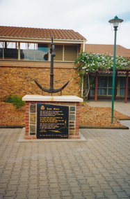
Photograph - Photograph, colour, c. 2001
Opened by His Excellency Sir Eric Neal AC CVO on 30 September 2001, the Memorial is located in City Park, Port Pirie, South Australia. The monument commemorates those who were lost at sea while serving with the Merchant Navy. Mr Noel Smith, a resident of Port Pirie, former Merchant Navy seaman and Port Pirie tugboat officer designed the memorial, found the anchor located on the top of the memorial during a dredging operation in a creek near the Nystar plant and wrote the poem inscribed on the main plaque. Front Inscription Lost Ones They live in the curl of the breaking wave, They sing when the sea winds blow, They lay not confined in a land locked grave, Nor in dim dark depths below. Do you hear them laugh in the rippling tide, Call free in the ocean breeze ? Do you see them soar where great gulls glide At peace with the fearsome seas ? They live still in the hearts of those who wait Held strong in the bonds of love 'Til their souls unite and congregate In God`s great harbour above. Noel Smith Merchant Seaman For those who were lost to the depths of the sea Emma Hindmarsh Left Side Inscription Memorial unveiled by His Excellency Sir Eric Neal AC CVO Governor of South Australia and His Worship the Mayor Ken Madigan Port Pirie Regional Council Memorial blessed and consecrated by Right Reverend Garry Weatherill Bishop of Willochra 30 September 2001Colour photograph of the memorial made of an anchor on a bricks and stones base with a black marble plaque titled The Lost Ones. The logo of the Merchant Navy, MN, on the top left corner of the plaque.merchant navy, mn, port pirie, memorial -
 Greensborough Historical Society
Photograph, Main Road bridge looking to township of Greensborough, 1929c
View of Main Street Greensborough from Partington's Hill including Plenty River bridge and Marble Hall on corner of Carter Street (now Para Road) and Main Street. This view of Greensborough Park shows the old pan toilets, the hawthorn fence line and the rather undeveloped roadside area of the park. Looking up Main Street we see the old Chapman house at the corner of Poulter Avenue and some newer houses below this. The stone river bridge appears to be only a single lane wide and the road approaching the bridge is unsealed. The rail bridge shows evidence of soot from steam trains and at the extreme left of picture the two concrete buildings indicate the line had been electrified. This occurred in 1923. Sparse housing is seen in the Flintoff Street and Grimshaw Street area.Part of a collection of photographic enlargements of views of Greensborough in the early 1900s.Black and white enlargement of photographic imagemain street greensborough, marble hall, greensborough railway, chapman house, greensborough park, poulter avenue greensborough, carter street, para road -
 Greensborough Historical Society
Photograph - Digital Image, Pioneer Reserve 2014 -1, 21/05/2014
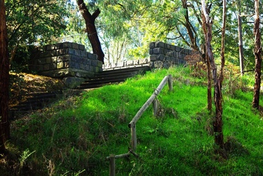
Pioneer Reserve, Greensborough is a small park on the corner of St Helena and Diamond Creek Roads. It is adjacent to the site of Greensborough's first bridge across the Plenty River, c. 1864 - 1960s. The shelter, viewing platform, retaining wall and entrance are built from the bridge's massive bluestone arched abutments dismantled between 1974 and 1983. Pioneer Reserve is historically significant for its formative association with noted local landscape designer Gordon Ford in 1968, and it is likely that remnant large field stones at the entrance drive to the Reserve remain from his design. Photograph by Marilyn Smith 2014.Digital copy of colour photograph. -
 Greensborough Historical Society
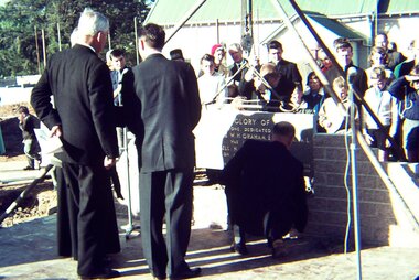
Photograph - Digital Image, Ken Wandin, All Saints Anglican Church Greensborough. Laying foundation stone 1966, 07/05/1966
In 1970, All Saints' Anglican Church was rebuilt on the corner of Church and Grimshaw Streets Greensborough, replacing the timber church. This photograph shows the official laying of the Foundation Stone in the late 1960sDigital copy of colour photographall saints anglican church greensborough -
 Glenelg Shire Council Cultural Collection
Postcard - Postcard - St Stephens Church, Portland, n.d
Black and white photograph of a bluestone church, with a large tree casting it in shadow. In front is a stone and metal rail fence, with large metal gates where the two sides of the fence meet on the corner of the block.Front: (no inscriptions) Back: St Stephens Church Portland -
Glenelg Shire Council Cultural Collection
Photograph - Photograph - Cape Bridgewater School, n.d
Black and white photo, ruins of Cape Bridgewater school; stone walls, tin roof, half missing, no glass in windows, trees growing over and through the ruins. Barbed wire fence around it.Front: 'Cape Bridgewater School - ruins still there' - handwritten, black biro, across top of photo Back: '13' - top left corner, blue birocape bridgewater, school, ruin, building -
Glenelg Shire Council Cultural Collection
Photograph - Photograph - Marine Discovery Centre Portland, Victoria, c. 1998
Coloured photograph: MDC, inside. Activities corner - 'Try some knots' bench, 1/2 barrel, nets, stones etc. -
 City of Moorabbin Historical Society (Operating the Box Cottage Museum)
Document - Genealogy Chart Henry Dendy (Photocopy), 19 thC
In 1840 Henry Dendy, a farmer in Surrey, England acquired a "Special Survey" from the Commissioners for Land and Emigration which gave Dendy the right to choose land in Port Phillip for the "bargain basement" price of only £1 per acre for 5120 acres, (an area of 8 square miles). The Special Survey also included the right to "the shipment of a worker for every £20 spent on land, whose free passage was paid by the Crown, equalling a total of 100 workers ". Accordingly Dendy sold his English holdings and paid the required £5120 and arrived in Melbourne in February 1841. However by this time land in the new colony was selling for £5 - £40 per acre. Because Henry Dendy possessed the order from the Colonial Office in London he was able to successfully oppose Super-intendant LaTrobe's attempts to alter the price of the land. Dendy appointed Jonathan Were, (an entrepreneur, who had arrived in 1839), as his Manager and who later became a partner. Together, Dendy and Were decided on an area 5 miles south from Melbourne, bounded by North Road, East Boundary Road, South Road and to the west by Port Phillip Bay. Were and Dendy pitched their tents in the area now known as ' Park St, Brighton' and sank a well near the corner of 'St Andrew's St and Wells St'. By 1845 J.B Were and Company had bought almost half of Dendy's land and Were built himself "Moorabbin House" in Were St Brighton made from stone, quarried from local cliffs. It was still standing in 1924. Legend records Moorabbin is named after the Aboriginal word for ' Mother's Milk ' The soil is very fertile and well supplied with water especially in the area called 'East Brighton' - now known as Bentleigh and East Bentleigh - By 1850 the area had developed with numerous market gardens, dairy farms, fruit gardens and vineyards supplying food for the growing population of Melbourne.In 1840 Henry Dendy, a farmer in Surrey, England acquired a "Special Survey" from the Commissioners for Land and Emigration which gave Dendy the right to choose land in Port Phillip for the price of only £1 per acre for 5120 acres. This land was called Brighton in the Parish of Moorabbin, County of Bourke and emigrants developed the land establishing market gardens , dairy and poultry farms that provided the food for the growing population of Melbourne. A photocopy of the Genealogy Chart of the Dendy Family that Henry Dendy brought with him when he emigrated to Melbourne 1841Genealogy signs and descriptionsdendy henry, dendy's special survey brighton 1841, governor gipps, captain lonsdale, super-intendant latrobe, port phillip, melbourne, new south wales, squatters, emmigrants, county of bourke, parish of moorabbin, early settlers, pioneers, market gardeners, dairy farmers, fruit farms, moorabbin, bentleigh, brighton, cheltenham, were jonathan binn, -
City of Moorabbin Historical Society (Operating the Box Cottage Museum)
Document, Henry Dendy family Shield
In 1840 Henry Dendy, a farmer in Surrey, England acquired a "Special Survey" from the Commissioners for Land and Emigration which gave Dendy the right to choose land in Port Phillip for the "bargain basement" price of only £1 per acre for 5120 acres, (an area of 8 square miles). The Special Survey also included the right to "the shipment of a worker for every £20 spent on land, whose free passage was paid by the Crown, equalling a total of 100 workers ". Accordingly Dendy sold his English holdings and paid the required £5120 and arrived in Melbourne in February 1841. However by this time land in the new colony was selling for £5 - £40 per acre. Because Henry Dendy possessed the order from the Colonial Office in London he was able to successfully oppose Super-intendant LaTrobe's attempts to alter the price of the land. Dendy appointed Jonathan Were, (an entrepreneur, who had arrived in 1839), as his Manager and who later became a partner. Together, Dendy and Were decided on an area 5 miles south from Melbourne, bounded by North Road, East Boundary Road, South Road and to the west by Port Phillip Bay. Were and Dendy pitched their tents in the area now known as ' Park St, Brighton' and sank a well near the corner of 'St Andrew's St and Wells St'. By 1845 J.B Were and Company had bought almost half of Dendy's land and Were built himself "Moorabbin House" in Were St Brighton made from stone, quarried from local cliffs. It was still standing in 1924. Legend records Moorabbin is named after the Aboriginal word for ' Mother's Milk ' The soil is very fertile and well supplied with water especially in the area called 'East Brighton' - now known as Bentleigh and East Bentleigh - By 1850 the area had developed with numerous market gardens, dairy farms, fruit gardens and vineyards supplying food for the growing population of Melbourne. dendy henry, dendy's special survey brighton 1841, governor gipps, captain lonsdale, super-intendant latrobe, port phillip, melbourne, new south wales, squatters, emmigrants, county of bourke, parish of moorabbin, early settlers, pioneers, market gardeners, dairy farmers, fruit farms, moorabbin, bentleigh, brighton, cheltenham, were jonathan binn, -
 City of Moorabbin Historical Society (Operating the Box Cottage Museum)
Document - Pedigree of Henry Dendy, c1840 Original ; Copy 1985
This is a copy of the document brought by Henry Dendy to the Colony in 1841. In 1840 Henry Dendy, a farmer in Surrey, England acquired a "Special Survey" from the Commissioners for Land and Emigration which gave Dendy the right to choose land in Port Phillip for the "bargain basement" price of only £1 per acre for 5120 acres, (an area of 8 square miles). The Special Survey also included the right to "the shipment of a worker for every £20 spent on land, whose free passage was paid by the Crown, equalling a total of 100 workers ". Accordingly Dendy sold his English holdings and paid the required £5120 and arrived in Melbourne in February 1841. However by this time land in the new colony was selling for £5 - £40 per acre. Because Henry Dendy possessed the order from the Colonial Office in London he was able to successfully oppose Super-intendant LaTrobe's attempts to alter the price of the land. Dendy appointed Jonathan Were, (an entrepreneur, who had arrived in 1839), as his Manager and who later became a partner. Together, Dendy and Were decided on an area 5 miles south from Melbourne, bounded by North Road, East Boundary Road, South Road and to the west by Port Phillip Bay. Were and Dendy pitched their tents in the area now known as ' Park St, Brighton' and sank a well near the corner of 'St Andrew's St and Wells St'. By 1845 J.B Were and Company had bought almost half of Dendy's land and Were built himself "Moorabbin House" in Were St Brighton made from stone, quarried from local cliffs. It was still standing in 1924. Legend records Moorabbin is named after the Aboriginal word for ' Mother's Milk ' The soil is very fertile and well supplied with water especially in the area called 'East Brighton' - now known as Bentleigh and East Bentleigh - By 1850 the area had developed with numerous market gardens, dairy farms, fruit gardens and vineyards supplying food for the growing population of Melbourne. A copy of a paper chart of the Pedigree of Henry Dendy in a wooden frame with glassPedigree / of the branch of the family / DENDY moorabbin, brighton, henry dend special survey 1841 y, early settlers, pioneers, market gardeners -
Glenelg Shire Council Cultural Collection
Photograph - Photograph - St. Stephen's Church, Portland, n.d
Black and white photo. View of St Stephen's Anglican church from Percy St. near Julia St. corner. Front and left side visible, blue stone fence, seat on nature stripBack: 'B.V.' top right corner, handwritten, blue biro '3 1/4 wide in prep' - handwritten, pencilst stephens, cofe, place of worship, percy street -
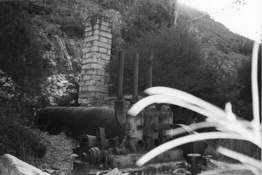 Halls Gap & Grampians Historical Society
Photograph - Coloured, C 1960s (?)
Photo shows steam boiler equipment. Stone chimneys feature in middle of photo. Quarry rockface ^& bushes in background. 'Blurred' leaves appear in bottom right corner.H/GAP0612 NANNAquarrying, mt difficult quarry -
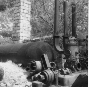 Halls Gap & Grampians Historical Society
Photograph - Coloured, C 1960s (?)
Photo shows close-up view of steam boiler equipment. Stone chimney is also visible, however because of close-up view top of chimney cannot be seen. Wattle tree in bloom is visible in top right corner.quarrying, heatherlie -
 Eltham District Historical Society Inc
Negative - Photograph, J.H. Clark, Jarrold family and cottage, Main Road, Eltham, 1911
Jarrold family and cottage, Main Road, Eltham Members of the Jarrold family and others outside their home in Maria Street (Main Road), Eltham at the bottom of Policeman’s Hill, opposite Dalton Street. The small youth in centre foreground is believed to be George Coleman (see SEPP_0745). John Jarrold (1865-1909) was a local builder and contractor and widely respected resident. Youth in centre is believed to be George Coleman (1906-1953) (See SEPP_0745). Jarrold Cottage built in 1863, also known as 'White Cloud", located at 701 Main Road, Eltham, opposite Dalton Street. The house remains intact and is listed on the Victorian Heritage Database and considered historically significant to the Shire of Nillumbik. The cottage was originally located closer to the Diamond Creek but was subject to flooding. It was dragged by horse to the present site shown, which was chosen for the higher ground that had been created as a result of land fill being deposited here from the quarry further around the bend on Main Road (site of present-day Eltham Primary School carpark) where the stone had been quarried for building the State School in Dalton Street. It had previously been rented for use as a Police Station / residence prior to the building of the permanent police house and station at the corner of Maria and Brougham streets in 1859. At the time of collection of photos for the centenary of the Shire of Eltham (1971) the cottage was owned by the Skipper family and remains in the family to present day (2021). Photo dated as 1911 (by donor?). Photo SEPP_0745 was dated 1905 (by donor?) but is estimated to be c.1909. It is also noted it is thought Jack Coleman is in both photos though it is more likely to be his younger brother George who appears about 5 in this photo and 3 in 745. Cross Reference SEPP_0745 / 748 Photographer: J.H. Clark John Henry Clark was the youngest of three boys born to William Henry Clark (1823-1877) and Maria White (1843-1914). He and his brothers, William Charles Clark (1872-1945), Clement Kent Clark (1874-1912) operated a photography business (Clark Bros.) from 25 Thomas Street, Windsor near Prahran during the period c.1894 to 1914. Following death of Clement in September 1912 and their mother in 1914, the Clark Bros business appears to have dissolved, the premises demolished, and a new house was under construction in 1915. John set up business independently in 1914 operating out of 29 Moor Street, Fitzroy where he is registered in the 1914 and 1915 Electoral Rolls. By 1916 John had relocated to Eltham where he continued his practice as a photographer and took many of the early images around the district of Little Eltham. Around 1930 John changed professions and opened a small cobbler's shop in 1931 near the pond opposite Dalton Street adjacent to the Jarrold family cottage. He never married and continued his profession as a bootmaker from this little shop, maintaining a close relationship with Mrs Jarrold for the rest of their lives. His bootmaker shop remains today beside the Whitecloud cottage and is one of only three remaining shops in the area from the early 20th century. There are a couple of images of Eltham taken by Clark Bros. in the Eltham District Historical Society collection, one such example being Hunniford’s Post Office with Miss Anne Hunniford out front (EDHS_00140 - marked on the back of the print, Clark Bros., 25 Thomas St. Windsor), which would date this image between c.1894 and 1914. Other early images of Eltham taken by John Henry Clark are marked on the face “J. H. Clark Photo” and it is assumed these are dated between 1914 and 1930. It is noted that the Grant of Probate for John H Clark of Eltham South dated 5 April !957 (513/387) records his occupation as "X Photographer".This photo forms part of a collection of photographs gathered by the Shire of Eltham for their centenary project book, "Pioneers and Painters: 100 years of the Shire of Eltham" by Alan Marshall (1971). The collection of over 500 images is held in partnership between Eltham District Historical Society and Yarra Plenty Regional Library (Eltham Library) and is now formally known as 'The Shire of Eltham Pioneers Photograph Collection.' It is significant in being the first community sourced collection representing the places and people of the Shire's first one hundred years.Digital image 4 x 5 inch B&W Negshire of eltham pioneers photograph collection, dalton street, eltham, george coleman, j.h. clark photo, jarrold cottage, jarrold family, main road, maria street, white cloud cottage -
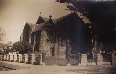
 Eltham District Historical Society Inc
Photograph, Tom Prior, Methodist Church, Eltham
Situated at 810 Main Road on the corner of John Street. The Church was surrounded by a picket fence and tall pine trees. The Church was built by George Stebbings in the 1850s and is an example of fine craftmanship. Formerly Wesleyan, Methodist then Uniting church; the foundations of the church building were constructed with stone from the walls of the first Eltham State Primary School (No. 209) building which collapsed in 1874 and were purchased by Robert David Taylor. The Reynolds/Prior Photograph Collection, Presented to the Eltham District Historical Society, 14 June 2006 by Ross McDonald. A second copy was also presented to the Andrew Ross Museum, Kangaroo Ground The Reynolds family were early settlers in Research. Reynolds Road is named after this family. RERVISED STATEMENT OF SIGNIFICANCE, CONTEXT, 2010 What is significant? The 1880 bichromatic brick church and the surrounding site to the title boundaries. The church is architecturally, historically, socially and spiritually significant to the Shire of Nillumbik. Why is it significant? The church is architecturally significant as a finely detailed example of a brick 19th century rural community church, one of only four in the Shire (Criteria E & B). The church is historically significant as an important link with the time when Eltham was a small, insular country settlement. Also for the historical evolution visible in the complex, with the modest 1880s church and larger red brick rear hall from the early 20th century as a reflection of population growth in the area (Criterion A). The church is historically, spiritually and socially significant because it has played, and continues to play, an important part in the spiritual and social life of the community (Criterion G). - Victorian Heritage Database The Reynolds family were early settlers in Research. The Reynolds/ Prior collection of photographs were taken by Tom Prior, the maternal uncle of Ivy Reynolds, around 1900 and the 60 photos in the album give a fine overview of many of the landmarks of Research and Eltham over 100 years ago. lvy lived in the family home for many years at 106 Thompson Cres Research. Ivy's father, Ernst Richard Reynolds and grandfather, Richard Reynolds, lived at the same address. Ivy's father Richard worked for Mr. Trail on his property in Research. Reynolds Road is named after the family. Mr Tom Prior (wife Eva) worked at the Melbourne zoo. He was very innovative and made his own camera, using the black cloth hood to exclude the light. The photographs are a reminder of the rural nature of Research and Eltham and its rich heritage. Black and white photograph mounted in an album, the Reynolds/Prior Photograph Collection, this being one of 53 reproduced black and white images of early Eltham."Methodist Church" reynolds prior collection, eltham, methodist church -
 Eltham District Historical Society Inc
Photograph, Liz Pidgeon, Hassall's Gallery Bazaar, 1215 Main Road, Eltham, 25 March 2014, 25 March 2014
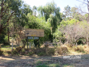
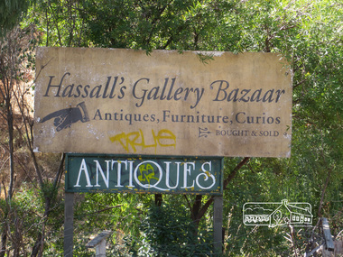
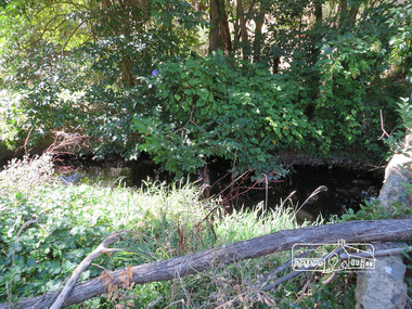
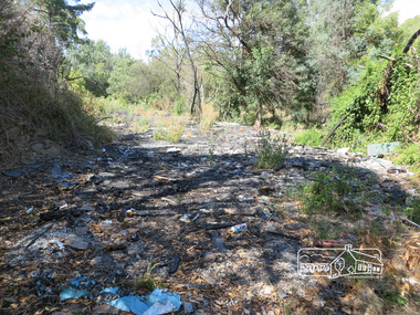
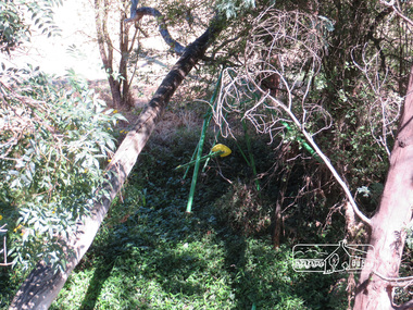
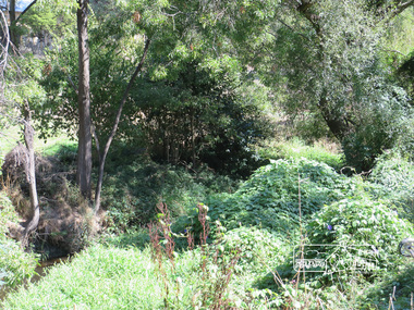
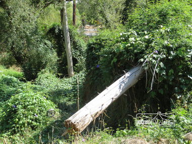
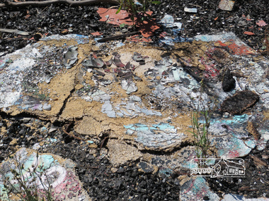
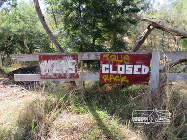
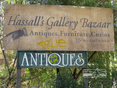
This is the site of the first roadside art gallery - Hassall's Roadside Gallery created by the artist son of an artist. Ian Hassall was the son of John Hassall who was among and may have been the first of the British poster artists. The gallery opened Saturday July 14, 1962 at 1215 Main road, Eltham by the director of the National Gallery of Victoria, Eric Westbrook. Situated on the left hand side of the main road, about a mile and a half beyond Eltham, towards Research, near Coleman's Corner at the intersection of Wattletree Road. The property has remnants of a stone quarry, probably for the purpose of gaining stone for local road making. Paintings were hung on screens and removed at night for safety. Large pedestals displayed sculpture and jewellery. All types of hand made art work was displayed. Access to the exhibition and grounds was slightly lower than the level of the road. They were encircled by a narrow little moat formed by a small tributary of the Diamond Creek accessed by a small well built stone bridge built by Ian Hassall with local stone. The Gallery later became known as Hassall's Gallery Bazaar antiques, furniture, curios bought and sold. It operated through to the early 1990s. The property has been derelict and neglected for some years. At one stage a shipping container sat near the entrance. This series of ten photographs illustrate the extent of the vegetation which has taken over the land, evidence of rubbish and a possible fire. In July 2017, planning permission was sought from the Shire of Nillumbik for buildings and works to construct a dwelling and associated vegetation removal. (source planningalerts.org.au)Born Digitaleltham, main road, hassall's gallery bazaar -
 Eltham District Historical Society Inc
Photograph, Liz Pidgeon, Hassall's Gallery Bazaar, 1215 Main Road, Eltham, 25 March 2014, 25 March 2014
This is the site of the first roadside art gallery - Hassall's Roadside Gallery created by the artist son of an artist. Ian Hassall was the son of John Hassall who was among and may have been the first of the British poster artists. The gallery opened Saturday July 14, 1962 at 1215 Main road, Eltham by the director of the National Gallery of Victoria, Eric Westbrook. Situated on the left hand side of the main road, about a mile and a half beyond Eltham, towards Research, near Coleman's Corner at the intersection of Wattletree Road. The property has remnants of a stone quarry, probably for the purpose of gaining stone for local road making. Paintings were hung on screens and removed at night for safety. Large pedestals displayed sculpture and jewellery. All types of hand made art work was displayed. Access to the exhibition and grounds was slightly lower than the level of the road. They were encircled by a narrow little moat formed by a small tributary of the Diamond Creek accessed by a small well built stone bridge built by Ian Hassall with local stone. The Gallery later became known as Hassall's Gallery Bazaar antiques, furniture, curios bought and sold. It operated through to the early 1990s. The property has been derelict and neglected for some years. At one stage a shipping container sat near the entrance. This series of ten photographs illustrate the extent of the vegetation which has taken over the land, evidence of rubbish and a possible fire. In July 2017, planning permission was sought from the Shire of Nillumbik for buildings and works to construct a dwelling and associated vegetation removal. (source planningalerts.org.au)Born Digitaleltham, main road, hassall's gallery bazaar -
Eltham District Historical Society Inc
Newspaper - Newsclipping, Nillumbik Mail, "A Memorial Avenue of Honour", A Journey in Time: A column about Nillumbik's history, Nillumbik Mail, 24 May 2000, p4, 2000
Main Road, Eltham, south from Brougham Street to Dalton Street, c.1911 View looking down Policeman’s Hill on Maria Street (Main Road) from near Brougham Street towards Dalton Street, site of the Avenue of Honour established in 1916-1917 in memory of the soldiers who served in the First World War, 1914-1918. At the bottom of the hill on the right is White Cloud Cottage, home of the Jarrold family, three women standing out front observing the photographer. The road passes over a culvert which runs to the west in front of the cottage. The cottage was originally located closer to the Diamond Creek but was subject to flooding. It was dragged by horse to the present site shown, which was chosen for the higher ground that had been created as a result of land fill being deposited here from the quarry further around the bend on Main Road (site of present-day Eltham Primary School carpark) where the stone had been quarried for building the State School in Dalton Street. Immediately at the end of the straight section of the main road can be seen the gas streetlamp in front of the Jarrold home and the pond at the bottom of Dalton Street. The cottage had previously been rented for use as a Police Station / residence prior to the building of the permanent police house and station at the corner of Maria and Brougham streets in 1859. At the time of collection of photos for the centenary of the Shire of Eltham (1971) the cottage was owned by the Skipper family and remains in the family to present day (2021). On the left is the Grant house on the corner of Main Road and Dalton Street now the present-day site of Eltham Clinic. Photographer: J.H. Clark John Henry Clark was the youngest of three boys born to William Henry Clark (1823-1877) and Maria White (1843-1914). He and his brothers, William Charles Clark (1872-1945), Clement Kent Clark (1874-1912) operated a photography business (Clark Bros.) from 25 Thomas Street, Windsor near Prahran during the period c.1894 to 1914. Following death of Clement in September 1912 and their mother in 1914, the Clark Bros business appears to have dissolved, the premises demolished, and a new house was under construction in 1915. John set up business independently in 1914 operating out of 29 Moor Street, Fitzroy where he is registered in the 1914 and 1915 Electoral Rolls. By 1916 John had relocated to Eltham where he continued his practice as a photographer and took many of the early images around the district of Little Eltham. Around 1930 John changed professions and opened a small cobbler's shop in 1931 near the pond opposite Dalton Street adjacent to the Jarrold family cottage. He never married and continued his profession as a bootmaker from this little shop, maintaining a close relationship with Mrs Jarrold for the rest of their lives. His bootmaker shop remains today beside the Whitecloud cottage and is one of only three remaining shops in the area from the early 20th century. There are a couple of images of Eltham taken by Clark Bros. in the Eltham District Historical Society collection, one such example being Hunniford’s Post Office with Miss Anne Hunniford out front (EDHS_00140 - marked on the back of the print, Clark Bros., 25 Thomas St. Windsor), which would date this image between c.1894 and 1914. Other early images of Eltham taken by John Henry Clark are marked on the face “J. H. Clark Photo” and it is assumed these are dated between 1914 and 1930. It is noted that the Grant of Probate for John H Clark of Eltham South dated 5 April !957 (513/387) records his occupation as "X Photographer".Newsprint pageNillumbik Mail publication details; Edition 4, 24 May 2000, p4dalton street, avenue of honour, eltham clinic, gas lamp, grant house, j.h. clark photo, jarrold cottage, jarrold family, main road, shire of eltham pioneers photograph collection, white cloud cottage -
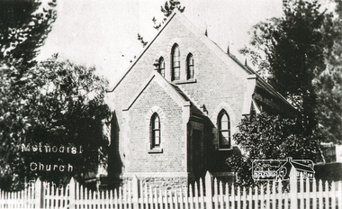
 Eltham District Historical Society Inc
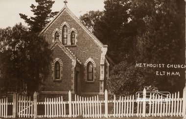
Photograph, Eltham Methodist Church, 1909, 1909
Situated at 810 Main Road on the corner of John Street. The Church was surrounded by a picket fence and tall pine trees. The Church was built by George Stebbings in the 1850s and is an example of fine craftmanship. Formerly Wesleyan, Methodist then Uniting church; the foundations of the church building were constructed with stone from the walls of the first Eltham State Primary School (No. 209) building which collapsed in 1874 and were purchased by Robert David Taylor. REVISED STATEMENT OF SIGNIFICANCE, CONTEXT, 2010 via Victorian Heritage Database What is significant? The 1880 bichromatic brick church and the surrounding site to the title boundaries. How is it significant? The church is architecturally, historically, socially and spiritually significant to the Shire of Nillumbik. Why is it significant? The church is architecturally significant as a finely detailed example of a brick 19th century rural community church, one of only four in the Shire (Criteria E & B). The church is historically significant as an important link with the time when Eltham was a small, insular country settlement. Also for the historical evolution visible in the complex, with the modest 1880s church and larger red brick rear hall from the early 20th century as a reflection of population growth in the area (Criterion A). The church is historically, spiritually and socially significant because it has played, and continues to play, an important part in the spiritual and social life of the community (Criterion G).Sepia postcard of Eltham Methodist Church, 1909eltham, methodist church, church, state school no. 209, eltham state school, robert david taylor, eltham uniting church, uniting church, wesleyan church