Showing 405 items
matching tambo
-
 Narre Warren and District Family History Group
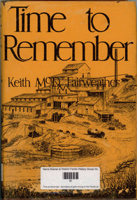
Book, Keith McDonald Fairweather, Time to remember : the history of gold mining on the Tambo and its tributaries, 1975
Contains stories of old mines in the area in great detailnon-fictionContains stories of old mines in the area in great detailtambo river valley, cassilis gold mining co, gold mines, shire of omeo -
 Lakes Entrance Historical Society
Memorabilia - Tambo Shire badges, Shire of Tambo 100 yr Medallions X 5
civic mementoes, souvenirs -
 Lakes Entrance Historical Society
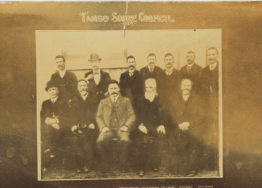
Postcard - Tambo Shire Councillors, 1907
Also a second photograph of councillors which is very faded 05387.1Sepia toned photograph of twelve Tambo Shire Councillors 1907 H J Howlett, DH Phee, RW Stirling Sec, HW Sechussen, J Duke, H Ross, A MeRae, D T King, D McRae, CB Irving Pres., D Williams, JD Henderson Bruthen VictoriaTambo Shire Council 1907local government -
 Lakes Entrance Historical Society
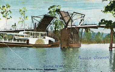
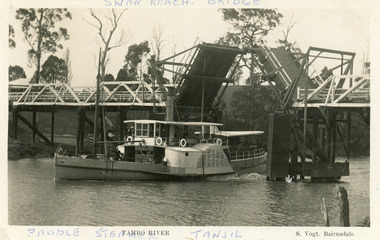
Photograph - Bridges, V S M Series, 1920 c
Hand tinted postcard showing Paddle Steamer 'Tanjil' passing upstream under the open Swan Reach Bridge on the Tambo River, East Gippsland, Victoria.New Bridge over the Tambo River Swan Reach Paddle Steamerships and shipping, waterways, bridges -
 Lakes Entrance Historical Society
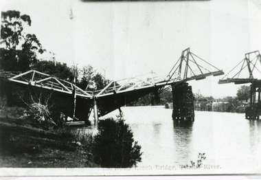
Photograph - Bridges, Bulmer H D, 1925
Swan Reach Bridge collapsed 10.00 am 16 November 1925Black and white photograph showing collapsed bridge over the Tambo River, bridge collapsed at eastern end. Photo looking downstream. Two people on landing on far right bank behind right hand bridge pylon. Thick vegetation on bank. Swan Reach VictoriaSwan Reach Bridge on the Tambo Riverwaterways, boats and boating, disasters -
 Lakes Entrance Historical Society
Postcard - P.S. Tanjil, Vogt, Stanley, 1920 c
Two copies existBlack and white postcard showing P S Tanjil passing downstream under Swan Reach Bridge on Tambo River, East Gippsland, Victoria.Paddle Steamer Tanjil Tambo River Swan Reach Bridge. S. Vogt Bairnsdaleships and shipping, waterways, bridges -
 Lakes Entrance Historical Society
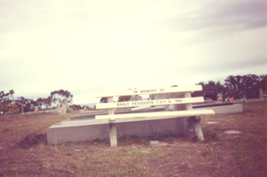
Photograph - Cemetery Lakes Entrance Victoria, Vera Bennett, timber seat in the cemetery Lakes Entrance Victoria, 1991
donated by the Tambo Shire Historical Society Colour photograph of the timber seat donated by the Tambo Shire Historical Society in memory of early residents in the cemetery Palmer Road Lakes Entrance Victoriahistorical society, historic sites, cemeteries, trees -
 Orbost & District Historical Society
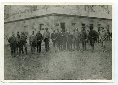
black and white photograph, late 19th century - early 20th century
Probably taken 1890's before Orbost was separated from Tambo. The Shire of Tambo was a local government area about 320 kilometres east of Melbourne. The shire covered an area of 3,506.86 square kilometres and existed from 1882 until 1994. Tambo was first incorporated as a shire on 6 January 1882, splitting away from the Shire of Bairnsdale. On 30 May 1892 it lost three-quarters of its land area when the Shire of Orbost was incorporated. A small amount was re-annexed as Cunninghame Riding on 3 January 1913. On 2 December 1994, the Shire was abolished, and merged with the City and Shire of Bairnsdale, Shire of Orbost, most of the Shire of Omeo and the Boole Boole Peninsula from Shire of Rosedale into the Shire of East Gippsland. ( more information Newsletter July 2010). This photograph is of Tambo Shire Council meeting at Faithful's Hotel, Nowa Nowa. It includes Snowy River Riding councillors. Mary Stirling, wife of Shire Secretary Thomas Telfer Stirling, took over the Nowa Nowa Hotel from Moses Faithful in 1895. Photograph includes: John Butter BESLEY, John William BORLAND, Charles Begg IRVINE, William J. LAMBOURN, James LARKIN, Ronald McDOUGALL, Donald McRAE, William ROADKNIGHT jnr., David WILLIAMS, James CAMERON, Charles Henry GROVE. (info. John Phillips) This item is associated with the Tambo Shire Council, a local government which no longer exists.A black / white photograph of a group of men standing in a line outside a large timber building.on back - "Tambo Shire Council . Meeting at Nowa Nowa - Stirling's Hotel"tambo-shire-council faithful's-hotel-nowa-nowa local-government -
 Lakes Entrance Historical Society
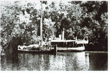
Photograph - S. S. Lady Harriet, 1908
1 x Black and white photograph copied from a book 9.5 x 14.5.Black and white photograph showing S S Lady Harriet at the cliffs on the Tambo river. The Lady Harriet barge on left of S S Harriet, well vegetated cliff behind the vessels. Swan Reach Victoria1908 S S Lady Harriet at cliffs in Tambo River and her barge (on back)jetties, ships and shipping, waterways, topography -
 Lakes Entrance Historical Society
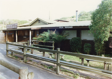
Photograph - Tea Room, Tambo Shire, 1980c
This is the before paired photograph used in the 150 year Lakes Entrance 1858-2008 display.|The after paired photograph number is 01544.1|Also one 12 x 16 framed photograph used in room display.Colour photograph of the kiosk on the hummocks. It shows the recently renovated and extended kiosk and garden, nestling beside the scrub covered sand hummock. Rustic picnic tables and seats inside garden grounds. Lakes Entrance Victoriawaterfront, restaurant -
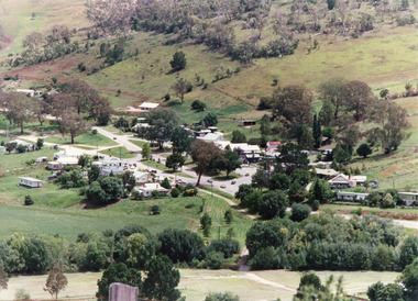
 Lakes Entrance Historical Society
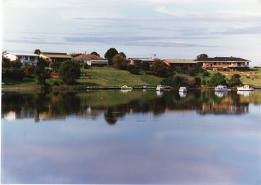
Photograph - Lakes Entrance, Tambo Shire, 1994 c
Also second identical copyColour photograph of a section of the North Arm adjacent to Ferndale Parade, shows the rear view of six houses, five small boats moored at lake edge. Lakes Entrance Victoriajetties, houses, waterways, boats and boating, township -
 Lakes Entrance Historical Society
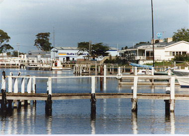
Photograph - Metung Hotel, Tambo Shire, 1994 c
Also second identical copyColour photograph of the waterfront adjacent to Metung Hotel, showing jetties, hotel and Bulls Cruisers. Metung Victoriajetties, boats and boating, waterfront, hotels -
 Lakes Entrance Historical Society
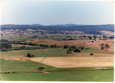
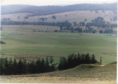
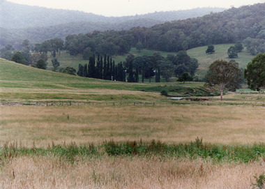
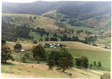
Photograph - Mossiface Flats, Tambo Shire, 1994
Also second identical copyColour photograph of the Mossiface Flats, near Bruthen, shows paddocks of the rich river flats, timbered foothills in the distance, with mountain range behind. Some paddocks have been mown for grass hay. Farm buildings in foreground and background. Dam in foreground. Bruthen Victoriaanimals, agriculture, vegetation, topography -
 Lakes Entrance Historical Society
Photograph - Sarsfield Flats, Tambo Shire, 1994 c
Also second identical copyColour photograph of Sarsfield Flats. Distant view of cattle grazing and farm buildings, foothills in background, and glimpse of mountains. Pine trees in the foreground. Bruthen Victoriaagriculture, topography -
 Lakes Entrance Historical Society
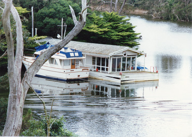
Photograph - Box's Creek, Tambo Shire, 1994
Also second identical copyColour photograph of a holiday house, built over the water at Box's Creek, a motor cruiser moored beside the house. Metung Victoriawaterways, tourism, boats and boating -
 Lakes Entrance Historical Society
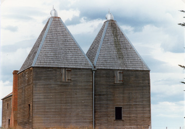
Photograph - Hop Kiln, Tambo Shire, 1994
Also second identical copyColour photograph of the hop kilns at Mossiface, shown buildings and shingle roof in good order. Mossiface Victoriabuildings, historic sites -
 Lakes Entrance Historical Society
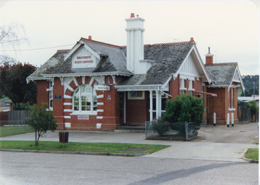
Photograph - Postal Office Bruthen, Tambo Shire, 1994 c
Also second copy identicalColour photograph of Post Office, shows a brick building, slate covered, gable roof, decorative brickwork around windows, tall chimneys with chimney pots, decorative tiles on roof ridges. Commonwealth Savings Bank sign under window. Bruthen Victoria buildings, postal services -
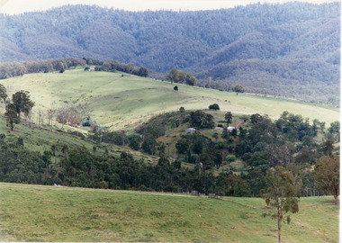
 Lakes Entrance Historical Society
Photograph - Timbarra, Tambo Shire, 1994 c
Colour photograph of grazing country in the Timbarra region, showing well grassed paddocks in foreground farm buildings in valley wooded foothills in background. Timbarra Victoriaagriculture, primary industry, animals -
 Lakes Entrance Historical Society
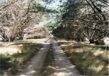
Photograph, Tambo Shire, 1994 c
Also second identical copyColour Photograph of a typical farm driveway, shows a long driveway bordered with cypress trees. Nicholson Victoriaroads and streets -
 Lakes Entrance Historical Society
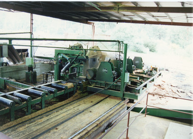
Photograph, Tambo Shire, 1996 c
Also second identical copyColour photograph taken from inside sawmill, showing saw bench and machinery. Nowa Nowa Victoriamachinery -
 Lakes Entrance Historical Society
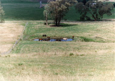
Photograph, Tambo Shire, 1994 c
Also second identical copyColour photograph of a rural view near Buchan, shows five horses in and around a dam, farming building in distance glimpsed through trees. Bruthen Victoria topography, agriculture -
 Lakes Entrance Historical Society
Photograph - Buchan, Tambo Shire, 1994 c
Also second identical copyColour photograph of the township of Buchan, taken from a high point above the town which is situated in a valley with hills rising on all sides. Buchan Victoriatownship, topography -
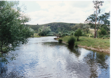 Lakes Entrance Historical Society
Photograph - Buchan River, Tambo Shire, 1994 c
Colour photograph of the Buchan river, showing stream flowing between low banks, hills rising in distance. Buchan Victoria topography, waterways -
 Lakes Entrance Historical Society
Photograph - Buchan Station, Tambo Shire, 1994 c
Also second identical copyColour photograph of Buchan Station, shows farming buildings situated among trees, both cultivated and uncultivated paddocks around property, forested hills in background. Buchan Victoriaagriculture, animals, topography -
 Lakes Entrance Historical Society
Photograph, Tambo Shire, 1994 c
Also second identical copyColour photograph of grazing country near Buchan, showing cattle on grassy flat rugged rocky hill in background. Buchan Victoriavegetation, primary industry -
 Lakes Entrance Historical Society
Photograph, Tambo Shire, 1994
Also second similar copyColour photograph taken at The Basin, showing hilly farmland, dense forest on ranges in distance. Buchan Victoriatopography, vegetation -
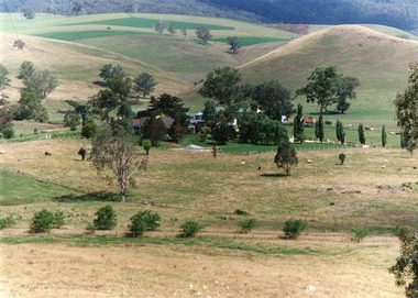
 Lakes Entrance Historical Society
Photograph - Gillingal Station, Tambo Shire, 1994 c
Also second identical copyColour photograph of Gillingal Station, showing the farm buildings situated on a hillside and surrounded by rising hill country and fertile valleys, cattle grazing in home paddock. Buchan Victoriaagriculture, primary industry -
 Lakes Entrance Historical Society
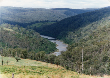
Photograph - Snowy River, Tambo Shire, 1994
Also second identical copyColour photograph of the Snowy River near The Basin, showing a river flowing between rocky banks, densely forested hills rising on both sides and into the far distance. Buchan Victoria topography, waterways -
 Lakes Entrance Historical Society
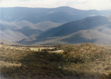
Photograph - Suggan Buggan, Tambo Shire, 1994 c
Also second identical copyColour photograph of the scenery in Suggan Buggan, showing very heavily forested mountainous country, a small area of cleared land centre left foreground. Suggan Buggan Victoriasettlement, agriculture, topography -
 Lakes Entrance Historical Society
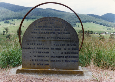
Photograph - Pioneer Memorial, Tambo Shire, 1994 c
Also second identical copyColour photograph of the roadside Pioneer Memorial at Murrindal near Buchan, Victoria.memorials, pioneers