Showing 144 items
matching taylor frank
-
 Federation University Historical Collection
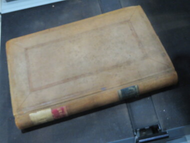
Book - Ledger, Ballarat School of Mines Assay and Analysis Ledger, 1887-1890, 1887-1890
The Ballarat School of Mines had a 'Model Mine' that was used to teach students. Practical work was undertaken for a fee, supervised by laboratory superintendents. Copies of assays undertaken are compiled together in this book. Leatherbound ledger with transfer copies assay reports from the Ballarat School of Mines. Those seeking assaying work from the Ballarat School of Mines are listed in alphabetical order in the front of the ledger. The ledger contains 543 pages. .2) Foolscap assay report on foolscap Ballarat School of Mines letterhead, and signed by Alfred Mica Smith, Superintendent of Laboratories. The report was on eight samples of Quartz submitted by R.C. Morgan, Scotts, Hotel, Melbourne .3) Assay report on Ballarat School of Mines letterhead, dated 14 August 1985, and signed by Andrew Berry, Registrar. The assay was supervised by Professor Alfred Mica Smith, and undertaken for James Burke, Broken Hill, New South Wales. .4) Assay report on Ballarat School of Mines letterhead, dated 18 August 1988, and signed by Alfred Mica Smith, Superintendent of Laboratories. The assay was undertaken on samples of Limonite submitted by James Burke and others, Broken Hill, New South Wales. The report includes information the the Ballarat School of Mines museum and the search for geological specimens from all Australian colonies for the collection. .5) A 'rough' assay report on samples of stone submitted by H. Major Senr, Wilcannia, New South Wales. 5) A 'rough' assay report on sample quartz drillings from quartz reef submitted by H. Morris, Egerton, and an sample of quartz and pyrites for determination by Professor Krause submitted by R.M. Serjeant. ballarat school of mines, a.c. allan, brittania g.m. co., s. body, black horse company, john m. bickett, william bell, james barker, w. bliss, w. bailey, william barrou, w.h. batten, w. bechervaise, band and albion, budd bros, charles barker, i. cahir, a. chamber, w. cahill, james coglan, d. clarke, a.w. dobbie, john dosett, john dunstan, j.a. evans, l. eggleton, charles forbes, d. fitzpatrick, e. ford, michael goold, j. graham, john greenwood, james hayes, ed hardy, arthur harvey, george hodges, john hall, jubilee gold mining company, krause, luplau, lempiere, mt lyell co, john law, ed meadway, john murray, j.h. middleton, c.m. miles, m. muir, e. mcmillan, w. mcdougall, c. napier, w.r. nicholls, napier freehold, w.b, ochiltree, oakleigh gold mining company, dr pinnock, c. quin, james ross, c.b. retallack, e. rowlands, royal standard, linton, frank rabling, william russell, charles soloman, f. selby, w.j. scott, sulieman pasha co, south clunes united, h.w. sinclair, george selby, e.h. schroeder, horsham, e.w. spain, c.h. sheary, sir henry loch gold mining company, a. sutherland, saxon consols, j.b. triggs, h. townsend, harold turnley, c. taylor, melbourne, c. thorpe, a. vandenberg, charles walker, charles wilson, thomas wellington, a. wynne, r. warne, e. wattis, john wood, walter warner, armidale, c. winterbottom, w.l. willliams, j.c. young -
 Federation University Historical Collection
Booklet, Ballarat School of Mines Annual Report, 1984, 1984
New courses at the Ballarat College of Advanced Education in 1984 included Health Education and Psychology.Red A4 booklet - the Ballarat College of Advanced Education. ballarat college of advanced education, annual report, oppy, ian gordon, david alexander, george pell, derek woolley, g.r. hendy, peter taylor, roy schrieke, peter fryar, frank hurley, peter swan, ken clements, geoff hendy, librarianship, john howard, john siddons, norman barling, batty fitzgerald, micro-teaching programmes, martin westbrooke, lindsay pattenden, stafford mcknight, geoff biddington, denise else, computer centre, health service, union buliding, coates centre, student residences, art acquisitions committee, greg daly, john mildren -
 Federation University Historical Collection
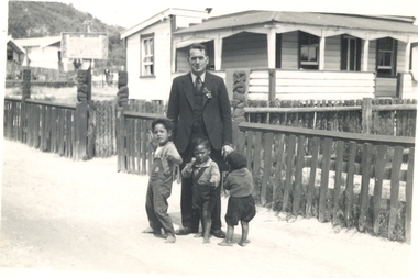
Photograph - black and white, Taylors' Super Snaps, Frank Wright at Rotorua, New Zealand, 1940, Feb 1940
Frank Wright was a renoun resident of Smeaton, where he was born on 2 August 1901. He lived at Laura Villa, and attended Smeaton State School. His father William was a gold miner and his mother's name was Sarah. Their family won many singing and instrumental awards. Frank was tutored by Percy Code and was awarded a gold medal for the highest marks in the ALCM examinations in the British Colonies at the age of seventeen years. He became the Australian Open Cornet Champion by the age of eighteen. A year later, Frank conducted the City of Ballarat Band, and later the Ballarat Soldiers’ Memorial Band. He formed the Frank Wright Frisco Band and Frank Wright and his Coliseum Orchestra. These bands won many South Street awards, and Frank as conductor won many awards in the Australian Band Championship contest. In 1933 Frank Wright sailed to England to conduct the famous St Hilda’s Band and was later appointed Musical Director of the London County Council, where he organized many amazing concerts in parks, in and around the London district. He was made Professor of Brass and Military Band Scoring and conducted at the Guildhall of Music and Drama. Frank was often invited to adjudicate Brass Band Championships around Europe, in Australia, including South Street and in New Zealand. The Frank Wright Medal at the Royal South Street competition is awarded to an individual recognized as making an outstanding contribution to brass music in Australia. He died on 16 November 1970.Black and white photograph of a man dressed in a dark suit standing on a made road with three little boys around him. Behind him is a timber house enclosed by a wooden fence. The fence posts and gate posts are carved in the Maori tradition. The man is Frank Wright and the place is Rotorua, New Zealand.Written in pencil on back - At Rotorua, Feb 1940frank wright, musician, adjudicator, brass bands, rotorua, maori carved fence posts -
Federation University Historical Collection
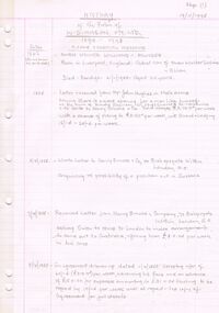
Book - Ledger, Ballarat School of Mines Minute Book, 1942-1946, 03/03/1942-20/03/1946
The Ballarat School of Mines was established in 1870 and was the first School of Mines in Australasia. Blue hard covered book with brown leather spine and corners. pg 4 - Farewell for Albert W. Steane pg 9 - Instruction in Electrical Engineering pg 30 - The late Cr M. Martin pg 38 - Caretakers Duties pg 40 - The late Cr F. Barrow pg 43 - John Brittain Telescope pg 43 - Martha Pinkerton Bequest pg 66 - Resignation of Albert E. Williams pg 85 - N. Whiteside and Civil Engineering Course pg 128-130 - Technical Education pg 193 - Proposed new buildings pg 272 - Retirement of J.M. Sutherland pg 280 - Proposed change of name to school pg 297 - Woolclassing Room pg. 342 - pg 353 - D. Taylor Kellock pg 353 - Resignatin of Miss Grigg pg 367 - Dr Pern's Collections of Aboriginal Artefacts pg 377 - Inmates of Ballarat Orphanage pg 356 - Ballarat School of Mines Museum contents Loose - Resolutions Passed by Technical Schools' Association of Victoria, October, 1942, with the Minister's Replies.Pg 367 - "Dr Pern's Collection Cr Lederman reported on the proceedings of the special committee meeting held on the 19th February. At that meeting it was suggested that the Ballarat Historical Society might consider transferring their collection to the Museum. It was decided that any expert from Melbourne be invited to come to Ballarat for the purpose of inspecting the mounted birds, which in many instances were falling to pieces, and recommending the best way of dealing with them."m. grigg, t.h. trengrove, building plans, john brittain telescope, new workshops, t. barrow, a.w. steane, martha pinkerton, ballarat school of mines museum, sydney pern, pern collection, ballarat orphanage, thomas aggett, william aggett, sebastian fumberger, peter hogg, ronald irving, eric jackson, ray lear, ken mason, john birch, william gleeson, robert gleeson, robert guyas, ronald holmes, albert king, stuart smith, alan snell, martha pinkerton scholarship, frank pinkerton scholarship, thomas trengrove, d. taylor kellock, architecture course -
 Federation University Historical Collection
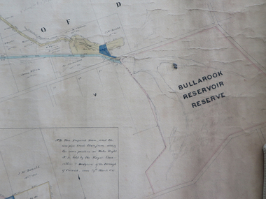
Plan, Creswick Water Supply from Bullarook to Creswick, 02/10/1869
... frank rivers w.r. taylor j. and m. mccormack j. mcdonald richard ...Probably gazetted on 12 April 1872 (pg 737)Large horizontal paper plan glued in three sections to a linen backing. Coloured plan shows pipe and rack track from the Bullarook Reservoir to Albert Street, Creswick. Attached with ribbon top left are twelve pages giving bearing and lengths / descriptions of pipe and rack track. Five information boxes drawn along the bottom of plan gives extra information where pipe passes through private properties. Main heading 'Plan of Creswick Water Supply / scale eight chains to an inch / County of Talbot / Parish of Creswick'. Calculations and hand written notes in ink and pencil also on plan. Verso 'Dean Reservoir'. Signed and dated.creswick, water supply, bullurook reservoir, dean, bush inn, hesken, rivers, warner, taylor, gillard, mccormack, mcdonald, brown, naples, humbug hill sluicing co, frank rivers, w.r. taylor, j. and m. mccormack, j. mcdonald, richard brown, c. naples -
 Federation University Historical Collection
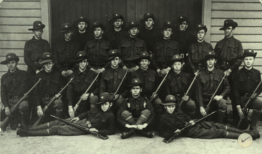
Photograph - Photograph - black and white, Ballarat Junior Technical School Cadet Team, 1916, 1916
Francis Davis was the only former student of the Ballarat Junior Technical School to die during World War One. "Francis Davis was accorded a full military funeral, firing party, bugler and pallbearers. The coffin was draped in the Union Jack and surmounted in several beautiful wreathes sent from his brother 2/A.M. E.H. Davis (A.F.C Leighterton), officer of the A.F.C. Leighterton, Gloucester, Cadets of A.F.C. and many other personal friends of the deceased. The "Last Post" was sounded at the graveside, and the Rev. Major K.D. Norman C. of E. A.I.F. officiated. The grave was to be turfed and an oak cross erected by the A.I.F. London. Administrative Headquarters A.I.F. London were represented at the funeral. (http://naa12.naa.gov.au/scripts/Imagine.asp?B=1858392, accessed 24 January 2014.) According to Neil Leckie, Manager of the Ballarat Ranger Military Museum: * Originally 12 – 14 year olds went to Junior Cadets attached to their school. * From age 14 – 17 they were Senior Cadets attached to the local militia unit. * After 1 July of the year a Cadet turned 18, the Cadet left the Senior Cadets and became a member of the Citizen Military Force. * In October 1918 the AIF, Militia and Cadets were renamed to give some connection to the AIF battalion raised in the area. Ballarat saw: 8th Australian Infantry Regiment comprising: * 8th Battalion AIF renamed 1st Battalion 8th Australian Infantry Regiment * 70th Infantry Militia renamed 2nd Battalion 8th Australian Infantry Regiment * 70th Infantry Cadets renamed 3rd B, 8th Australian Infantry. 39th Australian Infantry Regiment comprising: * 39th Battalion AIF renamed 1st Battalion 39th Australian Regiment * 71st Infantry Militia renamed 2nd Bn, 39th Australian Infantry Regiment * 71st Infantry Cadets renamed 3rd Bn, 39th Australian Infantry Regiment Prior to the reorganisation in 1918 the 18th Brigade was the 70th, 71st and 73rd Infantry. It is thought that the 18th Brigade Cadet units in 1920 were those that came from the old: * 69th Infantry (Geelong/Queenscliff) * 70th Infantry (Ballarat/Colac) * 71st Infantry (Ballarat West) * 72nd Infantry Warrnambool) * 73rd Infantry (NW Vic) The next name change came in 1921!Black and white photograph of a group of school boys in army uniform. They are members of the Ballarat Junior Technical School Cadets. Back Row: D.O. Taylor, Albert E. Williams, B. Burrows, J.B. Hobba Standing: Francis Davis, Miller, A. Burge, P. [Peter] Chatham. J. Minster, H. Witter, H. Siemering Kneeling: T.G. Wasley, Alan Riley, A.H. Hoskin. N.C. Carmichael, Harold G. Wakeling, T. Rees, W.H. Shattock, F.N. Gibbs Front: S.J. Chambers, F.J. Procter, Charles H. Beanland francis davis, frank davis, ballarat junior technical school cadets, cadets, d.o. taylor, albert e. williams, b. burrows, j.b. hobba, miller, a. burge, p. chatham, j. minster, h. witter, h. siemering, t.g. wasley, a. riley, a.h. hoskin, n.c. carmichael, harold wakeling, t. rees, w.h. shattock, f.n. gibbs, s.j. chambers, f.j. procter, charles h. beanland, alan riley -
 Federation University Historical Collection
Magazine - Booklet, Ballarat School of Mines Students' Magazine, 1938, 1938
School Council, Members of Staff, Magazine Committee, List of Full Course Students 1938, Full Course Commercial Students, Editorial, Personal Column, Obituary - Roy S. Hall - F. J. Martell, S.M.B Old Boys' Association, The Literary Society, Centenary Jottings, Fumes from the Lab, Broken Hill, News from Papua, Sidelights on the B.H.P. Cadet Training Scheme, Arts & Crafts Gossip, Sport, Commercial Notes, The Junior Techs, Junior Technical SportingBlack soft covered magazine with yellow font, green and white images. 64 pages including advertisements. Artworks * Lino cut - By Maureen McRae * Lino Cut - By B. Delima * Lino Cut - By Bessie Martin * The dog you's like to kick - By Gordon Yorke * Harry - By Ernest Gribble * Digger - By Ernest Gribble * Lino cut - By Gordon Yorke * Our little girl - By Dorothy Woolcock * Miss W - By Ernest Gribble * Joan - By Ernest Gribble * Roma - By Gladys Bilney * Doing art for t'arts sake - By Gilda Gude * Una - By Dorothy Woolcock * My Bill - By Dorothy Woolcock * The Sec. - By Ernest Gribble * Hassell - By Dorothy Woolcock * Chief Engineer - By Dorothy Woolcock * Rusty - By Ernest Gribble * Lino Cut - By Jeff Wilkinson * Dick - By Dorothy Woolcock * Goosey - By Ernest Gribble * Pen Drawing - By Dorothy Woolcock * Parking 1 - By Max Coward * Miss King - By Dorothy Woolcock * Goal Umpire - By Ernest Gribble * To Prep Girls - Joe - By Ernest Gribble * Dreamy Dolan - By Ernest Gribble * Lino Cut - By Max Coward * Norma - By Dorothy Woolcock * Lino Cut - By A. Janetski * Dorothy - By Patsy Walsh * Jean - By Dorothy Woolcock * Lino Cut - By Joy Martin * Lino Cut - By Max Coward and A.2., * Ben - By Bob McHutchison * Polly - By Ernest Gribble * Dobber - By Ernest Gribble * Francies - By Ernest Gribble * Ad a line not a bite - By Dorothy Woolcock * Dulcie - By Dorothy Woolcock * Joan - By Ernest Gribble * Kitty - By Bob McHutchison * Stumpy - By Elva Brimacombe * Pegleg - By Dorothy Woolcock * Fat - By Gladys Bilney * Dawn - By Dorothy Woolcock * Joy - By Ernest Gribble * Nipper - By Ernest Gribble * Mac - By Ernest Gribble * Puss - By Bob McHutchison * Tinted Lino Cut - By W. Edward * Lino Cut by G.Day ballarat school of mines, magazine, maureen mcrae, b. delima, j. woolcock, herbert j. trevenan, n. palmer, olwyn williams, gordon yorke, bob mchutchinson, w. edward, keith heriot, sylvia wyres, jeff wilkinson, peter richards, d. gordon, f. morris, mr proctor, ernest gribble, dr. j. r. pound, muriel boyd, george downing, roy s. hall, f. j. martell, d. v. shore, ken wilkie, eoin macdonald, g. berriman, dorothy woolcock, russell h. s. ewins, v. e. greenhalgh, max coward, shelia moss, frank t. jelbart, neil crouch, graham white, mr cornell, francis hollioke, k. vaughan, david j. jelbart, arthur g. veale, bill walters, richard menhennett, james redford, w. monteith, mr hillman, john t. graham, james w. thomas, keith. walter, james m. martin, lyle s. dimsey, jean birch, margaret turner, lesley stapleton, marjorie day, una kersey, jean lonie, coral robertson, norma rowe, jean bridges, jean cox, a. janetski, d. ditchfield, j. harrison, gladys james, j. brimacombe, sheila moss, r. mathews, joy martin, joan ellsworth, e. salter, a. spence, m. may, f. coulson, i. clow, h. tonkin, l. taylor, s. harris, k. gingell, g. jones, william t. paterson, f. harland, w. harrison, j. pike, a. mcmillan, m. lee, e. mccann, j. harris, a. clack, f. osborne, e. stephens, s. nicol, d. eltringham, j. hosie, v. burt, w. rowe, wm. c. edward, j. donald, m. cox, n. dalton, gladys bilney, gilda gude, patsy walsh, elva brimacombe, g. day, francis hollyoake, centenary, betty brown, alan nye, victor greenhalgh, alan gilpin, george edward, e.h. schache, john dulfer, max bayley, eric rumpff, henry kum yuen, fred j. martell, old boys' association, literary society, j.a. wilkie, cyril callister, g. yorke, broken hill, papua, e. macdonald, j. wilkinson, bhp cadet training scheme, g.r. crouch, salt lake city, utah, photography, photographic class, r.h.e. ewins, f. jelbart, n. crouch, g. white, f. hollioake, p. richards, d. jelbart, a. veale, w. walters, e. gribble, r. mchutchison, r. menhennett, i. redford, k. heriot, j. graham, j. thomas, r. ewins, k. waller, j. martin, j. king, bena lamb, j. birch, m. turner, l. stapleton, m. day, u. kersey, j. lonie, c. robertson, n. rowe, j. bridges, m. mcrae, o. williams, j. cox, g. james, s. moss, b. martin, junior technical school old boys' association, des marks, cornell's little liver pills, ballarat wattle tea rooms, the modern dairy -
Federation University Historical Collection
CD-ROM, Speech by Geoffrey Blainey on the Occasion of the 140th anniversary of the Establishment of the Ballarat School of Mines, 2010, 2010
Geoffrey Blainey was foundation Chancellor of the University of Ballarat (later Federation University Australia). The talk has been transcribed by Julie Prowse in January 2018.CD-ROM where Vice-Chancellor David Battersby introduced Frank Hurley of the Ballarat Mechanics; institute to speak, followed by Professor Geoffrey Blainey who speaks on "When Ballarat was more important that Canberra". Included information on Ballarat Mechanic's Institute Library. Mr Smith, fruiterer of Wendouree; Nathan Speilvogel, author of 'Gumsucker on the Tramp'. Gumsucker was an abbreviaton for a Victorian. Ballarat in 1901-1910, Alfred Deakin, Canberra. 57.33 minutes long.geoffrey blainey, david battersby, frank hurley, university of ballarat, ballarat mechanics' institute, ballarat, charlie taylor, nathan spielvogel, edmond barton, alfred deakin, canberra, david mcgrath, robert menzies, anniversary -
Federation University Historical Collection
Booklet - Newsletter, University of Ballarat ISB News, 1996-1998
Six volumes of the University of Ballarat Information Services Branch.unitversity of ballarat, information services branch, computer support, remote connection, electronic copyright, print centre, frank russell, e.j. barker library, computer centre, student residences, email, gerry anderson, bill hitchens, julian callahan, lance duncan, junk email, gary walker, netconnect, cameron mcdonald, innopac, help desk, library catalogue networked, travan greenbank, aaron hill, walter taylor, rupert russell, stuart fraser, benjamin stickland, jacqui macmillan, paul mensch, computer services, digital printer, john stojanovski, electronic newspapers, pam goodfellow, remote access, sovereign hill, virtual museum of gold, heather mays -
 Federation University Historical Collection
Document - Documents - Reports, Notes for Staff: Ballarat Institute of Advanced Education, 1972
Ballarat Institute of Advanced Education is a predecessor or Federation University3 typed documents from the Ballarat Institute of Advanced Education 1972. .1 Notes for Staff including progress, welcome, administration, new staff appointments, student enrollments etc. .2 Notes for Staff including staff changes, new courses, past principals, enrollments, staff list etc. .3 Notes for Staff including a fourth university, tertiary finance, academic board etc. V. Barry written on top right hand corner of .1 & .2ballarat institute of advanced education, notes for staff, verna barry, e.j. barker, r.p. martin, b.r grainger, j.a.sykes, colin kline, roy schrieke, mark beverlander, ken clements, bill hitchins, lindsay pattenden, tom norwood, bill durant, student union, student residences, coburn and associates, jackson and walker, s.j. weir, mt helen library, albert medal, r.w. richards, anne mills, david ward, geoffrey lyle, rocky hazlett, ray martin, dave jelbart, zig plavina, allan ballard, pat hope, henry moritz, helen ross, roger bodenham, arch mckinnon, frank hogarth, harvey hooper, geoff barrell, jim thyer, john collier, lenore cox, fourth university, craftsmanship certificates, jenny burrell, jennifer hullick, r.w richards death, danny mullins, jack crosbie, harry nicholls, len taylor, library, graham hawley, jack barker -
 Ringwood and District Historical Society
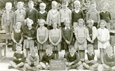
Photograph, Ringwood State School- Grade 1A, 1948
Black and white photograph"Written on back of photograph" Back Row- L to R: Douglas Hume, Ian Sharp, ?, Alan Telfer, Tom Williams, John Munday, Ken Parnell, Bruce Fletcher, Ray Taylor. 2nd Row- L to R; Ann Whitehouse, Julie Sanders, Jill Pump, ?, Diane Dewer, Kathleen Lowe, Isabel Sykes, Wendy Anderson. Front Row- L to R: Brian Rothney, Douglas Mackie, John Willis, Frank Morris, Douglas Bangay. Teacher: -
 Bendigo Historical Society Inc.
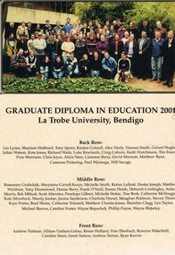
Document - LA TROBE UNIVERSITY BENDIGO COLLECTION; GRADUATE DIPLOMA IN EDUCATION 2000 LATROBE UNIVERSITY, BENDI
A laminated copy of the Graduate Diploma in Education 2000 La Trobe University, Bendigo. (The year 2001 has been changed to 2000). It displays a photo and the names of the recipients. They are - Les Lyons, Shannon Hubbard, Tony Speirs, Kirsten Colwell, Alex Vardy, Vanessa Smith, Gerard Hughes, Julian Watson, Kate Jones, Richard Wade, Luke Rowlands, Craig Coburn, Keith Hutchinson, Tom Esnouf, Prue Morrison, Chris Joyce, Alicia Sims, Cameron Barry, David Marriott, Matthew Ryan, Cameron Pickering, Fred Wierenga, Wilf Savage, Rosemary, Grubelnik, Maryanne Carroll-Keays, Michelle Smith, Rohan Lelliott, Deslee Joseph, Matthew Wickham, Tony Drummond, Denise Berry, Frank O'Neill, Emma Hards, Deborah Cordingley, Anita Morris, Bek Mifsud, Scott Alterator, Penelope Gilbert, Michelle Stokie, Tine Brok, Catherine McDougall, Kate Silverback, Wendy Jordan, Janine Sanderson, Charlotte Daniel, Meaghan Feldman, Steven Thorne, Kaye Porter, Brad Shone, Catherine Trimnell, Matthew Charles-Jones, Sheridan Clegg, Lyn Taylor, Michael Reeves, Caroline Foster, Wayne Repacholi, Phillip Payne, Wayne Blakeley, Andrew Pattison, Allison Umbers-Leitao, Renee Holland, Fran Eberbach, Rowena Wakefield, Caroline Steen, Sarah Siakew, Andrew Sutton and Ryan Kervin.bendigo, education, la trobe university bendigo, la trobe university bendigo collection, collection, bendigo, education, teaching, teachers, students, tertiary education, graduate diploma, la trobe university bendigo -
 Bendigo Historical Society Inc.
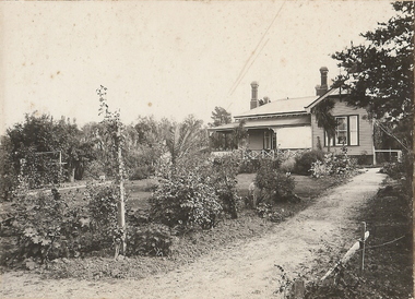
Photograph - T C WATTS & SON COLLECTION: 'TIRRANNIE' GOLDEN SQUARE, 1929
Thomas Crouch Watts was born on March 7th. 1865, to Joseph and Susan Watts. Before the real estate business commenced, Thomas and his brother were in partnership as booksellers and stationers in a shop at View Point. Thomas lived in a fine house in Rowan Street, which was called 'Ottawa' Thomas started his real estate business in the early 1900s in a shop in View Street. His daughter Edna was the book keeper and typist, Stewart Watson was the salesman and Stanley Phipps (Edith Lunn's father) was the property manager and valuer. When Thomas Watts died in 1914, his daughter took over the running of the business. She married Stewart Watson in 1918. Eventually the name of the business was changed to Bishop and Earl. From a letter from Edith Lunn re T.C. Watts & Son. 'The firm of T.C. Watts & Son later became Bishop and Earl. When the firm of Bishop and Earl ceased to operate after the death of Edith Lunn's father, S.P. Bishop, Miss. June Parry, Secretary of the BHS was a member of staff. June rescued all the photos of properties listed for sale from the office and placed them into the custody of the BHS.'Black and white original photographs (3) mounted on rectangular brown board. House, weatherboard, corrugated iron roof, return verandah with crossed wooden balustrade.4 chimneys. Garden with small palm tree. On back : Mr. Taylor.. 'Tirrannie', Golden Square, £ 2100 , inc. billiard table, linos, overmantle, 4 1/2 acres. 'April 1929' written faintly on back of one image. On front a sticker attached ' April 1929 ' Tiirannie' Golden Square, £2500 - 4 1/2 acres' ( possibly a later attachment for display purposes ) Used by Estate Agent T.C. Watts & Son to show potential purchases in 1929. Previous Reg. No. 'MP 5'. See also Reg. No. 2000.006.01Frank A. Jeffree, Bendigoplace, building, residential -
 Bendigo Historical Society Inc.
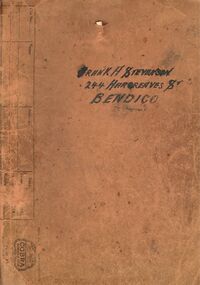
Document - BILL ASHMAN COLLECTION: CORRESPONDENCE
Dull orange folder containing copies of letters, brochures, information sheets and some newspaper cuttings. Name on the front is Frank A. Stevenson 244 Hargreaves St Bendigo. Letters date from 1937 to 1942. Newspaper titles include: Prevention of Rust- Principle of the Scalebuoy, Scalebuoys in Cars, Tragic Death of Captain Hartley Abbott and the Obituary of Captain R.H.S.Abbott.sciences, instruments - general, scalebuoy, bill ashman collection - correspondence, frank a stevenson, mr bacon, amalgamated freezing co bendigo, g whalley, gunbower co-operative butter factory & trading coy ltd, mr wallace, j charlesworth, d v evershed, bendigo electronic co, walshes crown hotel, hunter bros, wybgones unit, 180 gold mining co, o'hallorans cyanide unit, crystal ice works, stevenson unit, bendigo council, central nell gwynne, nth deborugh g m co, deborugh g m c, deborugh consolidated, cohuna butter factory, geo ross, victorian producers' co-operative coy ltd, h abbott, ernest f o liddell, rothacker bros, motor spares ltd, leggo's buildings, t j jorgensen, mr robinson, stevenson bros, r h s abbott, d c house, the electrical factor in metabolism, w n abbott, the great boulder proprietary gold mines ltd, w o galletly, mr stronell, newport workshops, victorian railways, mr brownbill, mr james, the university of melbourne, j l osborne, n clarkson, sister mary gonzaga, st joseph's hospital, mater misericordiae hospital, mr herzog, sister m monica?, vacuum oil, j johns, h j grigg, w a walsh, market square, crown hotel, g e cole, transport & engineering in australia 16/12/1937, mr menderson, mr ross, sanitary age 8/2/1935, northern kiwanis clubs, harry a baxter, w h cunningham & hill ltd, link-belt co ltd, sir william crooks, royal zoological society, ginna works germany, close brothers, w h taylor, geo taylor hardware co ltd, details of hydraulic spinner unit (scalebuoy), a davidson, john g kelly inc, hannon, myers wishart, kennedy, mr critten, pennsylvania rubber coy, paul a douden & co, w e humphrey, kansas city public service co, smith, tangney hotels, wahkonsa hotel, muscatine hotel, arlington hotel, burke hotel, helen tangney-springer, f w woolworth co, w w edan, ymca, n f alcock, b j ingram, scalebuoys, bendigo electronic company of australia proprietary limited, a s bloomfield, harry ponsonby mackenzie, arthur robinson & co, the commercial banking company of sydney ltd, a t madden, victorian railways, e c eyers, city of bendigo, frank h day, lane's motors pty ltd, h c holland, union oil soap & candle co ltd, knox home, n a duthie, w h mccorkindale, maungatapere co-op dairy co ltd, the whangarei co-op dairy co ltd, w h millingford, kettering cartons limited, j g arlidge, w e humphrey, kansas city public service company, h w smith, prospectus of scale buoy distributors limited, edwin gripper banks, richard hartley smith abbott, frank shaw fitchett, hayden smith & fitchett, the commercial bank of australia limited, william john stanley horsfall, frank cooper, scott's hotel, a j phillips, stringer & phillips proprietary ltd, e g banks, edwin gripper banks, reginald william stringer, frank cooper, claude gordon robinson, s reid -
 Bendigo Historical Society Inc.
Document - BILL ASHMAN COLLECTION: CORRESPONDENCE
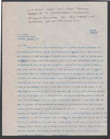
... - Correspondence Frank Stevenson Mr L Taylor Mrs Paynter Carbon copy ...Carbon copy of a typed letter to Mr. L. Taylor, dated 18/8/57. Letter recommending the Hand Shaker Unit supplemented with the Vest Pocket Unit . The Vest Pocket Unit is OK for table use. Note at the top of the page mentions a typical reply from Frank Stevenson where he recommends the hank Shaker Unit supplemented with the Vest Pocket Unit.sciences, instruments - general, scalebuoy, bill ashman collection - correspondence, frank stevenson, mr l taylor, mrs paynter -
Port Melbourne Historical & Preservation Society
Book, Terry Keenan, A Taste of Port, Apr 1999
Researched for years by the author, who has also researched the PMCC (for which he played and later was for some years President)(.01)'A Taste of Port - Personal Profiles, snapshots and statistical records drawn from the history of the Port Melbourne Football Club' by Terry KEENAN. Red and blue paperback 1999, signed by author. (.02) Letter to Martin FLANAGAN - writer for "The Age" - from Terry KEENAN regarding the Prahran Football Club. Letter is inside back cover of above book.Signed 'Terry Keenan' on title pagesport - australian rules football, societies clubs unions and other organisations, terry keenan, norm goss snr, norm goss jnr, denise goss, kevin goss, paul goss, michael goss, lilian 'lil' goss nee johnson, goss family, tommy lahiff, vic aanensen, frank johnson, george ogilvie, billy henneysee, billy fraser, jack hutchinson, john croft, george taylor, bob merrick, bill bedford, ron bedford, ted freyer, bob bonnett, alma football club, graeme anderson, ron barassi, william 'bill' barfoot, jack mcmurray, alexander harold james howlett, joe garbutt, billy mcgee, arthur knox, bob skilton jnr, bob skilton snr, port melbourne football club, pmfc, j kitchen & sons pty ltd, fred cook -
Port Melbourne Historical & Preservation Society
Photograph - Class 8, Nott Street School, Nott Street Class VIII 1941, 1941
... GIBBONS Jack BOYDEN Frank BRENNAN George TAYLOR Fred PERAZZO Alan ...Norma and Ruth ? (twins)Lasercopy of Nott Street School photograph, class 8 of 1941'Nott St School 1427 VIII 1941'education - primary schools, arthur keeping, ray gibbons, jack boyden, frank brennan, george taylor, fred perazzo, alan mccarthy, ken hudson, alan turner, fred cooper, betty wooley, betty lyons, joyce jenkinson, pearl nicol, joyce renfrey, hodges, kenny hennessy, alma rowe, betty watt, reba wright, joan jarvis, moya hannan, shirley rochford, pat andrews, june cooper, vic thompson, irene birch, nancy brown, beryl hall, norma ?, ruth ?, joyce irving, sylvia craig, dorothy richardson, ron egaroff, amy mick, len chiviers, wally myers, percy carter, jimmy lewis, fred billings, jack timms, bobby newman, ron bedford, ron stephenson, nott street state school -
 Bendigo Historical Society Inc.
Newspaper - JENNY FOLEY COLLECTION: TEAM SPIRIT
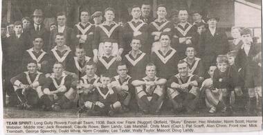
Bendigo Advertiser "The way we were" from Friday, September 17, 2004. Team spirit: Long Gully Rovers Football Team, 1938. Back row: Frank (Nugget) Oldfield, "Bluey" Enever, Hec Webster, Norm Scott, Horrie Webster. Middle row: Jack Rosewall, Claude Rowe, Bern Landy, Les Marshall, Chris Mani (captain), Pat Scarff, Alan Chinn. Front: Mick Trembath, George Speechly, David White, Norm Crossley, Les Taylor. Mascot: Doug Landy.newspaper, bendigo advertiser, the way we were -
 Bendigo Historical Society Inc.
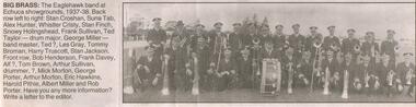
Newspaper - JENNY FOLEY COLLECTION: BIG BRASS
... Hunter, Whistler Christy, Stan Finch, Snowy Holingshead, Frank... Finch, Snowy Holingshead, Frank Sullivan, Ted Taylor, drum major ...Bendigo Advertiser "The way we were" from Saturday, July 17, 2004. Big brass: the Eaglehawk bandat Echuca showgrounds, 1937-38. Back row left to right: Stan Croshan, Suna Tab, Alex Hunter, Whistler Christy, Stan Finch, Snowy Holingshead, Frank Sullivan, Ted Taylor, drum major George Miller, band master Ted ?, Les Gray, Tommy Broman, Harry Truscott, Stan Jackson. Front row: Bob Henderson, Frank Davey, Alf ?, Tom Brown, Arthur Sullivan, drummer, Unknown, Mick Morton, George Porter, Arthur Morton, Eric Hawkins, Harold Pithie, Albert Miller and Rob Porter.newspaper, bendigo advertiser, the way we were -
 Bendigo Historical Society Inc.
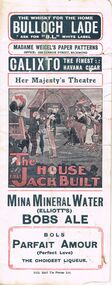
Document - THE HOUSE THAT JACK BUILT, 1915
Document: Theatre programme. 'The House That Jack Built.' Commencing at Her Majesty's Theatre Saturday Dec. 23rd. 1915. J.C. Williamson Ltd. Written by George Slater and Frank Dix. Additional scenes by Harry Taylor. Small notice 'Danger' included inside. Printer Syd. Day.George Slater + Frank Dixentertainment, theatre -
 Royal Australian and New Zealand College of Obstetricians & Gynaecologists (RANZCOG)
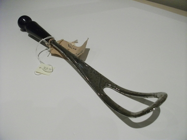
Vectis
Most likely collected and donated by Dr Frank ForsterVectis, with mahogany turned handle, "No. 4", according to label, non-retractable, no manufacturers stamp, but T.R. Taylor (Surgica PtyLtd) inscribed on old label, attached.obstetric delivery, vectis -
 Bendigo Historical Society Inc.
Document - THE MEUDELL MYSTERY
George Meudell was born in Bendigo in 1860, the son of a bank manager. He became a public accountant. He worked for B J Fink. He took up a seat on the Stock Exchange. He later wrote a book, 'The Pleasant Career of a Spendthrift'. The book caused a stir and was withdrawn from sale. There was a later edition where a lot of names were withdrawn from the book.document, names of bendigo pioneers, the meudell mystery, the land boomers, michael cannon, maurice brodzky, george meudell, table talk, bendigo high school, money miller's bank of victoria, grant meudell, hnry miller, isaac pitman, john alsop, melbourne savings bank, andrew lyell, mercantile finance co ltd, b j fink, g w taylor, thomas bent, w l baillieu, stock exchange melbourne, william knox, broken hill proprietary, f m dickenson, historical society of victoria, the pleasant career of a spendthrift, george routledge & sons ltd, routledge & kegan paul ltd, frank campbell, robertson & mullens ltd, j m gillespie, sir matthew davies's mercantile bank, unofficial history of victoria, booksellers' association, the pleasant career, theodore fink, the herald, wilke & co pty ltd, the pleasant career of a spendthrift and his later reflections, lionel robinson, william clark, s m bruce, premier building society, j kitchen & sons ltd -
Tatura Irrigation & Wartime Camps Museum
Certificate of Title, Subdivisions, 1879 and 1930
Title Deeds for property in Tatura2 certificates of title showing subdivisions made over several years. Vol. 5655:Folio 1130935 dated 16/5/1930 and Vol.1182: Folio 236330 dated 23/12/1869. Lease between Thomas Hogan and W F Bazeley dated 7th July 1911 for land in Hogan Street known as Slaughter Yard Paddock .Also lease dated 1911. In buff coloured legal envelope with number "2678" and "Hogan - Thomas" written in red on outside.tatura, relationship folders, certificate of title, lease, thomas hogan, john hogan, john james hanlon, edward glover, arthur burke, james brady, andrew collie, jean hunter, sydney embling, john maher, arthur goyen, patrick o'toole, philipe dove, george wildon, edwin harden, cuthbert corke, lee chung, hugh barnes, george manning, francis williams, john fawkner, michael walshe, alexander ferguson, rose gullett, john gibb, william taylor, richard casey, anthony grover, arthur grover, charles brady, elizabeth davey, frank williams, honora culkin, alexander park, stephen reville, richard carr, charles grover, henry mccarthy, james bruce, edward hanley, chew yen, ah poy, loo way, ah dick, charles mitchell, lionel martin, douglas forsyth, catherine wilson, mabel heath, patrick mcnamara, micheal cussen, james wilson, bazeley, documents, legal -
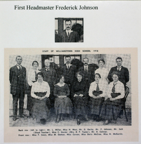 Williamstown High School
1915 - First Headmaster Frederick Johnson
Copy of a black and white photograph published in High Tide, laminated. Accompanied by 2 captions.Caption 1 reads: Mr Johnson. First Headmaster at Williamstown High. 1915-1927. Caption 2 reads: The first Departmental Headmaster. F.W. Johnson had suggested a school motto of 'Don't drift' because so many pupils tended to drift away from their early teaching. However, Frank Tate, Director of Education, recommended the more positive 'Hold fast'. This was the time of the First World War. The Germans had invaded Belgium...In designing the school badge the colours of the Belgium flag, red, yellow and black were chosen. (From school records.) On photograph: Staff of Williamstown High School, 1918. Back row (left to right): Mr L. Millar, Miss H. West, Mr D. Gerity, Mr F. Johnson, Mr Jack (Sloyd teacher), Miss C. Hunter,(mrs R.F. Taylor), Mr R. Colman. Front row: Miss F. Swan, Miss M. Deehan, Miss Carson, Miss Doris McCrae, Miss H. McGarvinwilliamstown high school, 1915, school production, mr f. w. johnson -
 University of Melbourne, Burnley Campus Archives
Photograph - Black and white print, Information Branch Victorian Department of Agriculture, Burnley Horticultural College - Staff 1974, 1974
Black and white photographs. 6 copies, 3 enlargements. Official Staff photograph. Group seated and standing in the Burnley Gardens.On reverse, "Photograph by Information Branch Victorian Department of Agriculture Ref. No. 1974 (99-1) to (99-3)." On reverse of enlargement, "Burnley Horticultural College - Staff 1974. Back l-r: Clarry Anderson, George Jackson, Eric Gay, Edward Marriott, John Kane, Fairly Siddle, David Walker, Sandra Burridge (Burrage), Rick Taylor, Rosemary Hall, Jim Edwards, Rob Hardy (Hardie), Dennis Erwin, Eddy Moore, Frank Casly (Casley). Front L-r: Geoff Olive, Ian McCure, George Grumont, Bill Nicholls, Laurie Metzling (Metzeling), Barry Dimelow, (V.P.), Eric Littlejohn (Principal), Jack Farrance, Ian Lee, Minnet(te) Russel (Russell-Young), Ken James, Paul Norquay."burnley horticultural college, staff, 1974, clarry anderson, george jackson, eric gay, edward marriott, john kane, fairly siddle, david walker, sandra burrage, rick taylor, rosemary hall, jim edwards, dennis erwin, eddy moore, geoff olive, ian mccure, george grumont, bill nicholls, barry dimelow, eric littlejohn, principal, jack farrance, ian lee, minnette russell-young, ken james, paul norquay, frank casley, laurie metzeling, rob hardy -
 University of Melbourne, Burnley Campus Archives
Photograph - Black and white print, Information Branch Victorian Department of Agriculture, Burnley Horticultural College Staff 1975, 1975
Black and white photographs. 8 copies, 7 enlarged. Staff group standing and seated in the Burnley Gardens. On reverse, "Photograph by Information Branch Victorian Department Of Agriculture Ref No. 1975 (247-1). L-R Back: Rob Hardy (Hardie), Frank Cazley (Casley), George Jackson, Danny ?, Anne ?, Sandra Burridge (Burrage), Paul Harper, Clarry Anderson, Fairlie Siddle, Jill ?, Paul Norquay, Jim Taylor, Dennis Urwin. Front: John Kane, Ken James, Ian Nisbitt (Nisbet), Ian McCure, Bruce Angus, Barry Dimelow, Eric Littlejohn, Laurie Metzling (Metzeling), Edward Marriot(t), Minette Russell (Russell-Young), George Grumont, Geoff Olive. Absent: Bill Nichols (Nicholls), Freida Wannemacher, Mandy Dick, Barry Hatfield, Kieth(Kieth) Emonsen (Emonson)."rob hardie, frank casley, george jackson, sandra burrage, paul harper, clarry anderson, fairlie siddle, paul norquay, jim taylor, dennis urwin, john kane, ken james, ian nisbet, ian mccure, bruce angus, barry dimelow, eric littlejohn, laurie metzeling, edward marriott, minette russell-young, george grumont, geoff olive, bill nicholls, freida wannemacher, mandy dick, barry hatfield, keith emonson, staff, 1975 -
 Old Castlemaine Schoolboys Association Inc.
Honour Board, Past Presidents
1912 – J. L. Thompson 1913 – G. E. Emery 1914 – S.M. Cornish 1915 – 1916 – I. Evans 1917 – J. W. B. Field 1918 – A. E. Laver 1919 – J. Anderson 1920 – T. Holmes 1921 – J. Tolstrup 1922 – A. Callaway 1923 – W. H. Seddon 1924 – J. W. McCay 1925 – H.S.W. Lawson 1926 – C. Courtney 1927 – G. Leaney 1928 – F. Tate 1929 – J.G. Yandell 1930 – C.H. Zercho 1931 – W.P. Ireland 1932 – R.A. MacGibbon 1933 – J. Daniels 1934 – A.T. Hasler 1935 – E. Hattam 1936 – J. Chenoweth 1937 – George D. McLean 1938 – J. Gilchrist 1939 – W.G. Thompson 1940 – W.H.C. Burnham 1941 – R. J. Coakley 1942 – 1943 – 1944 – Les Armstrong 1945 – Alec McGibbon 1946 – F. Tolstrup 1947 – S. Leech 1948 – J. Sheehan 1949 – J.H. Ely 1950 – E. McDougall 1951 – Murd McLean 1952 – Ern. Wait 1953 – Jim Shiel 1954 – Sam Hobson 1955 – A Mussett 1956 – Tom Veal 1957 – A. Anderson 1958 – Bert Baldwin 1959 – Jim Armstrong 1960 – Dave Crawford 1961 – Newlyn Hocking 1962 – Jack Caldwell 1963 – Ern. Franklin 1964 – Jim Webber 1965 – Jim Treasure 1966 – Jack Robertson 1967 – Lovell Langslow 1968 – Rex G. Peile 1969 – George Hogarth 1970 – J. Torrens-Witherow 1971 – Howard Ebbott 1972 – Jack Taylor 1973 – Samuel Leech 1974 – Edwin Rees 1975 – William Webb B.E.M. 1976 – Jim Ottery Q.P.M. 1977 – Frank Edwards 1978 – Geoff. Armstrong 1979 – George Archer M.B.E 1980 – Donald Ireland 1981 – Ken Martin 1982 – Bill Blume 1983 – Jack Connell 1984 – Ian Franklin 1985 – Bob Welch 1986 – Kelvin McMeekin 1987 – Edwin J Thompson 1988 – Don. L. Gamble 1989 – V.J. Pollard 1990 – B.N. Priest 1991 – R.A. Phillips 1992 – T. Williamson 1993 – George Ralph 1994 – Edgar Cue 1995 – A. L. Hassell 1996 – J.K. Cue 1997 – Richard P. Desmond 1998 – Cec. Kuhle 1999 – Trevor Cue 2000 – David A. Bailie 2001 – R.A. Morrow 2002 – Gregory J. Hughes 2003 – Ron. N. White 2004 – Terry Robinson 2005 – Peter J. Thompson 2006 – M. J. Murphy 2007 – Alan Paull 2008 – D. W. Burgess 2009 – K. F. McShanag 2010 – Steven Norris 2011 – Len Weston 2012 – Jim Chaplin 2013 – Dennis Green 2014 – Neville Cooper 2015 – Peter Cole 2016 – William Sikora -
Moorabbin Air Museum
Book - DEMOCRACY'S AIR ARSENAL, FRANK J. TAYLOR et al, 1947
... FRANK J. TAYLOR... ARSENAL FRANK J. TAYLOR LAWRENCE WRIGHT DUELL, SLOAN & PEARCE, INC ... -
 Bendigo Historical Society Inc.
Document - IAN DYETT COLLECTION: HISTORY OF THE FIRM OF W. D. MASON PTY. LTD 1894 - 1998
Five page History of the Firm of W. D. Mason Pty. Ltd. 1894 - 1998 & some personal Memoirs. History starts when Owen Walter Williams came from England to work in the glass industry. He came to Bendigo when he was given notice during the depression. Williams/Mason Family History is included and also the history of W. /d. Mason Pty. Ltd.business, auctioneers, j h curnow & son pty ltd, ian dyett collection - history of the firm of w. d. mason pty ltd 1894 - 1998, owen walter williams, ellen williams, john jughes, brooks robinson & co, henry brooks & co, shaw savill & albion company limited line, akawa (5026 tons), susan barbara lawson, walter williams, samuel thomas williams, owen mostyn williams, w daley, grandview estate, homebest, olwyn, philip harris & co limited, ann mckenzie, wavertree ellen williams, reed smart & tappin, bendigo cathedral - sacred heart, capt'n snooze, watkin williams, mr holmes, j r daley, coles supermarket, walter david mason, thompson & harvey, wavertree ellen mason, ivo james byron steel, albert g rowley, frank g o'brien, roy leonard mason, ellen mason senior - nee jamieson, alan mason, melva mason, thelma annie mason, g d garvin & g eathorne, thomas lancel hosking, alan walter mason, aif, docks operating company, ann (annie) williams, a j & a m & c x taylor -
 Bendigo Historical Society Inc.
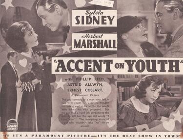
Programme - THEATRES COLLECTION: PLAZA THEATRE PROGRAMMES
Thirteen programmes for the Plaza theatre. 1) ''Accent on Youth'' with Sylvia Sidney and Herbert Marshall. 2) ''Transatlantic Merry-go-Round'' with Nancy Carroll and Gene Raymond. 3) ''We Live Again'' with Anna Sten and Fredric March. 4) ''Lilies of the Field'' with Winifred Shotter and Anthony Bushell. 5) ''Carnival in Spain'' with Marlene Dietrich, Lionel Atwill, Cesar Romero. 6) '' Kid Millions'' with Eddie Cantor and Ann Sothern. 7) ''The Mighty Barnum'' with Wallace Beery. 8) ''All the King's Horses'' with Mary Ellis and Carl Brisson. 9) ''Behold my Wife'' with Sylvia Sidney and Gene Raymond. 10) '' Without Regret'' with Elissa Landi, Paul Cavanagh, Kent Taylor and Frances Drake. 11) '' Clive of India'' with Ronald Colman and Loretta Young. 12) ''Texas Trail'' with William Boyd, Russell Hayden, Judith Allen, George Hayes. 13) ''Danny Boy'' with Ronnie Hepworth, Frank Forbes-Robertson, Dorothy Dickson, Cyril Ritchard.entertainment, theatre, plaza