Showing 104 items
matching the road to the diggings
-
 Whittlesea Historical Society Inc.
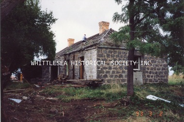
Photograph, Kath Power, Magpie Farmhouse, South Morang, March 1993
One of a series of photographs taken at Magpie Farmhouse by Kath Power when the house was being demolished, March 1993. Magpie Farmhouse, Plenty Road, South Morang. This charming old bluestone farmhouse with its moss-covered slate roof was owned for many years by one of the earliest families to settle in South Morang, the Le Pages. Two brothers, Peter and Charles Le Page, arrived in Australia from the island of Guernsey in the English Channel, in 1852 and 1854 respectively. After spending three years on the Bendigo, Castlemaine and other diggings, Peter settled in South Morang in 1855. Charles spent ten years on the Maryborough, Back Creek and Daylesford diggings before settling at South Morang in 1864. Both Peter and Charles married and raised large families at South Morang. Although the exact date is unknown, it would appear that Peter Le Page had purchased the property, known in recent times as Magpie Farm, by the 1880s. The date of construction and name of the builder of the farmhouse are also unknown, but the house would appear to have been built at least as early as the 1860s. By the early 1900s, Peter Le Page owned four farms at South Morang - Rosevilla, Hawkstowe, Riverview, and today's Magpie Farm. His son Arthur carried on dairying on the property for many years before selling out during the 1930s to the Tarry family. Subsequent owners have been the McMurray, McWilliam, Krupi and Heal families. Today the Peters family own the property although the farmhouse is currently tenanted. Dairying ceased during the late 1960s. The house was sold 1986 and demolished 1993. (Reference: Historic Buildings of the Whittlesea Shire, Robert Wuchatsch and John Waghorn, published 1985 by Whittlesea Historical Society) Photograph printmagpie farmhouse, south morang, peter le page, charles le page, le page family, bluestone house, rosevilla, hawkstowe, riverview, mcmurray family, mcwilliam family, krupi family, heal family, peters family, tarry family, dairy farm -
 Whittlesea Historical Society Inc.
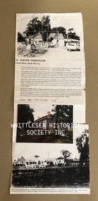
Photograph, Kath Power, Magpie Farmhouse, South Morang, March 1993
One of a series of photographs taken at Magpie Farmhouse by Kath Power when the house was being demolished, March 1993. Magpie Farmhouse, Plenty Road, South Morang. This charming old bluestone farmhouse with its moss-covered slate roof was owned for many years by one of the earliest families to settle in South Morang, the Le Pages. Two brothers, Peter and Charles Le Page, arrived in Australia from the island of Guernsey in the English Channel, in 1852 and 1854 respectively. After spending three years on the Bendigo, Castlemaine and other diggings, Peter settled in South Morang in 1855. Charles spent ten years on the Maryborough, Back Creek and Daylesford diggings before settling at South Morang in 1864. Both Peter and Charles married and raised large families at South Morang. Although the exact date is unknown, it would appear that Peter Le Page had purchased the property, known in recent times as Magpie Farm, by the 1880s. The date of construction and name of the builder of the farmhouse are also unknown, but the house would appear to have been built at least as early as the 1860s. By the early 1900s, Peter Le Page owned four farms at South Morang - Rosevilla, Hawkstowe, Riverview, and today's Magpie Farm. His son Arthur carried on dairying on the property for many years before selling out during the 1930s to the Tarry family. Subsequent owners have been the McMurray, McWilliam, Krupi and Heal families. Today the Peters family own the property although the farmhouse is currently tenanted. Dairying ceased during the late 1960s. The house was sold 1986 and demolished 1993. (Reference: Historic Buildings of the Whittlesea Shire, Robert Wuchatsch and John Waghorn, published 1985 by Whittlesea Historical Society) Photograph print mounted on sheet of paper with text and image.magpie farmhouse, south morang, peter le page, charles le page, le page family, bluestone house, rosevilla, hawkstowe, riverview, mcmurray family, mcwilliam family, krupi family, heal family, peters family, tarry family, dairy farm -
 Bendigo Historical Society Inc.
Slide - DIGGERS & MINING. THE DIGGING - THE DIGGERS, c1850s
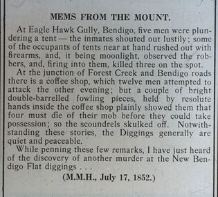
Diggers & Mining. The Digging - The Diggers. Slide; An article titled 'Mems From The Mount' At Eagle Hawk Gully, Bendigo, five men were plundering a tent - the inmates shouted out lustily; some of the occupants of tent near at hand rushed out with firearms, and it being moonlight, observed the robbers, and, firing into them, killed three on the spot. At the junction of Forest Creek and Bendigo roads there is a coffee shop, which twelve men attempted to attack the other evening; but a couple of bright double-barrelled fowling pieces, held by the resolute hands inside the coffee shop plainly showed them that possession; so the scoundrels skulled of. Not with-standing these stories, the Diggers generally are quiet and peaceable. While penning these few remarks, I have just heard of the discovery of another murder at the New Bendigo Flat Diggings. (M.M.H., July 17, 1852) Markings: -- 994.LIF:6. Used as a teaching aid.hanimounteducation, tertiary, goldfields -
 Bendigo Historical Society Inc.
Slide - DIGGERS & MINING. STORES AT THE DIGGINGS, c1855111
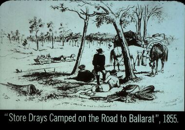
... Diggers & Mining. Stores at the diggings. ''Store Drays... at the diggings. ''Store Drays Camped on the Road to Ballarat'', 1855 ...Diggers & Mining. Stores at the diggings. ''Store Drays Camped on the Road to Ballarat'', 1855. Slide: Store dray resting on side of road with un covered wagon racing past. STG. Store Drays Camped on roadside to Ballaarat. James - Blum----Dell. Melbourne 1885. Markings: 41 994.LIF. 5. Used as a teaching aid.hanimounteducation, tertiary, goldfields -
 Bendigo Historical Society Inc.
Slide - DIGGERS & MINING. STORES AT THE DIGGINGS, c1852
Diggers & Mining. Stores at the diggings. One grievance of the diggers on the early fields was the high cost of most commodities. Prices were rising all over Victoria, but they rose even more steeply at the diggings, because, with drays and bullock-drivers at a premium, and with the roads in a bad state, the cost of cartage to the fields rose rapidly. Markings: 38 994.LIF. 5. Used as a teaching aid.hanimounteducation, tertiary, goldfields -
 Bendigo Historical Society Inc.
Slide - DIGGERS & MINING. STORES AT THE DIGGINGS, c1852
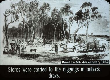
... Diggers & Mining. Stores at the diggings. Road to Mt... at the diggings. Road to Mt. Alexander, 1852. Stores were carried ...Diggers & Mining. Stores at the diggings. Road to Mt. Alexander, 1852. Stores were carried to the diggings in bullock drays. Slide shows travellers with swags and drays pulled by ox, with stores also a horse pulling a dray with supplies. Markings: 37 994.LIF. 5. Used as a teaching aid.hanimounteducation, tertiary, goldfields -
 Bendigo Historical Society Inc.
Slide - DIGGERS & MINING. STORES AT THE DIGGINGS, c1852
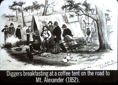
Diggers & Mining. Stores at the diggings. Diggers breakfasting at a coffee tent on the road to Mt. Alexander (1852). STG. Image from Bath Inn Diggers Breakfast. Image shows miners gathered around the Coffee Tent. The tent has a flag with emblem on it draped over the back corner of the tent. Markings: 36 994.LIF. 5. Used as a teaching aid.hanimounteducation, tertiary, goldfields -
 Bendigo Historical Society Inc.
Slide - DIGGERS & MINING. STORES AT THE DIGGINGS, c1855
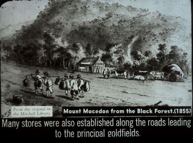
Diggers & Mining. Stores at the diggings. STG From the original in the Mitchell Library. Mount Macedon from the Black Forest. (1855) Many stores were also established along the roads leading to the principal goldfields. Slide depicts at group of Chinese passing by a store in the Black Forest o the way to the diggings. Markings: 35 994.LIF. 5. Used as a teaching aid.hanimounteducation, tertiary, goldfields -
 Bendigo Historical Society Inc.
Slide - DIGGERS & MINING: THE DIGGINGS - THE DIGGERS
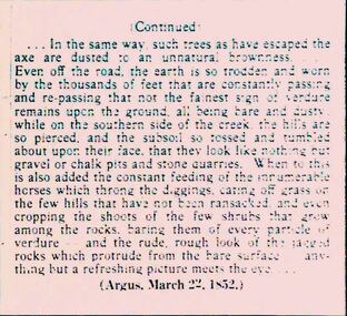
Diggers & Mining: The Digging - The Diggers. Slide: Information is continued from slide 1802.72 . Mentions lack of trees, lots of dust road. Erosion on the hills, gravel pits, stone quarries. The article is from the Argus, March 22, 1852. Markings: 26 994.LIF:6. Used as a teaching aid.hanimounteducation, tertiary, goldfields -
 Bendigo Historical Society Inc.
Slide - DIGGERS & MINING: THE DIGGINGS - THE DIGGERS
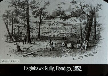
Diggers & Mining: The Digging - The Diggers. Slide depicts : Eaglehawk Gully Bendigo, 1852., 1852. Shows tents almost as far as the eye can see, miners, small girl, not many trees at the foot of a hill. On Slide: STG Eagle Hawk Gully 1852 from left of road to Bendigo. Mitchell Library. Markings: 19 994.LIF:6. Used as a teaching aid.hanimounteducation, tertiary, goldfields -
 Bendigo Historical Society Inc.
Slide - DIGGERS & MINING. STORES AT THE DIGGINGS, c1850s
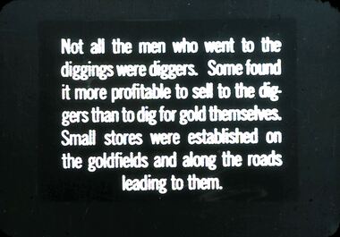
Diggers & Mining. Stores at the diggings. Not all the men who went to the diggings were diggers. Some found it more profitable to sell to the diggers than to dig for gold themselves. Small stores were established on the goldfields and along the roads leading to them. Markings: 2 994.LIF. 5. Used as a teaching aid.hanimounteducation, tertiary, goldfields -
 Maldon Vintage Machinery Museum Inc
Book, The Friends of Mount Alexander Diggings, The Iron Road to Castlemaine and Sandhurst
Newspaper observations on building the Murray River RailwayCompiled by the Friends of Mount Alexander Diggings (FOMAD) to Commemorate the 150th Anniversary of the Opening of the Melbourne to Bendigo Railway Line -
 Wodonga & District Historical Society Inc
Photograph - North-Eastern Gold Days, 1900
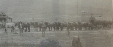
Bethanga was established as a result of the discovery of gold. Gold was first reported in the Bethanga area in 1852. Before 1876 gold mining in the Bethanga district occurred to the north of the town and was known as the 'Talgarno diggings'. Reports of alluvial gold date back to 1852. Early gold fields were worked at Ruby Creek, Gold Creek and Jarvis Creek. The opening of the Bethanga goldfields began with the discovery of a gold-bearing quartz reef on New Year’s Day 1876. The 'Gift' mine site is located southeast of Kurrajong Gap lookout to the west of Bethanga township. The Great Eastern Copper Smelting Works was opened in 1878. Due to the nature of the gold-bearing quartz reef, the gold was difficult to extract, and the discovery of copper led to a change in focus. It was not until the early 1890s that an efficient technique for extracting the gold from the ore was discovered, and once again gold became the focus, with copper as a by-product. Bethanga was removed from the official list of goldfields in 1912, however some mining activity has taken place since.This image reflects an important time in the development of Bethanga and Northeast Victoria.A large mounted and framed image of horse teams and their owners hauling a large boiler to the gold mine near Bethanga, Victoria. On label beneath image: "North-eastern "Gold Days"/ Combined teams hauling a boiler to Bethanga Mines, 1900. Teamsters - Mr. G. Pearce, W. Chapple, G, Bannon." Donated by Ron Saunders and Barbara Cadman"bethanga, gold mining northeast victoria, gold mining bethanga, bethanga history -
 Wodonga & District Historical Society Inc
Map - Tulloch & Brown's Map of the Colony of Victoria, Tulloch & Brown, 1856
The map was created by Tulloch and Brown. David Tulloch was one of the earliest engravers and lithographers in the state of Victoria. He arrived in Melbourne from Greenock, Scotland, on 3 January 1849. Following the discovery of gold Tulloch went to the Victorian goldfields in 1851, commissioned to make sketches of the diggers and the diggings for Ham’s Illustrated Australian Magazine. In November 1852 Tulloch set up in business as engraver, draughtsman, copperplate printer and lithographer. Tulloch took a map engraver, James Davie Brown, into partnership in March 1853; the several maps and specimens of commercial engraving they showed at the 1854 Melbourne Exhibition were awarded a bronze medal. That year Tulloch and Brown also received a silver medal at the Victorian Industrial Exhibition. The partnership was dissolved towards the end of 1856.This is a very early map of the Colony of Victoria including Belvoir (now know as Wodonga).A foldable map mounted on linen and with a board cover. It records the Colony of Victoria according to Surveyor's Records revised in 1857. Areas of the map are shaded to highlight different counties.At bottom right hand section of map: Tulloch & Brown's map of the Colony of Victoria : comprising part of New South Wales, the boundaries, counties, also seaport & inland townships, the gold fields with the latest discoveries, roads, tracks, &c. &c. / compiled from drawings in the Survey Office and correctly revised till 1857. Respectfully dedicated by Permission, to the Honorable Captain Andrew Clarke R.E. Surveyor General of Victoria by His Obediant Servants Tulloch & Brown, Engravers & Publishers, Melbourne". At bottom right below border : Published as the Act directs by the Proprietors, Melbourne, 1st Feb. 1856. tulloch and brown maps, rare maps victoria, victorian cartography