Showing 414 items
matching topography
-
 Lakes Entrance Historical Society
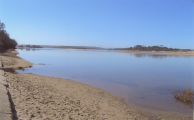
Photograph - Lakes Tyers Landing, Wendy Price, 2008
This photograph was paired with image 03733 for display Lakes Entrance 150 years 1858 to 2008 held October 2008. Lake Tyers Beach originally known as Cross's Landing.Colour photograph of Lake Tyers taken from the car park below the Water Wheel Tavern looking N.E. showing waters of lake against steep shore Lake Tyers Victoriaocean, topography -
 Lakes Entrance Historical Society
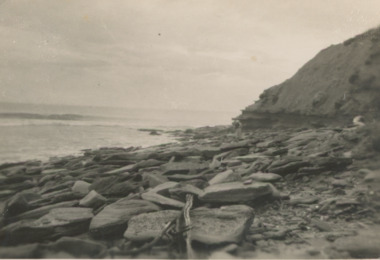
Postcard - Red Bluff, 1940c
Black and white postcard small format of east side of Red Bluff rocks and driftwood at the base, calm sea Lake Tyers Victoriatopography, ocean -
 Lakes Entrance Historical Society
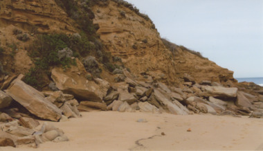
Photograph - Red Bluff 2008, Wendy Price, 1/08/2008 12:00:00 AM
This is the after photograph used in the 150 years Lakes Entrance 1858 to 2008 display held in October 2008 paired with image 03731 for displayColour photograph of west side of Red Bluff showing vegetation on the bluff rock and sand at the base situated on ninety mile beach Lake Tyers Victoria waterways, topography -
 Lakes Entrance Historical Society
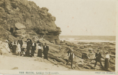
Postcard - Red Bluff 1910 c, Stanley Vogt, 1910c
Paired with image 03731.1 for display in 150 years Lakes Entrance 1858 to 2008 held in October 2008Sepia toned postcard west side of Red Bluff showing a group of eight men and five women and a child. Sand washed away exposing vast rocky beach, short vegetation on rocky bluff. Women wearing full length skirts and wide brim hats with veils, men in three piece suits dark in colour on ninety mile beach Lake Tyers VictoriaThe Bluff Lakes Entrancetopography, fashion -
 Lakes Entrance Historical Society
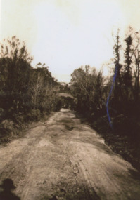
Photograph - Palmers Rd. Lakes Entrance 1927, Edie Jemmeson, 1927 c
This photograph was used in the 150 year Lakes Entrance 1858 to 2008 display as the before picture paired with colour photograph number 03727.1 as the after picture size 10 x 15 cm road now paved with many buildings showingHistoricBlack and white photograph of Palmers Road looking south towards the sand dunes and ocean, teatree along the side of the road photographers shadow in foreground, Lakes Entrance Victoriatopography, sand dunes -
 Lakes Entrance Historical Society
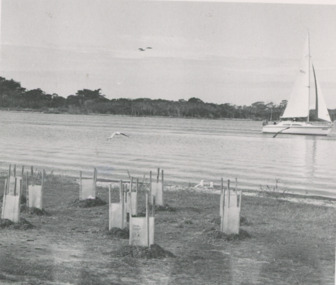
Photograph, Lakes Post Newspaper, Shaving Point Metung Victoria, 1/05/1992 12:00:00 AM
Black and white photograph of newly planted shrubs on shoreline, sailing boat on lake, timbered land opposite, taken from Shaving Point Metung Victoriawaterways, topography -
 Lakes Entrance Historical Society
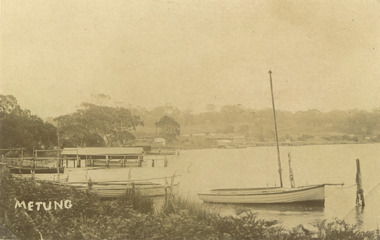
Photograph, Bancroft Bay Metung Victoria, 1900 c
Sepia toned photograph taken around Bancroft Bay shoreline showing jetties, boatshed, timbered hill beyond taken from Shaving Point Metung Victoriawaterways, topography -
 Lakes Entrance Historical Society
Book, Bedggood Lauren, The Knob Reserve, 2003
Research interpretation and management recommendations for the Knob reserve near Startford Victoria by forestec studentaboriginals, topography -
 Lakes Entrance Historical Society
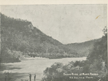
Postcard - Snowy River at Basin Ranch, Bulmer, 1930 c
Black and white postcard of Snowy River at Basin Ranch with two men in foreground pointing to high cliff across the river Gippsland VictoriaSnowy River at Basin Ranch H D Bulmer photowaterways, topography -
Lakes Entrance Historical Society
Photograph - Snowy River at Glenantipy, Rev John Flynn, 1906 c
Photographic proof on light cardBlack and white photograph of view of Snowy River from the lookout at Gelantipy Victoriatopography, waterways -
Lakes Entrance Historical Society
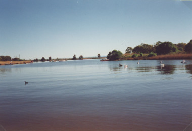
Photograph - Lake Tyers from Mill Point, 2000
Also a second photograph taken of Lake Tyers from Mill Point showing Blackfellows Arm in centre and Bills Arm on left 05107.1Colour photograph of part of Lake Tyers from Mill Point showing Toorloo Arm in centre distance Blackfellow's Arm to the left Lake Tyers Victoriawaterways, topography -
 Lakes Entrance Historical Society
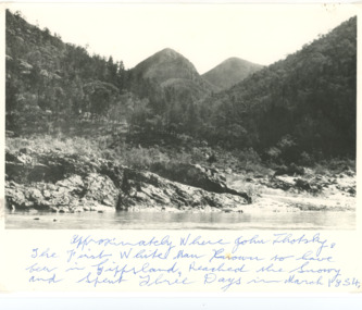
Photograph - Snowy River Buchan, 1977 c
Polish scientist explorer Dr. Lhotsky explored the Australian Alps south of Mt Kosciusko (not named at that date)as far as McKillops Bridge (unnamed then) between 1834 and 1839. His claims were largely ignored he being labelled imposter and humbug but recent research indicates his rightful place amongst Victorias early explorersBlack and white photograph of Snowy River at Suggan Buggan VictoriaApproximately where John Lhotsky the first white man known to have been in Gippsland reached the Snowy and spent three days in March 1834topography, rivers -
 Lakes Entrance Historical Society
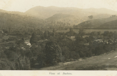
Postcard - Buchan Victoria, H D Bulmer, Little River Falls , Wulgulmerang near Buchan Victoria, 1915 c
Black and white postcard of the countryside and hills surrounding township of Buchan VictoriaView of Buchanagriculture, topography -
 Lakes Entrance Historical Society
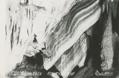
Postcard - Fairy Cave, Buchan Victoria, 1940 c
Also five postcards of caves donated by Teena Daley 04543.1, .2, .3, .4, .5 size 6.5 x 9 cmSmall black and white postcard of The Blankets, Fairy Cave, Buchan Victoria. Plus 7 other photos of various cavestopography, parks -
 Lakes Entrance Historical Society
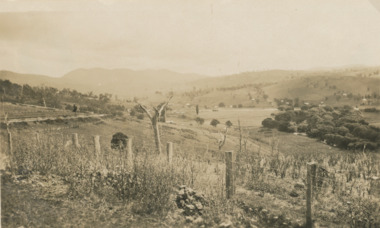
Photograph - Buchan Victoria, 1925
Sepia toned photograph of view approaching Buchan Victoriatopography, exploration -
 Lakes Entrance Historical Society
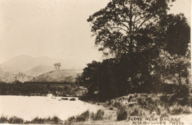
Postcard - Buchan Victoria, H D Bulmer, 1915 c
Sepia toned copy of postcard showing waterway with mountains in distance at Buchan Victoria. Also a second identical photographScene near Buchanagriculture, topography -
 Lakes Entrance Historical Society
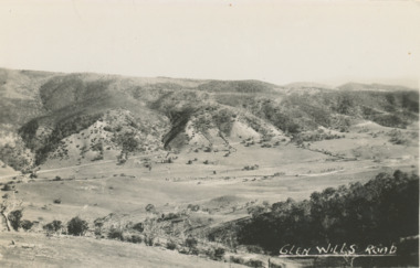
Postcard - Glen Wills Victoria, 1940 c
For over 20 years from 1893 gold mining was undertaken in the mountains around Glen Wills.Black and white postcard looking towards the Glen Wills Road situated between the valley and steep hills taken in summer Glen Wills Victoriasettlement, topography -
 Lakes Entrance Historical Society
Photograph - Mitchell River, Glenaladale Victoria, 1994 c
Colour photograph of Mitchell River from Billy Goat Bend showing steep gorge between heavily forested high banks. Glenaladale Victoria. Also two photographs of U3A Geology group on track overlooking Mitchell River and black and white photograph of Billy Goat Bend donated by Lakes Post Newspaper 6 January 2010 topography, rivers -
 Lakes Entrance Historical Society
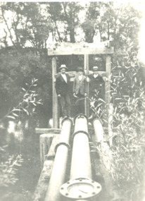
Photograph - mining in Gippsland Victoria, 1920 c
Black and white photograph showing three men standing at three water pipes beside a waterway which appears to be an abandoned pumping station perhaps associated with mining in Gippsland Victoriatopography, transport -
 Lakes Entrance Historical Society
Photograph - Mitchell River, Eagle Point Victoria
Colour photograph of Mitchell River at entrance to silt jetties near Eagle Point Victoria. Plus two other photos of Mitchell River at Eagle Point waterways, topography -
 Lakes Entrance Historical Society
Postcard, Segerberg and Bulmer, Hospital Creek East Gippsland Victoria, 1913 c
Photograph Segerberg and Bulmer in partnership 1908 - 1913Black and white postcard showing heavily timbered country surrounding a timber bridge over the flooded Hospital Creek East Gippsland Victoriaocean, topography -
Lakes Entrance Historical Society
Postcard - Kalimna Cove, H D Bulmer, 1920 c
Black and white postcard of Kalimna Cove and jetty with sailboat on water taken from,high point at Kalimna VictoriaKalimna Cove and Jettywaterways, topography -
 Bendigo Military Museum
Photograph - 4th Field Survey Squadron Adventurous Training, Wilpena pound, Flinders Ranges, SA, 1989
This is a set of 55 photographs of a 4th Field Survey Squadron adventurous training held at Wilpena pound, in the Flinders Ranges of South Australia in 1989. It is evident the training focussed on teamwork, leadership, abseiling, rock climbing, field craft and living off the land survival skills. Elements from units of the Army Reserve also participated in the training. In this photo set, one of 4th Field Survey’s sections participated in abseiling and trekked to the highest mountain in the Flinders Ranges – St. Mary’s Peak. Refer to item 6552.43P for black & white photographs taken during the adventurous training exercise.This is a set of 55 photographs of 4th Field Survey Squadron personnel undergoing adventurous training held at Wilpena pound, in the Flinders Ranges of South Australia in 1989. The colour photographs are on 35mm negative film and are part of the Army Survey Regiment’s Collection. The photographs were scanned at 96 dpi. .1) & 2)- Photo, colour, 1989. Base camp. WO1 Bill Griggs 2nd from left, remainder unidentified. .3) - Photo, colour, 1989. Old homestead inside Wilpena Pound. SPR Cheryl Deluca-Cardillo, 2nd from left, remainder unidentified. .4) - Photo, colour, 1989. Wilpena Pound topography. .5) - Photo, colour, 1989. Abseiling activities, unidentified personnel. .6) & .7) - Photo, colour, 1989. Flinders Ranges topography. .8) - Photo, colour, 1989. Abseiling activities. L to R: SSGT Max Coletti, SGT Stu Symonds. .9) - Photo, colour, 1989. Abseiling activities, unidentified personnel. .10) - Photo, colour, 1989. Flinders Ranges topography. .11) - Photo, colour, 1989. Abseiling activities. L to R: unidentified, CPL Michelle Griffith, SGT Stu Symonds. .12) - Photo, colour, 1989. Abseiling activities. L to R: unidentified, SPR Andrew Quin, SGT Laurie Justin, SGT Stu Symonds. .13) - Photo, colour, 1989. Abseiling activities. L to R: SGT Stu Symonds SGT Laurie Justin. .14) - Photo, colour, 1989. Abseiling activities. L to R: unidentified, SGT Stu Symonds. .15) - Photo, colour, 1989. Abseiling activities. SGT Laurie Justin. .16) - Photo, colour, 1989. Abseiling activities. SGT Stu Symonds. .17) & .18) - Photo, colour, 1989. Abseiling activities. SPR Cheryl Deluca-Cardillo. .19) - Photo, colour, 1989. Abseiling activities. L to R: SPR Cheryl Deluca-Cardillo, unidentified. .20) - Photo, colour, 1989. Abseiling activities. SSGT Max Coletti. .21) - Photo, colour, 1989. Abseiling activities. SPR Andrew Quin. .22) - Photo, colour, 1989. Abseiling activities. CPL Michelle Griffith. .23) - Photo, colour, 1989. Abseiling activities. CPL Michelle Griffith. .24) - Photo, colour, 1989. Flinders Ranges topography, unidentified personnel. .25) - Photo, colour, 1989. Flinders Ranges topography, unidentified SGT. .26) to .30) - Photo, colour, 1989. Flinders Ranges topography. .31) - Photo, colour, 1989. Flinders Ranges topography, unidentified personnel. .32) & .33) - Photo, colour, 1989. Flinders Ranges topography. L to R: unidentified, CPL Michelle Griffith, SGT Stu Symonds, CPL Roger Graf, SSGT Max Coletti, SGT Laurie Justin. .34) - Photo, colour, 1989. St. Mary’s Peak. L to R: unidentified, CPL Michelle Griffith, CPL Steve Nokes, SGT Stu Symonds. .35) - Photo, colour, 1989. St. Mary’s Peak. SGT Stu Symonds. .36) & .37) - Photo, colour, 1989. St. Mary’s Peak. CPL Steve Nokes. .38) - Photo, colour, 1989. Flinders Ranges topography. .39) - Photo, colour, 1989. St. Mary’s Peak. SGT Laurie Justin. .40) - Photo, colour, 1989. St. Mary’s Peak. SPR Cheryl Deluca-Cardillo. .41) - Photo, colour, 1989. St. Mary’s Peak. SPR Andrew Quin. .42) - Photo, colour, 1989. Flinders Ranges topography, SGT Stu Symonds. .43) - Photo, colour, 1989. Social activities. L to R: unidentified (x6), CPL Perry Langeberg, SGT Laurie Justin. .44) - Photo, colour, 1989. Social activities. L to R: CPL Perry Langeberg, SGT John Zuringer, SGT Laurie Justin, SGT Mick Hogan, unidentified, SGT Stu Symonds. .45) - Photo, colour, 1989. Social activities. L to R: unidentified (x6), CPL Perry Langeberg, SGT John Zuringer. .46) - Photo, colour, 1989. Social activities. L to R: CPL Jamie McRae, SGT Laurie Justin, SGT Mick Hogan, unidentified, SGT Stu Symonds, SPR Cheryl Deluca-Cardillo, WO1 Bill Griggs. .47) - Photo, colour, 1989. Social activities. L to R: SGT Laurie Justin, unidentified, CPL Steve Nokes, SGT Stu Symonds, SPR Cheryl Deluca-Cardillo, WO1 Bill Griggs, unidentified (x2). .48) - Photo, colour, 1989. Social activities. L to R: CPL Steve Nokes, WO1 Bill Griggs, SPR Cheryl Deluca-Cardillo, unidentified (x2), CPL Steve Ellis, CPL Michelle Griffith, SGT Gill Park. .49) - Photo, colour, 1989. Social activities. L to R: CPL Perry Langeberg, SGT John Zuringer, CPL Jamie McRae, SGT Laurie Justin, SGT Mick Hogan, unidentified, SGT Stu Symonds. .50) - Photo, colour, 1989. Sheep cooking in fire pit. L to R: WO2 Peter Symmans, unidentified (x5), CPL Steve Ellis. .51) - Photo, colour, 1989. Sheep cooking in fire pit. L to R: WO2 Peter Symmans, unidentified. .52) - Photo, colour, 1989. Sheep cooking in fire pit. Unidentified personnel. .53) - Photo, colour, 1989. Cooked sheep removed from fire pit. L to R: unidentified. WO2 Peter Symmans, unidentified. .54) - Photo, colour, 1989. Cooked sheep removed from fire pit. L to R: CPL Michelle Griffith, SGT Gill Park, unidentified, SSGT Max Coletti, unidentified, SPR Cheryl Deluca-Cardillo. .55) - Photo, colour, 1989. Cooked sheep removed from fire pit. L to R: unidentified, CPL Michelle Griffith, WO2 Peter Symmans..1P to .55P – There are no personnel identified. ‘1989 ADV TRAINING’ annotated on negatives sleeve.royal australian survey corps, rasvy, 4 fd svy sqn -
Lakes Entrance Historical Society
Photograph, 14/04/2013 12:00:00 AM
Colour aerial photograph of Entrance at New Works showing the sand transfer building Lakes Entrance VictoriaNew Worksaerial photograph, waterways, topography -
 Lakes Entrance Historical Society
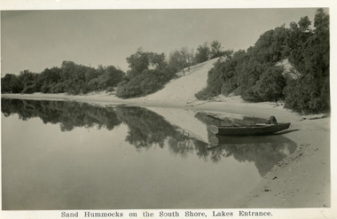
Postcard, Bulmer H D, 1930c
A second copy exists 16 x 25Black and white postcard of the south shore of Cunninghame Arm. It shows a rowing boat with dog, on the shore and the scrub covered sand hummocks. Lakes Entrance VictoriaSand Hummocks on South shore, Lakes Entrance.bridges, topography, waterways -
 Lakes Entrance Historical Society
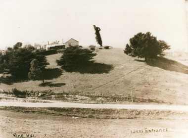
Photograph, 1950c
Also second copy which is a very clear photo.Sepia toned photograph of Pine Hill Guesthouse, showing rambling building on top of hill, landmark tree, and pine trees on hillside. Road in foreground is Princes Highway. In far distance a glimpse of Cunninghame Arm. Lakes Entrance VictoriaPine Hill Lakes Entranceguesthouses, roads and streets, topography -
 Lakes Entrance Historical Society
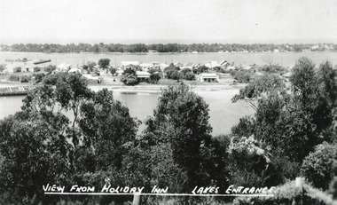
Postcard - Township, The Lakes Studio, 1945
2 Black and White postcard size copies|1 Colour tinted copy postcard size|1 Black and White enlargement 16 x 25 cmBlack and white postcard of the town, taken from Holiday Inn Guest house, situated on the Kalimna Heights escarpment. It shows light trees and scrub in the foreground, the township situated between the North Arm and Cunningham arm, the hummocks of the southern shore. The hulk of the Baang Yarnda is lying on the south shore of North Arm. Lakes Entrance VictoriaView from Holiday Inn Lakes Entrancewaterfront, topography, township -
Lakes Entrance Historical Society
Book, Mc Intyre Alan J M Lawton G, Longmans Australia Geographies Gippsland No 10, 1958
Basic information about Gippsland geography agriculture and industries written for school students.agriculture, industrial, topography -
Lakes Entrance Historical Society
Book, Trower Rosalie and Chapman Steve, Wilsons Promontory National Park
Photographic reproductions, historical detail and tourism concepts of Wilsons Promontory Victoria.parks, topography, tourism -
Lakes Entrance Historical Society
Book, Buchan Primary School, Buchan 1905 School Centenary 1877-1977, 1977
Booklet produced for the Buchan Primary School Centenary in 1977, includes lists of pupils and parents from 1914-1976 includes information on Buchan East, Buchan South, Murrindal, Gelantipy, Jackson Crossing, Butchers Ridge, W Tree, Boggy Creek, Tara Valeschools, settlers, topography