Showing 300 items
matching trees along the road
-
 Eltham District Historical Society Inc
Photograph, Spring Excursion, Hume and Hovell bus tour Stage 2, Seymour, Benalla; 26 Oct 1997, 26/10/1997
MONUMENT HUNTING THE HUME AND HOVELL WAY (Newsletter No. 117, November 1997, by Diana Bassett-Smith) Sunday October 26 1997 dawned bright and very warm. Some twenty-five members, complete with picnic baskets, met outside the Eltham Library awaiting the Cobb and Co. large coach which would be taking us on the second leg of our travels along the route of the early explorers Hume and Hovell. Stephen West was our very good driver for the day. He would be guided around the circuitous route by Russell Yeoman wh9 had made a detailed study, not only of the intended route, but of the story of these two explorers. During the trip Russell regaled us with poetry, quotations from the Journals and the History of the Shire of Seymour, "The New Crossing Place: by Martindale, 1982, (now Mitchell Shire due to the recent amalgamations). We headed towards the Hume Highway via Greensborough and Cooper Street and proceeded north to our first stop, noting on the way Monument Hill in the distance which is near Kilmore and, according to Russell, well worth the effort to visit as the view across the valley is magnificent. Past Sunday Creek Valley, Mt Piper and Mt Disappointment, all traversed and noted and named by them. We passed through Tallarook, then onto Seymour where we took photos of the monument telling us that Hume and Hovell had passed through on the 28th of October 1824. We also deviated down Hume and Hovell Road viewing deer and emu farming and the Bellbourie property now a sanctuary. Leaving Seymour behind we travelled up the Avenel Road to the Avenel monument, pyramidal in design of four reducing square blocks with a sharply pointed peak, erected in 1924 in memory of the 1824 exploration. The day was warming up and the countryside showing the dryness of the current drought. A parallel note had been made in their journal too of 1824 of the drought appearance of the country they were traversing. At Seven Creeks, Euroa we stopped for some minutes to check the monument placed 20th November 1924 to commemorate their passage on the 29th December 1824. More photos. Russell had pointed out the abrupt termination of the distant ranges which is noted in their journal. The next monument is beside the road at the entrance to Honey Suckle Creek Caravan Park, Violet Town. The squarish shaped monument some eight feet high is topped with a simple steel cross, and was to mark the date of 28th December 1824 and built for the 20th November 1924. By now it was 12.20 and nearly lunchtime as we drove along the Warranbayne Road to Roach's Road, monument hunting without success. Though there is a large, what appears to be an old timber sign which was hard to read, maybe this was the lost monument. In many of the paddocks hay had been cut and baled or was being cut, what a contrast to the rugged country they had passed through which was smoky from the fires of the natives burning off By 1.00 pm we were at Benalla and pulled up beside the park where abundant beds of roses filled the air with their scent and the smell of barbecued food twitched the nostrils whilst the cheerful sounds of other picnickers could be heard throughout the park. We left the bus and collected up our picnics, dispersed to the various tables and enjoyed the shade from the various European trees. 2.00 pm and we were on the road again driving along the Benalla, Mansfield, Yea road. The Swanpool monument states that they passed four miles south and returned three miles north. Then we stopped at the Barjarg monument which notes that they camped near this spot. It is again a pyramidal monument and this time topped with a steel arrow indicating their route of the 29th November 1824. Half an hour later we came to another monument, again with a steel arrow marker on top and the plaque dated the 2nd of 12th 1824. Erected on the 12th of 12th 1924. "They blazed the way that we might inherit the land." Another square based and needle topped monument appeared at Yarck near Yea and this plaque records the date of 3 December 1824. Near McGuigans Road Russell related that the expedition had lost a dog but it had found them next day, the dog was apparently torn by a kangaroo. A short while later Russell reminded us here of the problems they encountered in crossing the Goulburn River near Molesworth where banks were high, water deep and wide. "Good coat of grass but quite dry due to drought". At Yea we stopped for afternoon tea and raided the last of our picnics and looked at the monument to their journey of 1824, situated at a corner of the gardens near the bowling green. No photo – we were out of film. We returned home via Kinglake West and Whittlesea past the Yan Yean Reservoir, not full. 5.00 pm back at Eltham we emptied out of the bus and everyone, including Joan Cole, collected their things, Joan also had the major souvenir of the day, a large carp she had picked up from the river bank, her cat was in for a great feast. The day was made so interesting by the informed commentary which Russell provided. His background knowledge of the route and nature of the journey could only have come from many hours of reading and driving the area. Thank you to Russell and to everyone who made the day so informative and pleasurable. Diana Bassett-Smith. Record of the Society's history of activities - Spring 1997 excursionRoll of 35mm colour negative film, 6 stripsFuji 200shire of eltham historical society, activities, pretty hill, seymour, benalla, hume and hovell, monuments -
 Eltham District Historical Society Inc
Photograph, Spring Excursion, Hume and Hovell bus tour Stage 2, Seymour, Benalla; 26 Oct 1997, 26/10/1997
MONUMENT HUNTING THE HUME AND HOVELL WAY (Newsletter No. 117, November 1997, by Diana Bassett-Smith) Sunday October 26 1997 dawned bright and very warm. Some twenty-five members, complete with picnic baskets, met outside the Eltham Library awaiting the Cobb and Co. large coach which would be taking us on the second leg of our travels along the route of the early explorers Hume and Hovell. Stephen West was our very good driver for the day. He would be guided around the circuitous route by Russell Yeoman wh9 had made a detailed study, not only of the intended route, but of the story of these two explorers. During the trip Russell regaled us with poetry, quotations from the Journals and the History of the Shire of Seymour, "The New Crossing Place: by Martindale, 1982, (now Mitchell Shire due to the recent amalgamations). We headed towards the Hume Highway via Greensborough and Cooper Street and proceeded north to our first stop, noting on the way Monument Hill in the distance which is near Kilmore and, according to Russell, well worth the effort to visit as the view across the valley is magnificent. Past Sunday Creek Valley, Mt Piper and Mt Disappointment, all traversed and noted and named by them. We passed through Tallarook, then onto Seymour where we took photos of the monument telling us that Hume and Hovell had passed through on the 28th of October 1824. We also deviated down Hume and Hovell Road viewing deer and emu farming and the Bellbourie property now a sanctuary. Leaving Seymour behind we travelled up the Avenel Road to the Avenel monument, pyramidal in design of four reducing square blocks with a sharply pointed peak, erected in 1924 in memory of the 1824 exploration. The day was warming up and the countryside showing the dryness of the current drought. A parallel note had been made in their journal too of 1824 of the drought appearance of the country they were traversing. At Seven Creeks, Euroa we stopped for some minutes to check the monument placed 20th November 1924 to commemorate their passage on the 29th December 1824. More photos. Russell had pointed out the abrupt termination of the distant ranges which is noted in their journal. The next monument is beside the road at the entrance to Honey Suckle Creek Caravan Park, Violet Town. The squarish shaped monument some eight feet high is topped with a simple steel cross, and was to mark the date of 28th December 1824 and built for the 20th November 1924. By now it was 12.20 and nearly lunchtime as we drove along the Warranbayne Road to Roach's Road, monument hunting without success. Though there is a large, what appears to be an old timber sign which was hard to read, maybe this was the lost monument. In many of the paddocks hay had been cut and baled or was being cut, what a contrast to the rugged country they had passed through which was smoky from the fires of the natives burning off By 1.00 pm we were at Benalla and pulled up beside the park where abundant beds of roses filled the air with their scent and the smell of barbecued food twitched the nostrils whilst the cheerful sounds of other picnickers could be heard throughout the park. We left the bus and collected up our picnics, dispersed to the various tables and enjoyed the shade from the various European trees. 2.00 pm and we were on the road again driving along the Benalla, Mansfield, Yea road. The Swanpool monument states that they passed four miles south and returned three miles north. Then we stopped at the Barjarg monument which notes that they camped near this spot. It is again a pyramidal monument and this time topped with a steel arrow indicating their route of the 29th November 1824. Half an hour later we came to another monument, again with a steel arrow marker on top and the plaque dated the 2nd of 12th 1824. Erected on the 12th of 12th 1924. "They blazed the way that we might inherit the land." Another square based and needle topped monument appeared at Yarck near Yea and this plaque records the date of 3 December 1824. Near McGuigans Road Russell related that the expedition had lost a dog but it had found them next day, the dog was apparently torn by a kangaroo. A short while later Russell reminded us here of the problems they encountered in crossing the Goulburn River near Molesworth where banks were high, water deep and wide. "Good coat of grass but quite dry due to drought". At Yea we stopped for afternoon tea and raided the last of our picnics and looked at the monument to their journey of 1824, situated at a corner of the gardens near the bowling green. No photo – we were out of film. We returned home via Kinglake West and Whittlesea past the Yan Yean Reservoir, not full. 5.00 pm back at Eltham we emptied out of the bus and everyone, including Joan Cole, collected their things, Joan also had the major souvenir of the day, a large carp she had picked up from the river bank, her cat was in for a great feast. The day was made so interesting by the informed commentary which Russell provided. His background knowledge of the route and nature of the journey could only have come from many hours of reading and driving the area. Thank you to Russell and to everyone who made the day so informative and pleasurable. Diana Bassett-Smith. Record of the Society's history of activities - Spring 1997 excursionRoll of 35mm colour negative film, 2 stripsKodak Gold 400-5shire of eltham historical society, activities, pretty hill, seymour, benalla, hume and hovell, monuments -
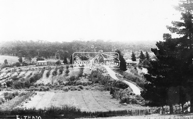 Eltham District Historical Society Inc
Negative - Photograph, Bridge Street, Eltham, c.1910
View from Maria Street (Main Road) along Bridge Street, Eltham, looking towards Montmorency. The house on the right at the corner of Susan and Bridge streets was owned for many years by the Hill family until Council bought it in the early 1960s. The house was built in the 1850s or 60s. The house on the left stood on what is now the southwest corner of Susan and Bridge Streets. The Braithwaite family was associated with this house. Orchards in the foreground either side of the Diamond Creek. The line of trees running up the hill to the left represents the Bolton street alignment. Based on hand writing of title on image compared with others, date is estimated at c.1910.This photo forms part of a collection of photographs gathered by the Shire of Eltham for their centenary project book,"Pioneers and Painters: 100 years of the Shire of Eltham" by Alan Marshall (1971). The collection of over 500 images is held in partnership between Eltham District Historical Society and Yarra Plenty Regional Library (Eltham Library) and is now formally known as the 'The Shire of Eltham Pioneers Photograph Collection.' It is significant in being the first community sourced collection representing the places and people of the Shire's first one hundred years.Digital image 4 x 5 inch B&W Negshire of eltham pioneers photograph collection, bolton steet, braithwaite, bridge, bridge street, bridge street bridge, eltham, hill family home, susan street, orchards -
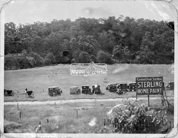 Eltham District Historical Society Inc
Negative - Photograph, Cricket match, Central Park, Eltham, c.1931
The new Central Park was opened on Monday, 21 April 1930 by Mr. W.H. Everard, M.L.A. followed by a sports carnival. The Advertiser reported on Friday, April 25, 1930 that – “Perfect weather prevailed on Monday for the sports gathering in aid of the recently-acquired park near the railway station, and from every point of view the day was a success. The Central Park contains 9½ acres, and has the Diamond Creek on one side and the railway line on the other. It cost £760, of which the council contributed £500, and the citizens, are finding the balance. Already about £80 has been spent in levelling, and a pavilion has been erected by the footballers, who will use the ground for training until it is sufficiently, improved for matches. There is ample shade along the banks of the creek, where there were numerous picnic parties. The committee has already done some planting on the railway side of the park, and where the trees grow on the higher side, overlooking the arena, the natural stand will have shade, command a view of the events, and have the trees on the banks of the creek in the distance. There were between 600 and 700 people present, many in motor cars having a little difficulty in, finding their way under the aqueduct to the ground, but the council is at present effecting improvements to the road. A merry-go round was a source of pleasure to the children, and the Northcote Soldiers and Citizens Band under Bandmaster Gore, de-lighted everyone with their varied selections of good music.” “Cr. E. J. Andrew, president of the Park Committee, said it was the first function held in the park, and although the citizens have guaranteed £420 towards it, there is still some-thing owing. Mr. W. H. Everard, M.L.A., who can always be relied upon to attend any gathering which draws the people together, said that he and Mrs. Everard had great pleasure in being present to declare the park open. He congratulated the Eltham people upon their public spirit, and the new park would be more appreciated in years to come. The other park is a splendid one, but it is far away, and one is required close to the station, so that young people can have a day's enjoyment, without having to go far from the station. The trouble in Victoria is not having enough parks. The early settlers did a lot in getting park lands, but the present generation is not doing enough. Eltham people are entitled to the highest commendation for their action, and Cr. Andrew and the council are to be thanked for what they have done. What is wanted is ingress and egress so that people can get in comfortably. When he was motoring in his wife said, "Surely you are not going down that precipice," and he replied that he would go anywhere where the people were. In the future it will be the big centre of Eltham.” Reproduced on page 96 of 'Pioneers & Painters'This photo forms part of a collection of photographs gathered by the Shire of Eltham for their centenary project book,"Pioneers and Painters: 100 years of the Shire of Eltham" by Alan Marshall (1971). The collection of over 500 images is held in partnership between Eltham District Historical Society and Yarra Plenty Regional Library (Eltham Library) and is now formally known as the 'The Shire of Eltham Pioneers Photograph Collection.' It is significant in being the first community sourced collection representing the places and people of the Shire's first one hundred years.Digital image 4 x 5 inch B&W Neg 9 x12.5 cm printsepp, shire of eltham pioneers photograph collection, eltham, eltham central park, automobile, central park, cricket match, pioneers and painters -
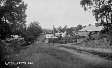 Eltham District Historical Society Inc
Negative - Photograph, Main Road, Eltham, c.1915
Sending postcards to family and friends including short messages was a common form of communication in the early 20th century from 1905 to the 1940s. Many were collected and kept in albums. This scene is viewed looking north along Main Road from near Bridge Street. The old Baker’s shop (Burgoyne’s store) on the corner of York is on the right. Also visible is the footpath dug by hand c.1906 between Yoirk Street and Bridge Street. On the left is ‘Derril’ or more commonly known as the Gahan House after it was purchased by Walter Ernest and Alice Miriam Gahan in 1924, on the western side of Main Road near the present-day site of Shillinglaw Cottage where they remained till about 1960 when Walter died. The house was demolished in 1968 during the widening of Main Road. In the distance on the bend is the Shillinglaw cottage with the Shillinglaw trees out front of the cottage. On the eastern side at the top of the hill (visible immediately to the left of the bakery) is the new St Mary’s Catholic Church on Henry Street near Main Road. The church site was relocated c.1912 from further south along Main Road (near Wingrove Cottage) in order to be more central to the congregation following the shifting of the township away from Little Eltham and closer to the railway station. It was subsequently destroyed by fire in 1961. On the back of the postcard is written: Printed Post Empire Care - correspondence - Address only - stamp Written in ink: 15 ? 1920 Many happy of the day I hope you and ? will have a very pleasant trip ? a great time when you reach England. ? & best wishes from your sincere friend E Harper?This photo forms part of a collection of photographs gathered by the Shire of Eltham for their centenary project book,"Pioneers and Painters: 100 years of the Shire of Eltham" by Alan Marshall (1971). The collection of over 500 images is held in partnership between Eltham District Historical Society and Yarra Plenty Regional Library (Eltham Library) and is now formally known as the 'The Shire of Eltham Pioneers Photograph Collection.' It is significant in being the first community sourced collection representing the places and people of the Shire's first one hundred years.Digital image 4 x 5 inch B&W Neg Sepia Postcard 9 x 14 cm 35mm positive transparencyshire of eltham pioneers photograph collection, eltham, main road, gahan house, bakery, footpath, postcard, shillinglaw cottage, shillinglaw trees, st marys catholic church, york street, michael aitken collection -
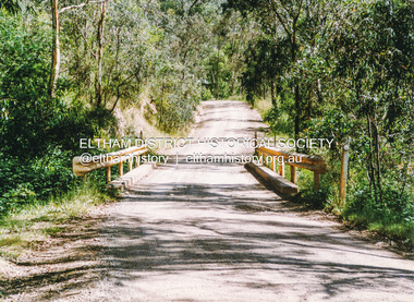 Eltham District Historical Society Inc
Photograph, Doug Orford, Bridge across Watsons Creek, One Tree Hill Road, Christmas Hills, 1991, 1991
From a collection of 35 photos taken by Doug Orford at 35 specific locations along the exact boundary of the then Shire of Eltham.Colour photographwatsons creek, christmas hills, bridges, one tree hill road -
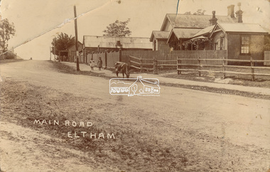 Eltham District Historical Society Inc
Photograph, J.H. Clark (poss), Main Road, Eltham, c.1910
Original photo from a scrapbook belonging to Heather Jenkins (nee Cone) who lived as a child in the Police Residence at 728 Main Road, Eltham from 1911 to the early 1920s. (Reported in Newsletter No. 98, Sept., 1994). View looking north up Policeman’s Hill across Main Road towards the Police Station, Police Residence and Courthouse, c.1910 prior to Brougham Street being made. The two rails / gap in the fence would be where Brougham Street now enters Main Road. Also visible are Knapman's Forge adjacent to Courthouse and E.J. Andrew's Store on top of the hill At the upper left can be seen the front of the Evelyn Hotel. On the opposite corner was Watsons Hotel. E.J. Andrew's store with its verandah was on the corner of Franklin Street. Behind the picket fence stands the 1860 Court House and Police residence with the weatherboard clad Police office. The enclosed fence is now the end of Brougham Street, opened to Bible Street in 1926. The Evelyn Hotel (formerly Fountain of Friendship) burnt down in the 1930s when it was being used as a boarding house since 1919. A cow is feeding on the grass verge in street. The photo is identified in white lettering typical of the style of Clark Bros., photographers of Windsor, Melbourne (1894-1914). One of the brothers, John Henry Clark, took many early photos around Little Eltham and moved to Eltham in 1916 where he lived at the bottom of the hill. Typically, he would add “J.H. Clark Photo” to his personal work, but this is not evident. There is however some ghost writing, a cheeky inscription in small white lettering in the grass verge in front of where Brougham Street is, which appears to state: “Heather or Hannah was here”. Perhaps J.H. Clark took the photo during a trip to Eltham and gifted it some years later after moving there as a gift to a young Heather Cone. The Police Station sign: E vii R ELTHAM POLICE STATION HEIDELBERG DISTRICT Edward VII ascended the throne in 1901 and died 6 May 1910. He was succeeded by George V.Heather Cone was the daughter of Constable John Thomas Cone (Badge 3935) the local police officer in residence at Eltham, 1 May 1911 to 9 July 1922. Heather McKnight Jenkins (nee Cone) was born 1911, possibly at the Eltham Police Residence and spent her childhood growing up in the Police Residence. Heather was the daughter of John Thomas Cone, Police Constable, and Charlotte Helena Cone (nee Black) who had married in 1906. Constable Cone was transferred to Eltham Police Station from Lauriston (near Kyneton) in May 1911. He retired from the force around September 1922 most likely as a result of significant health concerns experienced earlier that year from 22 April when he was hospitalised. He died 5 October 1922 at Maria Street at age 60 leaving behind a widow and two daughters; his son having pre-deceased him as a result of effects of the war. He is buried in Melbourne General Cemetery . In his probate it states that he owned a piece of land 200 links frontage to Maria Street and a depth of 241 links. It is believed that this is the land opposite the Police Station which Heather Jenkins referred to as being owned by her father and where he agisted the Police horses. Heather, her sister and mother Charlotte remained in Eltham until at least the 1924 Electoral Roll where Charlotte was listed as Home Duties however by 1925 she was listed at 229 Glenferrie Road, Malvern, occupation, Registrar of Births. In the 1934 (and 1936) Electoral Roll, Heather was a Clerk and her mother Charlotte was the Registrar of Births. in 1952 following her mother’s death she made application for Grant of Probate. Heather remains listed in the 1954 Electoral Roll at 13 Ashburton Road under her maiden name Cone however by the 1963 Electoral Roll she is listed at the same address as Heather McKnight Jenkins long with James Gardiner Jenkins. Neither appear listed in the 1958 Electoral Roll. James Gardiner Jenkins (1892-1975) first wife was Fanny Davison Carrucan (1899-1929), daughter of Denis Carrucan and Jane (nee McAleese). They married in 1925. Fanny died 11 November 1929. In the 1934 Electoral Roll he remained listed at John Street, Eltham, Railway Employee however by 1935 Electoral Roll, James Gardiner Jenkins, Railway Employee, was listed at 229 Glenferrie Road, Malvern and he remained living with Charlotte and Heather Cone when they moved to 13 Ashburton Road, Glen Iris. One of Constable Cone’s first investigations upon arriving in Eltham was the accidental fatal shooting in the head with a pea rifle by young Francis August Capewell, aged 11, of John Sutcliffe Deegan, 14, in Maria Street near the Railway. Constable Cone’s replacement was Constable William Charles Sargeant who commenced in charge of the Eltham Police Station from Thursday, 10 August 1922. Constable William Charles Sargeant, and his wife Elizabeth Agnes Sargeant were based at the Eltham Police Station until his transfer to the Police Station in Burwood Road, Hawthorn. He retired at Hawthorn Police Station in 1931, described by Hawthorn Council in 1927 as in a disgraceful condition and unfit for human habitation (Kathryn Griffin family tree – Ancestry) whereupon they moved to 28 Saunders Street, Coburg. Elizabeth died 16 July 1936 in Fitzroy. William then moved to 6 Queen Street Coburg in 1936 and then 1 Queen Street in 1942 where he died 7 August 1944. He is buried at Fawkner Cemetery.Sepia postcard photo glued on a brown paper scrapbook page (torn from scrapbook) along with 8 other black and white/sepia photos of varying sizes, 1 newspaper clipping and handwritten captions in ink.brougham street, constable w.c. sargeant, courthouse, cow, eltham, knapmans forge, little eltham, local history centre, main road, maria street, police residence, police station, policeman's hill, scrapbook, w.b. andrew corn store, j.h. clark photo, andrews store, heather jenkins (nee cone), clark bros. photo -
 Eltham District Historical Society Inc
Photograph, Spring Excursion, Hume and Hovell bus tour Stage 2, Seymour, Benalla; 26 Oct 1997, 26/10/1997
MONUMENT HUNTING THE HUME AND HOVELL WAY (Newsletter No. 117, November 1997, by Diana Bassett-Smith) Sunday October 26 1997 dawned bright and very warm. Some twenty-five members, complete with picnic baskets, met outside the Eltham Library awaiting the Cobb and Co. large coach which would be taking us on the second leg of our travels along the route of the early explorers Hume and Hovell. Stephen West was our very good driver for the day. He would be guided around the circuitous route by Russell Yeoman wh9 had made a detailed study, not only of the intended route, but of the story of these two explorers. During the trip Russell regaled us with poetry, quotations from the Journals and the History of the Shire of Seymour, "The New Crossing Place: by Martindale, 1982, (now Mitchell Shire due to the recent amalgamations). We headed towards the Hume Highway via Greensborough and Cooper Street and proceeded north to our first stop, noting on the way Monument Hill in the distance which is near Kilmore and, according to Russell, well worth the effort to visit as the view across the valley is magnificent. Past Sunday Creek Valley, Mt Piper and Mt Disappointment, all traversed and noted and named by them. We passed through Tallarook, then onto Seymour where we took photos of the monument telling us that Hume and Hovell had passed through on the 28th of October 1824. We also deviated down Hume and Hovell Road viewing deer and emu farming and the Bellbourie property now a sanctuary. Leaving Seymour behind we travelled up the Avenel Road to the Avenel monument, pyramidal in design of four reducing square blocks with a sharply pointed peak, erected in 1924 in memory of the 1824 exploration. The day was warming up and the countryside showing the dryness of the current drought. A parallel note had been made in their journal too of 1824 of the drought appearance of the country they were traversing. At Seven Creeks, Euroa we stopped for some minutes to check the monument placed 20th November 1924 to commemorate their passage on the 29th December 1824. More photos. Russell had pointed out the abrupt termination of the distant ranges which is noted in their journal. The next monument is beside the road at the entrance to Honey Suckle Creek Caravan Park, Violet Town. The squarish shaped monument some eight feet high is topped with a simple steel cross, and was to mark the date of 28th December 1824 and built for the 20th November 1924. By now it was 12.20 and nearly lunchtime as we drove along the Warranbayne Road to Roach's Road, monument hunting without success. Though there is a large, what appears to be an old timber sign which was hard to read, maybe this was the lost monument. In many of the paddocks hay had been cut and baled or was being cut, what a contrast to the rugged country they had passed through which was smoky from the fires of the natives burning off By 1.00 pm we were at Benalla and pulled up beside the park where abundant beds of roses filled the air with their scent and the smell of barbecued food twitched the nostrils whilst the cheerful sounds of other picnickers could be heard throughout the park. We left the bus and collected up our picnics, dispersed to the various tables and enjoyed the shade from the various European trees. 2.00 pm and we were on the road again driving along the Benalla, Mansfield, Yea road. The Swanpool monument states that they passed four miles south and returned three miles north. Then we stopped at the Barjarg monument which notes that they camped near this spot. It is again a pyramidal monument and this time topped with a steel arrow indicating their route of the 29th November 1824. Half an hour later we came to another monument, again with a steel arrow marker on top and the plaque dated the 2nd of 12th 1824. Erected on the 12th of 12th 1924. "They blazed the way that we might inherit the land." Another square based and needle topped monument appeared at Yarck near Yea and this plaque records the date of 3 December 1824. Near McGuigans Road Russell related that the expedition had lost a dog but it had found them next day, the dog was apparently torn by a kangaroo. A short while later Russell reminded us here of the problems they encountered in crossing the Goulburn River near Molesworth where banks were high, water deep and wide. "Good coat of grass but quite dry due to drought". At Yea we stopped for afternoon tea and raided the last of our picnics and looked at the monument to their journey of 1824, situated at a corner of the gardens near the bowling green. No photo – we were out of film. We returned home via Kinglake West and Whittlesea past the Yan Yean Reservoir, not full. 5.00 pm back at Eltham we emptied out of the bus and everyone, including Joan Cole, collected their things, Joan also had the major souvenir of the day, a large carp she had picked up from the river bank, her cat was in for a great feast. The day was made so interesting by the informed commentary which Russell provided. His background knowledge of the route and nature of the journey could only have come from many hours of reading and driving the area. Thank you to Russell and to everyone who made the day so informative and pleasurable. Diana Bassett-Smith. Record of the Society's history of activities - Spring 1997 excursionRoll of 35mm colour negative film, 6 stripsFuji 200shire of eltham historical society, activities, pretty hill, seymour, benalla, hume and hovell, monuments