Showing 2773 items matching "twentieth century"
-
 Greensborough Historical Society
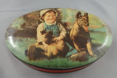
Tin, Toffee tin, 1950c
... Sweets tin, commonly used in mid-twentieth century....-twentieth century. confectionery tins Nil Oval tin with coloured lid ...Sweets tin, commonly used in mid-twentieth century.Oval tin with coloured lid with design of young boy, dog and puppyNilconfectionery tins -
 Tatura Irrigation & Wartime Camps Museum
Folio, 20th Century, Spring 1963
... Copy of article printed in "Twentieth Century", Spring... Tatura the-murray Copy of article printed in "Twentieth Century ...Copy of article printed in "Twentieth Century", Spring, 1963White A4 folder with 18 photocopied printed A5 pages held in plastic sleevesdocuments, reports -
 Eltham District Historical Society Inc
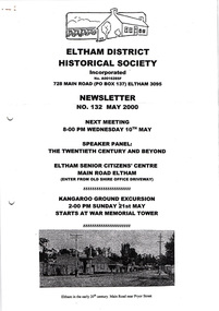
Newsletter, Newsletter, No. 132 May 2000
... • Social Activities • May Meeting – The Twentieth Century... • Social Activities • May Meeting – The Twentieth Century ...Contents: • Next meeting, Speaker Panel: The Twentieth Century and Beyond • Office Bearers 2000 • Subscriptions 2000/2001 • Social Activities • May Meeting – The Twentieth Century and Beyond • Kangaroo Ground Excursion • President’s Report • More Newsy Items The Shire of Eltham Historical Society was formed in October 1967. The first newsletter of the Society was issued May 1978 and has been published continuously ever since on a bi-monthly basis. With the cessation of the Shire of Eltham in late 1994, the Society's name was revised to Eltham District Historical Society and this name first appeared with issue No. 103, July 1995. The collection of the Society's newsletters provides a valuable resource on the history of the Society's activities, office bearers and committee members, guest speakers and subjects of historical interest pertinent to the former Shire of Eltham and the Eltham District.A4 photocopied newsletter distributed to membersnewsletter, eltham district historical society, shire of eltham historical society -
 Dutch Australian Heritage Centre Victoria
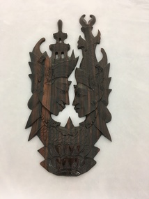
Balinese Woodcut
... the twentieth centuries, the village of Kamasan, Klungkung (East Bali... the twentieth centuries, the village of Kamasan, Klungkung (East Bali ...Balinese art is art of Hindu-Javanese origin that grew from the work of artisans of the Majapahit Kingdom, with their expansion to Bali in the late 14th century. From the sixteenth until the twentieth centuries, the village of Kamasan, Klungkung (East Bali), was the centre of classical Balinese art. During the first part of the twentieth century, new varieties of Balinese art developed. Since the late twentieth century, Ubud and its neighboring villages established a reputation as the center of Balinese art.This is likely a memento of the Dutch/Indonesia era.Carved and lacquered wooden image of male and female heads. Each is wearing a highly decorative headdress giving the impression of a special ceremony such as a wedding. The necks of the figures merge into further carving, this time of an abstract theme. -
 Greensborough Historical Society
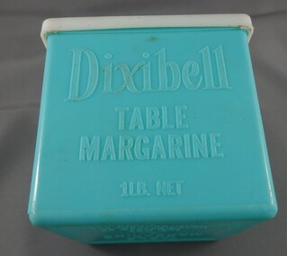
Margarine container, Provincial Traders Pty Ltd, Dixibelle table margarine, 1960c
... twentieth century... of margarine during post-war twentieth century dixibelle margarine ...Dixibelle was a common brand of margarine during post-war twentieth centuryPale green plastic box with white plastic lidDixibelle Table Margarine 1 lb. net, manufactured by Provincial Traders Pty Ltd Australia, moulded into box. Provincial Traders ceased operations on 17/10/1979 in when taken over by Henry Jones (IXL) Limited.dixibelle margarine -
 Greensborough Historical Society
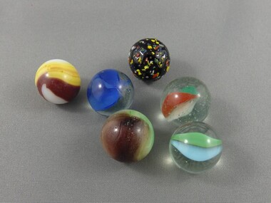
Marbles, 1960s
... the twentieth century and earlier.... in childrens' games during the twentieth century and earlier. marbles ...Marbles were commonly used in childrens' games during the twentieth century and earlier.Six Multi-coloured glass marblesmarbles -
 Buninyong & District Historical Society
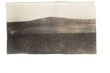
Photograph - Black and white photograph, Mount Mercer circa 1920
... in the early part of the twentieth century... in the early part of the twentieth century Representation of the small ...View of landscape and farming land at Mt Mercer in the early part of the twentieth century Representation of the small outlying rural areas near Buninyong in the early twentieth centuryLandscape around Mt Mercer circa 1920mt mercer, landscape -
 Kew Historical Society Inc
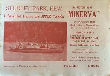
Flyer, A beautiful trip on the Upper Yarra on the motor boat 'Minerva'
... on the Yarra River in Melbourne in the first half of the twentieth... on the Yarra River in Melbourne in the first half of the twentieth ...An item of ephemera relating to tourism and recreation on the Yarra River in Melbourne in the first half of the twentieth century.An item from a large collection assembled by the Christian and Washfold families of Kew, including photographs, postcards, and ephemera. Many of the items in the Christian-Washfold Collection relate to the Yarra River and its use as as a recreational resource. Numerous items in the collection are historically important in that they are rare and often unique records of vanished locations or past recreational activities.Flyer for a ‘beautiful trip on the Upper Yarra on the motor boat ‘Minerva’. The proprietor is named as E. Burn. There is a picture of the Minerva with passengers on the front and an advertisement for Woodrow’s Hats on the reverse. christian-washfold collection, river yarra -- recreation, yarra -- boat trips, motor boat -- minerva -
 Kew Historical Society Inc
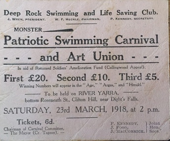
Flyer, Deep Rock Swimming and Lifesaving Club, Monster Patriotic Swimming Carnival and Art Union, 1918
... on the Yarra River in Melbourne in the first half of the twentieth... on the Yarra River in Melbourne in the first half of the twentieth ...An item of ephemera relating to tourism and recreation on the Yarra River in Melbourne in the first half of the twentieth century.An item from a large collection assembled by the Christian and Washfold families of Kew, including photographs, postcards, and ephemera. Many of the items in the Christian-Washfold Collection relate to the Yarra River and its use as as a recreational resource. Numerous items in the collection are historically important in that they are rare and often unique records of vanished locations or past recreational activities.Advertisement or ticket to a Monster Swimming Carnival to be held by the Deep Rock Swimming and Lifesaving Club in Fairfield at the bottom of Roseneath Street on Saturday 23rd March 1918 at 2 p.m.christian-washfold collection, river yarra -- recreation, yarra - swimming carnivals, deep rock pool -
 Kew Historical Society Inc
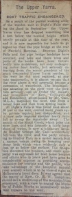
Newspaper - Article, The Upper Yarra: boat traffic endangered, 1918-20
... on the Yarra River in Melbourne in the first half of the twentieth... on the Yarra River in Melbourne in the first half of the twentieth ...An item of ephemera relating to tourism and recreation on the Yarra River in Melbourne in the first half of the twentieth century.An item from a large collection assembled by the Christian and Washfold families of Kew, including photographs, postcards, and ephemera. Many of the items in the Christian-Washfold Collection relate to the Yarra River and its use as as a recreational resource. Numerous items in the collection are historically important in that they are rare and often unique records of vanished locations or past recreational activities.Article describing the effects of the partial collapse of the weir at Dight’s Falls and its impact on water levels between Kew, Fairfield, and Heidelberg. The article is undated however as it describes Cr Harry Tompkins as Mayor of Kew it must date to the years 1918-20.christian-washfold collection, river yarra -- recreation, dight's falls -
 Kew Historical Society Inc
Photograph - Yarra River, Kew, 1925
... during the twentieth century. ... was subdivided or created into golf courses during the twentieth century ...Henry Beater Christian (1886-1962) , was a descendant of one of the earliest settler families in Kew. Employed at the Kew Asylum as a 'public servant', he was a skilled amateur photographer, photographing numerous scenes in Kew and on his travels around Victoria. The majority of his photographs date from 1916 to 1929. His finest photographs are housed in two photograph albums. Digital copy of a photograph from page 3 of the 47-page photograph album containing 261 gelatinous silver images, loaned by Diane Washfold with permission given to digitise and hold a copy in our collection. A photograph of a stretch of the Yarra River at Kew. From the 1840s, at the Crown Land Sales, lots adjacent to the river were sold and developed as dairy farms, hence the presence of cattle until the land was subdivided or created into golf courses during the twentieth century. "Yarra Rvr / Kew / 1925"henry beater christian (1886-1962), landscape photography, kew (vic.) — yarra river, christian-washfold collection, photograph albums, dairying -- kew (vic.) -
 Bendigo Historical Society Inc.
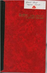
Financial record - Merle Bush Trefoil Guild: Account Book
... records plus banking and account details. Twentieth Century 100... banking and account details. Twentieth Century 100 year Calendar ...The Merle Bush Trefoil Guild was registered in Bendigo on 18/06/1981.The decision to disband the Merle Bush Trefoil Guild was made at a General Meeting on 17/02/2016. The group agreed to continue as the Merle Bush Friendship Group. The Australian Trefoil Guilds connect women who are either actively involved in Girl Guiding or have a history with Girl Guiding. The purpose of a Trefoil Guild is to keep alive the spirit of the Promise and Law, carry this spirit into the community and to give support Guiding.Account Book of the Merle Bush Trefoil Guild from 02/02/2005 to 07/03/2017. Red hard covered book with black tape on spine. White sticker on top RH corner of front cover with Merle Bush Trefoil Guild written in black pen and a Red Trefoil Guild sticker. Includes hand written Income, Receipts and Expenditure records plus banking and account details. Twentieth Century 100 year Calendar printed inside back cover.Collins 3880 Series. 3 MONEY COLUMN.. Gold lettering on Front cover.merle bush, minutes, trefoil guild, girl guides, guiding, jubilees -
 Kew Historical Society Inc
Map, MMBW, MMBW Plan No.64 Kew & Heidelberg, 1900-1910
... in the first decade of the twentieth century, at a scale 160 ft to 1... of the twentieth century, and are solid working maps, backed by linen ...The Melbourne and Metropolitan Board of Works (MMBW) was established by an act of the Victorian Parliament in 1890 to prepare for and to implement a sewerage and water reticulation system across what was then inner Melbourne, its surrounding and middle distance suburbs, including Kew. The MMBW was disbanded in 1991.The map collection of the Kew Historical Society has at its core the historic maps assembled and originally stored in the City Engineer's Department of the City of Kew. These include maps in a number of scales. The vast majority of maps were produced by the MMBW in the first two decades of the twentieth century, and are solid working maps, backed by linen for durability. These maps are historically significant to Kew, the City of Boroondara and to the history of the development of state utilities in Victoria. A number of the Kew maps have additional details added by former municipal officers, including the levels reached by various floods. As these were working documents, information was added to them long after the period of their initial production and distribution.Early map of part of the Borough of Kew, created in the first decade of the twentieth century, at a scale 160 ft to 1 inch. The map covers what was then the northern most part of Kew, bordered on its north and west by the Yarra River, in the East by Connor's Creek and by the Asylum in the south. The map shows the extent of urban development by that time, prominent institutions and the outlines of built structures in the municipality. Contour lines and historic flood levels were added in ink to the map at a later stage.MELBOURNE AND METROPOLITAN BOARD OF WORKS / PLAN NO. 64 / KEW & HEIDELBERGmelbourne & metropolitan board of works, mmbw maps, mmbw plans, borough of kew, cartography -
 Kew Historical Society Inc
Map, MMBW, MMBW Plan No.65 Kew & Heidelberg, 1900-1910
... in the first decade of the twentieth century, at a scale 160 ft to 1... of the twentieth century, and are solid working maps, backed by linen ...The Melbourne and Metropolitan Board of Works (MMBW) was established by an act of the Victorian Parliament in 1890 to prepare for and to implement a sewerage and water reticulation system across what was then inner Melbourne, its surrounding and middle distance suburbs, including Kew. The MMBW was disbanded in 1991.The map collection of the Kew Historical Society has at its core the historic maps assembled and originally stored in the City Engineer's Department of the City of Kew. These include maps in a number of scales. The vast majority of maps were produced by the MMBW in the first two decades of the twentieth century, and are solid working maps, backed by linen for durability. These maps are historically significant to Kew, the City of Boroondara and to the history of the development of state utilities in Victoria. A number of the Kew maps have additional details added by former municipal officers, including the levels reached by various floods. As these were working documents, information was added to them long after the period of their initial production and distribution.Early map of part of the Borough of Kew, created in the first decade of the twentieth century, at a scale 160 ft to 1 inch. The map covers what was then the south central part of Kew, bordered on its north by Malmsbury Street, in the west by Florence Avenue, in the south by Barkers Road, and in the east by Princess Street. The map shows the extent of urban development by that time, prominent institutions and the outlines of built structures in the municipality. Contour lines were added in ink to the map at a later stage.MELBOURNE AND METROPOLITAN BOARD OF WORKS / PLAN NO. 65 / KEW & HEIDELBERGmelbourne & metropolitan board of works, mmbw maps, mmbw plans, borough of kew, cartography -
 Kew Historical Society Inc
Map, MMBW, MMBW Plan No.66 Kew, 1900-1910
... in the first decade of the twentieth century, at a scale 160 ft to 1... of the twentieth century, and are solid working maps, backed by linen ...The Melbourne and Metropolitan Board of Works (MMBW) was established by an act of the Victorian Parliament in 1890 to prepare for and to implement a sewerage and water reticulation system across what was then inner Melbourne, its surrounding and middle distance suburbs, including Kew. The MMBW was disbanded in 1991.The map collection of the Kew Historical Society has at its core the historic maps assembled and originally stored in the City Engineer's Department of the City of Kew. These include maps in a number of scales. The vast majority of maps were produced by the MMBW in the first two decades of the twentieth century, and are solid working maps, backed by linen for durability. These maps are historically significant to Kew, the City of Boroondara and to the history of the development of state utilities in Victoria. A number of the Kew maps have additional details added by former municipal officers, including the levels reached by various floods. As these were working documents, information was added to them long after the period of their initial production and distribution.Early map of part of the Borough of Kew, created in the first decade of the twentieth century, at a scale 160 ft to 1 inch. The map covers what was then the south eastern part of Kew, bordered on its north by Adeney Avenue, in the west by Sackville Street, in the south by Barkers Road, and in the east by Burke Road. The map shows the extent of urban development by that time, prominent institutions and the outlines of built structures in the municipality. Contour lines were added in ink to the map at a later stage.MELBOURNE AND METROPOLITAN BOARD OF WORKS / PLAN NO. 66 / KEW melbourne & metropolitan board of works, mmbw maps, mmbw plans, borough of kew, cartography -
Lara RSL Sub Branch
Book, Was it Only Yesterday? 2nd Edition, Second Edition 1989
... This book Was it Only Yesterday, Australia in the Twentieth... Was it Only Yesterday, Australia in the Twentieth Century World ...This book Was it Only Yesterday, Australia in the Twentieth Century World, Second Edition, is a collation of issues relating to Australia in the 20th Century.This is an original book, Second Edition printed in 1989.Faded yellow Cardboard Cover and (226) paper pages, oblong shape.Printed by Longman Cheshire Pty Ltd 1983, First Published 1983. Written by Sheena Coupe and Mary Andrews. The name Chris Wilson written on first page. was it only yesterday, longman cheshire, sheena coupe and mary andrews -
 Kiewa Valley Historical Society
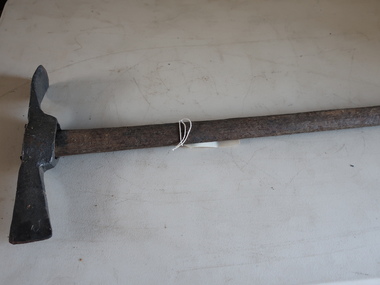
Miners Pick - long
... and early twentieth century for extracting gold from underground...' picks were commonly used in the nineteenth and early twentieth ...Miners' picks were commonly used in the nineteenth and early twentieth century for extracting gold from underground mine tunnels.Found in the Harrietville area. Similar to those used in the nearby Kiewa Valley where prospecting for gold was also an occupation.Formerly KV 071. Handmade - of steel with a wooden handle. It was used to break up rock and ore, making it easier to extract valuable minerals. The pointed end of the pickaxe was used to chip away at rock, while the flat end was used to strike the rock for breaking it apart. This one has a long handle.gold mining, miners' pick -
 Hume City Civic Collection
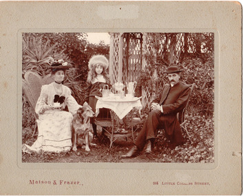
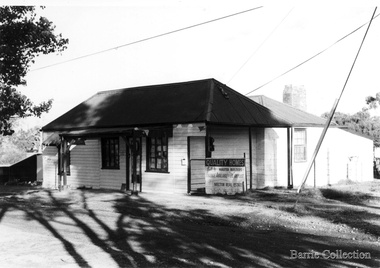
Photograph, c1907
... of the twentieth century.... of the twentieth century. gayer rev charles edward - (mrs) george evans ...The Rev. Charles Edward Gayer was the vicar at St. Mary's Church of England in Sunbury during the early decade of the twentieth century.A sepia coloured photo of the Rev and Mrs Gayer with their daughter, Crystal, in a garden setting with an afternoon tea set up. The photo is mounted on a grey cardboard mat. There are a number of stains and some foxing on it and also a number of pin holes and an area of superficial paper loss centre top of the mat.Matson and Frazer 264 Collins Streetgayer, rev charles edward, - (mrs), george evans collection -
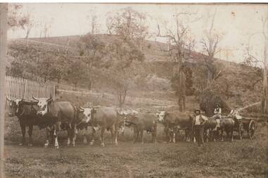 Buninyong & District Historical Society
Photograph - B/W photograph, Copy of photograph of a bullock team at Mt. Noorat
... twentieth century... twentieth century This image was taken by J.W.H. Austin, the well ...The bullock train would have been a typical means of transporting supplies across Victoria in the nineteenth and early twentieth centuryThis image was taken by J.W.H. Austin, the well-known photographer of Durham Lead from approximately 1870 who documented typical scenes of rural Victoria in the late 1800s.Copy of photograph of a bullock team at Mt. NooratBullock team at Mt. Noorat c.1899transport, j.w.h. austin, photographers, bullock train -
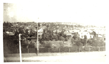 Kew Historical Society Inc
Photograph - Panoramic view of Kew East, 1925
... in the first half of the twentieth century. ... of the twentieth century. kew east urbanisation -- 1920s Inscribed verso ...East Kew was the last section of Kew to be developed following subdivision of the large estates and former farmland in the first half of the twentieth century. Original, black and white positive panorama of East Kew in 1925. By the mid 1920s, the area was already highly urbanised with core utilities such as electricity installed. Inscribed verso: "East Kew 1925" kew east, urbanisation -- 1920s -
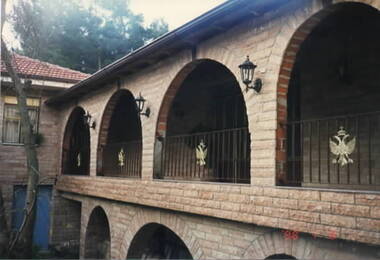 Ithacan Historical Society
Photograph, Panagias Monastery, Ithaca, Late
... in the latter part of the twentieth century. ... of Panagia Katharon in the latter part of the twentieth century ...The photograph shows the completed repairs and renovations which were carried out on the Monastery of Panagia Katharon in the latter part of the twentieth century. A coloured photograph of an arched walkway on the upper level of a building. Each arch has a metal fence with a metal coat of arms featuring a crown and winged creature across the edge. -
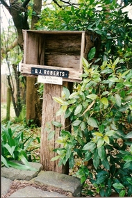 Greensborough Historical Society
Photograph - Digital image, June Roberts, Letterbox at Blackjack, 1999c
... late twentieth century..... These colour photos are from late twentieth century. june roberts ...The letterbox at "Blackjack", Hume Street Briar Hill. The Roberts family moved here in 1957. These colour photos are from late twentieth century.Digital copy of colour photographjune roberts, roberts family, blackjack, hume street briar hill -
 Dutch Australian Heritage Centre Victoria
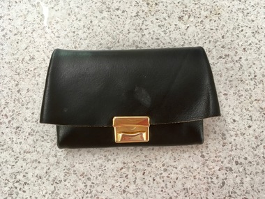
Money Purse (Portemonnee)
... -twentieth century but were laid aside in favour of wallets once... in the mid-twentieth century but were laid aside in favour of wallets ...These purses were common in The Netherlands in the mid-twentieth century but were laid aside in favour of wallets once plastic cards were introduced.A black leather purse with partitions for bank notes and coins. There is a stud to close the coin section and a brass clip to close the purse as a whole. One section contains two notes to the value of two and a half guilders; another has 19 coins to the value of 10c each; the main section holds 2 coins worth 1 guilder each, 7 worth 25cents, 3 x 5cent coins and 3 x 1 cent. -
Hume City Civic Collection
Headwear - Wooden Milliner's Model, c1920 - 1930s
... in the first half of the twentieth century.... in the first half of the twentieth century. Millinery Rob. J. Godfrey ...Rob. J. Godfrey was a company in Melbourne that manufactured many different forms of wooden milliners hat blocks in the first half of the twentieth century.A wooden milliner's block with no facial features on a square stand used by milliners to shape hat crowns. The headpiece can come apart from the base allowing another shape to fit on the stand.Stamped under the headpiece - 22.millinery, rob. j. godfrey, wooden hat blocks -
 Melton City Libraries
Photograph, Raglan Cottage, Unknown
... the late twentieth century... the late twentieth century Local Architecture Raglan Cottage ...Raglan Cottage built in the late 1850s and the Mechanics Institute are the only two buildings on High Street built before the late twentieth centuryRaglan Cottage located on High Street, Meltonlocal architecture -
 Kew Historical Society Inc
Map, MMBW, MMBW Plan No.39 Kew & Heidelberg, 1900-1910
... in the first decade of the twentieth century, at a scale 160 ft to 1... of the twentieth century, and are solid working maps, backed by linen ...The Melbourne and Metropolitan Board of Works (MMBW) was established by an act of the Victorian Parliament in 1890 to prepare for and to implement a sewerage and water reticulation system across what was then inner Melbourne, its surrounding and middle distance suburbs, including Kew. The MMBW was disbanded in 1991.The map collection of the Kew Historical Society has at its core the historic maps assembled and originally stored in the City Engineer's Department of the City of Kew. These include maps in a number of scales. The vast majority of maps were produced by the MMBW in the first two decades of the twentieth century, and are solid working maps, backed by linen for durability. These maps are historically significant to Kew, the City of Boroondara and to the history of the development of state utilities in Victoria. A number of the Kew maps have additional details added by former municipal officers, including the levels reached by various floods. As these were working documents, information was added to them long after the period of their initial production and distribution.Early map of part of the Borough of Kew, created in the first decade of the twentieth century, at a scale 160 ft to 1 inch. The map covers what was then the north western section of Kew, bordered on its north by Wills Street and the Kew Lunatic Asylum, in the west by the River Yarra [and the later added Yarra Boulevard] , by Princess Street in the East and Holroyd Street in the south. The map shows the extent of urban development by that time, prominent institutions and the outlines of built structures in the municipality. Contour lines were added in ink to the map at a later stage.MELBOURNE AND METROPOLITAN BOARD OF WORKS / PLAN NO. 39 / KEW & HEIDELBERGmelbourne & metropolitan board of works, mmbw maps, mmbw plans, borough of kew, cartography -
 Kew Historical Society Inc
Map, MMBW, MMBW Plan No.67 Kew, 1900-1910
... in the first decade of the twentieth century, at a scale 160 ft to 1... of the twentieth century, and are solid working maps, backed by linen ...The Melbourne and Metropolitan Board of Works (MMBW) was established by an act of the Victorian Parliament in 1890 to prepare for and to implement a sewerage and water reticulation system across what was then inner Melbourne, its surrounding and middle distance suburbs, including Kew. The MMBW was disbanded in 1991.The map collection of the Kew Historical Society has at its core the historic maps assembled and originally stored in the City Engineer's Department of the City of Kew. These include maps in a number of scales. The vast majority of maps were produced by the MMBW in the first two decades of the twentieth century, and are solid working maps, backed by linen for durability. These maps are historically significant to Kew, the City of Boroondara and to the history of the development of state utilities in Victoria. A number of the Kew maps have additional details added by former municipal officers, including the levels reached by various floods. As these were working documents, information was added to them long after the period of their initial production and distribution.Early map of part of the Borough of Kew, created in the first decade of the twentieth century, at a scale 160 ft to 1 inch. The map covers what was then the north central part of Kew, bordered on its north by the Outer Circle Railway Spruzen and Beresford Avenues, in the west by Princess Street, in the south by High Street, and in the east by (about) Belford Road. The map shows the extent of urban development by that time, prominent institutions and the outlines of built structures in the municipality. Contour lines were added in ink to the map at a later stage.MELBOURNE AND METROPOLITAN BOARD OF WORKS / PLAN NO. 67 / KEW melbourne & metropolitan board of works, mmbw maps, mmbw plans, borough of kew, cartography -
 Kew Historical Society Inc
Map, MMBW, MMBW Plan No.68 Kew, 1900-1910
... in the first decade of the twentieth century, at a scale 160 ft to 1... of the twentieth century, and are solid working maps, backed by linen ...The Melbourne and Metropolitan Board of Works (MMBW) was established by an act of the Victorian Parliament in 1890 to prepare for and to implement a sewerage and water reticulation system across what was then inner Melbourne, its surrounding and middle distance suburbs, including Kew. The MMBW was disbanded in 1991.The map collection of the Kew Historical Society has at its core the historic maps assembled and originally stored in the City Engineer's Department of the City of Kew. These include maps in a number of scales. The vast majority of maps were produced by the MMBW in the first two decades of the twentieth century, and are solid working maps, backed by linen for durability. These maps are historically significant to Kew, the City of Boroondara and to the history of the development of state utilities in Victoria. A number of the Kew maps have additional details added by former municipal officers, including the levels reached by various floods. As these were working documents, information was added to them long after the period of their initial production and distribution.Early map of part of the Borough of Kew, created in the first decade of the twentieth century, at a scale 160 ft to 1 inch. The map covers what was then the north central part of Kew, bordered in the north by Oak Avenue, in the west by the Yarra River and Connor's Creek, in the south by Beresford and Carnegie Avenues, and in the east by Glass's Creek and Burke Road. The map shows the extent of urban development by that time, prominent institutions and the outlines of built structures in the municipality. Contour lines and the levels of historic floods were added in ink to the map at a later stage.MELBOURNE AND METROPOLITAN BOARD OF WORKS / PLAN NO. 68 / KEW melbourne & metropolitan board of works, mmbw maps, mmbw plans, borough of kew, cartography -
 Linton and District Historical Society Inc
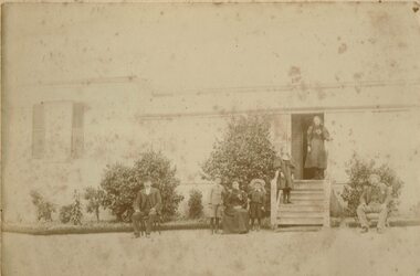
Photograph, Unidentified Family at Mt Bute Station, early 1900s
... twentieth century. Photograph shows two men, and a woman seated... but is believed to have been taken in the early twentieth century ...Mt Bute Station was a pastoral lease originally established c.1840 by Duncan Hoyle. The lease was later transferred to Charles and William Oakley (c.1853), and then to Matthew Hamilton Baird (c.1858). Sir Samuel Wilson acquired the lease in 1872 and purchased the property in 1873. Mt Bute was subdivided for soldier settlement blocks after World War I. The home block - house and 700 acres - is currently owned (2018) by the Collins family.Faded photograph mounted on cream-coloured card, which shows a family outside the residence at Mt Bute pastoral station. The photograph is undated but is believed to have been taken in the early twentieth century. Photograph shows two men, and a woman seated in chairs outside a house. A row of shrubs is across the front of the house. Two young boys are standing either side of the woman. Two young girls are standing on the steps leading to the entrance of the house. The people in the photograph have not been unidentified. A copy of the photograph was made in 2019 and is with the original.mt bute station [pastoral station] -
 Greensborough Historical Society
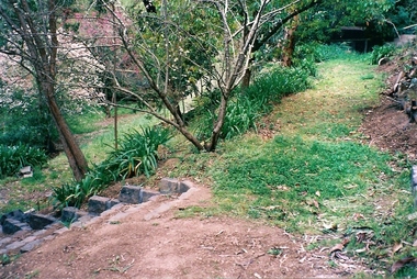
Photograph - Digital image, June Roberts, Garden steps at Blackjack, 1999c
... late twentieth century..... These colour photos are from late twentieth century. june roberts ...Garden steps at "Blackjack", Hume Street Briar Hill. The Roberts family moved here in 1957. These colour photos are from late twentieth century.Digital copy of colour photographjune roberts, roberts family, blackjack, hume street briar hill