Showing 133 items
matching waranga
-
 Bendigo Historical Society Inc.
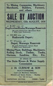
Document - IAN DYETT COLLECTION: AUCTION CATALOGUE - WARANGA RESERVOIR
Two pale green auction catalogue with black printing on the cover for a sale on the 15th August, 1934 at the Duplication Works, Waranga Reservoir, Rushworth Depot and the Depot, Waranga Reservoir, by order of The State Rivers & Water Supply Commission. For sale is Mining Plant, Buildings, Machinery, Rolling Stock, Timber, Tanks, Harness Sundries, etc. Some notes and prices written in one catalogue. Catalogues have columns on the right of the page for £, S & D to be noted.business, auctioneers, j h curnow & son pty ltd, ian dyett collection - auction catalogue - waranga reservoir, the state rivers & water supply commission, j h curnow & son, boltons print bendigo -
 Tatura Irrigation & Wartime Camps Museum
Photograph, Alan Whiting, 1924
Taken for the Victorian State Rivers and Water Supply Commission.Mounted medium sized black and white photograph. Waranga Basin earth wall concrete reinforced (middle of picture) / Tree and hut near water filled borrow pits right centre.irrigation, victorian state rivers and water supply commission, waranga basin -
Tatura Irrigation & Wartime Camps Museum
Photograph, Alan Whiting, 1924
Taken for the Victorian State Rivers and Water Supply Commission.Mounted medium sized black and white photograph. Waranga Basin outlet structure and regulator / Concrete arches and pylons / Steel handrails / Rock and earth fill walls either side of channel.irrigation, victorian state rivers and water supply commission, waranga basin -
 Tatura Irrigation & Wartime Camps Museum
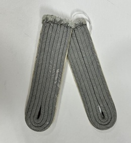
Uniform - Epaulette
Given to a very young Kurt Kazenwadel in Waranga Hospital2 German officer uniform epaulets. Grey corded hospital material formed into oblongs and forming button holes. Cream felt on the back.waranga hospital, kurt kazenwadel -
Tatura Irrigation & Wartime Camps Museum
Photograph, Alan Whiting, 1924
Taken for the Victorian State Rivers and Water Supply Commission.Mounted medium sized black and white photograph. Waranga Basin inlet structure / Concrete sides mid-upper picture / channel and basin water filled / rock filled bank left of pictureirrigation, victorian state rivers and water supply commission, waranga basin -
Tatura Irrigation & Wartime Camps Museum
Photograph, 1910
Taken by photographer for State Rivers and Water Supply Commission.Small black and white photograph. Earth embankment level being raised with clay hauled in scoops up the trestle ramp by horse-powered cable and pulleys. Workmen foreground right. Waranga reservoir. goulburn weir, victorian state rivers and supply commission -
 Tatura Irrigation & Wartime Camps Museum
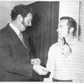
Photograph, Rudi Kuhnle
Rudi Kuhnle, Commodore of the Waranga Boat Club, with Ian Lynch. -
 Bendigo Historical Society Inc.
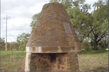
Photograph - BENDIGO HISTORICAL SOCIETY COLLECTION: BURKE AND WILLS CAIRN BARNADOWN
Colour photograph of bluestone fireplace erected at Barnadown to commemorate the camp site of the Burke and Wills expedition.The stone fireplace is a memorial to the Burke and Wills Expedition which camped near here. It was erected by the Waranga Shire Council to commemorate the centenary of the Victorian Exploring Expedition`s passage through the Barnadown district in 1860. A plaque on the structure reads: 'Burke and Wills Centenary. The party camped near this spot on 28th August 1860 on its outward journey. Erected by the Shire of Waranga 1960'.exploration, terrestrial, burke and wills -
Tatura Irrigation & Wartime Camps Museum
Photograph - copy, 1991
Colour photograph of a sweeping attractive country scene of the undulating area of the camps area in the vicinity of Waranga Basin. In the left foreground is a gentleman with his right hand to his throat and on right foreground 9 dunny buckets. -
Tatura Irrigation & Wartime Camps Museum
Folder, Yarrawonga Weir Construction 1934-1939, 1994
Photos and newspaper articles on Yarrawonga Wier official opening, 50 years after completionLarge black folder containing photos of construction of Yarrawonga Weir and coffer dam, 1936 and 2 Yarrawonga Chronicle Newspapers. Also has Waranga Basin photo and "Karlsruhe", an historic home at Lancaster. photos (8)books, history, rural, industry, irrigation -
Tatura Irrigation & Wartime Camps Museum
Painting - copy, D Albacenti, 1944
Australian Army Nursing Service Sister K. Heaphy. No 1 Hospital Waranga 1944 POW CampLaser copy of a caricature of a nurse. Watercolour painting outline in black ink. Uniform red cape, blue uniform, white veil. Holding a sall tray. Gold coloured sticker on the back.australian army nursing service, sister k. heaphy, no. 1 hospital waranga, internee paintings, dot cussens, d. albacenti -
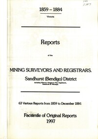 Bendigo Historical Society Inc.
Book - REPORTS OF THE MINING SURVEYORS AND REGISTRARS 1859 - 1884, 1997
Reports of the Mining Surveyors and Registrars, 1859 - 1884. Covering Sandhurst (Bendigo) district, including Kilmore, Kangaroo Flat, Eaglehawk, Heathcote, and Waranga. 63 various reports from 1859 to December 1884. Facsimile of original reports 1997.goldfields, mining reports -
Tatura Irrigation & Wartime Camps Museum
Book, Irrigation and Water Supply Development in Victoria, 1954
History of irrigaton in Victoria. Reference to Eildon Reservoir, Goulburn Weir, Waranga Reservoir, River Murray irrigation systemsBuff and blue covered book, showing farmhouse, dairy cattle on front cover, cattle, trees and channel on backirrigation, water supply, goulburn river, books, history, local -
Tatura Irrigation & Wartime Camps Museum
Pamphlet, Get Hooked on Tatura
Pamphlets to rpomote Tatura as a great place to visit with golf and bowls, tennis, horse racing and Waranga basin nearby2 pamphlets. Black and white sketches of cars in traffic jam promoting Tatura to visit and relax, on front, Tatura and relax - in red on back. Map of Tatura and list of industries and tourist sitesget hooked on tatura, promoting tatura, tatura, tourism, documents, pamphlets -
Tatura Irrigation & Wartime Camps Museum
Photograph - copy, 1988 copy
Photographed at Exhibition of Camp memorabilia, displayed at Templer Home for Aged, Bayswater, Victoria, in 1981.Colour photograph of items made by prisoners: scales made by Jone Frank; leather bag, wooden bowl, pencil case and pen, buttons, ink wells, letter opener, sketch of first excursion out of camp to Waranga Basin. Negative no 14.temple society, woodcrafts, pow, internee, camp 3 -
Tatura Irrigation & Wartime Camps Museum
Folder, Irrigation Structures, 1995
Photos of Waranga Basin outlet. Construction of new Torrumbarry Weir 1997 and newspaper report of Hume Dam and other Rural Water information.Grey plastic cover, black spine. Title label insideirrigation, documents, reports, books, history, local, rural, industry -
Tatura Irrigation & Wartime Camps Museum
Book, Rodney Water Rate Book, 1940
Rodney District Rate Book for irrigation water supply. Including Wyuna, Tongala, Kyabram, Toolamba, Murchison, Waranga. 1940-41-42-43Large book, red leather bound spine and corners. Blue cardboard cover covered with cloth front and back. White label, black writingirrigation, books, history, local, rural, industry -
Tatura Irrigation & Wartime Camps Museum
Book, Taming The Wilderness, 1985
To document the work done by the Davies family on irrigation projects of local interest such as Waranga Basin and Coliban Reservoie and family history, including "Claremont", Toolamba West.Story of one family's contribution to irrigaton in Australia - JH Davies, 2 brothers and cousin. Some members lived in Taturataming the wilderness, irrigation in australia, books, history, local -
Bendigo Historical Society Inc.
Map - PANNOOMILLOO : COUNTY OF BENDIGO, 1957
Map. Pannoomilloo, County of Bendigo, Pannoobamawm, Milloo, Diggorra, Warragamba. Elmore Cohuna Railway. Waranga Mallee Channel. By authority W.M. Houston, Government Printer, Melbourne. Drawn and reproduced at the Department of Lands and Survey, Melbourne 1957. Price 2/-. (number 83 in map cupboard 1)W.M. Houston, Government Printer, Melbourne.map, bendigo, pannoomilloo -
Tatura Irrigation & Wartime Camps Museum
Photograph, 1910
Taken by photographer for State Rivers and Water Supply Commission.Small black and white photograph. Waranga Reservoir embankment (north end) man left of picture, looking towards narrow gauge railway line along which the beaching material is transparent from a nearby hill. Windmill left of centre and small boat and house right corner.goulburn weir, victorian state rivers and supply commission -
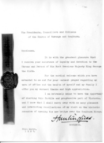 Tatura Irrigation & Wartime Camps Museum
Photograph, Lord Huntington's Letter of March 1937
Governor of Victoria, Lord Huntington, visited Tatura in March 1937. He wrote this letter, addressed to The Presidents, Councillors and Citizens of the Shires of Waranga and Goulburn, after his visit. Letter is dated 31st March 1937, is signed by Huntington, and features the official seal of the Governor's Office of Victoria.tatura, lord huntington, vic governors, documents, letters -
Tatura Irrigation & Wartime Camps Museum
Book, Water Ledger, 1928
Ledger used at State Rivers & Water Supply Commission - Rodney District, showing water discharges from Waranga and Goulburn Reservoir and Weir and channels. Also rainfall. 1928 to 1950Large book.Green cardboard cover. suede leather spine and cornersirrigation, rural, industries, irrigaiton -
Tatura Irrigation & Wartime Camps Museum
Folder, Rodney Irrigation Trust
Correspondence 1887 to and from Tatura Water Trust office. Alexander Arbuthnot photo, Starritt's sheep sale. Index and story of irrigation, Goulburn Valley Pumping Station 1885, Waranga Basin 1906Blue plastic cover, white label, gold letteringrodney irrigation trust, arbuthnot, starritt, tatura, irrigation, document, reference, rural, industry -
Tatura Irrigation & Wartime Camps Museum
Photograph, Stuart Murray Canal Sign, 1890s
Taken by photographer for State Rivers and Water Supply Commission.Medium sized black and white photograph. Sign:-"STATE RIVERS AND WATER SUPPLY COMMISSION/GOULBURN IRRIGATION SYSTEM/STUART MURRAY CANAL/CONVEYS WATER FROM GOULBURN WEIR TO WARANGA RESERVOIR/DESIGNED AND CONSTRUCTED BY VICTORIAN WATER SUPPLY DEPARTMENT - 1981./STUART MURRAY M.I.C.E CHIEF ENGINEER."goulburn weir, victorian state rivers and supply commission -
Tatura Irrigation & Wartime Camps Museum
Photograph, Basin Construction, 1919
Original Kodak postcard. Copy by D. Walker. Original photograph of a group of 14 men inspecting some new construction at Waranga Basin 1919. Donated by Laurel Bunn nee Collie 1988. Basin in background.Sepia original photograph of early basin construction. Exterioron back: Donated by Lauren Bunn, nee Collie. 1988waranga basin -
Federation University Historical Collection
Book, Historic Sites Survey: North Central Study Area, 1979, 1979
The North Central Study Area included the Shires of Avoca, Bet Bet, east Loddon, Goulburn, Untly, Kara Kara, Korong, Maldon, Marong, Metcalfe, McIvor, Newstead, Strathfieldsaye, Stawell, Talbot, Clunes, Tullaroop and Waranga. 153 page book with white plastic binding. It is an historic sites survey for the North Central Study Area commissioned by the Land Conservation Council, the Ministry for COnservation and the Australian Heritage Commission. castlemaine, mount alexander goldfield, maldon, percydale, warrenmang, moliagul, tarnagulla, stuart mill, the whipstick, whroo, rushworth, graytown ironbark forest, st arnoaud, new bendigo, landsborough, inglewood, kurting, wedderburn, wehla, kooroora, langham flat, mcintyre, rheola, diamond hill, fosterville, coliban water works, green gully, newstead, muckleford forest, costerfield, graytown, bailieston, waranga irrigaiton system, eucalyptus distillery, mia mia bridge, korokubeal township researce, concegella slate quarry, chewton, fryerstown, kingower, timor, talbot, majorca, carisbroook, clunes, st arnaud, taradale, icomos, dunolly, limestone, castlemaine slate quarry, harcourt granite, taradale railway viaduct, loddon united waterworks trust, gouldburn weir, carisbrook lock-up, history of tree planting in streets, history of public reserves, r.u. nicholls nurseryman, thomas lang, francis moss, ballarat botanical gardens, ballarat school of mines botanical gardens, lake wendouree, victoria park, ballarat, muont holled smith, ballaarat old cemetery planting, eastern oval, ballarat east botanical gardens, ballarat east town hall gardens, eureka stockade reserve, ballarat observatory plantings, yarrowee creek plantings, yarrowee bluestone channels, ballarat woollen mill, band and albion mullock heap, black hill plantings, yarrowee creek channels, canadian creek channel, specimen vale channel, poverty point reserve, union jack reserve buninyong, imperial mine, buninyong, victoria street plantings, bridge mall, sturt street gardens, ballarat avenue of honour plantings, white flat oval plantings, camp street, elms, burnt creek -
Bendigo Historical Society Inc.
Map - POMPAPIEL : COUNTY OF BENDIGO, 1-10-27
Map. Pompapiel, County of Bendigo, Calivil, Talambe, Yallook, Salisbury, Yarrayne, Janiember East, Waranga Mallee Channel, Blind Creek, Judyong Creek, Bullock Creek. Photo-Lithographed at the Dept. of Lands and Survey Melbourne by W.J. Butson 1-10-27. Price 1/-. (number 85 in map cupboard 1)W.J. Butsonmap, bendigo, pompapiel -
Bendigo Historical Society Inc.
Map - POMPAPIEL : COUNTY OF BENDIGO, 1-10-27
Map. Pompapiel, County of Bendigo, Calivil, Talambe, Yallook, Salisbury, Yarrayne, Janiember East, Waranga Mallee Channel, Judyong Creek.Pompapiel Creek, Bullock Creek, Blind Creek. Photo-Lithographed at the Department of Lands and Survey by W.J. Butson, 1-10-27. Price 1/-. (number 84 in map cupboard 1)W.J. Butson.map, bendigo, pompapiel -
Tatura Irrigation & Wartime Camps Museum
Box of Maps, early 20th century
Maps are of the following: Toolamba (2), Toolamba West (2), Undera (2), North Murchison, Coomboona (2), Mooroopna, Waranga, Kyabram East, Girgarree East, Mooroopna West (2), Tatura and Goulburn irrigation district (pre 1956).Box containing maps of individual parishes in the county of Rodney, showing early selections. Also one of early Tatura townships with owners of many house blocks. 17 maps.each one is labelled with the parish (Toolamba, Tatura, , etc.) -
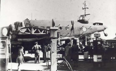 Tatura Irrigation & Wartime Camps Museum
Photograph, Liberator
This dismantled allied bomber "Liberator" crashed at Waranga Basin after flying low over Camps 3 & 4. Photograph taken at the garage, corner Hogan and Ross Streets on route to Tocumwal for repairs. Foam backed copy in file.Black and white photographallied bomber, liberator, waranga basin, aeroplane, plane, crashed plane, tatura crashed plane, waranga plane