Showing 116 items
matching water flow
-
 Bendigo Historical Society Inc.
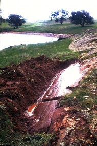
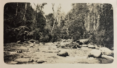
Slide - Dunn's Rock Eppalock, 2012
The low rolling hills of the Kimbolton countryside consist of ancient, hard and fractured Ordovician rock up to 65 million years old, which was originally deposited deep under the sea. Rocks mainly are sandstone, mudstone, black shale and quartz conglomerates. Marine fossils can be found in the area. Around seven million years ago a basalt flow buried the original bedrock along the along the Campaspe River. Ongoing weathering, wind and water movement over the following years has produced younger clay, sand, silt and gravel deposits throughout the area. Patches of White Hills Gravel are also found in the area. Another unique geological feature of this area is the Permian Glacial Pavement rocks north and south of Eppalock and glacial sediments (such as “Dunn’s Rock” and “Kellams Rock”). During the ice age (up to 280 million years ago) large glaciers moving over the countryside, scoured out sediments, pulverized bedrock, polished and cut grooves into bedrock in the direction of ice movement. When the ice melted boulders etc where left behind in areas of entirely different rock types, such as a 100 Tonne granite block known as ‘The Stranger’ near Derrinal. Dunn's Rock (Glaciated Pavement) Eppalock - Photos of the rock and a field group collecting date with Lake Eppalock (Knowsley) in the backgroundhistory, bendigo, dunn's rock eppalock, kimbolton forest, lake eppalock, gately collection -
 Bendigo Historical Society Inc.
Slide - DIGGERS & MINING. GETTING THE GOLD, c1850s
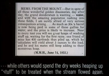
Diggers & Mining. Getting the Gold. Slide: MEMS FROM THE MOUNT - But in spite of all these wonderful golden discoveries, day after day, the grand desideratum is wanting - water, and with the amazing population rushing into these fields. I am surely afraid of very serious consequences arising . . . . As much as 30s. a barrel is now being paid I some of these gullies for water, and the price is likely to increase. Near to every tent you will see great heaps of washing stuff up, waiting for the first rains; one friend of mine has 400 cartloads this piled up, which he calculates will yield about 3 ounces to the load, and he and his mates still keep adding to their monstrous heap. (M.M.H., June 14, 1853.) . . .while others would spend the dry weeks heaping up ''stuff'' to be treated when the stream flowed again Markings: 68 994.LIF:4. Used as a teaching aid.hanimounteducation, tertiary, goldfields -
 Kew Historical Society Inc
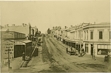
Photograph, J F C Farquhar, High Street, Kew, 1891
... gutters, which were designed to channel the significant flow... the significant flow of storm water down the hill to and beyond ...At the beginning of the 1890s, the Kew businessman and Town Councillor, Henry Kellett, commissioned J.F.C. Farquhar to photograph scenes of Kew. These scenes included panoramas as well as pastoral scenes. The resulting set of twelve photographs was assembled in an album, Kew Where We Live, from which customers could select images for purchase.The preamble to the album describes that the photographs used the ‘argentic bromide’ process, now more commonly known as the gelatine silver process. This form of dry plate photography allowed for the negatives to be kept for weeks before processing, hence its value in landscape photography. The resulting images were considered to be finely grained and everlasting. Evidence of the success of Henry Kellett’s venture can be seen today, in that some of the photographs are held in national collections.It is believed that the Kew Historical Society’s copy of the Kellett album is unique and that the photographs in the book were the first copies taken from the original plates. It is the first and most important series of images produced about Kew. The individual images have proved essential in identifying buildings and places of heritage value in the district.In 1891, High Street was the centre of commercial activity in the Borough of Kew. It was unpaved and edged with deep bluestone gutters, which were designed to channel the significant flow of storm water down the hill to and beyond the Junction. On either side of the entrance to the shopping strip are two cast iron gas lamps that provided the only public street lighting before the Post Office was reached. Most shops, including the Nicholas Brothers’ Junction Store featured cast iron verandas. Further up the hill, Dougherty’s Greyhound Hotel was by this stage a local institution. Apart from the horse-drawn tram, the main form of personal and commercial transport in this period remained the horse, horse and cart, or buggy.The panoramic view predates the widening of High Street in the 20th century, and thus includes the original alignment of buildings on the south side. These included Henry Kellett’s shop.High Street, Kewkew illustrated, kew where we live, photographic books, henry kellett, high street - kew (vic) -
 Kew Historical Society Inc
Photograph - Crossing Dights' Falls on the Yarra by foot
Dight’s Falls in Studley Park is an artificial weir built on a natural rock bar across the Yarra. The weir was built in the 1840s to provide water to the ‘Ceres’ flour-mill, one of the first in Victoria. The falls were later to become known as Dight’s Falls after the owners of the mill. Later, a pumping station was built on the Kew side of the river, which pumped water uphill to a reservoir in Walmer Street that provided water to the Melbourne Botanical Gardens and to Albert Park Lake. The area around Dight’s Falls was and is frequently used for recreational activities.Rare original print photograph of people walking across Dight's Falls when the river flow was low. View west towards Abbotsford. Photograph taken from Kew side of river above the Falls.Reverse: "M Holmes"dight's falls, river yarra -- kew - abbotsford -
 Kew Historical Society Inc
Photograph - Strickland Spur track, c.1926
... . The photographer contrasts the rapid flow of the water through the rapids.... The photographer contrasts the rapid flow of the water through the rapids ...Henry Beater Christian (1886-1962) , was a descendant of one of the earliest settler families in Kew. Employed at the Kew Asylum as a 'public servant', he was a skilled amateur photographer, photographing numerous scenes in Kew and on his travels around Victoria. The majority of his photographs date from 1916 to 1929. His finest photographs are housed in two photograph albums. Digital copy of a photograph from page 18 of the 47-page photograph album containing 261 gelatinous silver images, loaned by Diane Washfold with permission given to digitise and hold a copy in our collection. This photograph, dating from c.1926, forms part of a group of photos of the Strickland Spur track, taken on a bushwalking trip to Marysville, Victoria. John Chapman has written in 'Bushwalking Clubs - A Brief History', about the establishment in Victoria of the first bushwalking club in 1888, and the popularisation of bushwalking during the interwar period. The photograph shows either the Steavenson or Taggerty River near Marysville. The photographer contrasts the rapid flow of the water through the rapids with the stillness of the surrounding tree ferns and trees."Spur" [illegible ink inscription]henry beater christian (1886-1962), landscape photography, kew (vic.) — yarra river, christian-washfold collection, photograph albums, bushwalking -- victoria, strickland spur -
 Kew Historical Society Inc
Photograph - Acheron Way, c.1926
... the interwar period. The photographer contrasts the rapid flow... the interwar period. The photographer contrasts the rapid flow ...Henry Beater Christian (1886-1962) , was a descendant of one of the earliest settler families in Kew. Employed at the Kew Asylum as a 'public servant', he was a skilled amateur photographer, photographing numerous scenes in Kew and on his travels around Victoria. The majority of his photographs date from 1916 to 1929. His finest photographs are housed in two photograph albums. Digital copy of a photograph from page 18 of the 47-page photograph album containing 261 gelatinous silver images, loaned by Diane Washfold with permission given to digitise and hold a copy in our collection. This photograph, dating from c.1926, forms part of a group of photos taken on a bushwalking trip to Marysville, Victoria. John Chapman has written in 'Bushwalking Clubs - A Brief History', about the establishment in Victoria of the first bushwalking club in 1888, and the popularisation of bushwalking during the interwar period. The photographer contrasts the rapid flow of the water of a river through the rapids with the stillness of the surrounding tree ferns and trees."Spur" [illegible ink inscription]henry beater christian (1886-1962), landscape photography, kew (vic.) — yarra river, christian-washfold collection, photograph albums, bushwalking -- victoria, strickland spur track -
 Maldon Vintage Machinery Museum Inc
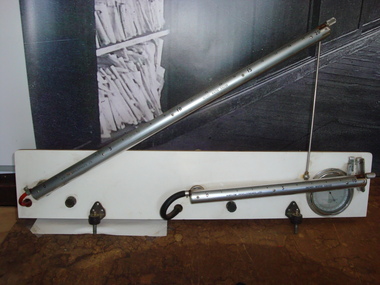
Air Flow Guage, Estimated pre 1970
Comprises two calibrated cylinders mounted on a board for measuring inches of water. Gauges measure air velocity. Cylinders are of steel with calibrations on aluminium casings. Flexible tubes are connected to reservoirs at the back of the mounting board, one black rubber the other red plastic. A reference barometer is mounted at the bottom right hand corner of the backing board. Reservoirs at the rear are of metal, coloured blue.instruments, air flow -
 Wodonga & District Historical Society Inc
Album - Hume Reservoir Australia Album - View of site on 28th November 1919
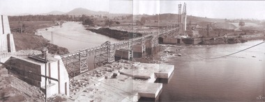
This set of photos is from a leather bound album bearing the inscription "HUME RESERVOIR AUSTRALIA" plus 'The Rt. Hon. L. C. M. S. Amery, P. C., M .P.' all inscribed in gold. It was presented to The Rt. Hon. L. C. M. S. Amery, P. C., M. P, Secretary of State for Dominion Affairs on the occasion of his visit to the Hume Reservoir on 2nd November 1927. This album is of local and national significance as it documents the planning and development of the Hume Reservoir up to 1927. It was the largest water reservoir in the British Empire. The album records the pioneering engineering work that went into its construction.DEPARTMENT OF PUBLIC WORKS, N.S.W. RIVER MURRAY WATERS SCHEME. HUME RESERVOIR. 3. View of site on 28th November 1919 when the first sod was turned by the Governor General Sir Ronald Munro Ferguson, now Lord Hovar. The view is taken from the New South Wales end of the dam looking across the Murray to Victoria. The Murray flows from left to right.hume reservoir australia, river murray waters scheme, hume weir diagrams, hume plan details -
 Wodonga & District Historical Society Inc
Album - Hume Reservoir Australia Album - General View of Works from New South Wales end, Looking Upstream, August 1927
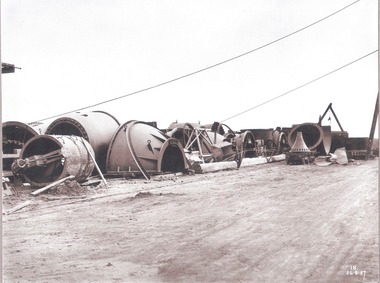
This set of photos is from a leather bound album bearing the inscription "HUME RESERVOIR AUSTRALIA" plus 'The Rt. Hon. L. C. M. S. Amery, P. C., M .P.' all inscribed in gold. It was presented to The Rt. Hon. L. C. M. S. Amery, P. C., M. P, Secretary of State for Dominion Affairs on the occasion of his visit to the Hume Reservoir on 2nd November 1927. This album is of local and national significance as it documents the planning and development of the Hume Reservoir up to 1927. It was the largest water reservoir in the British Empire. The album records the pioneering engineering work that went into its construction.DEPARTMENT OF PUBLIC WORKS, N.S.W. RIVER MURRAY WATERS SCHEME. HUME RESERVOIR. 22. General View of Works from New South Wales end, Looking Upstream. Features: At the left, part of the North Wing Wall, the highest part of which is 26 feet below its ultimate height. Below in the foreground is the portion of the dam where provision is to be made for hydro-electric generation. The tubes, three in number, 13 feet in diameter, will be laid on the level shown and an early start will be made in laying them. The level for the other four regulating outlets, 9 feet in diameter, together with a part of the spillway section of the dam, is underwater at this stage and it may be remarked that at one point, about half way across the channel where the water is now flowing, the concrete foundations are about 80 feet below the level of the water. The broken surface of the water is due to the large “plums” in the concrete. The still water in the right foreground is the stilling pool over the concrete floor of which there is now more than 20 feet of water and by means of which the discharge from the outlet pipes will be quelled. The trestlework on the upstream side of the dam carries the concrete belt conveyor. It extends from the concrete mixer house, which is out of the picture, behind the wing wall, along almost the entire length of the concrete portion of the dam. The concrete is discharged from the belt at any desired point by means of trippers, one of which may be seen over the second trestle. On the other side of the flowing water is the coffer dam. A channel 300 feet wide involving about 140,000 cubic yards of excavation and dug for the temporary diversion of the river as it is flowing now. To the right top of the view beyond the Coffer Dam is the earth embankment being thrown across the major part of the valley by the Victorian Constructing Authority. The Mitta Mitta River flows into the Murray at the far end of the reach of water on the left. August 1927.hume reservoir australia, river murray waters scheme, hume reservoir construction -
 Wodonga & District Historical Society Inc
Album - Hume Reservoir Australia Album - Needle valves, August 1927
This set of photos is from a leather bound album bearing the inscription "HUME RESERVOIR AUSTRALIA" plus 'The Rt. Hon. L. C. M. S. Amery, P. C., M .P.' all inscribed in gold. It was presented to The Rt. Hon. L. C. M. S. Amery, P. C., M. P, Secretary of State for Dominion Affairs on the occasion of his visit to the Hume Reservoir on 2nd November 1927. This album is of local and national significance as it documents the planning and development of the Hume Reservoir up to 1927. It was the largest water reservoir in the British Empire. The album records the pioneering engineering work that went into its construction.DEPARTMENT OF PUBLIC WORKS, N.S.W. RIVER MURRAY WATERS SCHEME. HUME RESERVOIR. 34. Needle Valves. Some of the needle valves in parts stacked ready for removal by the cableway to their positions on the outlets. There are seven of these, 7 feet 6 inches in diameter. The heaviest single part weighs about 10 tons. New South Wales. August 1927. A needle valve is a type of valve which can be used to regulate flow of a substance, usually either gas or water, through an appliance or system. The unique feature of the value is the inclusion of a small plunger, with a shape akin to a needle.hume reservoir australia, river murray waters scheme, hume reservoir construction -
 Wodonga & District Historical Society Inc
Book - Audit of Water Use in the Murray-Darling Basin. Water use and healthy rivers - working towards a balance, Murray-Darling Basin Ministerial Council, 1995
This paper describes the water audit which has been carried out in the Murray-Darling Basin. It highlights that diversions have increased significantly since 1988 and will continue to increase unless water management arrangements are amended. This increase in diversion will have an adverse impact on river health. It concludes that the most urgent priority is to define the appropriate balance between water for consumptive uses (i.e. irrigation, domestic and industrial) and that required to be left in rivers (environmental flows) to ensure that the consumptive uses are sustainable and that the rivers remain in a healthy state. This water audit does not attempt to strike the balance between consumptive and instream water use. Rather it provides a sound body of knowledge on which to base the necessary community discussions which will lead to decisions about an appropriate balance between consumptive and instream uses.non-fictionThis paper describes the water audit which has been carried out in the Murray-Darling Basin. It highlights that diversions have increased significantly since 1988 and will continue to increase unless water management arrangements are amended. This increase in diversion will have an adverse impact on river health. It concludes that the most urgent priority is to define the appropriate balance between water for consumptive uses (i.e. irrigation, domestic and industrial) and that required to be left in rivers (environmental flows) to ensure that the consumptive uses are sustainable and that the rivers remain in a healthy state. This water audit does not attempt to strike the balance between consumptive and instream water use. Rather it provides a sound body of knowledge on which to base the necessary community discussions which will lead to decisions about an appropriate balance between consumptive and instream uses.murray-darling basin, water management, water audit murray-darling -
 Wodonga & District Historical Society Inc
Book - The Living Murray 2002 - A discussion paper on resourcing the health of the River Murray, Murray-Darling Basin Ministerial Council, July 2002
This paper provides an introduction to the issue of environmental flows in the River Murray. It explores the health of the River and ways it might be improved. It identifies possible consequences, benefits and concerns and was intended to guide the discussion of relevant issues, including water trade and access rights to water. It outlined a process for community engagement to discuss and address these issues and improve the overall health of the river.non-fictionThis paper provides an introduction to the issue of environmental flows in the River Murray. It explores the health of the River and ways it might be improved. It identifies possible consequences, benefits and concerns and was intended to guide the discussion of relevant issues, including water trade and access rights to water. It outlined a process for community engagement to discuss and address these issues and improve the overall health of the river.murray river, environmental issues, environmental conditions., water use murray river -
 Moorabbin Air Museum
Booklet - Aeronautical Research Laboratory, F/A--18 Vortex Flow Visualisation in Water Tunnel
... F/A--18 Vortex Flow Visualisation in Water Tunnel... of operation of water tank for visualing vortex flow around F18 fighter ...Overview of operation of water tank for visualing vortex flow around F18 fighter, circa 1980sOverview of operation of water tank for visualing vortex flow around F18 fighter, circa 1980svortex flow -
 Eltham District Historical Society Inc
Document - Property Binder, 1184 Main Road, Eltham
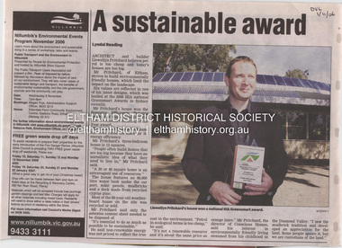
Newspaper article: A sustainable award, Diamond Valley Leader, 1 November2006, Architect and building Llewellyn Pritchard won resource Efficiency Housing Award, finalist in HIA Greensmart Building of the Year Award. House – Environmental Leader (Published: Nillumbik Now and Then / Marguerite Marshall 2008; photographs Alan King with Marguerite Marshall.; p186) In 2006 environmental awareness was mushrooming in the community, which is reflected in the award-winning house at Main Road near Wattletree Road, Eltham. At first sight, the building appears a mix of a classic Eltham mud-brick house and an avant-garde building style. The crown of solar panels stretching along the width of the curved roof, indicates that this is no ordinary house. In fact it signals a new building trend of minimal impact on the environment. Yet it utilises the environment with high technical expertise to achieve comfort and cut running and maintenance costs. In recognition of this, its designer/builder, Conscious Homes, won the 2006 National HIA Greensmart Resource Efficiency Award. For Conscious Homes director, Llewellyn Pritchard, this house reflects a philosophy, strengthened by his connection with Aboriginal culture, through his foster siblings. Pritchard believes the sustainable way indigenous Australians lived and their spiritual connection with land, demonstrates how humanity is part of the ecology. His interest in environmental design stemmed from growing up in bushy Eltham Shire, with its mud-brick tradition. This was followed by studying Architecture at RMIT in the early 1980s, and learning about passive solar design. Pritchard says this house demonstrates that environmental sustainability is not about sacrifice, but about exceptional levels of occupant comfort, savings in running costs and modern fittings and appliances.1 The solar panels on the north roofs are intentionally obvious to make a statement about what the building is doing. But inside the systems are hidden and interactive with conventional services, such as the underground water tank. The house is water and energy self-sufficient and at 12 squares is much smaller than conventional houses, to minimise resources. Yet it accommodates his family of four with three bedrooms, a living/dining and kitchen area and a bathroom/laundry. Importantly the building is designed to last hundreds of years, by being able to be modified as the need arises, such as for commercial use. In this way the structure minimises its environmental impact. The solid double mud-brick walls (which are insulated) include steel beams and supporting frame, allowing the future removal or alteration of any section. The materials are local, recycled and of low toxicity where possible.2 Inside and out, the mud-brick is rendered and sealed with a combination of cement and sand and a mud-based coating in a soft golden hue increases its life. Inside, the golden-brown timber is plantation Mountain Ash and the concrete floors throughout – of local stone aggregate with a clear seal – have a natural looking random stone appearance. The house sustains a stable temperature of around 20 degrees, assisted by the concrete slab floor. The many large double-glazed windows and highlights (windows set high on walls) provide cross-flow ventilation. The north-facing living area maximises heating from the lower winter sun and is cooler in summer, because the sun is higher. Heating comes from a solar hydronic slab system. All appliances and fittings are high efficiency energy or water rated. Appliances in the timber kitchen include a gas stove and a dishwasher, using the building’s own power and water. French doors open from the living area to a deck, concealing the treatment system for all waste water. This is pumped through sub-soil drippers to the indigenous garden beds and no-dig vegetable patch. Below the carport is the 80,000-litre rainwater tank and at the back, the boiler room houses the solar boiler, water tank access, domestic water supply pump, filter gear and hydronic slab heating controls. The solar system is backed up with gas, which is needed to heat water only in winter. Gas used is less than one quarter of that for an average home with ducted heating. Excess power is fed back to the grid and the building uses about one quarter of the mains electricity of an average home. Other local builders have followed Pritchard’s lead in resource efficiency for minimal environmental impact.main road, eltham, businesses, llewellyn pritchard, hia greensmart building of the year award., efficiency housing award, conscious homes australia pty ltd -
 Stawell Historical Society Inc
Photograph, Fluming Water Supply in the Grampians 1991 -- 9 Photos -- Coloured
Coloured photos of Fluming Water Supply in the Grampians. a. Grampians Exit of tunnel through Mt William Range built 1874. b. Halls Gap Fyan's Creek with buried pipe from new diversion Weir Nov 24/91 (Fume Main). c. Halls Gap New Diversion Weir (Keith Phillips) Nov 24/1991. d. Halls Gap Old pipe to open flume adapter Nov 24/1991. e. Halls Gap Old metal open flume Nov24/91. f. Halls Gap Old metal flume and man made stone supporting wall. g. Halls Gap Overhanging rocks above old fume line Nov 24/1991. h. Halls Gap Old pipe to open flume adapter Bill Holmes Nov 24/91. i. Grampians Old hut for controlling flow valves etc. at Stawell side of Mount William Range after tunnel exit. Nine colour photographs of various views around a tunnel through a hill site.grampians water supply flume -
 University of Melbourne, Burnley Campus Archives
Machine - Model machine, Little Giant Pump Co, Model Electric Pump and Flow Meter
Model of an electric pump (No. 7121-4511 Type U21) and Asahi flow meter bolted on to a wooden block. Electric cord. Used for teaching Arboriculture.Oklahoma City, Okla. Little Giant Pump Company U.S. Patent No. 3411450 Clipsal (electric cord.) Asahi Water Meterarboriculture, motor, teaching, ahahi meter, little giant pump company, flow meter -
 Eltham District Historical Society Inc
Film - Video (VHS), Nillumbik Shire Council, The Nillumbik Story, 1996
PART 1 – NILLUMBIK (00:00-07:17) Opening features various scenes around Nillumbik Shire. For 40,000 years Nillumbik was the home of the Wurundjeri people. Robert Hoddle gave the district its name. Jock Ryan, then president of Nillumbik Historical Society discusses the names Nillumbik and Diamond Creek. In the late 1830s white occupation began with gold found in Warrandyte in 1851 and 12 years later at Diamond Creek -the Diamond Reef which led to the Caledonian gold rush. Jock Ryan discusses the Diamond Creek mine, which was thriving until it burnt out in 1915. Large numbers of workmen moved into area in late 1870s to construct the Maroondah Aqueduct. With growing population of Melbourne, the nearby Yan Yean system had severely disrupted the flow of the Plenty River, forcing the closure of three flour mills there. The aqueduct came to the rescue carrying water 66km from Healesville to Preston. When the Diamond Creek gold mine burnt down the local economy suffered but fruit growing industry had already been established and Diamond Creek became a thriving fruit growing centre. Interview with Jack Powell, a long-time fruiterer at St Andrews market, his family had lived in the area for a hundred years, 3 to 4 generations, “a lot of hard work”. By the time the railway arrived fruit growing was no longer competitive. The railway brought the city closer and day trippers. The Green Wedge separates the shire from the more densely developed neighbours such as Whittlesea, Doncaster, Templestowe, Bulleen and Greensborough. Population at the time (1996) was 19,000 but links to the past remain strong. Mudbrick houses along the Heritage Trail The saving of Shillinglaw Cottage from demolition in 1963 and relocation brick by brick. PART 2 – ENVIRONMENT (07:18-14:44) Peter Brock (with Bev Brock in background) at St Andrews market discusses his childhood growing up in the district and the environment and the values it instilled upon him and his own family. The Brocks have been in the district since the 1860s. Nillumbik Shire responsible for managing three catchment areas; Diamond Creek, Arthurs Creek and Watsons Creek. Follows the course of the Diamond Creek commencing in Kinglake through the district to its confluence with the Yarra River at Eltham at Eltham Lower Park. Highlights Eltham Lower Park community revegetation program and the newly constructed (1996) viewing platform built of new and recycled timbers at the confluence of the Diamond Creek and Yarra River. Also featured are outdoor recreation on the river and at Eltham Lower Park including the Diamond Valley miniature railway. Sugarloaf reservoir and recreational activities and fishing. Aerial view of Memorial Park and Shire of Eltham War Memorial tower at Garden Hill, Kangaroo Ground. Significant tourism opportunities for the shire with 3 million potential day-trippers in metropolitan Melbourne. Council and community working together to find a way to promote the shires natural and artistic assets. At Arthurs Creek, the Brock family and neighbours working together to take care of their waterway. Peter Brock’s uncle, Sandy Brock talks about environmental management and the Arthurs Creek Landcare group and actions to eradicate blackberry problem. Having previously planted Cypress rows they are replacing them with indigenous species to improve the water supply, keeping cattle out of the creek bed to improve the quality downstream flowing into the Yarra. Eltham East Primary School Band playing “All things bright and beautiful” merges into scenes of the bushland sanctuary set aside by the school in 1980 with unidentified teacher discusses the sanctuary and their education program and school children’s comments. Plight of a family of Wedgetail eagles nesting in the path of a developer’s bulldozer at North Warrandyte and actions to save their nesting areas. PART 3 – ARTS (14:45-22:00) Arts and Jazz festival at Montsalvat featuring interviews with Sigmund Jorgensen discussing Montsalvat and its principles. Also Matcham Skipper. Clifton Pugh’s funeral at Montsalvat and his legacy at Dunmoochin near Cottlesbridge with artists in residence, at the time, Chicago artist Charles Reddington who discusses the benefits of the experience. An unidentified female artist also talks about the program and why people are drawn to the area. Unidentified man on street talking about the amount of talent in the area, artists, poets, musicians, authors. Artist Ming Mackay (1918-2009) interviewed talking about the people she mixes with on “the Hill”. Works of local artists are displayed Eltham Library Community Gallery and Wiregrass gallery with a new coffee shop at the Wiregrass making it an even more popular destination. Music at St Andrews Hotel (may be a little bit country) and the Saturday market where likely to hear anything. Sellers and patrons at the market asked about what attracts them to the market and where they came from. Scenes of poets/authors giving readings. CREDITS Music by John Greenfield from the CD Sweet Rain “The Snow Tree”, Uncle Music UNC 2001 Cameras - David Mirabella and Peter Farragher Editor – Olwyn Jones Written and Produced by Jason Cameron A Jason Cameron Proction for Nillumbik ShireProvides a record of the relatively newly created Shire of Nillumbik at the time and the features and attactions of the shire in its people arts, culture and environmentVHS Cassette (five copies) DVD (one copy) Converted to MP4 file format 0:22:00, 1.60GBvideo recording, arthurs creek, arthurs creek landcare group, artists, artists in residence, arts, arts festival, authors, blackberry, brock family, bulldozer, bulleen, bushland sanctuary, caledonian gold rush, charles reddington, clifton pugh, cottlesbridge, cypress rows, developer, diamond creek, diamond creek mine, diamond reef, diamond valley miniature railway, doncaster, dunmoochin, education program, eeps, eltham, eltham east primary school, eltham east primary school band, eltham library community gallery, eltham lower park, environment, fishing, flour mill, fruit growing, fruiterer, garden hill, gold mining, green wedge, greensborough, heritage trail, hurstbridge railway line, jazz festival, jock ryan, kangaroo ground, kangaroo ground tower, kinglake, maroondah aqueduct, matcham skipper, memorial park, ming mackay (1918-2009), montsalvat, mudbrick houses, music, musicians, nesting area, nillumbik historical society, nillumbik shire, north warrandyte, old timer, orchards, peter brock, plenty river, poets, population, recreation, recreational activities, revegetation, robert hoddle, sandy brock, shillinglaw cottage, shire of eltham war memorial, sigmund jorgensen, st andrews hotel, st andrews market, sugarloaf reservoir, templestowe, the hill, tourism, viewing platform, warrandyte, water catchment area, watsons creek, wedgetail eagle, whittlesea, wiregrass gallery, wurundjeri, yarra river, jack powell -
 Sunbury Family History and Heritage Society Inc.
Photograph
... of water in Sunbury. It flows from the Macedon Ranges ...The postcard features a view of the Jacksons Creek in Sunbury. Before settlement, Jacksons Creek was the main source of water in Sunbury. It flows from the Macedon Ranges and is an important arm of the Maribyrnong River. A sepia photograph in post card format of a view of a river in the country. JACKSONS CREEK SUNBURYjacksons creek, sunbury -
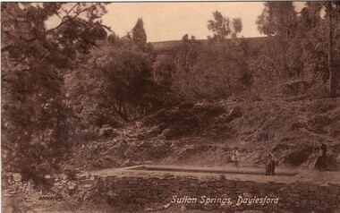 Ballarat Heritage Services
Photograph - Photograph - Black and White, Sutton Spring, Daylesford
Emerging from the base of Wombat Creek Sutton Spring has two mineral water pumps. The spring is named after the Sutton brothers of Cornwell, who discovered it while looking for alluvial gold along Wombat Creek in the 1850s. By 1900, a trench had been dug to expose the spring, and a pipe had been driven through the spring eye. Sandstone rockwork encircled the trench. On 27 February 1907 the Sutton Mineral Spring Reserve was gazetted. By that time the trench had been enlarged and rendered, and a lean-to shelter had been built over the approach track. In 1927 Wombat Creek was rerouted allowing the land around the spring to be cleared and pipework repaired. Five bores were dug in 1929 and equipped with hand pumps. The bores were all shallower than 9.7 m. An attempt was made to replace one of these bores with a new bore, however it was not possible due to ground instability. These two bores are the oldest of all the mineral springs open to the public. Also in 1929 Council contemplated encouraging private enterprise to establish a ‘hydrobath’ similar to those in Europe, after mineral water had been discovered flowing from several other vents in sandstone and slate strata below the typical level of the creek. However, the option was not enacted although at the time to capture the flow another bore to a depth of 15m was sunk. In 1936 architect P. Scott Williams adopted a similar notion and examined the prospect of establishing a Hydropathic establishment above Sutton Springs, assuming a reliable mineral water supply could be found. That idea also lapsed. In October 1997 the Sutton Spring trench was restored to enable the public to again take mineral water at the spring. The restoration included clearing the sides of the creek and removing willow root growth. In 2002 a major overhaul of the trench and its underground works was undertaken and all plumbing replaced. This involved re-routing the creek through sandbagging, covering the spring eye with geofabric and then concrete. Unfortunately due to ongoing water quality issues, public access to take water from the trench was closed, however the trench can still be viewed.A mineral water spring at Daylesford is surrounded by a drystone wall. mineral water, sutton spring, daylesford, central springs, p. scott williams -
 Geoffrey Kaye Museum of Anaesthetic History
Equipment - Inhaler, Hewitt's (modified), Coxeter
Sir Frederick William Hewitt (1857-1916) wrote one of the earliest comprehensive textbooks on anaesthesia, and designed several pieces of anaesthetic equipment. In 1901, he described his wide-bore ether inhaler, a modification of the Clover Ether Inhaler. Unlike the Clover, it can be refilled with ether while still in use, and the mask is screwed into place so that it "cannot be unexpectedly detached." This version is a modified Hewitt's Inhaler which has a narrower 'ways' than the original Hewitt's, and no water compartment. Additionally, one side of the bowl is made of glass which enabled the person administering anaesthesia to see the level remaining in the bowl. Bowl shaped inhaler with a glass bowl base and metal dome top with a connector which appears to be for a rebreather bag. There is a metal switch at the base of the glass bowl to alter or regulate the flow.Stamped into central tube: COXETER LONDON Stamped into side of metal dome: 6460hewitt, wide-bore, clover, ether, anaesthesia, anesthesiology, anaesthesiology -
 Bendigo Historical Society Inc.
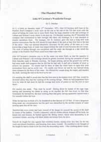
Document - The Flooded Mine, John McCaviston's Escape, April, 2014
Seven men were killed at the Great Extended Hustler's mine disaster on 2nd May 1914 by an explosion of dynamite occurring as the men were waiting at the plat to ascend the mine at the end of their shift. No blame was attached to anyone in the findings of the inquisition. It was unknown what caused the dynamite to explode. Three page typed document by Albert Richardson. Copy of handwritten document. 'The Flooded Mine, John McCaviston's Wonderful Escape' by G. Mackay (History of Bendigo). Article details the events that surrounded the flooding that occurred at the Hustlers Reef Company's mine on 13th December 1873. Water was being drained from the adjoining old workings of Latham and Watson, when the flow increased markedly, causing flooding. John McCaviston was the 'shift boss'., R. Jackson the Manager. McCaviston was saved after spending over 20 hours in a level.3527.2 on bottom of all pages. Duplicate copy. great extended hustlers, goldmining, accident, quartz, mining, flooding of mine, john mccaviston, mine rescue, r. jackson, latham and watson -
 Geoffrey Kaye Museum of Anaesthetic History
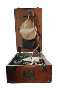
Equipment - Draeger Pulmotor, c.1920
The Dräeger Pulmotor was developed in 1907. It addressed previous concerns about lung injury, by limiting both the inspiratory and expiratory pressures. Although still controversial, the Pulmotor was widely distributed and commercially successful. Oxygen from cylinders provided both the inspiratory gas flow and the driving mechanism. Expiration was an active process and gases were sucked from the lungs by negative pressure created by a Venturi effect. This device came with a facemask and harness, with a caution that the operator should take care to prevent air entering the stomach.Draeger resuscitation kit, inside wooden case with handle. Case contains small heavy gas cylinder with large beige handwritten 'S. M E' inscription on one side. Due to water damage case missing pieces of plywood in corner and floor of case bubbled and swollen.|Rubber decomposed rigidinspiratory, expiratory, pulmotor, negative pressure -
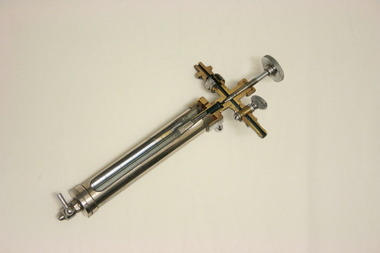 Geoffrey Kaye Museum of Anaesthetic History
Equipment - Sight Feed Type Water Depression Flowmeter, 1925
This object dates back to 1925 and was sectioned by Dr Geoffrey Kaye in 1938. Flowmeters were attached to an anaesthetic machine to measure the flow rate of gas or liquid.Metal cylinder with glass inner chamber and gauge inside. The object has been sectioned for teaching purposes.Inscription on top screw valve. "K/38, Screw Lightly, Oxygen Fine." Inscription on back of top screw valve. "Direct Ox." Inscription on top of flowmeter tube. "G. Kaye fecit. 1938"flowmeter, water depression, gas, sectioned, slight feed, anaesthetic machine -
 The Beechworth Burke Museum
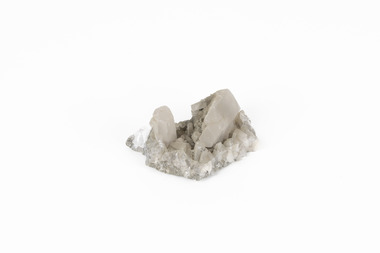
Geological specimen - Calcite crystals
Calcite is a common mineral and is found worldwide due to it being a primary component of many other rocks such as limestone and marble. It is a softer mineral that scratches easily and is often found colourless or with a cream/white shade but may show up in colours such as red, yellow, green, and violet. In sedimentary rocks calcite is often found in the form of invertebrate shells, making it an important biomineral. Calcite is used in many industries such as farming, building, and medicine. This particular specimen was found at Broken Hill mine in Broken Hill, New South Wales, Australia. Broken Hill mine is one of the largest mines working silver and lead in Australia and at its peak employed 6500 staff across 7.5km long of land. The site was founded in 1883 by Charles Rasp, where Rasp and 6 other men from various backgrounds came together to form the first BHP mine. It has become one of the most popular mining sites due to its abundance and longevity. The ore body was created 1685 million years ago due to volcanic activity causing heated seawater to flow up through the seafloor where it mixed with the cold water creating black sulphide precipitates. These then settled back onto the seafloor forming sediment layers rich in minerals. Over time the land eroded until it was discoverable by humans.Historically this specimen is significant due to the origin of its location. Broken Hill mine has a long history in both its location and its findings and has resulted in a variety of minerals being discovered at its site. It is beneficial in the understanding of the Australian landscape over millions of years. Due to its properties, calcite today is used in a multitude of different industries such as agriculture, construction, medicine, and farming.A small sized calcium, carbon and oxygen made mineral specimen in shades cream and greycalcite, mineral, limestone, marble, sedimentary, invertebrate shells, biomineral, farming, medicine, broken hill, broken hill mine, new south wales, charles rasp, syndicate of seven, volcanic activity, black sulphide precipitates, calcite crystals, beechworth museum, indigo shire, beechworth -
 Merri-bek City Council
Photograph - Digital print on photographic paper, Maree Clarke, The Long Journey Home 4, 2024
-
 Merri-bek City Council
Photograph - Digital print on photographic paper, Maree Clarke, The Long Journey Home 9, 2024