Showing 8512 items
matching water-flow
-
 Wodonga & District Historical Society Inc
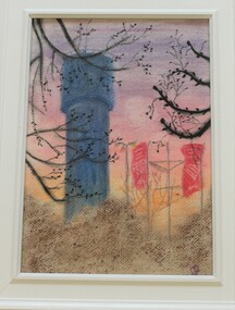
Drawing - Water Tower, Wodonga, 2020
THE WATER TOWER is a major landmark of High Street, Wodonga. It began operation from 1924 until it ceased operation in 1959. It stood unused for a decade until the lower section was modified and put to use as “ The Tower’s Cobbler’s Inn” in 1962. In 1972 Wodonga City Council proposed to demolish the Tower. Their suggestion received an unfavorable response from the city’s citizens, so the Tower still stands today.Donated by Dr. Imalka WettesingeRepresentation of the Water Tower in High Street, Wodonga in white framewodonga water tower, scenic features wodonga -
 Tatura Irrigation & Wartime Camps Museum
Book, Rodney Irrigation (A Diary of a Water Guard), 1891
Booik used as a diary for work as a channel and water guardMaroon and red mottled coloured book with maroon spine binding. Blue paper inside book. Handwritten in pen and inkInside back page :- Rodney Irrigation & Water Supply Trust overseer in charge of Girgarre & Girgarre East of Mt. Scobie channels. Memorandum book.rodney irrigation, diary of a water guard, irrigation, payten r, tatura, books, history, local -
 Stawell Historical Society Inc
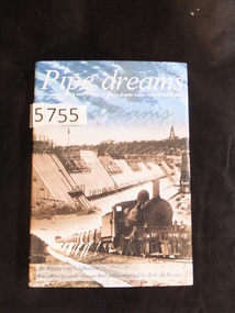
Book, Rhona van Veldhuisen, Pipe Dreams, A stroll through the history of water supply in the Wimmera Mallee, 2001
A History of Domestic and Stock Water supply in the Wimmera Mallee from 1836 to 1997Blue Hard Cover with Gold Print. Dust Jacket. Blue sky with clouds above b/W/ dam wall under construction, steam Train in foregound Pipe dreams A stroll through the history of water supply in the Wimmera Mallee. By Rhonda van Veldhuisen based on records researched by Bob McIIvenastawell water supply -
 Linton and District Historical Society Inc
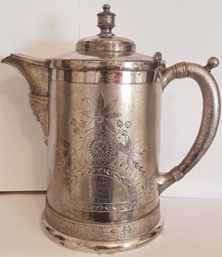
Trophy, Simpson Hall Miller and Co, Water Jug, Linton Fire Brigade, 1885, 1885
Won by Linton Fire Brigade in 1885. (3rd prize NFBAD Ballarat). Found on Linton tip by James Wishart in the 1960s. Mr Wishart donated the water jug to LDHS shortly before his death in 1982.Large, silver-plated water jug, with hinged lid. Flower pattern etched on front and back, with inscriptions."N.F.B.A.D-Ballarat 1885-3rd Prize-Engine practice for 8 men / Won by Linton Fire Brigade / P Wishart D Cornish S Ball J Chung". "Simpson, Hall, Miller and Co. Plate 26".linton fire brigade, p. wishart, d. cornish, s. ball, j. chung, trophies, water jugs -
 Charlton Golden Grains Museum Inc
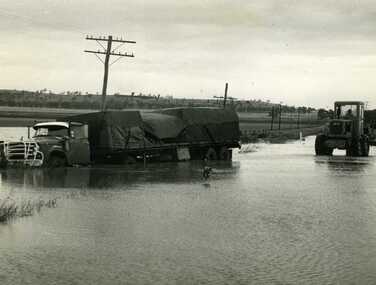
Photograph, Cameron, Ian, Road Transport run off road in flood water 1971, 12/11/1971
Road transport run off Calder Highway in 1971 flood water. Shire grader trying to remove truck. Used in Charlton Tribune Nov 12th, 1971.B/W photo of road transport run off Highway in flood water. Shire grader trying to remove truck.flood, calder highway, charlton -
 Orbost & District Historical Society
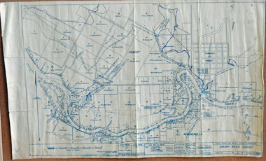
survey, 1941
this item is a useful reference tool.A survey map produced by the State Rivers and Water Supply Commission. It is on white paper with blue ink. It is a hand-drawn survey of the Snowy River in 1939-40.survey map snowy-river -
 Flagstaff Hill Maritime Museum and Village
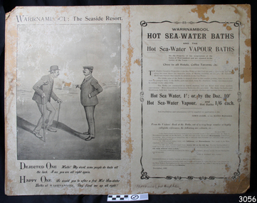
Poster - Recreation, Warrnambool Hot Sea Water Baths, c. November 1908
The poster includes a cartoon by Arthur Jordan, with a conversation between an ailing man and a good man after baths visits. There are several reviews dating from 1906 to 1908 extolling the healing powers of the baths' waters. In February 1877 a Baths Company (1050 shares) was formed in the town of Warrnambool for the establishment of the baths at the south end of Gillies Street. The baths were filled with sea water from Lady Bay, originally pumped by a windmill situated near the current Surf Lifesaving Club and carried by iron pipes to the Public Baths; later the water was pumped by gas motor. Hot and cold fresh water baths were advertised. The gentlemen’s bath was 100 feet long and 50 feet wide, of graduating depth. A second bath, solely for ladies, was 60 feet long by 30 feet wide. Hot Sea-water Baths were also part of the institution, and were sought after for their ‘wonderful curative powers’, and ‘incomparable’ as a ‘tonic for the feeble’. In June 1881 the Hot Sea Baths were opened, and both hot and cold water baths were supplied at reasonable charges. Patrons came from near and far to receive the benefits. The manager of the Baths was J. Kirkpatrick. The Baths Company struggled for several years without success so in 1883 the baths were sold to the Borough Council for 1250 pounds. The original shareholders received nothing for their outlay; the overdraught was over the sale price. In May 1884 the Council announced that an estimated they has spent 1000 pounds in improving the baths since purchasing them and were now returning an income of 11 per cent. The poster promotes the healing powers of the hot sea water baths that were in use in Warrnambool in the late 19th century through to the early 20th century. The baths were a place for fitness, health and social activity, an example of the recreational activities during this period.Poster, black and white, mounted on card. It shows advertising Warrnambool Sea-water Baths and Hot Sea-water Baths. There are several references promoting the health benefits of baths, dating from 1906-1908. The cartoon was sketched by Arthur Jordan. The poster was printed by The Thompson Printing Co. Warrnambool. Handwritten inscription on the lower edge.Handwritten "10,000 mailed by post through Victoria"flagstaff hill, warrnambool, shipwrecked-coast, flagstaff-hill, flagstaff-hill-maritime-museum, maritime-museum, shipwreck-coast, flagstaff-hill-maritime-village, warrnambool salt baths, warrnambool therapudic baths, arthur jordan, baths company, sea water baths, hot sea water, swimming, healing powers, warrnambool baths, advertisement, thompson printing co. warrnambool -
 Orbost & District Historical Society
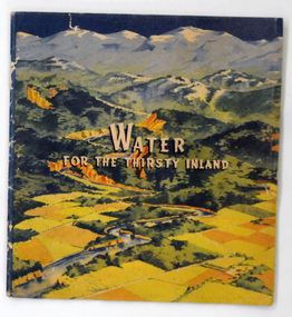
book, Water For the Thirsty Inland, 1945
Water For the Thirsty Inland was published by The Murrumbidgee Valley Water Users Association as a case for diversion of part of the Snowy River waters to the Murrumbidgee. In 1950 The Murrumbidgee Valley Water Users Association and the League established the Murray-Murrumbidgee Development Committee to ensure the Snowy Scheme was completed.This book is a significant research tool for the history of the diversion of the Snowy River.A 44 pp book, titled Water For The Thirsty Inland. On the front cover is a coloured print of a painting of a river (Snowy River?) from the mountains to the flats. The text of the title is white with a black shadow. The book contains b/w photographs and the print is black and green.Some pencilled notes on back.snowy-river murrumbidgee-valley-water-users' irrigation -
Whitehorse Historical Society Inc.
Pamphlet, Victoria's Water Resources
Pamphlet by Ministry of Water Resources and Water Supply for Use Water Wisely Campaign.Pamphlet by Ministry of Water Resources and Water Supply for Use Water Wisely Campaign.Pamphlet by Ministry of Water Resources and Water Supply for Use Water Wisely Campaign.water supply, victoria. ministry of water resources and water supply, melbourne and metropolitan board of works, state rivers and water supply commission -
 Ballarat Heritage Services
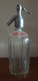
Domestic object - Soda Syphon, Schweppes Soda Water Syphon
Glass botte with metal 'Schweppes' soda syphon. "Schweppes Soda Water"soda syphon, schweppes soda water, soda water syphon -
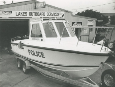 Lakes Entrance Historical Society
Photograph - Water Police boat for WA, Lakes Post Newspaper, 1/06/1996 12:00:00 AM
new Water Police boat for WA on trailer outside Lakes Outboard Services Princes Highway Lakes Entrance Victoria. Hull was built at Bairnsdale. Lakes Entrance Outboard Specialists David Newton and Mark Frost fitted motors.Black and white photograph of new Water Police boat for WA on trailer outside Lakes Outboard Services Princes Highway Lakes Entrance Victoriapolice, boats and boating, boat building -
 Tatura Irrigation & Wartime Camps Museum
Album - Photograph album, Tatura Water Tower Mural Project
Book presented to the Museum from Tatura RSL showing the work that went into creating the Tatura Water Tower Mural. The Water tower on the north side, depict a full size picture of Sir John Monash in uniform. The south side of the tower depicts a thread of poppies. Sir John was the engineer who designed the water tower which was opened in 1912. A letter from Tatura RSL is in the book.White hard covered book. Front has two pictures of a water tower. One has poppies on it and the other a man in Army uniform. Back cover has to picture of part of a building with Victory Hall on it and the Australian flag up a flag pole flying.tatura rsl, tatura water tower mural, sir john monash, water tower engineers -
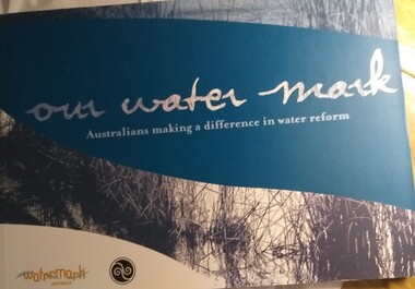 Tatura Irrigation & Wartime Camps Museum
Book, Our Water Mark
Information regarding water in Australia, its uses, climate change, agriculture.Soft covered book, picture of water and reeds with a blue swipe through with title of book in white. Bottom left has a white mark with watermark Australia in gold. Spine is blue with white writing. Back is blue with white writing. irrigation, water in australia -
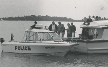 Lakes Entrance Historical Society
Photograph - water police search and rescue boat, Lakes Post Newspaper, 8/01/1992 12:00:00 AM
water police search and rescue boat and searchers for Gavin Page who's body was found on thirteenth January accident occurred on Seventh January Gippsland Lakes VictoriaBlack and white photograph of water police search and rescue boat and searchers for Gavin Page who's body was found on thirteenth January accident occurred on Seventh January Gippsland Lakes Victoriapolice, social history, gippsland lakes -
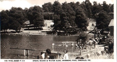 Emerald Museum & Nobelius Heritage Park
Postcard - B/W, Spring Board and Water Slide, Swimming Pool, Emerald, Vic
Recreational activities and provisions at Emerald Park Lake circa 1940sPostcard made from black and white photograph. Many bathers at Emerald Park Lake Swimming Pool. Springboard in foreground, water slide on right to the rear. FRONT: 'The Rose Series', P 519 COPYRIGHT' 'Springboard & Water Slide, Swimming Pool, Emerald, Vic.' REAR: Rose illustration in centre, flanked by 'POST CARD' and "The "Rose" Series Deluxe', 'A Real Photograph Produced in Australia'. Along left: 'Published by the Rose Stereograph Co., Armadale, Victoria'.emerald park lake, rose series, swimming pool -
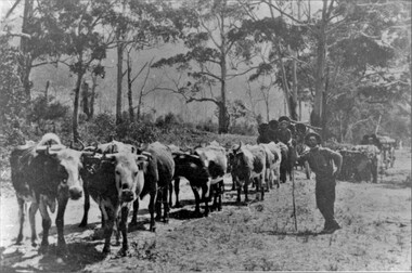 Stawell Historical Society Inc
Photograph, Two Bullock Teams with loads of Water Pipes at Halls Gap
Two Bullock Teams pulling loads of Water Pipes at Halls Gap. Bush scene showing two bullock teams loaded with water pipes. Three men in the photo, two men on the pipe wagons, one standing leaning on a stick beside the team of bullocks. There are two black and white photos one small the other an enlargement.stawell water supply -
Tatura Irrigation & Wartime Camps Museum
Map, State Rivers and Water Supply Commission, Goulburn Irrigation System, C 1940
A map showing the extent of Goulburn irrigation C. 1940. Also indicated by shading are: natural water resources, proposed extensions, existing stock and domestic supply areas, reservoirs, main channels, principal distribution channels, and railways.Irrigation Rivers Victoria.irrigation, victoria state rivers and water supply commission, map -
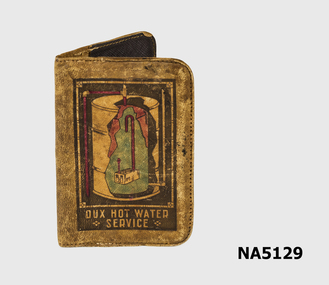 Whitehorse Historical Society Inc.
Functional object - Notebook Cover, 1968
1968 Dux Hot Water Service note book - advertising the water service.Leather notebook holder with illustration of hot water service on the cover."Dux Hot Water Service" with hot water service depicted in colour.dux water service -
4th/19th Prince of Wales's Light Horse Regiment Unit History Room
Booklet, The Assault Crossing of Water Obstacles. Military Training Pam No 20 Part II Water Crossing Equipment 1947, 1947
A soft covered booklet to provide the unit commander and staff officer with information on available types of water crossing equipmentWO Code No 8231assault water crossings -
Stawell Historical Society Inc
Archive, Stawell Water Supply. Foreman’s Reports 1949 – 1959, 14/6/1949 - 20/5/1959
Heavy Card Cover - Leather Trim. Fawn in ColourForeman's Reports. Stawell Water Supplystawell -
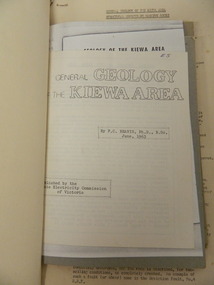 Kiewa Valley Historical Society
Folder - Kiewa Valley, Geology, Plant Life, Bird Life, Water Cycle, 1960's
Studies of geology, plant and bird life and water cycle in the early 1960's.Value for study and comparing to current plant and bird life and the water cycle. Geology gives reason for the construction of the Kiewa Hydro Electric Scheme - the use of materials and the locations.Black foolscap 'bend back' folder which holds papers on: Geology, Flora, Orchids, Birds and three booklets: 1. Royal Soc. of Vic. by E.C.Beavis Sept. 1961 - Geology 2. Royal Soc. of Vic. by E.C.Beavis July 1960 Mylonites 3. The Water Cycle in Action / Bogong High Plains by Phyllis Reichl kiewa valley; geology; plant life; bird life; water cycle; kiewa hydro electric scheme -
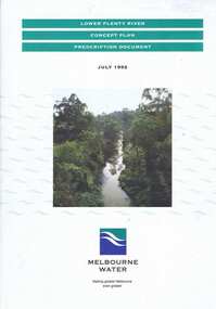 Greensborough Historical Society
Book, Lower Plenty River concept plan: prescription document, 1992_07
Draft concept plan prepared. by Brett Cheatley, Malcolm Warren and Ian Womersley, Parks and Waterways Planning Division, Melbourne Water. Includes management areas and key strategies for the Lower Plenty River.Book, mainly black and white print, colour photographs and plans, 66 pages. 3 copiesplenty river, melbourne water, lower plenty river -
 Greensborough Historical Society
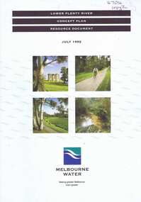
Book, Lower Plenty River concept plan: resource document, 1992_07
Draft concept plan prepared by Brett Cheatley, Malcolm Warren and Ian Womersley, Parks and Waterways Planning Division, Melbourne Water. This document includes information on the heritage and environment of the Lower Plenty River.Book, mainly black and white, colour photographs and plans, 56 pages, 3 copies.plenty river, melbourne water, lower plenty river -
 Wodonga & District Historical Society Inc
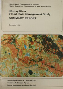
Book - Murray River Flood Management Study December 1986 - Summary Report, Rural Water Commission of Victoria
This publication is the Summary Report of a study of the management of water resources and management of the Murray River. It was jointly commission by the Rural Water Commission of Victoria and the Water Resources Commission of New South Wales. The Rural Water Commission of Victoria was established in 1984. The Commission was renamed in 1992, becoming the Rural Water Corporation. The Water Resources Commission of NSW was constituted in 1976. The Water Administration Act, 1986 abolished the Water Resources Commission replacing it with the Department of Water Resources on 1 January 1987.non-fictionThis publication is the Summary Report of a study of the management of water resources and management of the Murray River. It was jointly commission by the Rural Water Commission of Victoria and the Water Resources Commission of New South Wales. The Rural Water Commission of Victoria was established in 1984. The Commission was renamed in 1992, becoming the Rural Water Corporation. The Water Resources Commission of NSW was constituted in 1976. The Water Administration Act, 1986 abolished the Water Resources Commission replacing it with the Department of Water Resources on 1 January 1987. floodplain management -- murray river, water resources -
 National Vietnam Veterans Museum (NVVM)
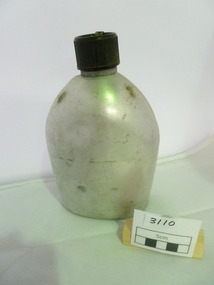
Equipment - Equipment, Army, Water Bottle
Aluminium water bottlewater bottle, sas -
 Whitehorse Historical Society Inc.
Photograph, Schwerkolt Cottage showing Old Well, Toilet and Old Water Tank, 1962
Photo sent to Mary Jack, Pittsburgh USA, by Charles Schwerkolt. Accompanying text by Charles - 'This is the end facing Ernie's old house which was burnt down last year. There is also the remains of the old well. The old smoke house used to be down there also. All these things have disappeared a long time ago. The house is the only thing that remains of the Schwerkolt property. The wine cellars and other buildings fell down years ago after the bush fires burnt the wooden supports. You will notice the toilet has about 3 boards off the top. The old water tank is hiding the back.Black and white photo of Schwerkolt Cottage showing Old Well, Toilet (with boards missing) and Old Water Tank. Thin Black Border.schwerkolt, charles clarence victor, whalen, rosalie, jackschowsky, mary elizabeth, schwerkolt cottage -
 Warrnambool and District Historical Society Inc.
Map, Soil conservation authority:plan of high water marks at Lady Bay Warrnambool, 1984
This map documents the changing state of Lady Bay from around 1870 until 1976. It depicts the changing high water mark over that period and the main outlet of the Merri River in 1872 and 1976.This map provides a useful and significant insight into the ever changing face of Lady Bay from the 1870’s through to 1980’s. Cream paper map drawn with black ink showing Lady Bay and South Warrnambool section of Warrnambool. In lower RH corner Soil conservation AuthorityPlan of High water marks at Lady Bay Warrnambool. Drawn P.D. 19.1/84. Scale 1:3600. Written on back in black pencil: Lady Bay Historical HWM lady bay map, merri river 1872- 1976, merri river 1872- 1976, history of warrnambool -
 Greensborough Historical Society
Document - Report, Rhys Coleman, The Health of the Plenty River Catchment 1999, 1999_09
Report prepared by Rhys Coleman for Waterways and Drainage, Melbourne Water Corporation, discusses the health of the Plenty River catchment from upstream of Toorourrong Reservoir, through Whittlesea and Mernda, South Morang and Plenty to Greensborough and confluence with the Yarra River.31 p., tables.plenty river, melbourne water corporation -
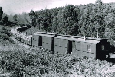 Otway Districts Historical Society
Photograph, R. Preston, Taking water at Wimba tank, 8 January 1958
Wimba station is 37.3 km south of Colac. This station, originally called "Bunding", opened with the line in in March, 1902, as an unnamed stopping place. It was renamed "Wimba" on 17 November, 1902. A water tank for locomotive requirements was placed on the side of a hill about 100 metres south of the station. Wimba was not provided with a loop siding but had a passenger shelter until 1936 when the roads took over. A sheep race was provided near the passenger shelter. The station closed with the line.B/W. An UP goods train loaded with pulp wood on NQR wagons and two NC guard's vans taking water at Wimba tank on 8 January 1958. wimba; railways; -
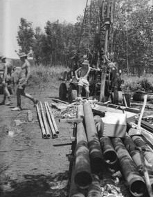 National Vietnam Veterans Museum (NVVM)
Photograph, Gibbons, Denis, Boring For Water
Denis Gibbons (1937 – 2011) Trained with the Australian Army, before travelling to Vietnam in January 1966, Denis stayed with the 1st Australian Task Force in Nui Dat working as a photographer. For almost five years Gibbons toured with nine Australian infantry battalions, posting compelling war images from within many combat zones before being flown out in late November 1970 after sustaining injuries. The images held within the National Vietnam Veterans Museum make up the Gibbons Collection.A black and white photograph of the drilling for water at the 1st Australian Task Force Base, Nui Dat, Phouc tuy Province. The Engineers prepared to install sealed water pipes to carry ground water to the base water purification works, already under construction. (Circa November 1966)photograph, 1st atf base, engineers, 17 const sqn, nui dat, phuoc tuy province, gibbons collection catalogue, denis gibbons, photographer, vietnam war