Showing 2841 items
matching wests road
-
 Bendigo Historical Society Inc.
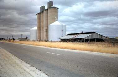
Slide - MOUAT CRAWFORD COLLECTION: FARMING IN THE WIMMERA, c1963
... along side the road. Markings; West Silos Litchfield. MAR 63... in the Wimmera. Silos situated along side the road. Markings; West Silos ...Mouat Collection - Farming in the Wimmera. Silos situated along side the road. Markings; West Silos Litchfield. MAR 63. Used as a teaching aid.kodakagriculture, farm, crop storage -
 Eltham District Historical Society Inc
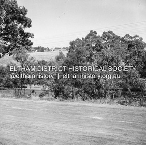
Negative - Photograph, J.A. McDonald, Eltham-Yarra Glen Road, Lower Plenty, c. July 1962
... View looking west across Old Eltham Road to the Eltham... melbourne View looking west across Old Eltham Road to the Eltham ...View looking west across Old Eltham Road to the Eltham-Yarra Glen RoadRecord of various Shire of Eltham infrastructure works undertaken during the period of 1952-1962 involving bridge and road reconstruction projects, sometimes with Eltham Shire Council Project Reference numbers quoted. It was during this period that a number of significant improvements were made to roads and new bridges constructed within the shire that remain in place as of present day (2022). In many situations, the photos provide a tangible visible record of infrastructure that existed throughout the early days of the Shire. The album was put together by or under the direction of the Shire Engineer, J.A. McDonald.1962-07, eltham-yarra glen road, infrastructure, lower plenty, lower plenty road, road construction, shire of eltham, old eltham road -
 Melbourne Tram Museum
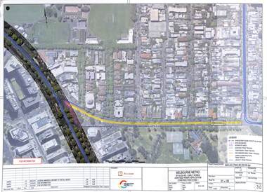
Drawing - Set of 5, Melbourne Metrorail, "Melbourne Metro St Kilda Road - early works", 10/2016
... to Toorak Road West and St Kilda Road. Drawings prepared... to Toorak Road West and St Kilda Road. Drawings prepared ...Drawings prepared by the Melbourne Metro project to show the relocation of Domain Interchange, Domain Road and Park St South Yarra to Toorak Road West and St Kilda Road. Drawings prepared for a Heritage Victoria application dated 26/10/2016. Shows the various work stages principally at the site of Domain Junction where the tram tracks had to be relocated to facilitate the construction of Anzac station.Yields information about the relocation of Domain Interchange to facilitate the construction of the Melbourne Metro.Set of five laminated A3 colour prints with a punch hole in the top left hand corner.metro tunnel, domain interchange, domain road, toorak road, st kilda road, heritage victoria, anzac station -
 Ringwood and District Historical Society
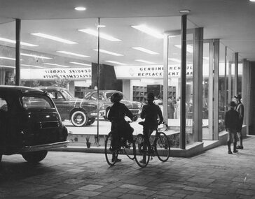
Photograph, Maroondah Highway West, Ringwood, c1970. New showroom of H. G. McLean Motors
... , in Whitehorse Road, West end, Ringwood."... showroom of H. G. McLean Motors, in Whitehorse Road, West end ...Black and white photographTyped on backing sheet, "Something new in Ringwood's night scenery - the glamorous new showroom of H. G. McLean Motors, in Whitehorse Road, West end, Ringwood." -
 Glenelg Shire Council Cultural Collection
Photograph - Photograph - Oil tanks, n.d
... Black and white photograph of shell oil tanks, west side... of shell oil tanks, west side of Wellington Road taken from port ...Port of Portland Authority Archivesport of portland -
Glenelg Shire Council Cultural Collection
Photograph - Photograph - Oil tanks, n.d
... Black and white photograph of shell oil tanks, west side... Cliff Street Portland great-ocean-road Port of Portland ...Port of Portland Authority ArchivesBack: M, D '80 in pencilport of portland -
Glenelg Shire Council Cultural Collection
Photograph, Oil tanks, n.d
... Black and white photograph of shell oil tanks, west side..., west side of Wellington Road taken from port area. Railway ...Port of Portland Authority Archives -
 Whitehorse Historical Society Inc.
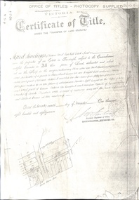
Document - Land Title, Certificate of Title, 29/11/1887
... on the north-west corner of Whitehorse Road and Mitcham Road including... on the north-west corner of Whitehorse Road and Mitcham Road including ...Photocopies of land titles involved in subdivision of land on the north-west corner of Whitehorse Road and Mitcham Road including Britannia Street. A list of purchasers is included.mitcham road, mitcham, whitehorse road, britannia street, rawlings, alfred, frost, john, richards, thomas, leech, george arthur, smith, reed, richard louis, young, frederick, hughes, doery, george henry, mitcham primary school, no. 2904, land subdivision -
 Whitehorse Historical Society Inc.
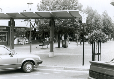
Photograph, Mitcham Mall, 5/01/2001 12:00:00 AM
... North West. Taken from Whitehorse Road. Shops in background...Whitehorse Historical Society Inc. 2-10 Deep Creek Road ...Black and white photo of Mitcham Mall, Mitcham, looking North West. Taken from Whitehorse Road. Shops in background on previous site of Barelli's bakehouse.britannia mall mitcham -
Canterbury History Group
Photograph - Canterbury Road, Canterbury, c1910
... View from Wattle Valley Road of Canterbury Road looking... Road of Canterbury Road looking west. Canterbury Mansions ...View from Wattle Valley Road of Canterbury Road looking west. Canterbury Mansions, built 1889 as the Canterbury Club Hotel for William Malone is on left.canterbury, canterbury road, railway crossing, canterbury mansions, horse drawn vehicles, goldings hall -
 City of Kingston
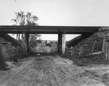
Photograph - Black and white, c. 1920
... Road, looking west. A car has stopped on the road... of an unsealed underpass at Patterson Road, looking west. A car has ...This image is part of a larger collection of images from the Public Transport Corporation displaying train stations and streetscapes in what is now the City of Kingston.While the focus of this image is the train line running overhead, the unsealed nature of the road speaks to the progression of suburban development during the 1920s.Black and white image of an unsealed underpass at Patterson Road, looking west. A car has stopped on the road in the distance and man is standing on the duckboard leaning into the car.Round white sticker on reverse with black printed text: 177 Handwritten in red ink: 60% Blue ink stamped on reverse: COPYRIGHT / Public Transport Corporation / For re-ordering photographs / Please quote negative No ADV 300 / Enquiries C/- PTC Photographic Unit / Telephone switchboard 619 111patterson road, railway, trains, cars, unsealed roads -
 Whitehorse Historical Society Inc.
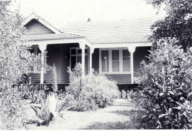
Photograph - B/W Photograph, Mitcham House, 1/09/1976 12:00:00 AM
... Black and white photo of dwelling on north-west corner... of dwelling on north-west corner of Mitcham Road and Delhi Street ...Black and white photo of dwelling on north-west corner of Mitcham Road and Delhi Street, Mitcham has been demolished and replaced with two brick units.mitcham road, mitcham, delhi street -
 Bendigo Historical Society Inc.
Book - THE DIARIES OF RICHARD POPE, 1892
... by John F.H. Westly, 39 Craig Road, Donvale. Victoria & Panguna... October 1889 - 20 July 1892' Edited by John F.H. Westly, 39 Craig ...The Diaries of Richard Pope, Volume VIII, Broken Hill, Bendigo, Kadina, Moonta, 16 October 1889 - 20 July 1892' Edited by John F.H. Westly, 39 Craig Road, Donvale. Victoria & Panguna , Bougainville, PNG.Richard Popebendigo, history, diaries of richard pope, bendigo, broken hill, kadina, moonta.goldfields, mining, richard pope -
 Ringwood and District Historical Society
Map - State Aerial Survey, Dandenong Ranges Area, Parishes of Warrandyte and Ringwood - 1956
... ). Ballyduffy Estate streets include City Road, West Prussia Road, Duffy... Estate streets include City Road, West Prussia Road, Duffy Street ...Map of central and southern areas of Ringwood and part of Ringwood East and Heathmont compiled by Dept of Lands and Survey, July 1956, from aerial photographs and Cadastral Survey information. Subsequent hand-drawn addition of streets showing layout of "Township of Ballyduffy Estate 1858-60", an earlier proposed subdivision that did not eventuate. (See attached 5009b Ballyshanassy_ Melbourne’s lost suburb.pdf for Ballyduffy historical naming relevance). Ballyduffy Estate streets include City Road, West Prussia Road, Duffy Street, Ireland Street, Evans Street, Victoria Street, Regina Street, Short Road, Prussia Road, Duffy Street East, Ireland Street East, Evans Street East, Chapman Street. Misc Topo 93 Sheet 22, Ringwood A4B2. Scale: 4 chains to 1 inch. Contour interval 20 feet. -
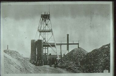 Bendigo Historical Society Inc.
Slide - ALBERT RICHARDSON COLLECTION: SPECIMEN HILL, EAGLEHAWK
... Slide. Specimen Hill, Eaglehawk, west of Sailor's Gully..., west of Sailor's Gully Road. Image taken about 1906. Poppet ...Slide. Specimen Hill, Eaglehawk, west of Sailor's Gully Road. Image taken about 1906. Poppet head, chimney stack, mullock heaps, ore bins.No. 22 on bottom of slidemine, gold, specimen hill (eaglehawk )., bendigo mines-jack hattam collection -
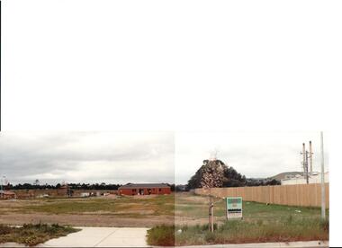 Hume City Civic Collection
Photograph, early 1990s
... in Anderson Road looking west towards Elizabeth Drive and the leisure... in Anderson Road looking west towards Elizabeth Drive and the leisure ...The series of 5 photographs feature different views of the Woodlands housing development which opened up land bounded by Gap and Anderson Roads, Cornish Street and Elizabeth Drive in the early 1990s. It was a large housing development built close to Sunbury township.A coloured photograph of a new housing development taken in Anderson Road looking west towards Elizabeth Drive and the leisure centre. Some housing construction is in the middle distance.housing developments, anderson road, george evans collection -
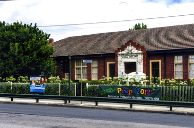 Whitehorse Historical Society Inc.
Photograph, Mitcham State School No 2904, 2012
... on the west side of Mitcham Road, opposite East Doncaster Road. Sign... on the west side of Mitcham Road, opposite East Doncaster Road. Sign ...See NP3945Coloured photograph of the Mitcham State School situated on the west side of Mitcham Road, opposite East Doncaster Road. Sign on the fence requesting 2012 prep enrolments.mitcham state school no 2904, state schools -
 Eltham District Historical Society Inc
Slide, Shire of Eltham War Memorial Tower, Eltham-Yarra Glen Road, Kangaroo Ground, 24 Jul 1973
... Viewed from Eltham-Yarra Glen Road looking west from near... melbourne Viewed from Eltham-Yarra Glen Road looking west from near ...Viewed from Eltham-Yarra Glen Road looking west from near Garden Hill Ct.35 mm colour positive transparency x 6 Mount - Agfacolor Service (Blue)kangaroo ground, shire of eltham, war memorial tower, eltham-yarra glen road, shire of eltham war memorial -
Mission to Seafarers Victoria
Letter - Correspondence, 1947
... , 140 Brunswick Road, West Brunswick, Victoria and stamped..., 140 Brunswick Road, West Brunswick, Victoria and stamped ...Quinn CollectionBuff-coloured typed air-letter 0366a1) written on board S.S.Morgenster, at sea, dated 28/12/47. There are two air mail stickers attached - one to the upper left edge and the other to the upper left side. Air letter is addressed to Mrs S Quinn, C/- Mrs Blackmore, 140 Brunswick Road, West Brunswick, Victoria and stamped with a blue Correo Aereo Replublica Argentina stamp.letters-from-abroad, quinn, s.s.morgenster, 1947 -
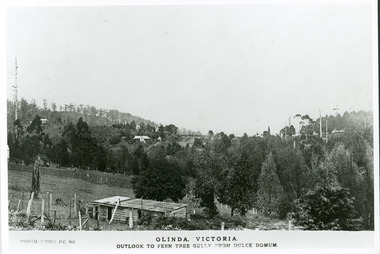 Mt Dandenong & District Historical Society Inc.
Photograph, Olinda, Victoria. Outlook to Ferntree Gully from Dulce Domun
... Copy of Photo Series postcard #965 with view looking west... with view looking west to Mt Dandenong Road and Ridge Road. Looking ...Rose Series Postcard number 965Copy of Photo Series postcard #965 with view looking west to Mt Dandenong Road and Ridge Road. Looking across to where the Log Cabin (Kellys) would now be.mount dandenong, dulce domum, photo series -
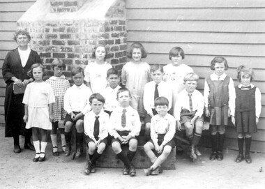 Surrey Hills Historical Society Collection
Photograph, Miss Susan Kelsall's school, Canterbury Road, Surrey Hills, 1925
... for her, at 426 Canterbury Road, just west of Warrigal Road... built for her, at 426 Canterbury Road, just west of Warrigal ...Date is approximate. The teacher is presumed to be Miss Susan Kelsall; 3 of the children are identified as: Back row left: Thora Holmes Back row right: Gwen Evans and Betty Austin. Miss Kelsall was registered as a primary and music teacher in 1908. In 1919 she had a school at Wyclif Church in Norfolk Road. From 1924-1930 the school was in the hall, perhaps built for her, at 426 Canterbury Road, just west of Warrigal Road. This was demolished in 1985; a gum tree marked the spot.Black and white photo of a teacher holding a book and 3 rows of children in front of a weatherboard wall with a brick chimney protruding from the wall. The children are not in uniform although a couple of the girls are wearing tunics and all the boys are wearing ties. independent schools, schools, primary education, music, miss susan kelsall, miss gwen evans, miss betty austin, miss thora holmes, mrs betty harvey -
Surrey Hills Historical Society Collection
Work on paper - Vertical file on Back Creek, Surrey Hills
... Riversdale Road just west of Through Road. ... Riversdale Road just west of Through Road. Back Creek A vertical file ...Back Creek is one of the tributaries of Gardiners Creek. It rises as a spring on the slopes of the hill at the corner of Canterbury Road and Elgar Road in Surrey Hills, the location of a Melbourne Water tower and reservoir. It has been channelled underground from this point in pipes as far as Union Road. South Surrey Park runs along both sides of Back Creek from where the creek crosses Union Rd near Rose Avenue to where it crosses Riversdale Road just west of Through Road. A vertical file containing information about Back Creek in Surrey Hills: 1. 4 colour photos taken in 1983 (1 page). 2. ‘Pipe dreams run their course’, (Boroondara Review ?) 17.4.2013 (1 page). 3. ‘Plan rainchecked for creek impact’, Boroondara Review, 13.3.2013 (2 pages). back creek -
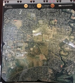 Greensborough Historical Society
Aerial Photograph, AAM Photographics, Heidelberg AAM1969c 086, 24/11/1991
... Yallambie Road; West boundary Hurstbridge railway.... & Yallambie. North boundary Yallambie Road; West boundary Hurstbridge ...One of a series of four overlapping aerial photographs of the Heidelberg/Greensborough areas in 1991, covering Simpson Barracks, Macleod, Rosanna, Viewbank, Watsonia & Yallambie. North boundary Yallambie Road; West boundary Hurstbridge railway.Laminated colour aerial photographssimpson barracks, yallambie, watsonia, macleod, rosanna, viewbank -
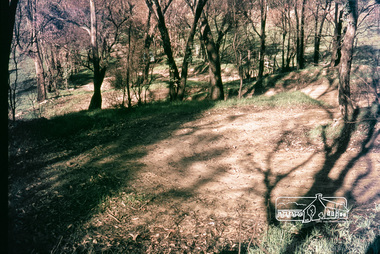 Eltham District Historical Society Inc
Photograph, Russell Yeoman, Construction of fire access on Gumtree Road, Research, by Army Reserve Engineers under command of Captain Bill Oakley, c.1966, 1966c
... from west looking east. Road had more zigs and zags in those... from west looking east. Road had more zigs and zags in those ...Bill Oakley was an engineer at the Shire of Eltham. Viewed from west looking east. Road had more zigs and zags in those days on the west side. Russell Yeoman's FC Holden visible at bottom of hill. Digital file only; created from original colour positive slide transparencyresearch (vic.), russell yeoman collection, gumtree road, army reserve engineers, captain bill oakley, fc holden sedan, fire access, streets -
 Eltham District Historical Society Inc
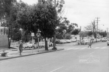
Photograph, Looking northwest acroos Main Road from near Arthur Street, Eltham, February 1968, Feb 1968
... Shows the car parking on the west side of Main Road, part... melbourne Shows the car parking on the west side of Main Road, part ...Shows the car parking on the west side of Main Road, part of the Post Office on left and the pedestrian crossing from the railway station.In February 1968 an unknown person took a series of photos from the Eltham Hotel at Pitt Street heading north along Main Road through the shopping centre to just north of Elsa Court covering the length of the section of Main Road which was duplicated shortly thereafter. Shows the condition and environment of the streesscape of Main Road, Eltham immediately prior to the duplication between Pitt Street and Elsa Court through the shopping centre. Also shows a number of shops and businesses that operated at that time.Black and white photographduplication, eltham, main road, carparks, railway station, post office -
 Stawell Historical Society Inc
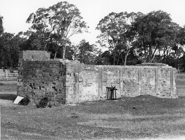
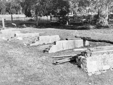
Photograph, Brick remains of the Tannery of Mr C Whel off Halls Gap Road Stawell West behind the London Hotel 1982
... Road Stawell West behind the London Hotel 1982...Brick remains of Tannery run by C Whel off Halls Gap Road... grampians Brick remains of Tannery run by C Whel off Halls Gap Road ...Brick remains of Tannery run by C Whel off Halls Gap Road Stawell West behind the London Hotel 1982stawell industry -
 Stawell Historical Society Inc
Photograph, Brick remains of the Tannery of Mr C Whel off Halls Gap Road Stawell West behind the London Hotel 1982
... Road Stawell West behind the London Hotel 1982...Brick remains of Tannery run by C Whel off Halls Gap Road... grampians Brick remains of Tannery run by C Whel off Halls Gap Road ...Brick remains of Tannery run by C Whel off Halls Gap Road Stawell West behind the London Hotel 1982stawell industry -
 Greensborough Historical Society
Map, Dianne Edwards, Part of Parish of Yan Yean 1878, 1978
... , roads and various other features west of Greensborough Road... west of Greensborough Road. Redrawn by A. R. Blair in 1978. yan ...Map includes Crown Portions V - XVII, showing Yan Yean Reservoir, Melbourne-Whittlesea Railway route, names of landowners, roads and various other features west of Greensborough Road. Redrawn by A. R. Blair in 1978.1 p. black and white photocopy of mapyan yean reservoir, yan yean -
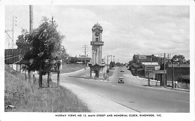 Ringwood and District Historical Society
Photograph/Postcard, Postcard and souvenir photograph - Murray Views No.12. Main Street and Memorial Clock, Ringwood, Vic
... photograph - Ringwood Memorial Clocktower, looking west from cnr..., looking west from cnr. Warrandyte Road and Maroondah Highway ...Black and white "Murray Views" postcard and souvenir photograph - Ringwood Memorial Clocktower, looking west from cnr. Warrandyte Road and Maroondah Highway, Ringwood, Vic. Circa late 1940s.Printed on back - Post Card - Real Photographs produced in Australia by Murray Views, Gympie, Q. Handwritten - "1949 or 48". -
Glenelg Shire Council Cultural Collection
Photograph - Photograph - oil tanks, n.d
... Black and white photograph showing shell oil tanks, west... shell oil tanks, west side of Wellington Road. Photo taken from ...Port of Portland Authority ArchivesBack: 2398 Lines drawn in biro 5 3/4" 4 1/8" 8036 s/s in pencilport of portland archives, shell oil, portland, fishermans breakwater, satcol