Showing 103 items
matching whittlesea shire
-
 City of Whittlesea
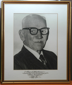
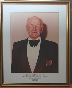
Photograph (item) - Photographs - Councillors, Councillor TH Hurrey MBE JP Shire President 1939 – 1945 & 1953 - 1954
whittlesea councillors, whittlesea council -
 City of Whittlesea
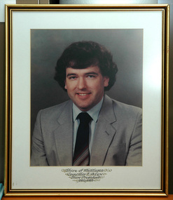
Photograph (item) - Photographs - Councillors, Councillor L.A.Cox Shire President 1982 - 1983
subjects whittlesea councillors, whittlesea council -
 City of Whittlesea
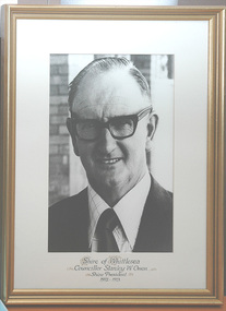
Photograph (item) - Photographs - Councillors, Councillor Stanley W Owen Shire President 1972 - 1973
whittlesea councillors, whittlesea council -
 City of Whittlesea
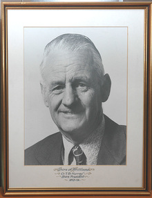
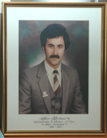
Photograph (item) - Photographs - Councillors, Councillor T.B. Hurrey Shire President 1973-74
whittlesea councillors, whittlesea council -
 City of Whittlesea
Photograph (item) - Photographs - Councillors, Councillor G.E. Draper, JP Shire President 1966 - 1967/1975-1976
whittlesea councillors, whittlesea council -
 City of Whittlesea
Photograph (item) - Photographs - Councillors, Councillor F.Merlino JP Shire President 1986 - 1987
whittlesea councillors, whittlesea council -
 City of Whittlesea
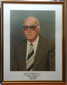
Photograph (item) - Photographs - Councillors, Councillor H.R Uren JP Shire President 1961 - 1963/1974 - 1975
whittlesea councillors, whittlesea council -
 Eltham District Historical Society Inc
Photograph - Digital Photograph, Alan King, Nillumbik Shire Offices, Greensborough, 30 March 2008
Nillumbik Shire Council transferred to the former Diamond Valley Shire Offices in Greensborough after municipal restructuing. The offices became the official Nillumbik Shire Council Offices on 16 October 1995. The former Shire of Diamond Valley Civic Centre or Shire Office building was officially opened on 26th February 1972. Archtiects were A.K. Lines, McFarlane & Marshall and it was built by L.U. Simon Pty Ltd, The Diamond Valley Shire had been created in 1964 from part of the City of Heidelberg. On December 15, 1994 the Shire of Nillumbik was established. Under the Council amalgamations imposed by the Kennett government, the Shire of Eltham, Shire of Diamond Valley and City of Heidelberg ceased to exist with the establishment of Nillumbik Shire Council and the City of Banyule.The new Nillumbik shire surrended the west riding from Eltham to Banyule but in place gained parts of the former Diamond Valley Shire which itself had been created in 1964 from parts of the City of Heidelberg. Three unelected and non-local Commissioners were put in place by the government bringing democracy into question by many members of the local community. The Commissioners determined to abandon the former Shire of Eltham offices located in Main Road, Eltham and in turn occupy the former Shire of Diamond Valley offices located at the boundary of the new shire with Banyule, in Civic Drive, Greensborough. In July 1996 the Commissioners sold the former Eltham Shire Offices and had them bulldozed leading to many years of communiity protest over the process and future development applications. The site has remained vacant ever since. Published: Nillumbik Now and Then / Marguerite Marshall 2008; photographs Alan King with Marguerite Marshall.; p43 It was the need for roads that led to this district’s first council. In 1853 a committee was formed to improve the rough roads, some in Kangaroo Ground being almost impassable in winter.1 The committee fundraised by voluntary levies and grants to improve in particular, the main road between Kangaroo Ground and the Plenty River. From this committee arose the Eltham District Road Board, in 1856, which was the precursor to the Eltham Shire Council. The Board’s first chairman was Kangaroo Ground farmer, John Barr. Secretary was the former committee’s secretary, Andrew Ross, Kangaroo Ground’s first school teacher, and founder of the district newspaper, The Evelyn Observer.2 Most of the board’s income came from a toll-house north of the Lower Plenty Bridge, which funded such projects as a road from Kangaroo Ground to the Caledonia Diggings. In 1871 the Shire of Eltham was proclaimed, with its boundaries the same as those of the Road Board, and Councillor A Donaldson of Kangaroo Ground was the first president. Eltham was at the southern tip of the shire, which extended north to Kinglake and east beyond Yarra Glen. In 1878, part of Kinglake was added to the shire, while the area east of Watts River, near Healesville was removed. In 1912, then again in 1958, the shire was further reduced. Yarra Glen, Steels Creek, Tarrawarra, parts of Healesville and Christmas Hills, were transferred to the Shire of Healesville. In 1972 a smaller area, at Kinglake, was transferred to the Shire of Yea, leaving 277 square kilometres in the Eltham Shire. Perhaps no other Victorian municipality has had so many meeting places. Although from 1858 to 1904, the council convened at the office in the home of Secretary Charles Wingrove, the board, and later the council, also met at other more central locations.3 The board moved from the Fountain of Friendship Hotel to the Eltham Courthouse, to the Kangaroo Ground schoolhouse. It then met at the Kangaroo Ground Hotel, which some considered put it in danger of interruptions by people ‘the worse for liquor’.4 In 1885 the council met at the hall on Mr J Donaldson’s land at Kangaroo Ground. After Wingrove’s retirement, the council rented space at the Kangaroo Ground General Store and Post Office. Then, in 1917, the council bought the former office of The Evelyn Observer, after its printing works transferred to Hurstbridge. In 1934, fire destroyed the shire office, which was temporarily relocated to the Kangaroo Ground home of Shire Secretary, Mr P J McMahon. In 1941, the shire office moved to a new building (which included a public hall) in Eltham, at the corner of Arthur Street and Main Road, where the Eltham Village Shopping Centre was eventually built. Growth required new offices, which opened in 1965, on the former Shillinglaw property in Main Road.5 In 1994, as part of municipal restructuring under the Jeff Kennett Liberal Government, most of the Eltham Shire formed part of the new Shire of Nillumbik. It joined with the north section of the Diamond Valley Shire and parts of the Healesville and Whittlesea municipalities. The Diamond Valley Shire had been created in 1964, from part of the City of Heidelberg. Turbulence followed Nillumbik Shire’s formation. Under the Commissioners the council transferred to the former Diamond Valley Shire offices in Greensborough, and the Eltham council offices were demolished. In March 1997 the first five-member Nillumbik Council was elected. But, in October 1998, the government suspended the council and appointed an administrator . Early in 1999, shire residents voted to increase councillors to nine: comprising five ward councillors and four shire-wide councillors. Elections were held in March 1999. Then, before the March 2002 elections, nine new wards were created.6 In 2008 these were reduced to seven. Today [2008] the council governs a varied population of more than 60,000 people living in townships and on bush properties in the green wedge.This collection of almost 130 photos about places and people within the Shire of Nillumbik, an urban and rural municipality in Melbourne's north, contributes to an understanding of the history of the Shire. Published in 2008 immediately prior to the Black Saturday bushfires of February 7, 2009, it documents sites that were impacted, and in some cases destroyed by the fires. It includes photographs taken especially for the publication, creating a unique time capsule representing the Shire in the early 21st century. It remains the most recent comprehenesive publication devoted to the Shire's history connecting local residents to the past. nillumbik now and then (marshall-king) collection, greensborough, nillumbik shire council offices, civic drive -
 Eltham District Historical Society Inc
Photograph - Digital Photograph, Alan King, Monash Bridge, Hurstbridge, 23 January 2008
Monash Bridge spans the Diamond Creek at Hurstbridge. It was built in 1917 for the Shires of Heidelberg, Eltham and Whittlesea. It is considered Nillumbik Shire's finest engineered bridge and was construced by the engineering company of Sir John Monash. Covered under Heritage Overlay, Nillumbik Planning Scheme. Published: Nillumbik Now and Then / Marguerite Marshall 2008; photographs Alan King with Marguerite Marshall.; p117 Monash Bridge is considered the Shire’s finest engineered bridge and was constructed by the engineering company of that great Australian, Sir John Monash.1 The bridge spans Diamond Creek on the Hurstbridge-Arthurs Creek Road, linking Hurstbridge with Yarrambat and Arthurs Creek. Monash Bridge, also called Hurst’s Bridge, was built in 1917, by the Reinforced Concrete and Monier Pipe Construction Company Pty Ltd, for the Shires of Heidelberg, Eltham and Whittlesea. Although Monash was probably in action overseas during World War One when the bridge was designed and constructed, he evolved the basic design in the 1900s and it was a standard design for the firm. However J A Laing, a designer at the firm, was probably the designer, as his initials are on bridge drawings held by the Eltham District Historical Society.2 The bridge is an excellent early Australian example of an open spandrel reinforced concrete arch bridge and has a single span of 29 metres. It is unusual in Victoria, but similar to many reinforced concrete arch bridges in Europe and America, built from the late 19th century. In Victoria, Monash pioneered the use of reinforced concrete – then a revolutionary construction material. His company, Monash & Anderson, had the exclusive licence for the Monier patent for the system of reinforced concrete construction for Victoria and New South Wales. A well-known example of the Monier arch bridge is the Morell Bridge in South Yarra. The sweeping arch of the Monash Bridge combines grace and utility and blends with the surrounding rural landscape. Its design and construction have allowed it to carry increasing volumes of heavy traffic, but in modern times the one lane is considered by some to prevent easy passage through Hurstbridge. However others consider this an asset to deter too much more traffic, which would diminish Hurstbridge’s charming rural character.3 This is the third bridge across the Diamond Creek at this site. The original bridge was a log bridge upstream, constructed in the 1850s by early settler, Henry Hurst, after whom Hurstbridge was named. The bridge spanned the creek, where it divided his family’s property. In the 1880s a timber bridge replaced it, known as Hurst’s Bridge. However a more permanent bridge was considered necessary when the new railway arrived in 1912, bringing with it expectations of growth in the town and the surrounding fruit-growing district. Monash Bridge’s official opening on November 3, 1917 was a gala occasion, which took place before about 1000 spectators. Two who attended the opening had a particularly sound knowledge of the locality. One was Fred Hurst, Henry’s brother, who used to ford the creek at or near the bridge’s site more than 50 years before. The other was John McDonald of Arthurs Creek, who had built the old wooden bridge over the creek about 40 years earlier.4 Although John Monash was a fine engineer, his fame came from his brilliant war career, rather than from his engineering or his many other achievements. Monash was Corps Commander of the Australian Forces. His brilliance was recognised with his awards: Knight Grand Cross of the Order of St. Michael and St. George, and Knight Commander of the Bath. Monash was also decorated by the French, Belgian, and American Governments.5 After the war, Monash worked in many prominent civilian positions, the most notable as head of the Victorian State Electricity Commission. He was a leading and loved public figure, involved in many public and private organisations. He was president of the Australian Zionist Federation and involved in the Boy Scouts. Monash University is named after him. By the 1920s Monash was probably regarded as the greatest living Australian.6 Despite most of his life working as an administrator and leader, rather than a fighting soldier, he became integral to the ANZAC legend. Monash died in 1931.This collection of almost 130 photos about places and people within the Shire of Nillumbik, an urban and rural municipality in Melbourne's north, contributes to an understanding of the history of the Shire. Published in 2008 immediately prior to the Black Saturday bushfires of February 7, 2009, it documents sites that were impacted, and in some cases destroyed by the fires. It includes photographs taken especially for the publication, creating a unique time capsule representing the Shire in the early 21st century. It remains the most recent comprehenesive publication devoted to the Shire's history connecting local residents to the past. nillumbik now and then (marshall-king) collection, hurstbridge, monash bridge -
 Eltham District Historical Society Inc
Photograph - Digital Photograph, Marguerite Marshall, Stuchbery Farm dairy, 14 March 2008
Stuchbery Farm was situated on the Plenty River bounded by Smugglers Gully to the north and La trobe Road, Yarrambat, to the east. Alan and Ada Stutchbery moved to the valley in 1890, first living in a tent where four children were born. Alfred built a home and outbuildings around 1896. They planted an orchard, then a market garden and developed a dairy. Published: Nillumbik Now and Then / Marguerite Marshall 2008; photographs Alan King with Marguerite Marshall.; p179 The dramatic steep-sided Plenty Gorge lies along the divide of two geological areas, and separates the Nillumbik Shire and the City of Whittlesea. On the Nillumbik side are undulating hills and sedimentary rock, and in Whittlesea, lies a basalt plain formed by volcanic action up to two million years ago. This provides the Plenty Gorge Park with diverse vegetation and habitats, making it one of Greater Melbourne’s most important refuges for threatened and significant species. The park, established in 1986, consists of around 1350 hectares, and extends 11 kilometres along the Plenty River, from Greensborough to Mernda. It provides a wildlife corridor for around 500 native plant and 280 animal species.1 The area’s plentiful food and water attracted the Wurundjeri Aboriginal people and then European settlers. By 1837 squatters had claimed large runs of land for their sheep and cattle. The Plenty Valley was among the first in the Port Phillip District to be settled - mainly in the less heavily timbered west - and was proclaimed a settled district in 1841.2 But by the late 1880s, the settlers’ extensive land clearing for animal grazing, then agriculture, depleted the Wurundjeri’s traditional food sources, which helped to drive them away. Many Wurundjeri artefacts remain (now government protected), and so far 57 sites have been identified in the park, including scarred trees, burial areas and stone artefacts. Pioneer life could be very hard because of isolation, flooding, bushfires and bushrangers. Following the Black Thursday bushfires of 1851, basalt was quarried to build more fire-resistant homes. Gold discoveries in the early 1850s swelled the population, particularly around Smugglers Gully; but food production made more of an impact. In the late 1850s wheat production supplanted grazing. In the 1860s the government made small holdings available to poorer settlers. These had the greatest effect on the district, particularly in Doreen and Yarrambat, where orchards were established from the 1880s to 1914. Links with a prominent early family are the remains of Stuchbery Farm, by the river’s edge bounded by Smugglers Gully to the north and La Trobe Road, Yarrambat, to the east. The Stuchberys moved to the valley in 1890, and the family still lives in the area. In 1890, Alfred and Ada first lived in a tent where four children were born, then Alfred built the house and outbuildings around 1896. They planted an orchard, then a market garden, and developed a dairy. The family belonged to the local Methodist and tennis communities. Their grandson Walter, opened the Flying Scotsman Model Railway Museum in Yarrambat, which his widow, Vi, continues to run. Wal was also the Yarrambat CFA Captain for 22 years until 1987. Walter sold 24 hectares in 1976 for development - now Vista Court - and in 1990, the remaining 22.6 hectares for the park. Remaining are an early stone dairy and remnants of a stone barn, a pig sty and a well.3 Until it was destroyed by fire in 2003, a slab hut stood on the Happy Hollow Farm site, at the southern end of the park. The hut is thought to have been built in the Depression around 1893. This was a rare and late example of a slab hut with a domestic orchard close to Melbourne. Emmet Watmough and his family first occupied the hut, followed by a succession of families, until the Bell family bought it around 1948. There they led a subsistence lifestyle for 50 years, despite encroaching Melbourne suburbia.4 The Yellow Gum Recreation Area includes the Blue Lake, coloured turquoise at certain times of the year. Following the 1957 bushfires, this area was quarried by Reid Quarries Pty Ltd for Melbourne’s first skyscrapers, then by Boral Australia. However in the early 1970s water began seeping into the quarry forming the Blue Lake and the quarry was closed. The State Government bought the site in 1997 and opened it as a park in 1999.This collection of almost 130 photos about places and people within the Shire of Nillumbik, an urban and rural municipality in Melbourne's north, contributes to an understanding of the history of the Shire. Published in 2008 immediately prior to the Black Saturday bushfires of February 7, 2009, it documents sites that were impacted, and in some cases destroyed by the fires. It includes photographs taken especially for the publication, creating a unique time capsule representing the Shire in the early 21st century. It remains the most recent comprehenesive publication devoted to the Shire's history connecting local residents to the past. nillumbik now and then (marshall-king) collection, ada stuchbery, alan stuchbery, dairy, stuchbery farm, farm buildings, yarrambat, plenty gorge park -
 Eltham District Historical Society Inc
Photograph - Digital Photograph, Alan King, Blue Lake, Plenty Gorge Park, 2008
A quarry was transformed into the Blue Lake. Published: Nillumbik Now and Then / Marguerite Marshall 2008; photographs Alan King with Marguerite Marshall.; p179 The dramatic steep-sided Plenty Gorge lies along the divide of two geological areas, and separates the Nillumbik Shire and the City of Whittlesea. On the Nillumbik side are undulating hills and sedimentary rock, and in Whittlesea, lies a basalt plain formed by volcanic action up to two million years ago. This provides the Plenty Gorge Park with diverse vegetation and habitats, making it one of Greater Melbourne’s most important refuges for threatened and significant species. The park, established in 1986, consists of around 1350 hectares, and extends 11 kilometres along the Plenty River, from Greensborough to Mernda. It provides a wildlife corridor for around 500 native plant and 280 animal species.1 The area’s plentiful food and water attracted the Wurundjeri Aboriginal people and then European settlers. By 1837 squatters had claimed large runs of land for their sheep and cattle. The Plenty Valley was among the first in the Port Phillip District to be settled - mainly in the less heavily timbered west - and was proclaimed a settled district in 1841.2 But by the late 1880s, the settlers’ extensive land clearing for animal grazing, then agriculture, depleted the Wurundjeri’s traditional food sources, which helped to drive them away. Many Wurundjeri artefacts remain (now government protected), and so far 57 sites have been identified in the park, including scarred trees, burial areas and stone artefacts. Pioneer life could be very hard because of isolation, flooding, bushfires and bushrangers. Following the Black Thursday bushfires of 1851, basalt was quarried to build more fire-resistant homes. Gold discoveries in the early 1850s swelled the population, particularly around Smugglers Gully; but food production made more of an impact. In the late 1850s wheat production supplanted grazing. In the 1860s the government made small holdings available to poorer settlers. These had the greatest effect on the district, particularly in Doreen and Yarrambat, where orchards were established from the 1880s to 1914. Links with a prominent early family are the remains of Stuchbery Farm, by the river’s edge bounded by Smugglers Gully to the north and La Trobe Road, Yarrambat, to the east. The Stuchberys moved to the valley in 1890, and the family still lives in the area. In 1890, Alfred and Ada first lived in a tent where four children were born, then Alfred built the house and outbuildings around 1896. They planted an orchard, then a market garden, and developed a dairy. The family belonged to the local Methodist and tennis communities. Their grandson Walter, opened the Flying Scotsman Model Railway Museum in Yarrambat, which his widow, Vi, continues to run. Wal was also the Yarrambat CFA Captain for 22 years until 1987. Walter sold 24 hectares in 1976 for development - now Vista Court - and in 1990, the remaining 22.6 hectares for the park. Remaining are an early stone dairy and remnants of a stone barn, a pig sty and a well.3 Until it was destroyed by fire in 2003, a slab hut stood on the Happy Hollow Farm site, at the southern end of the park. The hut is thought to have been built in the Depression around 1893. This was a rare and late example of a slab hut with a domestic orchard close to Melbourne. Emmet Watmough and his family first occupied the hut, followed by a succession of families, until the Bell family bought it around 1948. There they led a subsistence lifestyle for 50 years, despite encroaching Melbourne suburbia.4 The Yellow Gum Recreation Area includes the Blue Lake, coloured turquoise at certain times of the year. Following the 1957 bushfires, this area was quarried by Reid Quarries Pty Ltd for Melbourne’s first skyscrapers, then by Boral Australia. However in the early 1970s water began seeping into the quarry forming the Blue Lake and the quarry was closed. The State Government bought the site in 1997 and opened it as a park in 1999.This collection of almost 130 photos about places and people within the Shire of Nillumbik, an urban and rural municipality in Melbourne's north, contributes to an understanding of the history of the Shire. Published in 2008 immediately prior to the Black Saturday bushfires of February 7, 2009, it documents sites that were impacted, and in some cases destroyed by the fires. It includes photographs taken especially for the publication, creating a unique time capsule representing the Shire in the early 21st century. It remains the most recent comprehenesive publication devoted to the Shire's history connecting local residents to the past. nillumbik now and then (marshall-king) collection, blue lake, plenty gorge park -
 Eltham District Historical Society Inc
Photograph - Digital Photograph, Alan King, Kinglake National Park, 27 March 2008
Fern gullies around Jehosaphat Gully Covered under National Estate. Published: Nillumbik Now and Then / Marguerite Marshall 2008; photographs Alan King with Marguerite Marshall.; p125 The magnificent Kinglake National Park, fringing Nillumbik’s north, is the largest national park close to Melbourne. Thanks to the vision and hard work of a band of local people, the park was created from what was rapidly becoming degraded land. Seeing a threat to Kinglake’s indigenous flora and fauna, several prominent local people campaigned for a national park, which was established in 1928.1 Since then, the park has grown through donations and acquisitions of land, from around 13,800 acres of land (5585ha) to 22,360 hectares. The Sugarloaf and Everard Blocks – of almost 8000 hectares – stand in Nillumbik and the park extends into Mitchell and Murrundindi Shires and the City of Whittlesea. Mt Everard commemorates William Hugh Everard, State member for Evelyn when the park was established. Before 1928, European settlers had degraded the Kinglake area, which was named after the celebrated English author and lawyer, Alexander William Kinglake. Remains of gold shafts and diggings in the park are reminders of Kinglake’s first settlers, who hoped to strike it rich at the gold diggings. But like other gold fields in this shire, they proved not very lucrative and soon timber cutting replaced mining in importance. However, before long, the accessible timber supply ran out, so in the 1920s agriculture took over – particularly potatoes and berry fruits – which involved large-scale clearing.2 The park’s instigator was retired Melbourne University Professor of Music, William Laver.3 As chair of the Kinglake Progress Association he began negotiations to have crown lands on the southern scarp of the Great Dividing Range reserved as a national park. Even before the park was proclaimed, from 1927, KPA members cut tracks to the major scenic points. Professor Laver was one of several people who gave land for the park, donating around 50 acres (20ha), including the Jehosaphat Gully.4 Laver chaired the park’s first Committee of Management, which raised money to employ a ranger and provide facilities, including tracks and roads for fire protection vehicles, toilets and shelters. The committee charged fees for firewood collection, some grazing of livestock, and visitor entrance, and obtained small State Government and Eltham Shire grants. In 1957 the State Government provided revenue for national parks. Then, in 1975, the State Government took over the management and the Committee of Management became an advisory committee, which disbanded in 1978. Originally, the park covered crown land in the Shires of Eltham and Whittlesea; then Wombelano Falls in Yea and other areas were added. In 1970 the park extended into the Shires of Eltham, Healesville, Whittlesea and Yea.5 Bush fires have been an ongoing problem. In 1939 hundreds of eucalypts and acacias had to be sown around the Jehosaphat Gully to rejuvenate the forest. To manage bushfires, the Committee of Management, then the State Government, worked closely with the Forestry Commission, shire councils and local fire brigades. Early national parks focussed on recreation. But by the 1980s, conservation, education and scientific research became more important, playing a vital role in preserving representative samples of the natural environment. Each year many thousands of people use the park’s extensive network of walking tracks amongst the protected plant and animal life as well as camping, cycling and horse riding. The park, along the slopes of the Great Dividing Range, has lookouts revealing magnificent views of the Melbourne skyline, Port Phillip Bay, the Yarra Valley and the You Yangs. Vegetation in the Masons Falls area includes messmate forest, Austral grass-trees, ferns and Hazel Pomaderris. In spring, orchids, lilies, everlasting daisies, correas, grevillea and heath appear. Around Jehosaphat Gully are wet and dry forest, fern gullies and banksia. Animal life includes wallabies, kangaroos, koalas, echidnas, possums, gliders and bandicoots. Male lyrebirds can be heard mimicking in the Jehosaphat Gully, particularly in the Everard Block in winter.This collection of almost 130 photos about places and people within the Shire of Nillumbik, an urban and rural municipality in Melbourne's north, contributes to an understanding of the history of the Shire. Published in 2008 immediately prior to the Black Saturday bushfires of February 7, 2009, it documents sites that were impacted, and in some cases destroyed by the fires. It includes photographs taken especially for the publication, creating a unique time capsule representing the Shire in the early 21st century. It remains the most recent comprehenesive publication devoted to the Shire's history connecting local residents to the past. nillumbik now and then (marshall-king) collection, kinglake national park, jehosaphat gully -
 Eltham District Historical Society Inc
Archive Box, Shire of Eltham War Memorial
Material relating to the Shire of Eltham War Memorial located at Garden Hill, Kangaroo Ground. Also known as The Eltham Shire War Memorial Tower, Shire of Eltham Soldiers' Memorial and Kangaroo Ground War Memorial Park. Includes photocopies, newspaper clippings, correspondence and more beginning from early history 1919-2009. Contents: Archive Box 1 Folder 1 (Publication Proofs) The Tower of Remembrance and War Memorial Park On Garden Hill at Kangaroo Ground, Victoria 1919-2010 Folder 2 (Up to 1960) 1. Binder with plastic pockets. Photocopies. Minutes of the Kangaroo Ground War Memorial Bazaar Committee, 1922-1926 EDHS Newsletter No. 123 November 1998 PRESIDENT'S REPORT ACQUISITION FROM NILLUMBIK SHIRE'S MEMORABILIA Recently found in a storage box of old Shire of Eltham items was a school size, blue lined black covered writing book. It is recognized as the minute book and cash receipt book of the period 1922-1926 when the Memorial Park Committee, who it seems were part of the Shire of Eltham Soldier's Memorial League, was requested to raise funds for building the Shire of Eltham War Memorial Tower at Kangaroo Ground. History tells us that the tower, which is currently being refurbished, was officially opened by the Governor General of Australia, Lord Stonehaven on 11.11.26. The ladies invited to the first meeting at the Shire Hall did so on 21st September 1922. The minutes book reads: Present: Mesdames Bell, Bourchier, McMahon, Gosling, Cockcroft, Wraight, E Coutie, R Rogers, A Jones, AH White, Davies, Everitt and the Misses Lacey, Harris, N Weller, Gosling, Bell and D and G J Bourchier. These people became the Kangaroo Ground Memorial Bazaar Committee along with others named at further meetings. They conditionally accepted the role of raising funds, their condition being that the Bazaar Committee be given representation on any committee empowered to deal with the memorial in proportion to the amount of money raised by the bazaar'. The Andrew Ross Museum has the original book. We at Eltham District Historical Society have two photocopies for public perusal. 2. Transcriptions of newspaper articles 1919-1920. 6 pages. 3. Photocopy of program for thanksgiving service July 6th, 1919 held at Public Hall, Panton Hill. 4. Photocopies: a. Kangaroo Ground, The Advertiser, 17 Oct 1919 (working bee) b. The Advertiser August 1920 – advertisement for coach between Eltham and KG. c. Anzac Memorial Service, The Eltham & Whittlesea Shires Advertiser & Diamond Creek Advertiser, April 14, 1922 and April 28, 1922 d. Anzac Day services. April 27, 1923 e. Photocopy Anzac Commemoration, local newspaper, May 2, 1924 f. Shire of Eltham Memorial Service, The Advertiser April 23, 1926 g. Eltham Shire War Memorial Advertiser August 13,1926 h. Eltham Shire War Memorial The Advertiser October 26, 1926 i. Eltham The Advertiser, December 17, 1926 j. Kangaroo Ground April 26, 1929 5. Photocopy. Eltham War Memorial Tower article, The Advertiser, November 19, 1926 6. Typed transcription of parts of newspaper articles for three titles, November 1926 7. Transcription. Public Notice, October 16, 1926 8. Photocopy Kangaroo Ground Armistice Day local newspaper, November 25, 1927 9. Photocopy Kangaroo Ground Armistice Day local newspaper, November 16, 1928 10. Photocopy Kangaroo Ground, local newspaper, April 26 1929 11. 3 Original Copies. One Hardback. Dedication of memorial official brochure, 1951 original but damaged 12. Photocopy with notes from G.G. relating to the land transfer/acquisition/contract via White and Gepp. Folder 3 (1961-1970) 1. Original newspaper article: Place with a view at Kangaroo Ground, The Age, May 11, 1963, p18 Folder 4 (1981-1990) 1. Newspaper article, Memorial a fire watch. Diamond Valley News, March 16, 1982, 2 original copies. 2. Newspaper article. An Obvious Monument by Russell Yeoman article with photo: Network Nov/Dec 1984, p14. Folder 5 (1991-2000) 1. Original newspaper article: “Kangaroo Ground Tower is top spot”. Thought to be from a tourist information free newspaper, Mountain Country, Summer [1993] p39. 2. Newspaper article with reference to quoins – a contrasting edging or corner stone on the façade of a stone or brick house. Age August 2000 3. Program. Service program for Remembrance Day commemoration ceremony, 1996. 4. Speech by Harry Gilham for Remembrance Day commemoration ceremony, 1996 5. Newspaper article: Remembrance, Diamond Valley News, 20 November 1996 6. Word Document. A Tower of Strength by Dean Stewart April 1997 7. Newspaper articles: Tower group needed, Diamond Valley News, September 17, 1997, p3 and advertisement “Nillumbik, Nominations for Kangaroo Ground Memorial Tower and Grounds Advisory Committee”, Diamond Valley News, September 17, 1997 8. Newspaper article: Council apology; scaling new heights, 1997 about Aboriginal Reconciliation. Probably Diamond Valley News ca 1997. 9. Photocopy / Newspaper Article: Two newspaper clippings, “Memorial with a view” 30 April 1997 and “Funds boost to restore tower to its former glory”, Diamond Valley News, 3 December 1997. 10. Newspaper article: Kangaroo Ground Tower of Remembrance Nillumbik Mail, 9th August 2000 and Research notes (July 2000) by Harry Gilham pertaining to photo in August 2000 newspaper article. 11. Photocopy. Newspaper article: New lease of life for tower (Concept plan) Nillumbik Mail, September 27, 2000 12. Photocopy: 4 pages, War Memorials of Victoria; a pictorial record, c.1994 Folder 6 (2001-2010) 1. Newspaper article: $10,000 to start refurbishment, Nillumbik Mail, Feb 21, 2001 2. Circular. KG War Memorial Advisory committee circular August 2001 3. Newspaper article: Tower group retained 4. Program for re-dedication of the Kangaroo Ground War Memorial Tower 8th November 2001 with copies of pages 65-70 of from The Tower of Remembrance and War Memorial Park 1919-2001 (see Folder 1) - Speaking notes from the day from Nillumbik Shire Mayor, Cr. Sigmund Jorgensen and Harry Gilham and Speech by John Landy, Governor of Victoria 5. 2 pages of Harry Gilham notes – Draft of ‘book’ notes ‘Thank you’ for rededication ceremony to be held Thursday, Nov 8, 2001 - list of invitations, notifications and acknowledgements. 6. Proposed running sheet. Re-dedication of KGT. November 8, 2001 7. Newspaper article (2 copies) Century of war service, DVL November 14, 2001 page 6 8. Letter. Gov. John Landy to Harry Gilham. Thank you for visit. [2001] 9. Newsletter Clipping: Governor of Victoria re-dedicates KG War memorial Tower, Nillumbik News (NSC) Christmas 2001 10. Newspaper article: War Memorial to be restored: DVL November 19, 2003 11. Newspaper article: Memorial Facelift Sept 29 2004. 12. Folder. Collection of maps and context Yarra Water proposal to build water tanks 13. Newspaper clipping. Pressure on with new tank. Re installation of water tank near site. DVL March 2, 2005 14. Folder of emails and designs from Dennis Ward re poppies and prostrate rosemary for formal garden around base of tower April 2005 15. Folder. Letters and paperwork re the Victorian Government “Community Cabinet” and invitation for community groups to speak directly with a government minister. Actual submission not included in folder. 16. Newspaper clipping. Time to remember among the poppies, Diamond Valley Leader, 9 November 2005, p1 and 17. Newspaper clipping. Lone pine company for souls. DVL 9 November 2005 18. Folder. Restoring Community War Memorials Grants Program. Application and associated paperwork 2005/2006 January 2006 19. Newspaper article. Shared views. Valley Weekly, June 21 2006 20. Newspaper article: Kangaroo Ground, Restoration on schedule, DVL October 2006? 21. Newspaper article. Towering over the terrain. The Age August 8, 2009 22. Photocopy. Nillumbik Shire Council. Policy and service report re lease of land to Victoria Police for police radio communications and re-building of radio tower. December 9, 2009 23. Schematics: A3 photocopies, Kangaroo Ground memorial Tower, front and rear view, Tom Manley, 17 Apr 2001 Folder 7 (2011 on) 1. Magazine article and cover. Cover story – The Kangaroo Ground Memorial Tower, The Genealogist, March 2010 2. Newspaper article. (2 copies) Photo and caption. Diamond Valley Leader, July 14, 2010 3. Newspaper notice: Notice of application for a planning permit to construct radio communications tower, DVL, October 10, 2012 4. Copy. Reference enquiry to National Film and Sound Archive. 10 September 2012 5. Copy letter. Quotation/estimate for Shire of Nillumbik on renovation and underpinning of old care takers cottage, KG. 30 September, 2012 6. Story. The Kangaroo Ground Tower of Remembrance by Amy Shaw. Yarrambat Primary School Year 6 History speech, 2014. 7. Program: Remembrance Day service, 11th November 2014 8. Newspaper article. Tribute to bravery DVL, November 19, 2014. 9. Minutes. MAC meeting. 2 September 2016. Folder 8 (Interpretative Signs Grant 2000-2001) 1. Folder. Various including Letters. EDHS Grant project: Kangaroo Ground Park and Tower of Remembrance interpretative signage from Parks Victoria 2000-2001. Folder 9 (Miscellaneous) 1. Folder Gilham collection. Google earth images of Tower, Extract describing history of Tower, including honour roll for WW1 and WW2, 8 pages, Extract describing history of Tower, including honour roll for WW1 and WW2, 3 pages, 2002 and 2004; Kangaroo Ground Tower; Southwell-Keely M.; WAR MEMORIALS IN AUSTRALIA; 8 pages, https://web.archive.org/web/20080722161554/http://www.skp.com.au/memorials2/pages/30054.htm) 2. Letter. Undated, unsigned re application to council to proposed work to police radio masts behind caretaker’s cottage. 3. Brochure: Heritage Nillumbik. Includes cover photo and other information about site. Published by Nillumbik Shire Council. About 2006. 4. Folder of notes and photocopies of various Certificates of Title for property 5. Inward loan documents. Two. Andrew Ross Museum inward loan for collection items from “War Memorial Tower” 2003 6. Photocopies of postcards of Soldiers War Memorial: One taken c.1926 before completion around base, on colour print on paper (enlarged) of Soldiers War Memorial postcard c.1930s prior to gun placements with typed text pasted on and additional detail version mounted on card with handwritten explanatory notes by Harry Gilham. 7. Photocopy of photo of tower 1944 with guns in place from Gordon and explanatory notes plus A4 photo paper print of image (photoshopped cleaned up). 8. Miscellaneous photocopies of photos taken by Harry Gilham of Memorial Park entrance, model tower in font of tower entrance, caretaker’s cottage, spiral staircase, Menin Gate sign and possibly planting of Lone Pine. Folder 10 (Fire Spotting Operations) 1. Biographical notes on Herman Motschall 1969-1981 2. Newspaper article, Memorial Tower top site for fire spotter, Diamond Valley News, May 15, 1973. 3. Proper Officer's report on an addition to the Kangaroo Ground Memorial Tower for Fire Spotting purposes: "This report covers the history of the tower, its uses, and reasons why it should be put to greater use, benefiting the Shire Council and ratepayers" Includes detailed commentary around the proposal to use the Shire of Eltham War Memorial at Kangaroo Ground for fire spotting. From Shire of Eltham archives. H. J. Masefield Property Officer. 4. Eltham Shire Council meetings 14 and 24 September 1973 references to fire watching facilities. Summary of end of season reports from spotters 1965-1973. 5. Newspaper clipping; Memorial a fire watch by Marguerite Marshall Diamond Valley News 16 March 1982 6. Letter: Cover letter from Dennis Ward 20 Feb 2006 architect for CFA Cabin design and Proposal to upgrade the fire spotting cabin, 2007 including a cost and concept plan dated 7 February 2009. 7. Newspaper article. From that first puff of smoke – horror. Diamond Valley Leader, Feb 25, 2009, p. 7 8. Invitation: State Government announcement of refurbishment of KGWM Fire spotting tower 19 October 2009 9. Newspaper article. Tower– up, Black Saturday watch. Cover and page. Diamond Valley Leader, October 28, 2009 10. Invitation. Opening of newly upgraded fire spotting tower, 11 April 2010 11. Newspaper article. Incredible luxury at fire spotting tower, Diamond Valley Leader, April 21, 2010, p, 5 12. Printout of plan of base of tower including comms cabinet and ladder to CFA cabin. Dated 17/6/2010 Archive Box 2 Folder 11 (Moor-rul Viewing Platform) 1. Agenda. Planning and building committee 12 March 2003 Application for construction of a viewing platform and road entry refurbishment and coach parking bay. 2. Envelope. Letters, paperwork and emails, mainly from Dennis Ward re roof design for the viewing platform and order for poppy seeds. 2005 3. Newspaper article (enlarged and laminated). Stolen Red gum seats sap new project’s momentum. (Local paper), April 3, 2007 4. Convenor’s Notes – Opening of the Viewing Platform at Kangaroo Ground, Shire of Nillumbik 5. Folder. Nillumbik Reconciliation Charter. Opening of the Moor-rul viewing platform 17.4.2008. Compiled by Harry Gilham. Includes newspaper clipping, speech, photocopy of photos with captions. 6. Newspaper article. View from the hill is a thrill. Heidelberg and Diamond Valley Weekly, April 22, 2008 7. Newspaper article. A platform towards reconciliation. Diamond Valley Leader, 23 April 2008. 8. Newspaper article: 6 reasons to visit Hurstbridge, The Age, Jun 6 2012 9. Article: Aboriginal cultural values and heritage management issues 10. Folder: Material relating to design and construction of viewing platform Folder 12 - Shire of Nillumbik Advisory Committee 1. 2011 Diary, Harry Gilham, Kangaroo Ground Advisory Committee 2. Photocopy. Newspaper clipping. Nillumbik Council seeking nominations for new Kangaroo Ground Memorial Tower and grounds advisory committee. DVN 17 Sept 1997 3. Letter. From NSC to Dean Stewart re heritage listing status. 12 July 1998. 4. Business paper for NSC Council meeting: KG Memorial Tower and Grounds advisory committee, 12 March 2002. Includes Terms of Reference Folder 13 - Friends of Kangaroo Ground War Memorial Park Inc. 1. KG Tower and land occupational health & Safety (guidelines) for volunteers 2. Supplementary notes (not related to fire spotting) from Friends group or advisory group of Kangaroo Ground War Memorial Park including design of seating, proposed budget for works, hand written notes from meeting by H.G. about 1999. Folder 14 - Soldiers. 1. Folder of material pertaining to men from the Shire of Eltham who enlisted in WW1 and for whom the Shire of Eltham War Memorial was dedicated. 2. Folder on residents from Shire of Eltham who died in WW2 1939-1945 with listings of each from Commonwealth War Graves Commission, WW2 Nominal Roll for Eltham 3. Newspaper article: Mates join to recall past, Diamond Valley News, November 16, 1994 4. Newspaper article: Board replaced, Diamond Valley News, September 2, 1998 about Hurstbridge RSL Honour Roll Board 5. Newspaper article: Keeping the memories alive; VP Day honoured, Valley Weekly, August 17, 2005 6. Newspaper article: In our hearts; Tributes for war heroes, Diamond Valley Leader, November 9, 2005, p1 7. Newspaper article: Service honoured, Diamond Valley News, Leader, April 23, 2008 8. Newspaper article: Salute to last men standing, Diamond Valley Leader, April 20, 2011, p1 and Last of the world warriors, pp8-9 9. Newspaper article: We will remember, Diamond Valley Leader, April 25, 2012, p3 10. Newspaper article: Family legacy builds whole town, Diamond Valley Leader, Oct, 2013, p15 11. Photos and details of Honour Boards in the shire 12. Miscellaneous notes by Harry Gilham Folder 15 – Welcome Home Committee Meeting Minutes. 1. Extracts from Welcome Home Committee Meeting Minutes 18 August 1917 to 14 August 1919. Folder 16 – World War One Local Enlistments. 1. Lever arch binder containing records of local enlistments by name from the Diamond Valley including extracts from Commonwealth War Graves Commission records. Includes Newspaper article clipping "Digger's marker of respect: Temporary cross a poignant find after eight decades in dusty garage"; Sunday Herald Sun, November 10, 2024, p33 concerning Private Harry Conway who died April 1918 and whose tempory grave marker cros now housed at Montmorency-Eltham RSL. Archive Box with documentsharry gilham collection, fire spotting, kangaroo ground, shire of eltham war memorial, masefield h. j., cfa, kangaroo ground war memorial park, shire of eltham soldiers' memorial, eltham shire war memorial tower, harry conway, montmorency-eltham rsl sub-branch