Showing 118 items matching "yarra dam"
-
 Mt Dandenong & District Historical Society Inc.
Photograph, Harmony Vale 1933
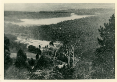
John Lundy-Clarke grew up in the Kalorama/Mt Dandenong area and later in life (1972-74) began to write a comprehensive history of the area working from an original settlement map in an effort to cover all areas. Harmony Vale was the name of the homestead built by early pioneer Jabez Richardson. The whole of the valley took on this name. The building lasted until 1933. The Silvan Dam was completed in 1932 and was full when this photograph was taken.Black and white photograph looking down over a forested area with a dam in the background. Copied from a Rose Series postcard c1933. Handwritten inscription on reverse by John Lundy-ClarkeRose Series photo of 1933 showing “Harmony Vale” still standing. Copied 1973 JLCharmony vale, silvan dam, jabez richardson -
 Mt Dandenong & District Historical Society Inc.
Photograph
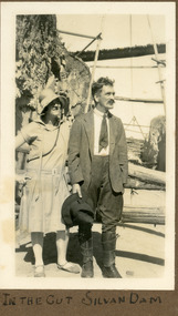
The photograph shows Ivy May Child standing with her father Ted Child at the Silvan Dam worksite. The construction of Silvan Dam took place between 1926 and the 1932 opening. Ivy May Child (1910 – 1989) was the daughter of Arthur Edward (Ted) Child (1878 – 1964) and Ethel May Madden (1888 – 1970). Ted Child was the son of Matthew Francis Child (1839 – 1933) and Martha Jeeves (1857 – 1926). He was the grandson of one of the early pioneers Francis Child. Ivy grew up on the family property on Childs Road and took many photographs. Most of these are glued into her photo album. The album covered the years from c1927 – 1932. Ivy married Henry William Burgess (1906 – 1968) in 1944. The photographs remain in their original state in the album with individual copies made. Black and white photograph showing a man and woman standing in a cutting. The woman is in a dress and wearing a shady hat. The man is wearing a jacket and jodhpur like trousers with leather gaiters. He is holding a wide brimmed hat.Written below photo in album: IN THE CUT SILVAN DAMivy child, ted child, silvan dam -
 Mt Dandenong & District Historical Society Inc.
Photograph
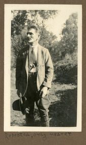
The man in the photograph is Ted Child. Photo (KAL0258) shows Ted wearing the same outfit standing in the cut at Silvan Dam so this is probably taken at the same place. This photograph is from the album of Ivy Child. Ivy May Child (1910 – 1989) was the daughter of Arthur Edward (Ted) Child (1878 – 1964) and Ethel May Madden (1888 – 1970). Ted Child was the son of Matthew Francis Child (1839 – 1933) and Martha Jeeves (1857 – 1926). He was the grandson of one of the early pioneers Francis Child. Ivy grew up on the family property on Childs Road and took many photographs. Most of these are glued into her photo album. The album covered the years from c1927 – 1932. Ivy married Henry William Burgess (1906 – 1968) in 1944. The photographs remain in their original state in the album with individual copies made. Black and white photograph with man in foreground in front of bushes. He is wearing a suit jacket. tie, jodhpur type trousers and leather gaiters. He is holding a wide brimmed hat in his right hand.Written below photograph in album: Repeated, only nearer.ted child, arthur edward child, ivy child, silvan dam -
 Mt Dandenong & District Historical Society Inc.
Photograph, Group at Maroondah Dam 1953, 1953
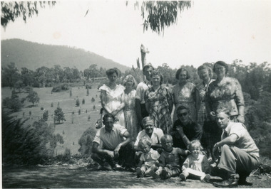
Small photograph of 11 adults and 3 children posing at Maroondah Dam in December 1953. Possibly an outing of workers from Woolrich Nursery.Handwritten on reverse in pencil: Maroondah Dam Dec 1953maroondah dam, woolrich nursery -
 Mt Dandenong & District Historical Society Inc.
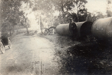
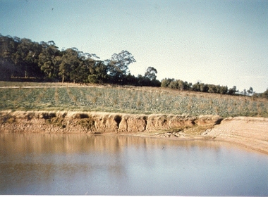
Photograph, At Site of Silvan Dam Pipes c1924, c1924
Man posed for photograph beside large water pipes destined for Silvan Dam. Car is parked at side of road.Black and white photograph with well dressed man in suit and hat standing beside large water pipes beside a treed road. Part of a car is visible to the left.silvan dam, pipe -
 Mt Dandenong & District Historical Society Inc.
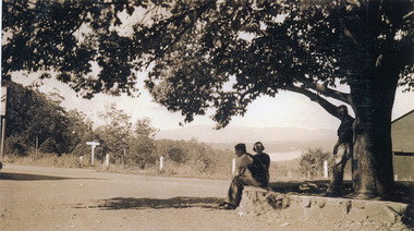
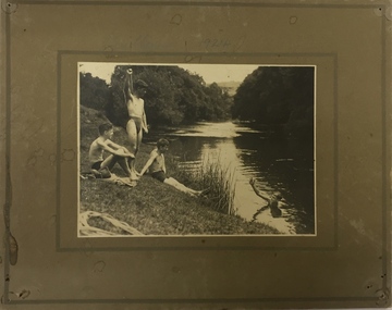
Photograph, FiveWays, Kalorama Looking Towards Silvan Dam, c1930
Close up of elm tree at FiveWays with a man and woman seated on stone bank and a man standing under the tree. Silvan Dam visible in distance. (2 copies)fiveways, kalorama, silvan dam -
 Southern Sherbrooke Historical Society Inc.
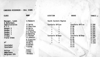
Information folder - Cardinia Reservoir
staff list donated to society by Dandenong Ranges Steiner SchoolInformation folder containing items pertaining to Cardinia Reservoir. Contents: -article "Huge Dam grows steadily", Sun, 3rd June 1975 (incomplete) -obituary of Allan Robertson, 'Dam fine infrastructure czar and community supporter', The Age, 10th December 2009 -staff list, Cardinia Reservoir, Melbourne & Metropolitan Board Of Works -trifold pamphlet, 'Cardinia Reservoir', Melbourne & Metropolitan Board of Works, n.d. but c.1973cardinia reservoir, melbourne & metropolitan board of works, allan gordon robertson, obe, oam, infrastructure, water -
 Southern Sherbrooke Historical Society Inc.
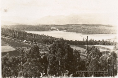
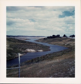
Postcard, Silvan Reservoir
Sepia-toned postcard featuring distant view of Silvan Dam. The middle ground shows cleared land all set out for agriculture, houses also visible. c. early 1930s -
 Southern Sherbrooke Historical Society Inc.
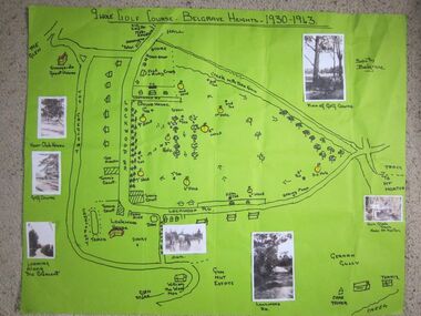
Photograph - 9 hole golf course-Belgrave Heights 1930-1943 map
Hand drawn map of Belgrave Heights and its 9 hole golf course, between 1930 and 1943 created by Betty de Coite nee Woods, who holidayed in the area with her family. Map drawn in marker. Photographs attached, including a view of the golf course, Fern Glade Tracks, Lockwood Rd, the dam at Marama Rd corner, The Crescent, the path near the club house, and a wagon near golf course. These photos were taken by members of the Woods family. Map highlights Lockwood House at the corner of Lockwood Rd, the 9 hole golf course, and Sunnyside guesthouse. Club house at Lockwood Rd is later the site of the Convention Centre. Above club house is Fred and Ruby Cook's House. -
 Southern Sherbrooke Historical Society Inc.
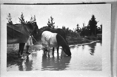
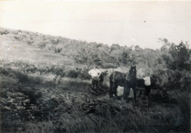
Photograph - Horses at dam, Belgrave Heights
Photograph of three horses drinking by damn near Marama Rd, Belgrave Heights. Behind the horse on the far left, a person is holding the horse. Their lower body is visible. Trees are in the background. Probably taken by Betty de Coite nee Woods or her parents. -
 Southern Sherbrooke Historical Society Inc.
Photograph - Photo-colour- Bill Montague boat
Colour photograph of Bill Montague on his boat, on the dam at the orchard at Narre Warren. Bill is the only person on his boat whichmoves alone in the water as the dam bank and trees surround him. -
 Southern Sherbrooke Historical Society Inc.
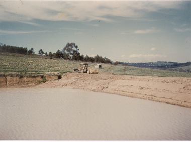
Photograph - Photo-colour- dam and tractor
Colour photograph of a tractor sitting near the dam at Narre Warren orchard. Green fields sit around the bank of the dam, with the water a brownish hue. -
 Southern Sherbrooke Historical Society Inc.
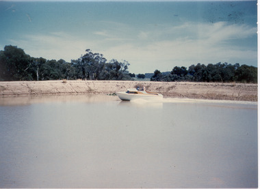
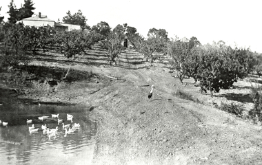
Photograph - The dam, Montague Orchards
Colour photo of the dam at Montague Orchards in Narre Warren North. Photo shows a partially filled dam with dug-out sides, a paddock with planted rows of glaucous green plants, and beyond that is bushland on a ridgeline. -
 Southern Sherbrooke Historical Society Inc.
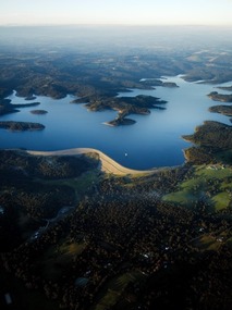
Photograph - Cardinia Reservoir from the air
Aerial photograph of Cardinia Reservoir taken in 2020, showing the face of the main dam wall. -
 Southern Sherbrooke Historical Society Inc.
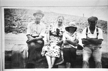
Photograph - Bill Slingo Senior and Junior, Ann Lord and Bill Lord
Photograph features a Graham Paige car at Lysterfield Reservoir. Bill Lord is dressed in dark trousers, open-necked shirt (with rolled-up sleeves), and a fedora. Ann Lord in a patterned summer dress. Bill Slingo junior in dark shorts, light shirt and sunhat, and Bill Slingo Senior in trousers with braces, a white shirt and a peaked cap. They are seated on a bench or wall. The Lords are seated on a satin-edged blanket. Behind the group a dam wall is visible. Photo was most likely taken by Alice Lord on the same day as VSSHP0267.03. . -
 Southern Sherbrooke Historical Society Inc.
Photograph - Cardinia Creek area, Narre Warren East, prior to dam works
A set of four colour photos showing the area around where Cardinia Reservoir is now located. The photos show various views of the hillsides and valleys prior to the damming of Cardinia Creek. Each photo has 'Belgrave Cardinia Creek' handwritten on the back. They date from prior to May 1970. The set was donated to the society by David Howe. 'Belgrave Cardinia Creek' handwritten on the back of each photo. -
 Southern Sherbrooke Historical Society Inc.
Photograph - Cardinia Reservoir filling, post 1973, Narre Warren East area
A set of five colour photos showing Cardinia Dam beginning to fill after its completion in 1973. One photo shows smoke or possibly dust rising on a distant hillside. The set was donated to the society by David Howe. -
 Kew Historical Society Inc
Photograph, Edwin Anderson, 1st Kew Scouts, Water Rescue Training, 1924
The 1st Kew Scouts was one of the first Scout Troops in Victoria, being formed in 1909. From 1927 they met in a magnificent Scout Hall in Disraeli Street, Kew until it was demolished in 1993. Still operating (in 2020) from their new Scout Hall on the corner of Kilby Road and Kellett Grove, Kew.1st Kew Scouts undertaking water rescue training at Bulleen. The photograph was most likely taken while the Scouts were camping beside the river one summer, with the programs generally including not only fun and games but also varying training activities. At the time many locals swam in the river. 1924 was well before the construction of major water storage dams and urbanisation of the upper reaches of the Yarra River, which significantly reduced downstream flows and water quality. These days, the Scouts tend to raft and canoe in the Yarra, rather than swim. On front: 1924. On reverse: photographer's stampscouts - kew, 1st kew scouts, yarra river, bulleen, water rescue training 1924 -
 Kew Historical Society Inc
Album - Photograph Album No.1, Henry Beater Christian, 1924-26
Henry Christian (c.1809-91), the grandfather of the photographer, was one of the first settlers in Kew. He arrived in Victoria with his wife Agnes and son Orlando in 1855 on the Gypsy Queen. He established a rope-making business in Bulleen Road by 1858 but was declared insolvent two years later. In his final years, he was celebrated as one of the oldest living settlers of the district. His son, Orlando Henry Beater Christian (c.1853-1930) became a member of the Hawthorn Band and a foundation member of the Willsmere Swimming Club. Orlando and his wife Elizabeth had four children of which Henry Beater Christian (1886-1962) was the oldest.An album of photographs, compiled by Henry Beater Christian (1886-1962) of Pakington Street, Kew, depicting individuals, natural and settled environments and the interactions between these worlds. Henry Christian, was a keen explorer, not just of his immediate environment but also of the Victorian wilderness. His major opus is contained in two albums in which he records, sometimes in majestic detail and on other occasions the intimate features of the natural world. His photographic travels during the 1920s, often in solitary ramblings but on other occasions with companions, recall the heroic landscape photography of an earlier era, pioneered by Nicholas Caire. In addition to their aesthetic value, the albums are historically significant records within the State of Victoria, of what is now a distant point in time, and of places that have become radically altered through human intervention.Digital copy of a 47-page photograph album containing 255 gelatinous silver images, loaned by Diane Washfold with permission given to digitise and hold a copy in our collection. The album contains a groups of photographic positives taken by Henry B Christian (a resident of Pakington Street), of places in Kew and throughout regional Victoria during the 1920s. The mainly sepia photographs, while small, are of a high resolution. Photographs are typically lightly glued onto pages. Locations are frequently identified by white or black ink, which in a number of cases is illegible due to wear.henry beater christian (1886-1962), landscape photography, photograph albums, kew (vic.) — yarra river, kew (vic.) — zig-zag bridge, kew (vic.) — macauley’s boathouse, studley park (vic.) — yarra river, wonderland — grampians (vic.), black spur (vic.), marysville (vic.), maroondah dam (vic.) — construction, warburton (vic.), cockatoo (vic.), bruthen (vic.), swan reach road (vic.), glen hills (vic.), lightning creek (vic.), omeo (vic.), glen wills (vic.), mt wills (vic.), sunnyside (vic), granite flat (vic.), toolangi (vic.), yea (vic, )., flowerdale (vic.), mt white law (vic.), baw baw (vic.), christian-washfold collection -
 Lilydale RSL Sub Branch
Book, Paul Brickhill, The Dam Busters, 1955
-
 Wonga Park Community Cottage History Group
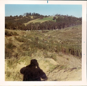
Photograph (sub-item) - Black and White, Cleaning out the dam on Heims’ property in 1930’s – view up hill towards Jumping Creek Road
-
 Wonga Park Community Cottage History Group
Photograph (Item) - Black and White, Wonga Park: Read's Dam, Orchard and House, c. 1931
Wonga Park: Read's Dam, Orchard and HousePhoto is named 14880016.jpg on CD -
 Wonga Park Community Cottage History Group
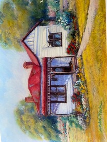
Photograph - Painting, The Hedge, Yarra Road Wonga Park
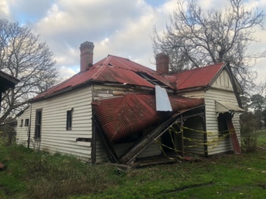
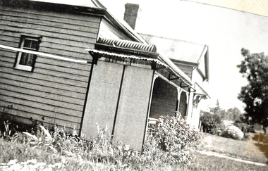
The Hedge, aka Thomas Knee's house. Thomas Samuel Knee (born c. 1881in Lilydale) married Jane Maggs c. 1912, Thomas Samuel Knee's father Thomas Knee (married to Sarah Hardidge and who it appears was also an orchardist in Yarra Road) was rated for the land as vacant land at the turn of the century (c. 1900) Thomas Samuel Knee rated as owner of vacant land (CA14B of over 20 acres1911-12 and as a house 1912-13, next year CA 14C added making a total of 39 acres. It appears that Thomas Samuel Knee and his wife Jane lived at the property until 1949 when they moved to Montrose. In 1949 it was purchased by Hubert Victor (Vic) Eggleton after they migrated from Banstead in Surrey England. They had four boys Peter (who did a lot of the farming with Gladys), Brian, Michael and Roger. It was mixed farming: lemons, cherries, eggs, chickens and Gladys bred Spaniel dogs too. They had 2 dairy cows and a draft horse. The farm was larger then and was subdivided at a later date. The big dam was added too. the painting of the house was painted by a cousin of the Lusks. Ownership: Thomas Samuel Knee 1912-1949, Eggletons, 1949 - c.1953, then Timms, c. 1953 - early 1970s then Lusks early 1970s to c. 2012. The Lusks built a new house and after that the old house had various tenants. -
 Wonga Park Community Cottage History Group
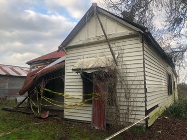
Photograph - Colour, The Hedge (Tom Knee's House) 278 Yarra Road Wonga Park in 2023
The Hedge, aka Thomas Knee's house. Thomas Samuel Knee (born c. 1881in Lilydale) married Jane Maggs c. 1912, Thomas Samuel Knee's father Thomas Knee (married to Sarah Hardidge and who it appears was also an orchardist in Yarra Road) was rated for the land as vacant land at the turn of the century (c. 1900) Thomas Samuel Knee rated as owner of vacant land (CA14B of over 20 acres1911-12 and as a house 1912-13, next year CA 14C added making a total of 39 acres. It appears that Thomas Samuel Knee and his wife Jane lived at the property until 1949 when they moved to Montrose. In 1949 it was purchased by Hubert Victor (Vic) Eggleton after they migrated from Banstead in Surrey England. They had four boys Peter (who did a lot of the farming with Gladys), Brian, Michael and Roger. It was mixed farming: lemons, cherries, eggs, chickens and Gladys bred Spaniel dogs too. They had 2 dairy cows and a draft horse. The farm was larger then and was subdivided at a later date. The big dam was added too. the painting of the house was painted by a cousin of the Lusks. Ownership: Thomas Samuel Knee 1912-1949, Eggletons, 1949 - c.1953, then Timms, c. 1953 - early 1970s then Lusks early 1970s to c. 2012. The Lusks built a new house and after that the old house had various tenants. -
 Wonga Park Community Cottage History Group
Photograph - Black and White, The Hedge (Tom Knee's House) 278 Yarra Road Wonga Park in 1949
The Hedge, aka Thomas Knee's house. Thomas Samuel Knee (born c. 1881in Lilydale) married Jane Maggs c. 1912, Thomas Samuel Knee's father Thomas Knee (married to Sarah Hardidge and who it appears was also an orchardist in Yarra Road) was rated for the land as vacant land at the turn of the century (c. 1900) Thomas Samuel Knee rated as owner of vacant land (CA14B of over 20 acres1911-12 and as a house 1912-13, next year CA 14C added making a total of 39 acres. It appears that Thomas Samuel Knee and his wife Jane lived at the property until 1949 when they moved to Montrose. In 1949 it was purchased by Hubert Victor (Vic) Eggleton after they migrated from Banstead in Surrey England. They had four boys Peter (who did a lot of the farming with Gladys), Brian, Michael and Roger. It was mixed farming: lemons, cherries, eggs, chickens and Gladys bred Spaniel dogs too. They had 2 dairy cows and a draft horse. The farm was larger then and was subdivided at a later date. The big dam was added too. the painting of the house was painted by a cousin of the Lusks. Ownership: Thomas Samuel Knee 1912-1949, Eggletons, 1949 - c.1953, then Timms, c. 1953 - early 1970s then Lusks early 1970s to c. 2012. The Lusks built a new house and after that the old house had various tenants. -
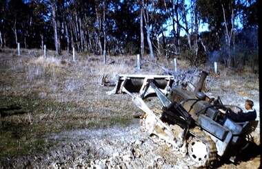 Wonga Park Community Cottage History Group
photograph, dam making, c 1940 for 1003 c1960 for 1003-1
Ernie Kear and his son Bruce were local excavators and involved in many projects around Wonga Park requiring bull dozing, in particular clearing land for orchards, building dams etcEarly history of Wonga Park orchard growing district. Early dams were built by horse and scoop on the back which was handled by the orchardist, or the dam builder but later replaced by bulldozersErnie Kear excavating a dam in Wonga Park c 1940 no hard copy electronic only -
![Newspaper - Newspaper Clipping - Digital Image, Diamond Valley News, [Fishing in the Yarra 1999], 13/10/1999](/media/collectors/4f729f5697f83e03086015b8/items/674aa8d28f48af8ae71becf3/item-media/674aa9238f48af8ae71bf3e1/item-fit-380x285.jpg) Greensborough Historical Society
Greensborough Historical SocietyNewspaper - Newspaper Clipping - Digital Image, Diamond Valley News, [Fishing in the Yarra 1999], 13/10/1999
The Walker family are seen fishing in the Yarra in preparation for the Greensborough Angling Club's family fishing day at Sugarloaf Dam.Digital copy of newspaper articlegreensborough angling club, sugarloaf dam, jim walker