Showing 2485 items
matching yarra yarra
-
 Heidelberg Golf Club
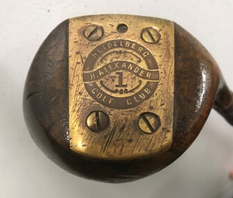
Leisure object - Golf club, Harry Alexander No.1 wood, 1927-1932
... Previously greenkeeper at Yarra Yarra Golf Club, Harry... Previously greenkeeper at Yarra Yarra Golf Club, Harry Alexander ...Previously greenkeeper at Yarra Yarra Golf Club, Harry Alexander joined Heidelberg Golf Club in June 1927 to 'set out the new links'. He was the golf professional at HGC from 1927-1932. This club is inscribed with his name and that of the HGCMetal shaft and wooden head, leather grip.On brass plate on base of head: "H. Alexander Heidelberg Golf Club 1"heidelberg golf club, golf clubs, woods, harry alexander, golf professionals -
 Ringwood and District Historical Society
Map, Plan of the Parish of Warrandyte County of Evelyn - 1841
... Selectors' names and property locations between Yarra Yarra River... and property locations between Yarra Yarra River (Warrandyte ...Blueprint copy of Survey Map W27 detailing original Selectors' names and property locations between Yarra Yarra River (Warrandyte) and Mullum Mullum Creek (Ringwood). List of Parish map references including property bearings, distances in Links, and markings on trees. Pound Bend area of Warrandyte marked as Reserve For Aborigines. Descriptive remarks include areas marked "scrubby, flat, sandy soil". Several other references faded and illegible.(Map) by T.H. Nutt Feb 3 1841. -
 Lakes Entrance Historical Society
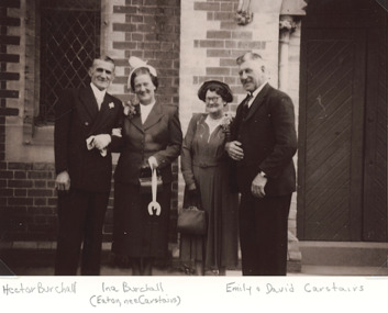
Photograph, Marriage of Hector Burchell to Ina Eaton nee Carstairs 1953, 1953
... Presbyterian Church South Yarra South Yarra Victoria...South Yarra, Victoria, Australia... Presbyterian Church South Yarra South Yarra Victoria Wedding Social ...with Inas parents Emily and David Carstairs at St Andrews Presbyterian Church South Yarra South Yarra VictoriaBlack and white photograph taken at the marriage of Hector Burchell to Ina Eaton nee Carstairs wedding, social history, religion -
 Upper Yarra Museum
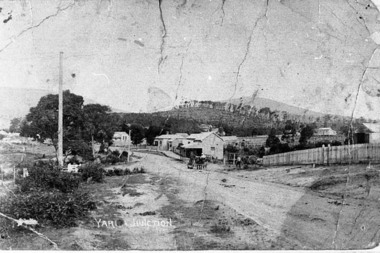
Negative Photographic Reproduction, Main St Yarra Junction
... Main St Yarra Junction...early main street yarra junction...03042 Main street opposite the railway station, 1909, Yarra...Upper Yarra Museum Old Railway Station 2415C Warburton ...03042 Main street opposite the railway station, 1909, Yarra Junction. Upper Yarra Shire 1888-1988 Centenary collection. Black & white Negative, scanned at 600 dpiearly main street yarra junction -
 Ringwood and District Historical Society
Photograph, Warrandyte Historical Society Newsletters nos. 76-84
... Street Yarra Yarra Mining Company Dr Owen's Puddling Machine 1927... bus service Brackenbury Street Yarra Yarra Mining Company Dr ...Digitised WHS newsletters from December 1990 (no. 76) to October 1990 (no. 84). Sent to Secretary of the Ringwood Historical Research Group, Jack Lindsay.Noteable articles:- Earl Stewart bus service Brackenbury Street Yarra Yarra Mining Company Dr Owen's Puddling Machine 1927 bushfires Schult Steven Houghton Taffy Jones Great Southern Hill Caledonia Gold Mine Mary Hill - South Warrandyte Post Office Artists - Nutter Buzacott, Frank Crozier, Penleigh Boyd, William Frater, Christine Gray-Aldor Warrandyte Primary School Potter's Cottage -
 Eltham District Historical Society Inc
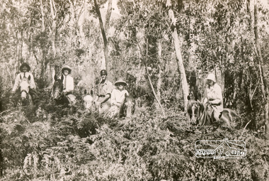
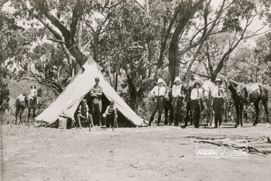
Photograph, Bend of Islands, c.1928
... at a bend of the Yarra River near Watsons Creek. It is located near... at a bend of the Yarra River near Watsons Creek. It is located near ...Bend of Islands is named after a group of small islands at a bend of the Yarra River near Watsons Creek. It is located near the town of Kangaroo Ground. The locationn was a long time favourite spot for locals and visitors to fish and swim in the river. This is one of a series of four photographs that depict a mainly young group of people recreating in the area, particularly enjoying horse riding. Possibly weekend campers. Photos taken about 1926-1928. In 1938 "The Argus" advertised weekend cabins at the Bend of Islands estate 5-are Yarra Yarra frontage in the Christmas Hills Gorge ideal for weekend cabins. "Bathing, fishing, canoeing, shooting may be enjoyed in ideal surroundings". Black and white photograph (reproduction)Bend of Islands, c.1928 bend of islands, horse riding, camping, tent -
 Eltham District Historical Society Inc
Photograph, Bend of Islands
... at a bend of the Yarra River near Watsons Creek. It is located near... at a bend of the Yarra River near Watsons Creek. It is located near ...Bend of Islands is named after a group of small islands at a bend of the Yarra River near Watsons Creek. It is located near the town of Kangaroo Ground. The locationn was a long time favourite spot for locals and visitors to fish and swim in the river. This is one of a series of four photographs that depict a mainly young group of people recreating in the area, particularly enjoying horse riding. Possibly weekend campers. Photos taken about 1926-1928. In 1938 "The Argus" advertised weekend cabins at the Bend of Islands estate 5-are Yarra Yarra frontage in the Christmas Hills Gorge ideal for weekend cabins. "Bathing, fishing, canoeing, shooting may be enjoyed in ideal surroundings". Black and white photograph (reproduction)Bend of Islands bend of islands, camping, tent, horse riding -
 Eltham District Historical Society Inc
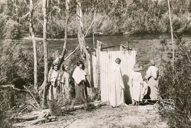
Photograph, Bend of Islands, c.1926
... yarra river... at a bend of the Yarra River near Watsons Creek. It is located near... at a bend of the Yarra River near Watsons Creek. It is located near ...Bend of Islands is named after a group of small islands at a bend of the Yarra River near Watsons Creek. It is located near the town of Kangaroo Ground. The locationn was a long time favourite spot for locals and visitors to fish and swim in the river. This is one of a series of four photographs that depict a mainly young group of people recreating in the area, particularly enjoying horse riding. Possibly weekend campers. Photos taken about 1926-1928. In 1938 "The Argus" advertised weekend cabins at the Bend of Islands estate 5-are Yarra Yarra frontage in the Christmas Hills Gorge ideal for weekend cabins. "Bathing, fishing, canoeing, shooting may be enjoyed in ideal surroundings". This photo seems to be depicitng women waiting to use the shower near the river, or are they going swimming?Black and white photograph (reproduction)Bend of Islands, c.1926 bend of islands, camping, shower block, yarra river, swimming -
 Eltham District Historical Society Inc
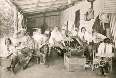
Photograph, Bend of Islands, c.1926
... at a bend of the Yarra River near Watsons Creek. It is located near... at a bend of the Yarra River near Watsons Creek. It is located near ...Bend of Islands is named after a group of small islands at a bend of the Yarra River near Watsons Creek. It is located near the town of Kangaroo Ground. The locationn was a long time favourite spot for locals and visitors to fish and swim in the river. This is one of a series of four photographs that depict a mainly young group of people recreating in the area, particularly enjoying horse riding. Possibly weekend campers. Photos taken about 1926-1928. In 1938 "The Argus" advertised weekend cabins at the Bend of Islands estate 5-are Yarra Yarra frontage in the Christmas Hills Gorge ideal for weekend cabins. "Bathing, fishing, canoeing, shooting may be enjoyed in ideal surroundings". Was this a church group? This photo depicts individuals "resting" on a verandah undertaking various solo activities including listening to their gramophone.Black and white photograph (reproduction)Bend of Islands, c.1926 bend of islands, camping, recreation, gramophone, group, campers -
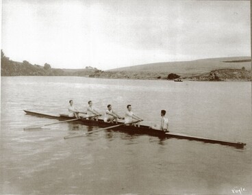 City of Warrnambool Rowing Club
Photograph
... performance they put in at the Yarra Yarra and Albert Park Regattas... performance they put in at the Yarra Yarra and Albert Park Regattas ...The photograph is of the 1925 Warrnambool Rowing Club Lightweight four- they raced at the clubs annual Boxing Day Regatta. H Sherriff was stroke J MacNamara (3 seat) C Earls (2 seat) L Halliwell (bow), T Fary was cox. The Regatta that year had three events and the other usual aquatic events were cancelled due to poor weather. Mr W. A. Hope was regatta secretary. It is recorded on page 109 of the 1914-35 minute book that 'Mr. Meckin, the president, said he had much pleasure in moving a motion of long salutation to the light weight four in recognition of the fine performance they put in at the Yarra Yarra and Albert Park Regattas...Mr. Hope seconded and added...credit to the crew..a fine lesson to some of the older members in perseverance..'Black and white photograph of a Warrnambool Rowing Club crew of 5 in a rowing boat on the Hopkins River, Warrnambool. Taken in 1925. Under the photograph is the name of the crew and year it was taken: Lightweight fours 1925 H Sherriff stroke J MacNamara C Earls L Halliwell bow T Fary coxrowing, warrnambool rowing club, hopkins river, city of warrnambool rowing club -
 Bendigo Historical Society Inc.
Document - NORMAN OLIVER COLLECTION: SPEECH NOTES 9 DECEMBER 1950
... . Galvin M.L.A., Mr Ted Mullett (Yarra Yarra tribe), Mr r. K... Ted Mullett (Yarra Yarra tribe), Mr r. K. Dodgson M.L.A., Hon ...The Norman Oliver collection. Norman Oliver was three times Mayor of Bendigo - 1950-51, 1964-65, 1970-71. Fifteen pages, all but one typed in upper case. The pages are not numbered in sequence. Held together with a paper clip. In the format he used for his talks on 3BO 'The Mayor Speaks'. Topics include : Grants for Bendigo public works, Local Government Conference, taxis, the visit of the Chief Secretary for the Bendigo Cup, and Oliver's comments on the Melbourne play 'The Highwayman', set in Bendigo. Other names include Hon. J. H. Lienhop M.L.C., Mr Smithers, Mr Forrestal, Mr Strom, Mr Harold Alexander (South Melbourne Town clerk), Mr Calwell M.H.R., Mr Menzies, Mr Matthews, Hon.Cr. L. W. Galvin M.L.A., Mr Ted Mullett (Yarra Yarra tribe), Mr r. K. Dodgson M.L.A., Hon. Paul Jones M.L.C., Judge Norris,bendigo, council, speech notes, norman joseph oliver , councillor norman oliver. 3bo 'the mayor speaks'. -
 Southern Sherbrooke Historical Society Inc.
Draft Precinct Brochures - Shire of Yarra Ranges, "Shire of Yarra Ranges Neighbourhood Character Study"
... Draft Precinct Brochures - Shire of Yarra Ranges..."Shire of Yarra Ranges Neighbourhood Character Study"... prepared by the Shire Of Yarra Ranges for public comment. Areas... Belgrave Heights 3160 yarra-valley-and-the-dandenong-ranges ...Collection of Draft Precinct Brochures in ring binder prepared by the Shire Of Yarra Ranges for public comment. Areas include: Belgrave, Coldstream, Chirnside Park, Healesville, Kilsyth, Lilydale, Monbulk, Montrose, Mooroolbark, Mt. Evelyn, Seville, Seville East, Tecoma, Upwey, Wandin North, Warburton, woori Yallock, Yarra Glen and Yarra Junction. -
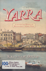 Eltham District Historical Society Inc
Book, Kristin Otto, Yarra : a diverting history of Melbourne's murky river / Kristin Otto, 2005
... Yarra : a diverting history of Melbourne's murky river...yarra river... the Yarra Yarra. In September 1835 he was at the Turning Basin... the Yarra Yarra. In September 1835 he was at the Turning Basin ..."It was John Wedge, Batman's private surveyor, who named the Yarra Yarra. In September 1835 he was at the Turning Basin with some Kulin and heard them identify the river as it came over the Falls as, he wrote, 'Yarrow Yarrow'. It was only some months later that Wedge discovered they had been referring to the pattern and movement of water over the Falls, not the river itself. And ever since, it has been the Yarra's fate to be misunderstood: maligned for its muddiness, ill-used as sewer and tip; scooped, sculpted, straightened and stressed, 'cleaned up' to the detriment of its natural inhabitants; built-over, under and beside; worked mercilessly and then bridged almost to maritime extinction. In Kristin Otto's superbly entertaining new history, the whole sorry tale is laid bare. From the creation stories of Kulin owners and geologist blow-ins (and Robert Hoddle's bad-tempered expedition to the headwaters) to the twenty-first-century waterside building boom, Otto traces the course of Melbourne's murky river. Erudite, affectionate and witty, with more meanders and diversions than the river itself, Yarra is both a fascinating read and a fitting tribute to the 'noble stream'." -- Publisher's website.Paperback; [viii], 245 p. : illus., maps ; 24 cm.ISBN 1920885781yarra river -
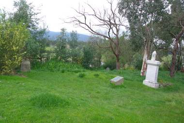 Victorian Interpretive Projects Inc.
Photograph - Colour, Clare Gervasoni, Corenderrk Cemetery, 31/08/2011
... of the Yarra Yarra tribe’, became the leader, the Ngurungaeta... of the Yarra Yarra tribe’, became the leader, the Ngurungaeta ...In 1860 the Wurundjeri Elder, Wonga, petitioned the Victorian Parliament for a piece of land in his people’s own country where he could establish a settlement. The land later named Coranderrk was granted. When Wonga died in 1875 his nephew William Barak, known by settlers as ‘King William, last chief of the Yarra Yarra tribe’, became the leader, the Ngurungaeta. William Barak believed strongly in justice for his people, and time and again made the arduous walk to Melbourne to petition to Parliament and to Queen Victoria for his people. ‘Freedom for our lifetime’, he said. The community at Coranderrk welcomed Aboriginal people displaced from other parts of Victoria; they established an economically self-sufficient settlement by growing and marketing hops. Barak negotiated with the Victorian Government officials as they made promises and broke promises. They finally promised to export the whole of a hop harvest of one year. The people worked around the clock to fill the contract; the Government pocketed the proceeds. The community never recovered. Barak died in 1903— a broken-hearted man. (from http://www.sosj.org.au/_uploads/_cknw/files/Corenderrk.pdf) Artist William Barak is buried in this cemetery.Photographs of graves in grass and bushland. It is the Corenderrk Cemetery, and is associated with the former Corenderrk Aboriginal Reserve.corenderrk, wurundjeri, barak, aborigines, aboriginal, cemetery, grave, barak, jemima dunolly -
 Melbourne Tram Museum
Ephemera - Calendar, Yarra Trams, 2006
... Yarra Trams..., phone numbers for contacts at each depot, Yarra Trams logo...Yarra Trams... Trams tramways Yarra Trams Calendar Printed A4 calendar on gloss ...Printed A4 calendar on gloss paper, full colour providing dates for 2007 including public and school holidays, Grand Prix, 12th Fina World Championships, Pay weeks and Daylight saving, phone numbers for contacts at each depot, Yarra Trams logo, Yarra Trams "Love your trams" badge and Transport Health Insurance details. Two copies held.trams, tramways, yarra trams, calendar -
 Bendigo Military Museum
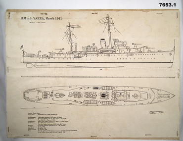
Drawing - DESIGN DRAWING, NAVAL
... HMAS YARRA... WW2. First HMAS YARRA which was a Yarra Class sloop...1. Drafting drawing of HMAS YARRA March 1941 from side...1. Headed 'HMAS YARRA March '41: Scale 1 inch = 16 feet. 2... WW2. First HMAS YARRA which was a Yarra Class sloop ...Schematics and details of Navy ships manufactured during WW2. First HMAS YARRA which was a Yarra Class sloop, commissioned Jan 1936 and sunk by Japanese on 4th March 1942. Second ship was HMAS WARRAMUNGA, a Tribal Class Destroyer Commissioned No. 42 and scrapped Jan 1963.1. Drafting drawing of HMAS YARRA March 1941 from side profile and top down profile on white paper stapled to cardboard. Includes description of all details of ship. 2, Drafting drawing of HMAS WARRAMUNGA March 1943 with side profile and top down profile.1. Headed 'HMAS YARRA March '41: Scale 1 inch = 16 feet. 2. Headed 'HMAS WARRAMUNGA" March '43: Scale 1 inch = 24 feet.hmas yarra, hmas warramunga -
Eltham District Historical Society Inc
Document - Folder, Newman, Charles
... Andersons Station on the Yarra River... settler on the Yarra River at Templestowe after serving in India... settler on the Yarra River at Templestowe after serving in India ...British army officer Major Charles Newman was an early settler on the Yarra River at Templestowe after serving in India in the East India Company. Later be married and moved to Tasmania, farming at Black Brush near Pontville. In 1835 he came to the Port Phillip District and explored the Yarra River, returning with his family. David Crockett and Hazel Poulter researched, respectively, Charles Newman and the Templestowe area, identifying the Newman house, Pontville, on the Yarra banks. David Crockett also researched James and Anne Anderson. Contents Newspaper article: "David fills in the gaps", Diamond Valley News, 16 December 1986.29 October 1985, p62. Story of Charles Newman and of David Crockett and Hazel Poulter's researches. Letter, A (Tony) B Owen to Eltham Historical Society, 12 March 2018, enclosing information about Major Charles Newman. Email, Eltham District Historical Society to Tony Owen, acknowledging receipt of information about Major Charles Newman. Photocopy of pages from "Glimpses of Life in Victoria", pp38-43. Flier, "Heritage Events in Nillumbik, 2005". Photocopy of pages from unidentified volume, chapter headed "The Bush", and part chapter IV "Bushrangers". Warrandyte Historical Society publication "The Wurundjeri Clan of the Kulin". Whitehorse Manningham Heritage Network search results for "Andersons Station on the Yarra Yarra", "A brief history of Warrandyte", "The branch is broken", "Melbourne's historic home", "Land with infamous past", "Charles Newman's original grave at Monckton", and "Site of Major Newman's land". Photocopy of pages from "Templestowe - a folk history", Hazel Poulter, 1985,: "The squatter, Major Charles Newman".Newspaper clippings, A4 photocopies, etccharles newman, british east india company, templestowe vic, warrandyte vic, david crockett, hazel poulter, james anderson, anne anderdon, a b owen, wurundjeri clan of the kulin, andersons station on the yarra river -
 Eltham District Historical Society Inc
Slide, Site of proposed Yarra Brae Dam, Jul. 1973
... Site of proposed Yarra Brae Dam...Yarra Brae Dam... of Sugarloaf Reservoir. Two dams were to be built, one across the Yarra... of Sugarloaf Reservoir. Two dams were to be built, one across the Yarra ...With an increasing need to grow Melbourne's water supply, in 1973, the State Government announced plans for the development of Sugarloaf Reservoir. Two dams were to be built, one across the Yarra from the Yarra Brae property in Wonga Park to the Bend of Isles. Water was to be pumped from this dam to the higher level Sugarloaf Reservoir. The proposed extensive flooding of large numbers of properties resulted in significant community backlash and ultimately abandonement of the proposed Yarra Brae dam.35 mm colour positive transparency (x 3) Mount - Kodak Kodachrome Cardyarra brae dam -
 Federation University Historical Collection
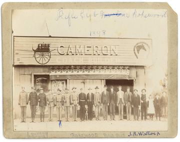
Photograph, Madeley Photo, Rokewood Rifle Club, 1898, 1898
... helping to build the Spencer Street Bridge over the Yarra Yarra... Street Bridge over the Yarra Yarra, as it was known then, before ...In 1901 Cameron was captain of the Rokewood Rifle Club. John Cameron was a Rokewood blacksmith in 1902. John (Jack) Richard Watson was the son of Thomas Watson (10/11/1838 - 27/04/1920) and Emma Eliza Jane Phillips (25/05/1844 - 12/10/1925) and was born at Yendon on 16/12/1876 and died 11/10/1973 aged 96 at the Wimmera Base Hospital in Horsham while residing in Murtoa. Still a teenager Thomas reached Melbourne in the 1850's and found work helping to build the Spencer Street Bridge over the Yarra Yarra, as it was known then, before making his way to the Ballarat Goldfields. After being tricked out of a claim he sought work with the Victorian Railways, and later acquired a farm at Yendon. Emma Phillips was born in Geelong and had moved with her mother to Ballarat. Emma was a member of the Ballarat Philharmonic Orchestra and sang in the choir of St Pauls Church in East Ballarat, where they were married. Jack worked in the gold mining industry - firstly as a braceman at the New Kohinoor Mine at Sebastapol and then to a mine at Rokewood, both times following his older brother Frederick George. He later worked in 15 different mines before changing occupations. He was employed as an engine driver for the Murtoa Waterworks Trust at the Murtoa Power Station when he lost his lower left arm when it was caught in an engine belt in 1929. Jack married Edith Emma Yung (01/07/1887 - 05/10/1988 ) who was born at Allendale and died aged 101 at Wendouree after livivng most of her married life at Murtoa. They had five children all born in Murtoa: Richard Henry (Harry); Edith 'Alice'; Grace; Ernest Alfred (Alf) and Jonn Grenville (Gren). They were married at Yendon. Sepia photo of eighteen men and one girl. Eight are in uniform, and two are identified as Boer War soldiers. They all stand in front of Cameron Coach Builders showroom and workshop. The person fifth from the left is J.R. Watson.Front top Rifle Club (Murtoa - crossed out) Rokewod 1898; Lower LHS South Africa Boer War; C - Rokewood Rifle Club; Loer RHS J.R.Watson. Sign on Building: Agricultural & Mining & Smith above Cameron Coach Builder. Verso: Madeley Photo Corindhap plus a signature.corindhap, rokewood, rokewood rifle club, j.r. watson, cameron coach builder, john cameron, emma eliza jane phillips, thomas watson, john richard watson, edith emma watson -
Eltham District Historical Society Inc
Folder, Robert Lowman, 1882
... Lowman's Hotel or Lowman's Folly on Osborne Road - Yarra Glen Road... Lowman's Hotel or Lowman's Folly on Osborne Road - Yarra Glen Road ...Robert Lowman, Christmas Hills, 1882 Lowman built his Lowman's Hotel or Lowman's Folly on Osborne Road - Yarra Glen Road, Christmas Hills in the 1870s when the main road from Christmas Hills to Yarra Glen (then "Yarra Flats") used to follow the present Eltham -Yarra Glen Road to Osborne Road, then followed that to Mt Wise Road and down the escarpment. Years later a new road was opened leaving Lowmna's Hotel high and dry to gain renown as "Lowman's Folly". It closed in the early 1890s. See Christmas Hills Past and Present Brochure (Yarra Glen District Historical Society), 2004Folderrobert lowman, hotelier, christmas hills -
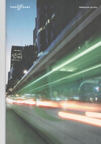 Melbourne Tram Museum
Pamphlet, Yarra Trams, "Melbourne All Over", c2005
... Yarra Trams... by Yarra Trams c2005, after Yarra took over the whole...Yarra Trams... Trams tramways Yarra Trams Melbourne Transdev Transfield Metlink ...Pamphlet - A4 - 24 pages - printed full colour of white paper, centre stapled titled "Melbourne All Over" published by Yarra Trams c2005, after Yarra took over the whole of the Melbourne system. Covers Yarra vision for its operations, the partnership between Transfield and Transdev, accessibility, Metlink and ticketing, staff, customer service, Melbourne's cultural aspects, performance and contact addresses. Photos of 856, 3013, 3005 and 2010 Two copies held.trams, tramways, yarra trams, melbourne, transdev, transfield, metlink, melbourne, tram 856, tram 3013, tram 3005, tram 2010 -
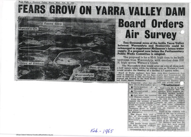 Eltham District Historical Society Inc
Newspaper articles, Yarra Dam
... Yarra Dam...Yarra Dam... of the Yarra Dam at Warrandyte: Yarra Dam at Warrandyte not the only... construction of the Yarra Dam at Warrandyte: Yarra Dam at Warrandyte ...Two newspaper articles discussing the proposed construction of the Yarra Dam at Warrandyte: Yarra Dam at Warrandyte not the only alternative - Mr Stokes, Diamond Valley Mirror, 14 October, 1964 Fears grow on Yarra Valley Dam Board orders air surey, Diamond Valley Mirror, 24 February 1965 The Sugarloaf Reservoir Project, including a major pumping station and water treatment plant was completed, increasing Melbourne's total storage capacity by 95,000 million litres in 1981.2 pageswater supply, sugarloaf, reservoir, christmas hills, yarra dam, warrandyte -
 Eltham District Historical Society Inc
Photograph, Birch Cottage, Eltham-Yarra Glen Road, c.1970, 1970
... Birch Cottage, Eltham-Yarra Glen Road, c.1970... samuel birch, eltham-yarra glen road, honor mary birch, honor... in the late 1960s, he would enjoy driving out to Yarra Glen... in the late 1960s, he would enjoy driving out to Yarra Glen ...GC advised that when they first arrived in Eltham in the late 1960s, he would enjoy driving out to Yarra Glen. The Eltham-Yarra Glen road was unmade at the time. He passed this residence on the north side of the road. It was totally remote. GC found the juxtaposition of this little cottage with its surburban wire gate out in the remoteness of the landscape intriguing. Since then the road has been reconstructed and diverted away from the cottage which is now owned by Parks Victoria.Digital TIFF file Scan of 35mm Ilford HP4 black and white transparencyIlford HP4birch cottage, christmas hills, early settlers, edwin samuel birch, eltham-yarra glen road, honor mary birch, honor mary williams, john hill, watsons creek -
 Eltham District Historical Society Inc
Photograph, Liz Pidgeon, Public Records Office Victoria (PROV) visit to Eltham Justice Precinct, 20 Apr 2018
... were described as being situated at Lower Plenty, Yarra Yarra... were described as being situated at Lower Plenty, Yarra Yarra ...The original Shire of Eltham was founded in 1871. Prior to its founding, the district was managed by the Eltham District Road Board, which was established in 1856. The initial rate assessment commenced in 1857 for the year ending October 14, 1858. The honour of being recorded with the first assessment went to a farm of 110 cultivated acres at Lower Plenty, owned by John Porter and occupied by Albert Baines. It was assessed at 6d/acre providing for a rate income of £2 15s. In July 2017, officers at Nillumbik Shire Council discovered some early Eltham Road District Assessment books and donated them to the Eltham District Historical Society. The seven volumes were the district’s first six years of rate assessments. This was a unique and significant record of early settlers in the pre-Shire of Eltham. They immediately became one of the oldest and most valuable items in our collection. An article on page 5 in the Eltham and Whittlesea Shires Advertiser, Friday, 21 November, 1941 titled: ‘District’s Early History‘ states: “The first rate book which is still in existence at the Shire Office is for the year ending October 14, 1858 and is probably the best record possible to indicate the development of the district. At the time properties were rated as follows: Cultivated land. 6d. per acre; pasture land, 1d. per acre: estimated annual value of buildings, etc., 6d in the (pound). The total amount of rate recorded for the year was £153/14/8. Properties were described as being situated at Lower Plenty, Yarra Yarra, Eltham, Lower Eltham, Kangaroo Ground, Yarra Flats, Diamond Creek and the Yarra.” Given the precious nature of this collection, priority was given to digitise the rate books and place them in suitable archival storage to minimise further handling. Subsequent discussion amongst our Collections team arrived at the conclusion that the most appropriate home for this valuable record was the Public Record Office Victoria (PROV), the archive of the State Government of Victoria and who are charged with archiving and caring for all Government related records. An approach was made to PROV who confirmed these records would complete their collection of rate assessment books for Eltham. At a small ceremony held Friday, April 20 at the Local History Centre, Eltham, members of the Society and our Collections team, along with Ms. Vicki Ward, MP for Eltham, presented the seven volumes for 1858-1863 along with the complete set of digital files to Mr. David Taylor, Community Archives Manager and Mr. Charlie Farrugia, Senior Collection Advisor, Public Record Office Victoria.Born Digitalassessment ledger, donation, eltham courthouse, eltham road district, local history centre, public records office victoria (prov), rate books, eltham district road board -
 Melbourne Tram Museum
Document - Folder with papers, Yarra Trams, "M>Tram Q&A pack", Feb. 2004
... Yarra Trams..." issued at the time Yarra Trams entered into the new partnership...Yarra Trams... Trams tramways Yarra Trams M>Tram Victorian Government Transport ...Set of seven press releases and other information documents contained within a white card board folder marked ""M>Tram Q&A pack" issued at the time Yarra Trams entered into the new partnership arrangement to merge M>Tram operations into Yarra and operate a single tram network. Has a M>Tram logo on the front cover. All dated 19/2/2004 unless otherwise noted and all A4 size on white paper. .1 - folder with following papers: .2 - Single page letter from Des Davies Manager Human Resources Yarra Trams to all M>Tram staff. .3 - single page letter from Colin Nicol and Peter Anderson Receivers of M>Tram at KPMG to all M>Tram, M>Train and Bayside Maintenance staff. .4 - Media Release from Connex group, 2 pages, "Connex Awarded Melbourne Train Franchise" with Veolia and Connex logos. .5 - Media release from Yarra Trams, 4 sheets, 7 pages, from Yarra Trams "Yarra Trams services to expand across the entire Melbourne Tram network" .6 - Media release from the Premier of Victoria - 5 sheets including two fact sheets - "Stability returns to State's tram and train system" .7 - M>Tram "Staff Update - Refranchising Announcement" - two pages - signed by Bernie Carolan .8 - DL size three fold pamphlet, "New Public Transport Partnerships" published by Victorian Government Dept. of Infrastructure, with message from Peter Batchelor, Minister for Transport.trams, tramways, yarra trams, m>tram, victorian government, transport, press release, media release, connex -
 Eltham District Historical Society Inc
Photograph - Digital Photograph, Alan King, Diamond Creek, Barak Bushlands, Eltham, 2008
... corridor linking the Yarra River to the Kinglake National Park.1... corridor linking the Yarra River to the Kinglake National Park.1 ...A habitat corridor and it strengthens the community. Published: Nillumbik Now and Then / Marguerite Marshall 2008; photographs Alan King with Marguerite Marshall.; p185 Barak Bushlands lie west of the Diamond Creek on the corner of Falkiner Street and busy, noisy Main Road. They form part of an important habitat corridor linking the Yarra River to the Kinglake National Park.1 Manna Gums, tawny frogmouths and platypuses are some of the indigenous plants and animals that have made their home there. The bushlands are the result of more than nine years of hard work by the local community with the Nillumbik Council, to transform a degraded flood plain into this refuge of natural beauty. In 1997, shortly after moving into the new Riverside Estate on Falkiner Street, Eltham, several residents noticed the sorry state of the Diamond Creek and surrounding area. Part of it was used as a cow paddock and although small patches of vegetation survived, the area was infested with weeds, rabbits, rubbish and drainage from the housing estate. At various times the 4.4 hectares had been used as a market garden and for shire stock piles. The residents began to restore the area by revegetating land along the Diamond Creek. In 1998 they established the Friends of the Diamond Creek Falkiner Street Reserve2 and 35 families joined from the 90-house Estate. Carolyn Mellor, as the Friends’ Land Manager, undertook a four-year horticulture course to guide this massive project for a volunteer organisation. Since 1999, she has been the Friends’ President. In 1999 the Friends urged the Nillumbik Council to undertake a feasibility study into establishing a wetland system and urban forest. Work began in 2002 with Nillumbik Council funding the project, supplemented by government grants. The Friends also received grants from Melbourne Water and Parks Victoria. Aided by the Friends and other community members, the Council created the Barak Bushlands consisting of a forest, a wetland, a bridge, a path and open space. The beautiful wetland treats most of the estate’s stormwater runoff. Storm water is filtered through plants in the wetland ponds then is released slowly into the billabong, before flowing into the Diamond Creek. The wetland also helps to minimise flooding and the improved water quality provides a flora and fauna habitat. The Friends and other volunteers planted more than 27,000 plants, more than one third of which they grew from seeds they collected at Lower Eltham and Wingrove Parks. Eltham High School students planted thousands of these through a Year Eight program introduced for this purpose. Other groups who assisted were: Green Corps, local Scouts and Guides – 2nd Montmorency, 1st Diamond Creek and 1st Eltham Cub Packs, Eltham College students, Eltham East Primary School, Landcare members, Eltham Lions Club and the Eltham Baptist Church. To maintain enthusiasm for the mammoth task, the Friends and other volunteers ‘adopted’ trees to water and wrote their names on the stakes. In 2004, to recognise the area’s original occupiers, the reserve was named Barak Bushlands. William Barak, who lived from 1824 to 1903, was the last chief of the Yarra Yarra tribe of the Wurundjeri-willam people. Traces of these original inhabitants remain in scar trees (bark sections removed to make a shield or canoe). That same year the Friends’ group was a finalist in the prestigious Federal Government, Banksia Environmental Awards. The Friends have also participated in Clean Up Australia, removing tonnes of rubbish and regularly testing the billabong, wetland and creek, for pollutants. For years the Friends, together with the Australian Platypus Conservancy, have tagged, measured and checked the health of platypuses from the Diamond and Mullum Mullum Creeks. With Latrobe University the Friends have conducted night walks to view owls, possums, bats and sugar gliders. Challenges for the council and the Friends continue with a large rabbit population, some vandalism, weed eradication and maintenance. However, thanks to this community effort, locals can now escape confined urban living on small blocks of land and enjoy the beauty of indigenous plants and animals. Working together has also strengthened the local community,This collection of almost 130 photos about places and people within the Shire of Nillumbik, an urban and rural municipality in Melbourne's north, contributes to an understanding of the history of the Shire. Published in 2008 immediately prior to the Black Saturday bushfires of February 7, 2009, it documents sites that were impacted, and in some cases destroyed by the fires. It includes photographs taken especially for the publication, creating a unique time capsule representing the Shire in the early 21st century. It remains the most recent comprehenesive publication devoted to the Shire's history connecting local residents to the past. nillumbik now and then (marshall-king) collection, barak bushlands, diamond creek (creek), eltham -
Kew Historical Society Inc
Album - Victorian Canoe Club : Album 2, 1920-30
... River Yarra...Canoeing on the River Yarra at Melbourne was an important... / V.C.C. Studley Park / On the Yarra / Through the rapids / Yarra... Canoeing on the River Yarra at Melbourne was an important ...Canoeing on the River Yarra at Melbourne was an important and widespread recreational pursuit for Melbournians, especially in the first half of the twentieth century. The Victorian Canoe Club was formed in 1912 at a meeting in Melbourne and its first committee elected in the same year. Records indicate that the Club continued into at least the 1950s .The album has historic and social significance as a record of recreational activities (as well as canoe making) in the early years of the twentieth century. It has local significance as the site of the headquarters of the Club was in Studley park. A number of photographs in the album provide vistas of Kew on the Yarra that are otherwise unavailable.24 labelled photos in part album, originating from the Victorian Canoe Club, which had its headquarters in Studley Park, Kew. The album includes a photographic record of canoe construction and also locations in Studley Park and Kew where the canoes were used. Descriptive titles in the album include (sometimes referring to two photos): Steaming gear / Mould for racer / Ribs bent on mould / Planking [3] / Planking racer / Planking Nagha / Planking completed / Off mould / Built-up ends and deck frames / Racer completed (Retriever) / Nagha & Dnapna completed / V.C.C. Studley Park / On the Yarra / Through the rapids / Yarra near Bourke [sic] Rd [2] / Camp site near Bourke [sic] Rd / Dyghts [sic] Falls, Studley Park [2] / V.C.C. site, Studley Park / Y.M.C.A. Camp, Mornington.Each photograph is labelled in white inkvictorian canoe club, canoe making, river yarra, burke road, mornington, studley park, kew